Desho Grass Soil Bund [Ethiopia]
- Creation:
- Update:
- Compiler: Daniel Danano
- Editor: –
- Reviewers: Fabian Ottiger, Alexandra Gavilano
Desho Erken (Amharic)
technologies_1071 - Ethiopia
View sections
Expand all Collapse all1. General information
1.2 Contact details of resource persons and institutions involved in the assessment and documentation of the Technology
SLM specialist:
Watchiso Adibacho
Hadiya Zone agriculture and Rural Development Department
Ethiopia
SLM specialist:
Dantamo Daniel
Sorro Woreda Agricultural and Rural Development Office
Ethiopia
SLM specialist:
Erigicho Eriso
Sorro Woreda Agricultural and Rural Development Office
Ethiopia
Name of the institution(s) which facilitated the documentation/ evaluation of the Technology (if relevant)
FAO Food and Agriculture Organization (FAO Food and Agriculture Organization) - ItalyName of the institution(s) which facilitated the documentation/ evaluation of the Technology (if relevant)
SNNPR Bureau of Agriculture - Ethiopia1.3 Conditions regarding the use of data documented through WOCAT
The compiler and key resource person(s) accept the conditions regarding the use of data documented through WOCAT:
Yes
2. Description of the SLM Technology
2.1 Short description of the Technology
Definition of the Technology:
Desho grass strip is a vegetative SWC measure used for stablizing the bund and provide fodder for animals.
2.2 Detailed description of the Technology
Description:
Desho grass is established by planting tillered cuttings. It establishes easily with little soil moisture. It is a perennial herbaceous grass which has massive fibrous root system that anchors the plant to the bind. It provides better cover to the bund and establishes agressively. The growth is upright with a growth potential of 90-120 cm depending on the fertility of the soil and regenerates quickly. It can grow and mature (ready for harvesting) at least once in a month and it requires only one seasontime rain to cover the whole bund.
Purpose of the Technology: The purpose of Desho grass is to stablize the bund and provide palatable grass for livestock.
Establishment / maintenance activities and inputs: Desho grass can be established/regenerate by tiller splitting and planting. The soil should be moist during establishment of Desho grass.
Natural / human environment: Desho grass can grow at 1500-2800 m asl and its best performs at an altitude of 1700-2800m asl.
2.5 Country/ region/ locations where the Technology has been applied and which are covered by this assessment
Country:
Ethiopia
Region/ State/ Province:
SNNPR
Further specification of location:
Sorro/Lintala, Ajacho
Specify the spread of the Technology:
- evenly spread over an area
If precise area is not known, indicate approximate area covered:
- 10-100 km2
Comments:
Importance in bund stablization of desho grass (Pennisetum pedecillatum Trin) is not well known. But it is fast growing and best for soil bund stablization in crop lands with multipurpose use. Desho grass increases the productivity of land taken by the bund. It is a good sources of forage. It also support food security efforts by substituting enset feeding.
Map
×2.6 Date of implementation
If precise year is not known, indicate approximate date:
- less than 10 years ago (recently)
2.7 Introduction of the Technology
Specify how the Technology was introduced:
- through projects/ external interventions
Comments (type of project, etc.):
SOS Sahel introduced Desho grass to be plant on bunds for stablization and forage development through Integrated Watershed Management Approach.
3. Classification of the SLM Technology
3.1 Main purpose(s) of the Technology
- improve production
- reduce, prevent, restore land degradation
3.2 Current land use type(s) where the Technology is applied

Cropland
- Annual cropping
- Perennial (non-woody) cropping
- Tree and shrub cropping
Annual cropping - Specify crops:
- cereals - barley
- cereals - sorghum
- wheat, teff, Irish potato, haricot bean
- Enset, Desho grass
Tree and shrub cropping - Specify crops:
- avocado
- coffee, open grown
- Eucalyptus, Cajans cajan, Sesbania sesban, casmir
Number of growing seasons per year:
- 2
Specify:
Longest growing period in days: 180 Longest growing period from month to month: Apr - Sep Second longest growing period in days: 120 Second longest growing period from month to month: Jul - Sep

Grazing land
Intensive grazing/ fodder production:
- Cut-and-carry/ zero grazing

Forest/ woodlands
Products and services:
- Timber
- Fuelwood
- Other forest products
- Grazing/ browsing
Comments:
Major land use problems (compiler’s opinion): Population pressure, lack of land management skill, shortage of farm land, decline of soil fertility, low income (food insecurity)
Major land use problems (land users’ perception): Shortage of farm land, decline of soil fertility, low productivity per unit area of land and climate change (drought)
Grazingland comments: After Desho grass introduction the trends of grazing system change from open grazing on farm land to stall feeding and as a result land degradation problems are reduced in the area. The grass is used by cutoff and carry system.
Problems / comments regarding forest use: Focus on eucalyptus planting reduced crop production. Other multipurpose indeginous species should be considered.
Type of cropping system and major crops comments: Irish potato or haricot bean - wheat or barley or teff
3.3 Has land use changed due to the implementation of the Technology?
Has land use changed due to the implementation of the Technology?
- Yes (Please fill out the questions below with regard to the land use before implementation of the Technology)
Grazing land
Intensive grazing/ fodder production:
- Cut-and-carry/ zero grazing
3.4 Water supply
Water supply for the land on which the Technology is applied:
- rainfed
3.5 SLM group to which the Technology belongs
- improved ground/ vegetation cover
- cross-slope measure
3.6 SLM measures comprising the Technology
3.7 Main types of land degradation addressed by the Technology

soil erosion by water
- Wt: loss of topsoil/ surface erosion
- Wg: gully erosion/ gullying
Comments:
Main type of degradation addressed: Wt: loss of topsoil / surface erosion
Secondary types of degradation addressed: Wg: gully erosion / gullying
3.8 Prevention, reduction, or restoration of land degradation
Specify the goal of the Technology with regard to land degradation:
- restore/ rehabilitate severely degraded land
Comments:
Secondary goals: prevention of land degradation, mitigation / reduction of land degradation
4. Technical specifications, implementation activities, inputs, and costs
4.1 Technical drawing of the Technology
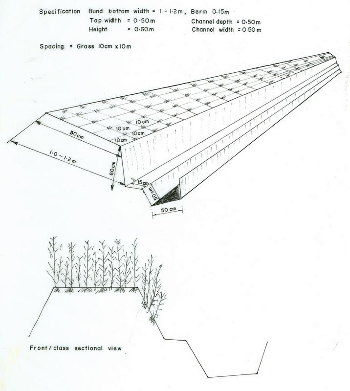
Technical specifications (related to technical drawing):
SNNPR
Technical knowledge required for field staff / advisors: moderate
Technical knowledge required for land users: high
Main technical functions: control of dispersed runoff: retain / trap, control of dispersed runoff: impede / retard
Secondary technical functions: control of concentrated runoff: retain / trap, control of concentrated runoff: impede / retard, control of concentrated runoff: drain / divert, reduction of slope length, increase of infiltration, sediment retention / trapping, sediment harvesting
Contour planting / strip cropping
Material/ species: Desho grass
Quantity/ density: 15m3/km
Remarks: 10m X 10m
Contour tillage
Remarks: farm implements
Contour ridging
Remarks: shovel, hoe, pick axe
Aligned: -contour
Vegetative material: T : trees / shrubs, F : fruit trees / shrubs, G : grass
Number of plants per (ha): 750
Vertical interval between rows / strips / blocks (m): 1
Vertical interval within rows / strips / blocks (m): 0.1
Width within rows / strips / blocks (m): 1
Trees/ shrubs species: Cajans cajan, Sesbania sesban
Fruit trees / shrubs species: Avocado, casmir
Grass species: Desho grass
Slope (which determines the spacing indicated above): 30.00%
If the original slope has changed as a result of the Technology, the slope today is (see figure below): 15.00%
Gradient along the rows / strips: 0.00%
Bund/ bank: level
Vertical interval between structures (m): 1
Spacing between structures (m): 20-30
Depth of ditches/pits/dams (m): 0.3
Width of ditches/pits/dams (m): 0.5
Length of ditches/pits/dams (m): 100
Height of bunds/banks/others (m): 0.6
Width of bunds/banks/others (m): 0.8-1.2
Length of bunds/banks/others (m): 100
Structural measure: diversion ditch / cut-off drain
Depth of ditches/pits/dams (m): 0.4
Width of ditches/pits/dams (m): 0.5
Length of ditches/pits/dams (m): 100
Height of bunds/banks/others (m): 0.3
Width of bunds/banks/others (m): 0.5
Length of bunds/banks/others (m): 100
Construction material (earth): Soil bund
Slope (which determines the spacing indicated above): 30%
If the original slope has changed as a result of the Technology, the slope today is: 15%
Lateral gradient along the structure: 0%
Vegetation is used for stabilisation of structures.
Change of land use type: open grazing to cut and carry
Major change in timing of activities: harvesting Desho grass every two month
Other type of management: change of management / intensity level - from mono-crop to rotational cropping
4.2 General information regarding the calculation of inputs and costs
other/ national currency (specify):
Birr
If relevant, indicate exchange rate from USD to local currency (e.g. 1 USD = 79.9 Brazilian Real): 1 USD =:
8.6
Indicate average wage cost of hired labour per day:
0.75
4.3 Establishment activities
| Activity | Timing (season) | |
|---|---|---|
| 1. | Collecting grass | beginning of rain season |
| 2. | Transporting planting materials | beginning of rain season |
| 3. | Planting grass on the bund | beginning of rain season |
| 4. | Catchment survey | dry season |
| 5. | Cutoff drain construction | dry season |
| 6. | Soil bund construction | dry season |
| 7. | Grass transplanting | onset of rains |
| 8. | Grass planting | onset of rains |
4.4 Costs and inputs needed for establishment
| Specify input | Unit | Quantity | Costs per Unit | Total costs per input | % of costs borne by land users | |
|---|---|---|---|---|---|---|
| Labour | Labour | ha | 1.0 | 8.0 | 8.0 | 100.0 |
| Equipment | Machine use | ha | 1.0 | 1.21 | 1.21 | |
| Equipment | Tools | ha | 1.0 | 1.7 | 1.7 | |
| Plant material | Seedlings | ha | 1.0 | 3.2 | 3.2 | |
| Total costs for establishment of the Technology | 14.11 | |||||
| Total costs for establishment of the Technology in USD | 1.64 | |||||
Comments:
Duration of establishment phase: 12 month(s)
4.5 Maintenance/ recurrent activities
| Activity | Timing/ frequency | |
|---|---|---|
| 1. | Land preparation | onset of rains / 1-3 |
| 2. | Sowing | during rains / each cropping season |
| 3. | Weeding | |
| 4. | Collecting grass | |
| 5. | Transporting planting materials | |
| 6. | Planting grass on the bund | |
| 7. | Cutoff drain desilted | before rains/annual |
| 8. | Soil bund maintenance | before rains/annual |
| 9. | Grass replanting | during rains/annual |
4.6 Costs and inputs needed for maintenance/ recurrent activities (per year)
Comments:
Machinery/ tools: shovel, hoe
Length of structure and grass strip
4.7 Most important factors affecting the costs
Describe the most determinate factors affecting the costs:
Cost/labour and requirment increased as slope increased.
5. Natural and human environment
5.1 Climate
Annual rainfall
- < 250 mm
- 251-500 mm
- 501-750 mm
- 751-1,000 mm
- 1,001-1,500 mm
- 1,501-2,000 mm
- 2,001-3,000 mm
- 3,001-4,000 mm
- > 4,000 mm
Specifications/ comments on rainfall:
1001-1500 (1200 mm, ranked 1)
751-1000 (900 mm, ranked 2)
Agro-climatic zone
- sub-humid
5.2 Topography
Slopes on average:
- flat (0-2%)
- gentle (3-5%)
- moderate (6-10%)
- rolling (11-15%)
- hilly (16-30%)
- steep (31-60%)
- very steep (>60%)
Landforms:
- plateau/plains
- ridges
- mountain slopes
- hill slopes
- footslopes
- valley floors
Altitudinal zone:
- 0-100 m a.s.l.
- 101-500 m a.s.l.
- 501-1,000 m a.s.l.
- 1,001-1,500 m a.s.l.
- 1,501-2,000 m a.s.l.
- 2,001-2,500 m a.s.l.
- 2,501-3,000 m a.s.l.
- 3,001-4,000 m a.s.l.
- > 4,000 m a.s.l.
Comments and further specifications on topography:
Altitudinal zone: <2400m a.s.l.
Landforms: Hill slopes (most of the catchment area up to 50% slope, ranked 1) and plateau/plains (around 10% slope, ranked 2)
Slopes on average: Also hilly (ranked 2) and rolling (ranked 3)
5.3 Soils
Soil depth on average:
- very shallow (0-20 cm)
- shallow (21-50 cm)
- moderately deep (51-80 cm)
- deep (81-120 cm)
- very deep (> 120 cm)
Soil texture (topsoil):
- fine/ heavy (clay)
Topsoil organic matter:
- low (<1%)
If available, attach full soil description or specify the available information, e.g. soil type, soil PH/ acidity, Cation Exchange Capacity, nitrogen, salinity etc.
Soil texture: Fine/heavy (clay loam)
Soil fertility: Very low (production is very low with out organic/chemical fertilizer, ranked 1) and low (production is low with out organic/chemical fertilizer, ranked 2)
Topsoil organic matter: Low (top fertile soil is eroded away)
Soil drainage/infiltration: Good (well drained nitosols)
Soil water storage capacity: Medium (lack of organic matter)
5.6 Characteristics of land users applying the Technology
Market orientation of production system:
- subsistence (self-supply)
Off-farm income:
- less than 10% of all income
Relative level of wealth:
- average
- rich
Level of mechanization:
- manual work
- animal traction
Indicate other relevant characteristics of the land users:
Population density: 200-500 persons/km2
Annual population growth: 3% - 4%
28% of the land users are rich and own 40% of the land.
58% of the land users are average wealthy and own 50% of the land.
14% of the land users are poor and own 10% of the land.
Off-farm income specification: There is little difference between them.
Level of mechanization: Animal traction (ranked 1, on gentle to hilly slope oxen is used for ploughing) and manual work (ranked 2, manual labour is used on steep slopes)
Market orientation of cropland production system: subsistence (self-supply) land users produce crop for household consumption
Market orientation of grazing land production system: subsistence (self-supply) cattle rearing is for own use, traction and saving.
Market orientation of forest production system: subsistence (self-supply) and agroforestry
Market orientation of production system: agroforestry
5.7 Average area of land used by land users applying the Technology
- < 0.5 ha
- 0.5-1 ha
- 1-2 ha
- 2-5 ha
- 5-15 ha
- 15-50 ha
- 50-100 ha
- 100-500 ha
- 500-1,000 ha
- 1,000-10,000 ha
- > 10,000 ha
Comments:
Cropland: Land holding is less than 0.5 ha
Grazing and forest land is 1ha
6. Impacts and concluding statements
6.1 On-site impacts the Technology has shown
Socio-economic impacts
Production
crop production
Comments/ specify:
land productivity is improved
fodder production
Comments/ specify:
desho grass became ample forage resources
fodder quality
Comments/ specify:
desho grass became ample forage resources
wood production
Income and costs
farm income
Comments/ specify:
from sells of Desho grass and animal product
Socio-cultural impacts
community institutions
Comments/ specify:
strengthen group working, e.g. community development committee (CDC)
national institutions
Comments/ specify:
Introduce strong approach, Integrated Watershed Management
SLM/ land degradation knowledge
Comments/ specify:
use of Desho grass for bund stablization
Ecological impacts
Soil
soil moisture
Comments/ specify:
excess water is retained behind the bund and infiltrate
soil cover
Comments/ specify:
Desho grass cover the bund
soil loss
Quantity before SLM:
70
Quantity after SLM:
4
Comments/ specify:
bund stablized with Desho grass is effctive in conserving the soil
6.2 Off-site impacts the Technology has shown
downstream flooding
Comments/ specify:
reduce flooding
downstream siltation
groundwater/ river pollution
6.4 Cost-benefit analysis
How do the benefits compare with the establishment costs (from land users’ perspective)?
Short-term returns:
very positive
Long-term returns:
very positive
How do the benefits compare with the maintenance/ recurrent costs (from land users' perspective)?
Short-term returns:
very positive
Long-term returns:
very positive
6.5 Adoption of the Technology
Comments:
66% of land user families have adopted the Technology with external material support
4145 land user families have adopted the Technology with external material support
Comments on acceptance with external material support: survey results
There is a strong trend towards spontaneous adoption of the Technology
Comments on adoption trend: The grass is very fast growing, easly to established and naturally palatable, good for stablizing bund, harvest once a month during rainy season and grows at right position and therefore it does not hinder other farm activities.
6.7 Strengths/ advantages/ opportunities of the Technology
| Strengths/ advantages/ opportunities in the land user’s view |
|---|
|
Palatable grass How can they be sustained / enhanced? encourage cut and carry system. |
| fast growing grass |
| Substitute enset as a source of forage |
| Generate income |
| Strengths/ advantages/ opportunities in the compiler’s or other key resource person’s view |
|---|
|
Good and fast growing grass that can cover the bund with in short time. How can they be sustained / enhanced? avoid free grazing and encourage cut and carry system. |
|
Little investment for establishment How can they be sustained / enhanced? Provision of planting materials for resource poor land users. |
|
Good palatable nature How can they be sustained / enhanced? encourage cut and carry system. |
|
Land productivity improved How can they be sustained / enhanced? access to market and introduce improved varities. |
7. References and links
7.1 Methods/ sources of information
7.2 References to available publications
Title, author, year, ISBN:
SOS Sahel IFSSP Terminal evaluation Report. 2003.
Title, author, year, ISBN:
Case study assessing the signifcance of Desho grass intervention on SWC structures, Food security Strategy, by Daniel Dantamo.
Links and modules
Expand all Collapse allLinks
No links
Modules
No modules