Afforestation and Hillside Terracing [Eritrea]
- Creation:
- Update:
- Compiler: Eyob Zeremariam
- Editor: –
- Reviewers: Fabian Ottiger, Alexandra Gavilano
technologies_1330 - Eritrea
View sections
Expand all Collapse all1. General information
1.2 Contact details of resource persons and institutions involved in the assessment and documentation of the Technology
SLM specialist:
Bereket Tsehaye
Toker Integrated Community Development
Eritrea
Name of project which facilitated the documentation/ evaluation of the Technology (if relevant)
Book project: SLM in Practice - Guidelines and Best Practices for Sub-Saharan Africa (SLM in Practice)Name of the institution(s) which facilitated the documentation/ evaluation of the Technology (if relevant)
Toker Integrated Community Development - EritreaName of the institution(s) which facilitated the documentation/ evaluation of the Technology (if relevant)
Ministry of Agriculture of Eritrea (Ministry of Agriculture of Eritrea) - Eritrea1.3 Conditions regarding the use of data documented through WOCAT
The compiler and key resource person(s) accept the conditions regarding the use of data documented through WOCAT:
Yes
2. Description of the SLM Technology
2.1 Short description of the Technology
Definition of the Technology:
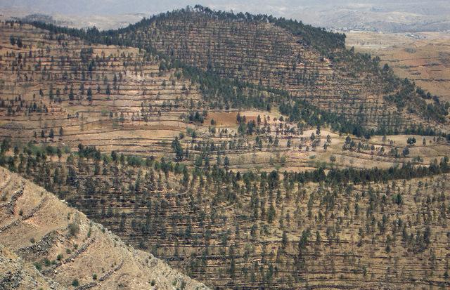
Tree plantations in combination with hillside terracing to protect upper catchment areas are a widespread technology in the Central and Northern Highland Zone of Eritrea.
2.2 Detailed description of the Technology
Description:
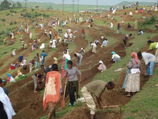
In the early 1990s a large area was treated in the Toker catchment, northwest of Asmara. The first step was to establish hillside terraces on the steeper slopes where it is essential to conserve soil and water for improved growth of trees and other vegetation. The terraces comprise earthen embankments laid out along the along the contour, reinforced with stone risers, combined with a trench on the upper side to harvest runoff water. The trenches are subdivided into basins (by ties) to avoid lateral flow of runoff water. In a second step, trees were planted at a spacing of 2 m (in the trenches). Mostly fast growing eucalyptus was used, with a very small percentage of the indigenous African olive (Olea africana) - which has good survival rates but grows very slowly. Afforested areas are closed for any use until the trees reach maturity: they are protected by guards. In 1995 the Ministry of Agriculture handed over user rights to communities allowing cut-and-carry of grass and cutting of trees (with permission of the government). The technology requires appreciable expense, labor and expertise, but if maintained well, it results in multiple ecological and economic benefits: Soil cover has improved, water is conserved, the severe problems of soil erosion have been reduced, and dams further downstream are protected from siltation. Trees have become an important source of income for the rural communities, wood is a valuable resource mainly needed for construction, and also as fuel. Since the 1960s, several afforestation campaigns have been initiated by the government, mainly using food-for-work or cash-for-work approaches as incentives. Nowadays, local tree planting initiatives (on community or individual level) without external support are dominant.
2.3 Photos of the Technology
Media Gallery
2.5 Country/ region/ locations where the Technology has been applied and which are covered by this assessment
Country:
Eritrea
Region/ State/ Province:
Central Highlands
Further specification of location:
Serejeka
Specify the spread of the Technology:
- evenly spread over an area
If the Technology is evenly spread over an area, specify area covered (in km2):
30.0
Comments:
Total area covered by the SLM Technology is 30 km2.
2.6 Date of implementation
If precise year is not known, indicate approximate date:
- 10-50 years ago
2.7 Introduction of the Technology
Specify how the Technology was introduced:
- through projects/ external interventions
3. Classification of the SLM Technology
3.1 Main purpose(s) of the Technology
- reduce, prevent, restore land degradation
3.2 Current land use type(s) where the Technology is applied

Cropland
- Tree and shrub cropping
Tree and shrub cropping - Specify crops:
- olive

Forest/ woodlands
- Tree plantation, afforestation
Type of tree:
- Eucalyptus species
Products and services:
- Timber
- Fuelwood
- Grazing/ browsing
Comments:
Major land use problems (land users’ perception): Surface and gully erosion; Decline of vegetation cover, diversity and biomass; Loss of surface water; Lowering of ground water level
Plantation forestry: Yes
Trees/ shrubs species: Eucalyptus, few Olea africana
3.4 Water supply
Water supply for the land on which the Technology is applied:
- rainfed
3.5 SLM group to which the Technology belongs
- natural and semi-natural forest management
- cross-slope measure
3.6 SLM measures comprising the Technology

vegetative measures
- V1: Tree and shrub cover

structural measures
- S1: Terraces
Comments:
Main measures: vegetative measures, structural measures
Type of vegetative measures: aligned: -contour
3.7 Main types of land degradation addressed by the Technology

soil erosion by water
- Wt: loss of topsoil/ surface erosion
- Wg: gully erosion/ gullying

biological degradation
- Bc: reduction of vegetation cover
- Bq: quantity/ biomass decline
- Bs: quality and species composition/ diversity decline

water degradation
- Hg: change in groundwater/aquifer level
Comments:
Main type of degradation addressed: Wt: loss of topsoil / surface erosion, Wg: gully erosion / gullying, Bc: reduction of vegetation cover, Bq: quantity / biomass decline, Bs: quality and species composition /diversity decline, Hg: change in groundwater / aquifer level
3.8 Prevention, reduction, or restoration of land degradation
Specify the goal of the Technology with regard to land degradation:
- restore/ rehabilitate severely degraded land
4. Technical specifications, implementation activities, inputs, and costs
4.1 Technical drawing of the Technology
Technical specifications (related to technical drawing):
Technical knowledge required for field staff / advisors: moderate
Technical knowledge required for land users: high
Main technical functions: control of raindrop splash, control of dispersed runoff: retain / trap, reduction of slope angle, improvement of ground cover, stabilisation of soil (eg by tree roots against land slides), increase of infiltration, increase of groundwater level / recharge of groundwater, increase of biomass (quantity), promotion of vegetation species and varieties (quality, eg palatable fodder)
Aligned: -contour
Vegetative material: T : trees / shrubs
Vertical interval within rows / strips / blocks (m): 2.00
Trees/ shrubs species: Eucalyptus, few Olea africana
Terrace: bench level
Spacing between structures (m): 2.50
Depth of ditches/pits/dams (m): 0.50
Construction material (earth): digging out trenches and piling up risers
Construction material (stone): risers should be reinforced with stones
Vegetation is used for stabilisation of structures.
4.3 Establishment activities
| Activity | Timing (season) | |
|---|---|---|
| 1. | Dig planting pits (0.5 x 0.5x 0.5 m), at 2 m intervals, in the trenches | |
| 2. | Plant tree seedlings (mainly eucalypts, some African olives); fill pit with top soil (optional: mix with 1 spade of manure) | |
| 3. | Spot weeding and softening soil around the pits to improve percolation of water and soil aeration (during rainy season) | |
| 4. | Supplementary irrigation during dry spells (using jerry / watering cans) | |
| 5. | Prohibit open grazing: Area closure is done collectively | |
| 6. | Mark contour lines using a line level. Spacing between terraces depends on slope, vegetation status, soil depth. In the case study area horizontal spacing between terraces is 2.5 m | |
| 7. | Terraces are built (inward-sloping) by digging out trenches (0.5 m deep) and piling up risers (minimum 0.75 m high). Risers should be reinforced with stones (where available) | |
| 8. | The trenches are separated into basins by ties at an interval of 2-5 m to avoid eventual lateral movement of water |
4.4 Costs and inputs needed for establishment
| Specify input | Unit | Quantity | Costs per Unit | Total costs per input | % of costs borne by land users | |
|---|---|---|---|---|---|---|
| Labour | Labour | ha | 1.0 | 1760.0 | 1760.0 | 73.0 |
| Equipment | Tools | ha | 1.0 | 50.0 | 50.0 | 73.0 |
| Plant material | Seedlings | ha | 1.0 | 600.0 | 600.0 | 73.0 |
| Total costs for establishment of the Technology | 2410.0 | |||||
| Total costs for establishment of the Technology in USD | 2410.0 | |||||
4.5 Maintenance/ recurrent activities
| Activity | Timing/ frequency | |
|---|---|---|
| 1. | Replacement of missing plants at onset of rains (10% replacement of seedlings is expected in the 1st year) | onset of rains |
| 2. | Spot weeding and softening soil | |
| 3. | Supplementary irrigation | |
| 4. | Maintenance of structures | before onset of rainy season |
4.6 Costs and inputs needed for maintenance/ recurrent activities (per year)
| Specify input | Unit | Quantity | Costs per Unit | Total costs per input | % of costs borne by land users | |
|---|---|---|---|---|---|---|
| Labour | Labour | ha | 1.0 | 480.0 | 480.0 | 83.0 |
| Plant material | Seedlings | ha | 1.0 | 100.0 | 100.0 | 83.0 |
| Total costs for maintenance of the Technology | 580.0 | |||||
| Total costs for maintenance of the Technology in USD | 580.0 | |||||
Comments:
Costs are calculated for gentle slopes with a terraces spaced at 2.5 m.
4.7 Most important factors affecting the costs
Describe the most determinate factors affecting the costs:
Labour cost includes construction of hillside terrace, pitting, planting and spot weeding and cultivation. According to the work and payment norms of the Ministry of Agriculture the cost of 1 person-day is 2.66 US$. Production cost of one seedling is 0.2 US$. Maintenance costs include terrace maintenance, re-pitting and replanting of seedlings.
5. Natural and human environment
5.1 Climate
Annual rainfall
- < 250 mm
- 251-500 mm
- 501-750 mm
- 751-1,000 mm
- 1,001-1,500 mm
- 1,501-2,000 mm
- 2,001-3,000 mm
- 3,001-4,000 mm
- > 4,000 mm
Agro-climatic zone
- semi-arid
Thermal climate class: tropics
5.2 Topography
Slopes on average:
- flat (0-2%)
- gentle (3-5%)
- moderate (6-10%)
- rolling (11-15%)
- hilly (16-30%)
- steep (31-60%)
- very steep (>60%)
Landforms:
- plateau/plains
- ridges
- mountain slopes
- hill slopes
- footslopes
- valley floors
Altitudinal zone:
- 0-100 m a.s.l.
- 101-500 m a.s.l.
- 501-1,000 m a.s.l.
- 1,001-1,500 m a.s.l.
- 1,501-2,000 m a.s.l.
- 2,001-2,500 m a.s.l.
- 2,501-3,000 m a.s.l.
- 3,001-4,000 m a.s.l.
- > 4,000 m a.s.l.
Comments and further specifications on topography:
Landforms: Also hill slopes
Slopes on average are steep ( > 50%)
Soil fertility is low
5.3 Soils
Soil depth on average:
- very shallow (0-20 cm)
- shallow (21-50 cm)
- moderately deep (51-80 cm)
- deep (81-120 cm)
- very deep (> 120 cm)
Soil texture (topsoil):
- coarse/ light (sandy)
- medium (loamy, silty)
Topsoil organic matter:
- low (<1%)
5.6 Characteristics of land users applying the Technology
Market orientation of production system:
- subsistence (self-supply)
- mixed (subsistence/ commercial)
Individuals or groups:
- groups/ community
Level of mechanization:
- manual work
- animal traction
Indicate other relevant characteristics of the land users:
Land users applying the Technology are mainly disadvantaged land users
Market orientation of production system: subsistence (self-supply), subsistence (self-supply), mixed (subsistence/ commercial, mixed (subsistence/ commercial
5.7 Average area of land used by land users applying the Technology
- < 0.5 ha
- 0.5-1 ha
- 1-2 ha
- 2-5 ha
- 5-15 ha
- 15-50 ha
- 50-100 ha
- 100-500 ha
- 500-1,000 ha
- 1,000-10,000 ha
- > 10,000 ha
Is this considered small-, medium- or large-scale (referring to local context)?
- small-scale
5.8 Land ownership, land use rights, and water use rights
Land ownership:
- state
Land use rights:
- communal (organized)
6. Impacts and concluding statements
6.1 On-site impacts the Technology has shown
Socio-economic impacts
Production
fodder production
Comments/ specify:
cut-and-carry of grass
wood production
Income and costs
diversity of income sources
Comments/ specify:
selling timber and grass
Socio-cultural impacts
food security/ self-sufficiency
recreational opportunities
community institutions
SLM/ land degradation knowledge
conflict mitigation
Ecological impacts
Water cycle/ runoff
surface runoff
groundwater table/ aquifer
Soil
soil moisture
soil cover
soil loss
soil organic matter/ below ground C
Biodiversity: vegetation, animals
biomass/ above ground C
6.2 Off-site impacts the Technology has shown
reliable and stable stream flows in dry season
downstream flooding
6.3 Exposure and sensitivity of the Technology to gradual climate change and climate-related extremes/ disasters (as perceived by land users)
Climate-related extremes (disasters)
Climatological disasters
| How does the Technology cope with it? | |
|---|---|
| drought | not well |
Comments:
Sensitive to climatic extremes (e.g. rainfall decrease, especially in case of monocultures)
6.4 Cost-benefit analysis
How do the benefits compare with the establishment costs (from land users’ perspective)?
Short-term returns:
slightly negative
Long-term returns:
very positive
How do the benefits compare with the maintenance/ recurrent costs (from land users' perspective)?
Short-term returns:
neutral/ balanced
Long-term returns:
positive
Comments:
Initial labour inputs payout on long term
6.5 Adoption of the Technology
Of all those who have adopted the Technology, how many did so spontaneously, i.e. without receiving any material incentives/ payments?
- 0-10%
Comments:
100% of land user families have adopted the Technology with external material support
There is a moderate trend towards spontaneous adoption of the Technology
Comments on adoption: Acceptance of afforestation areas has increased, since user rights have been given to land users: Communities located in Toker upper catchment areas have taken the initiative to maintain and protect their woodlots. Moreover, there is a trend toward locally initiated hillside terracing and tree planting without external initiative/incentives, apart from the provision of seedlings (through Ministry of Agriculture). The afforestation area covers approx. 30 km2 with high potential to enlarge.
6.7 Strengths/ advantages/ opportunities of the Technology
| Strengths/ advantages/ opportunities in the compiler’s or other key resource person’s view |
|---|
| Protection of slopes from erosion while at the same time providing an income source for the poor |
6.8 Weaknesses/ disadvantages/ risks of the Technology and ways of overcoming them
| Weaknesses/ disadvantages/ risks in the land user’s view | How can they be overcome? |
|---|---|
| Establishment cost is high and labour intensiv | provision of hand tools and demanded seedlings |
| Fast growing eucalyptus trees have a high rate of water consumption; Indigenous trees are not favoured | encourage people to protect naturally regenerated indigenous trees, assist villagers to get market channels for products of indigenous trees |
| Community mobilization and high knowledge of land users is required | awareness raising campaigns, strengthen village institutional arrangements, assist villages bylaws |
| Land use rights: because the afforestation area is communal, nobody feels responsible for maintenance | promote plantations by individual households |
7. References and links
7.2 References to available publications
Title, author, year, ISBN:
Zeremariam I. 2001. Assessment of upper catchment development technologies in the Central High Land zone of Eritrea. MSc Thesis; The Royal Veterinary and Agricultural University, Denmark.
Title, author, year, ISBN:
Amanuel Negasi et al. 2002. Soil and water conservation Manual for Eritrea. RELMA.
Title, author, year, ISBN:
Zeremariam I.2001. Assessment of upper catchment Development Technologies and Approaches in the Central High Land zone of Eritrea. MSc Thesis; The Royal Veterinary and Agricultural University, Denmark
Links and modules
Expand all Collapse allLinks
No links
Modules
No modules