Forest catchment treatment [India]
- Creation:
- Update:
- Compiler: Chetan Kumar
- Editor: –
- Reviewers: Fabian Ottiger, Alexandra Gavilano
technologies_1476 - India
View sections
Expand all Collapse all1. General information
1.2 Contact details of resource persons and institutions involved in the assessment and documentation of the Technology
SLM specialist:
Vashisth US
India
Name of project which facilitated the documentation/ evaluation of the Technology (if relevant)
Book project: where the land is greener - Case Studies and Analysis of Soil and Water Conservation Initiatives Worldwide (where the land is greener)Name of the institution(s) which facilitated the documentation/ evaluation of the Technology (if relevant)
Center for International Forestry Research (CIFOR) (Center for International Forestry Research (CIFOR)) - India1.3 Conditions regarding the use of data documented through WOCAT
The compiler and key resource person(s) accept the conditions regarding the use of data documented through WOCAT:
Yes
1.5 Reference to Questionnaire(s) on SLM Approaches (documented using WOCAT)

Joint forest management [India]
Government and NGO supported community protection of forested catchments, through village-based Hill Resource Management Societies.
- Compiler: Sumana Datta
Joint forest management [India]
Joint forest management is a community based program developed in collaboration with the forest department for the protection and management of local forests while providing incentives to the local communities with political and institutional support from the state.
- Compiler: Sumana Datta
2. Description of the SLM Technology
2.1 Short description of the Technology
Definition of the Technology:
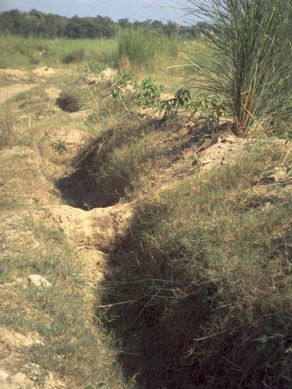
Catchment treatment of degraded forest land including social fencing, infiltration trenches and enrichment planting with trees and grasses for production and dam protection.
2.2 Detailed description of the Technology
Description:
Forest catchment treatment aims to achieve production and environmental benefits through a combination of structural, vegetative and management measures in badly degraded catchments above villages. These efforts are concentrated in the highly erodible Shiwalik Hills at the foot of the Himalayan range where soil erosion has ravaged the landscape, and the original forest has almost disappeared.
The purpose of forest catchment treatment is first to rehabilitate the forest through protection of the area by ‘social fencing’ (villagers agreeing amongst themselves to exclude livestock without using physical barriers), then construction of soil conservation measures (staggered contour trenches, check dams, graded stabilisation channels etc; see establishment activities), and ‘enrichment planting’ of trees and grasses within the existing forest stand to improve composition and cover. These species usually include trees such as Acacia catechu and Dalbergia sissoo, and fodder grasses - as well as bhabbar grass (Eulaliopsis binata), which is used for rope making. The combined measures are aimed at reestablishing the forest canopy, understorey and floor, thereby restoring the forest ecosystem together with its functions and services. Biodiversity is simultaneously enhanced.
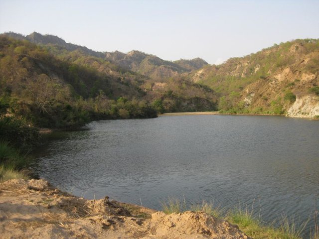
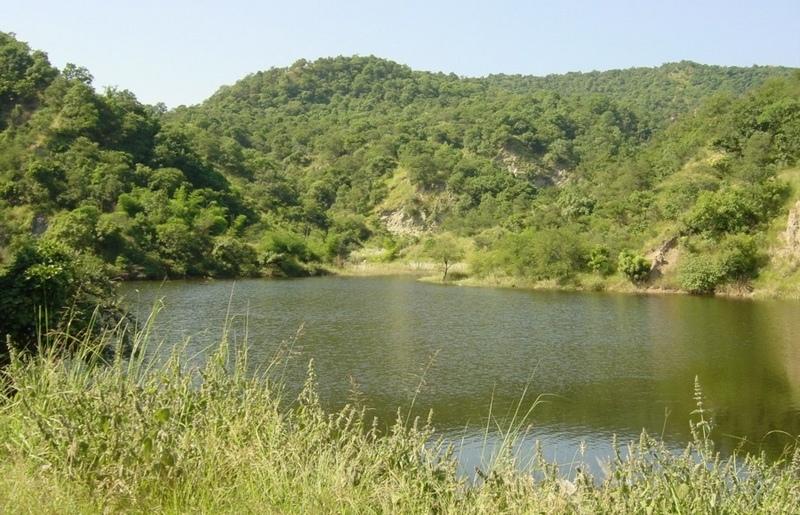
The second main objective is to provide supplementary irrigation water to the village below through construction of one, or more, earth dams. The village community - organised into a Hill Resource Management Society - is the source of highly subsidised labour for forest catchment treatment. After catchment protection around the proposed dam site(s), the dam(s) and pipeline(s) are constructed. The dams are generally between 20,000 and 200,000 m3 in capacity, and the pipelines usually one kilometre or less in length.
Apart from irrigation, the villagers benefit from communal use of non-timber forest resources. Forest catchment treatment (associated with the approach termed ‘joint forest management’ - JFM) has been developed from a pilot initiative in Sukhomajri village in 1976, and has spread very widely throughout India. This description focuses on Ambala and Yamunanagar Districts in Haryana State.
The Shiwalik hills where the SWC technology was applied is one of the eight most degraded, rainfed agro-ecosystems of India. It is highly erodible, with presence of low water retentive soils and severe soil erosion, haing water scarcity despite average 1000 mm annual rainfall.
2.3 Photos of the Technology
Media Gallery
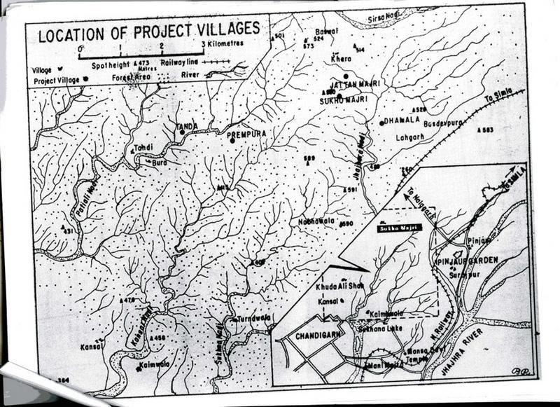
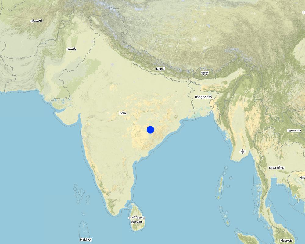
2.5 Country/ region/ locations where the Technology has been applied and which are covered by this assessment
Country:
India
Region/ State/ Province:
Haryana
Further specification of location:
Ambala and Yamunanagar
Comments:
Total area covered by the SLM Technology is 198 km2.
Map
×3. Classification of the SLM Technology
3.1 Main purpose(s) of the Technology
- improve production
- reduce, prevent, restore land degradation
3.2 Current land use type(s) where the Technology is applied
Land use mixed within the same land unit:
Yes
Specify mixed land use (crops/ grazing/ trees):
- Silvo-pastoralism

Grazing land

Forest/ woodlands
- Rehabilitated natural forest
Type of tree:
- Acacia species
- Dalbergia sissoo
Comments:
Major land use problems (compiler’s opinion): The Shiwalik Hills are extremely prone to both surface erosion and landslides, and general degradation of vegetation due to over-exploitation. Some areas have become completely denuded because of overgrazing and woodcutting. Furthermore there is no, or inadequate, water for irrigation of crops.
Grazingland comments: Due to free grazing, much of the forest land was becoming barren and fodder yield declined over a period of time. The average fodder yield was about two quintals/ha of forest land and fodder consumption was 26.69kg/animal/day.
Problems / comments regarding forest use: Tree species like Khaci (Acacia catechu), Dalbergio sissoo in pits and slips of bhabbar grass (Eulaliopsis binata) on mounds of trenches and hill slopes were planted. Bhabbar grass was sold out by forest department to contractors.
Type of grazing system comments: Due to free grazing, much of the forest land was becoming barren and fodder yield declined over a period of time. The average fodder yield was about two quintals/ha of forest land and fodder consumption was 26.69kg/animal/day.
Longest growing period in days: 120 Longest growing period from month to month: Jul - Oct
3.5 SLM group to which the Technology belongs
- area closure (stop use, support restoration)
- improved ground/ vegetation cover
- cross-slope measure
3.6 SLM measures comprising the Technology

structural measures
Comments:
Main measures: structural measures
Secondary measures: vegetative measures, management measures
3.7 Main types of land degradation addressed by the Technology

soil erosion by water
- Wt: loss of topsoil/ surface erosion
- Wg: gully erosion/ gullying
- Wm: mass movements/ landslides

water degradation
- Ha: aridification
Comments:
Main type of degradation addressed: Wt: loss of topsoil / surface erosion
Secondary types of degradation addressed: Wg: gully erosion / gullying, Wm: mass movements / landslides, Ha: aridification
Main causes of degradation: deforestation / removal of natural vegetation (incl. forest fires), education, access to knowledge and support services (Absence of institutional arrangements to disseminate the knowledge from lab to land and involve the users in implementation)
Secondary causes of degradation: overgrazing (Subsistence economy, dependance on forests for fuelwood and fodder, livestock were low quality, free grazing type. And these were no regulatory mechanisms to share usufruct from forests with people.), poverty / wealth (Lack of capital at the grassroot to take the initiative by the farmers themselves)
3.8 Prevention, reduction, or restoration of land degradation
Specify the goal of the Technology with regard to land degradation:
- reduce land degradation
4. Technical specifications, implementation activities, inputs, and costs
4.1 Technical drawing of the Technology
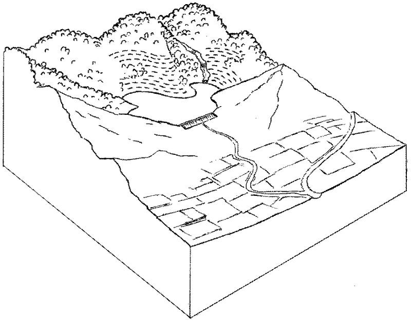
Technical specifications (related to technical drawing):
Forest catchment treatment: an overview showing protected forest, dam and irrigated cropland below.
Technical knowledge required for field staff / advisors: moderate
Technical knowledge required for land users: moderate
Main technical functions: increase of infiltration, water harvesting / increase water supply
Secondary technical functions: control of dispersed runoff: retain / trap, improvement of ground cover, control of concentrated runoff
Vegetative measure: enrichment planting with
Vegetative material: T : trees / shrubs, G : grass
Vegetative measure: Vegetative material: T : trees / shrubs, G : grass
Vegetative measure: Vegetative material: T : trees / shrubs, G : grass
Vegetative measure: Vegetative material: T : trees / shrubs, G : grass
Trees/ shrubs species: Acacia catechu, Dalbergia sissoo etc
Grass species: bhabbar grass: Eulaliopsis binata
Structural measure: dam
Structural measure: trenches
Structural measure: ditches
Structural measure: check dams
Other type of management: social fencing
Author:
Mats Gurtner
4.3 Establishment activities
| Activity | Timing (season) | |
|---|---|---|
| 1. | Enrichment planting of tree seedlings (Acacia catechu, Dalbergiasissoo etc), grasses (bhabbar grass: Eulaliopsis binata) on bundsof earth and hill slopes, and Ipomea cornea in channels. | beginning of the monsoon rains. |
| 2. | Construction of a series of staggered contour trenches on slopes. | pre-monsoon |
| 3. | Construction of stone/earth/wood check dams in gullies. | pre-monsoon |
| 4. | Construction of graded stabilisation channels which capture runoffand discharge it safely. | pre-monsoon |
| 5. | Construction of earth dam wall for water harvesting and concretepipelines for irrigation. | pre-monsoon |
| 6. | Introduction of social fencing system through Hill ResourceManagement Societies. | pre-monsoon |
4.4 Costs and inputs needed for establishment
| Specify input | Unit | Quantity | Costs per Unit | Total costs per input | % of costs borne by land users | |
|---|---|---|---|---|---|---|
| Labour | Labour | ha | 1.0 | 250.0 | 250.0 | 5.0 |
| Equipment | Machine use | ha | 1.0 | 75.0 | 75.0 | |
| Plant material | Seedlings | ha | 1.0 | 50.0 | 50.0 | |
| Construction material | Construction material for dam wall | ha | 1.0 | 25.0 | 25.0 | |
| Total costs for establishment of the Technology | 400.0 | |||||
| Total costs for establishment of the Technology in USD | 400.0 | |||||
Comments:
Duration of establishment phase: 36 month(s)
4.5 Maintenance/ recurrent activities
| Activity | Timing/ frequency | |
|---|---|---|
| 1. | watch and ward | /on-going |
| 2. | Desilting of water harvesting structures. | pre-monsoon,/once every year |
| 3. | Repair of channels. | pre-monsoon,/once every year |
| 4. | Maintenance of structures. | pre-monsoon,/ |
| 5. | regular meetings/facilitations | |
| 6. | control grazing fines, peer-group pressure |
4.6 Costs and inputs needed for maintenance/ recurrent activities (per year)
| Specify input | Unit | Quantity | Costs per Unit | Total costs per input | % of costs borne by land users | |
|---|---|---|---|---|---|---|
| Labour | Labour | ha | 1.0 | 50.0 | 50.0 | 95.0 |
| Total costs for maintenance of the Technology | 50.0 | |||||
| Total costs for maintenance of the Technology in USD | 50.0 | |||||
Comments:
This information is indicative and is based on calculations derived from Thaska village (Yamunanagar District)
where there are 3 dams - collecting the runoff from the total forest catchment of 75 ha. The cost range of treatments per
hectare of rehabilitated forest is generally US$ 200–700 (where the main cost is that of the dam construction) and typically the area of supplementary irrigation (command area) is twice as large as the forest catchment treated (in this case the irrigated area is 150 ha).
Cost per unit: the treatment of a 25 ha unit of catchment including construction of a dam costs around US$ 10,000.
5. Natural and human environment
5.1 Climate
Annual rainfall
- < 250 mm
- 251-500 mm
- 501-750 mm
- 751-1,000 mm
- 1,001-1,500 mm
- 1,501-2,000 mm
- 2,001-3,000 mm
- 3,001-4,000 mm
- > 4,000 mm
Agro-climatic zone
- sub-humid
- semi-arid
Semi arid: Shiwalik region falls under semi-arid agro-climatic zone.
5.2 Topography
Slopes on average:
- flat (0-2%)
- gentle (3-5%)
- moderate (6-10%)
- rolling (11-15%)
- hilly (16-30%)
- steep (31-60%)
- very steep (>60%)
Landforms:
- plateau/plains
- ridges
- mountain slopes
- hill slopes
- footslopes
- valley floors
Altitudinal zone:
- 0-100 m a.s.l.
- 101-500 m a.s.l.
- 501-1,000 m a.s.l.
- 1,001-1,500 m a.s.l.
- 1,501-2,000 m a.s.l.
- 2,001-2,500 m a.s.l.
- 2,501-3,000 m a.s.l.
- 3,001-4,000 m a.s.l.
- > 4,000 m a.s.l.
Comments and further specifications on topography:
Landforms: Hill slopes (ranked 1, Higher hills are located in the northern and eastern part of the tract, while low hills in the southern and western parts of the tract. These hills are characterized by relatively high intensity of er), ridges (ranked 2) and footslopes (ranked 3)
Slopes on average: Moderate (ranked 1, the slopes vary considerably from moderate to precipitous), hilly (ranked 2) and steep (ranked 3)
5.3 Soils
Soil depth on average:
- very shallow (0-20 cm)
- shallow (21-50 cm)
- moderately deep (51-80 cm)
- deep (81-120 cm)
- very deep (> 120 cm)
Soil texture (topsoil):
- coarse/ light (sandy)
Topsoil organic matter:
- medium (1-3%)
- low (<1%)
If available, attach full soil description or specify the available information, e.g. soil type, soil PH/ acidity, Cation Exchange Capacity, nitrogen, salinity etc.
Soil depth on average: Also shallow (ranked 2) and deep (ranked 3)
Soil texture: Coarse (ranked 1, in most of the areas soils are sandy. However sandy loam, loamy sand and sill loam soils are also met with), medium (ranked 2) and fine/heavy (ranked 3)
Soil fertility: Medium (soils are deficient in humus contents. However soils are fairly fertile and suitable for raising forest crops in the entire area)
Soil drainage/infiltration: Poor (water holding capacity of soils is good)
5.6 Characteristics of land users applying the Technology
Market orientation of production system:
- subsistence (self-supply)
- mixed (subsistence/ commercial)
Off-farm income:
- 10-50% of all income
Indicate other relevant characteristics of the land users:
Off-farm income specification: significant off-farm activity/income includes rope making from bhabbar grass. Sale of fodder grass from the forest provides
additional income.
Market orientation forest land: Mixed (forest dept. used to give annual contracts for bhabbar grasses)
5.7 Average area of land used by land users applying the Technology
- < 0.5 ha
- 0.5-1 ha
- 1-2 ha
- 2-5 ha
- 5-15 ha
- 15-50 ha
- 50-100 ha
- 100-500 ha
- 500-1,000 ha
- 1,000-10,000 ha
- > 10,000 ha
Comments:
2-5 ha: Grazing land mainly comprises of forest area where villagers have rights, private as well as community lands.
5.8 Land ownership, land use rights, and water use rights
Land ownership:
- state
Land use rights:
- communal (organized)
6. Impacts and concluding statements
6.1 On-site impacts the Technology has shown
Socio-economic impacts
Production
fodder production
fodder quality
wood production
product diversity
Comments/ specify:
Increased non-timber forest products
Income and costs
farm income
economic disparities
Comments/ specify:
Those with irrigation vs those without
Socio-cultural impacts
community institutions
SLM/ land degradation knowledge
conflict mitigation
Comments/ specify:
Those with irrigation vs those without
Ecological impacts
Soil
soil moisture
soil cover
soil loss
Biodiversity: vegetation, animals
Vegetation cover
Comments/ specify:
Trees and grass
plant diversity
animal diversity
habitat diversity
6.2 Off-site impacts the Technology has shown
reliable and stable stream flows in dry season
downstream flooding
downstream siltation
Crop yield
Comments/ specify:
From new irrigation water
6.4 Cost-benefit analysis
How do the benefits compare with the establishment costs (from land users’ perspective)?
Short-term returns:
very positive
Long-term returns:
very positive
How do the benefits compare with the maintenance/ recurrent costs (from land users' perspective)?
Short-term returns:
very positive
Long-term returns:
very positive
6.5 Adoption of the Technology
Of all those who have adopted the Technology, how many did so spontaneously, i.e. without receiving any material incentives/ payments?
- 51-90%
Comments:
40% of land user families have adopted the Technology with external material support
Comments on acceptance with external material support: estimates
60% of land user families have adopted the Technology without any external material support
There is a strong trend towards spontaneous adoption of the Technology
Comments on adoption trend: The spread of such forest treatment within Haryana (and outside) is happening steadily.
Farmers have levelled theor fields to await water for irrigation from dams. The villagers have also contributed by money/labour in lying pipelines for water distribution.
6.7 Strengths/ advantages/ opportunities of the Technology
| Strengths/ advantages/ opportunities in the land user’s view |
|---|
|
Increased availabilzy of fodder and fuel. How can they be sustained / enhanced? Improvement in livestock mix and breed owned by villlagers. |
|
Increased crop yields, milk production and horticultural products How can they be sustained / enhanced? Suitable crop mix to derive maximum benefits from water from dams |
| Strengths/ advantages/ opportunities in the compiler’s or other key resource person’s view |
|---|
|
Increased surface and groundwater help to fill the dam rather than running off and causing flooding and erosion lower down (but not always: see first off-site disadvantage) How can they be sustained / enhanced? Ensure continuous protection/ regular maintenance. |
|
Increased fodder and fuel from the renewed forest resources How can they be sustained / enhanced? Ditto. |
|
Reduction of runoff and erosion in the previously degraded catchment How can they be sustained / enhanced? Ditto. |
|
Improved forest conditions – both canopy and understorey delivering general ecosystem benefits How can they be sustained / enhanced? Ditto. |
|
Increased crop yield from irrigation made possible through irrigation from the dam Increased household income Increased community institution strength How can they be sustained / enhanced? Ditto. |
6.8 Weaknesses/ disadvantages/ risks of the Technology and ways of overcoming them
| Weaknesses/ disadvantages/ risks in the land user’s view | How can they be overcome? |
|---|---|
| Initial investment to change the cattle mix. | Arrangement of credit facility. |
| Weaknesses/ disadvantages/ risks in the compiler’s or other key resource person’s view | How can they be overcome? |
|---|---|
| In some cases reduction in runoff (because of increased vegetation) causes less water for irrigation | Manipulate vegetative cover as required (selective cutting). |
| Conflicts in water distribution | Conflict resolution may need to be carried out through Hill Resource Management Societies. |
| High labour input. | |
| Regular maintenance and desilting of earthen dams. |
7. References and links
7.1 Methods/ sources of information
7.2 References to available publications
Title, author, year, ISBN:
Singh TP and Varalakshmi V: The Decade and Beyond: Evolving community-state partnership. TERI, New Delhi. 1998.
Title, author, year, ISBN:
Poffenberger M and McGean B (eds): Village Voices, Forest Choices. Joint Forest Management in India. Oxford University Press, Delhi. 1996.
Links and modules
Expand all Collapse allLinks
Joint forest management [India]
Government and NGO supported community protection of forested catchments, through village-based Hill Resource Management Societies.
- Compiler: Sumana Datta
Joint forest management [India]
Joint forest management is a community based program developed in collaboration with the forest department for the protection and management of local forests while providing incentives to the local communities with political and institutional support from the state.
- Compiler: Sumana Datta
Modules
No modules