creation of meliorative plantings for struggle with erosion [Kazakhstan]
- Creation:
- Update:
- Compiler: Vladimir Kaverin
- Editor: –
- Reviewers: David Streiff, Alexandra Gavilano
no
technologies_1482 - Kazakhstan
View sections
Expand all Collapse all1. General information
1.2 Contact details of resource persons and institutions involved in the assessment and documentation of the Technology
SLM specialist:
Salimov Abdul-Bari
SPC for forest facility
Kazakhstan
Name of the institution(s) which facilitated the documentation/ evaluation of the Technology (if relevant)
SPC of Forest Facility (SPC of Forest Facility) - Kazakhstan1.3 Conditions regarding the use of data documented through WOCAT
The compiler and key resource person(s) accept the conditions regarding the use of data documented through WOCAT:
Yes
1.5 Reference to Questionnaire(s) on SLM Approaches (documented using WOCAT)
The approach of groove fastening sandy loam and … [Kazakhstan]
The approach of groove fastening sandy-loam and sandy soils of the Aral sea's drained bottom
- Compiler: Vladimir Kaverin
2. Description of the SLM Technology
2.1 Short description of the Technology
Definition of the Technology:
Technology of creation of meliorative plantings for struggle against wind and water erosion
2.2 Detailed description of the Technology
Description:
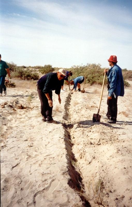
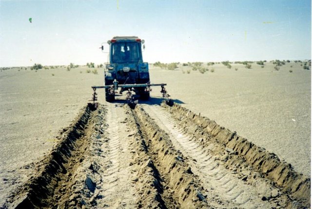
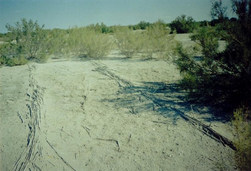
In Syrdarya river’s delta on alluvial drought sandy and loam sand soils processes of wind and water erosion become more active with a view of protection of the soils it is applied covering fascine made from a local cane or reed. Fascines thickness 12-15 cm settle down on a surface by lines in a 2-3 m. On distance of 20 centimeters it is carried out planting of a saxaul seedlings
-Planting of the saplings was done in holes and uninterrupted furrows, which were formed by hands.
-Depth of holes and furrows is 20-25 cm.
-Distance between holes was 1.5-2 m.
-Furrows were perpendicular to the prevailing winds (west-east) and placing mould in several optio0ns: 1- moulds on both sides; 2- the same from the southern side of a furrow; 3- the same from the northern side. Furrows alternated with holes rows.
-Length of rows variants in repetition was 100 m.
-Saplings were filled up by hands in rows in 1-2 meters, distance between rows was 2-2.5 meters.
Prevention of water and wind erosion on sandy and loamy sand soils of the Syrdarya delta.
Many farmers use the given technology for prevention of wind and water erosion on the lands.
The technology is applied on the area of 1.5 sq.km. Expenses per 1 ha make 99.2 $ USA or 14880 tenge.
Irrevocable water consumption in agricultural land use in the Syrdarya delta, development of the areas of irrigation, livestock grazing led to the contradiction between the agricultural industry and the ecological state of the region. It caused more intense processes of desertification, among them are soil salification and increase in the groundwater mineralization: degradation of vegetation cover; erosion and soil deflation; wind-blowing of the salts from dried bed of the Aral Sea; sand advance on the arable land, etc. At present about of 60% of irrigated areas within the Syrdarya delta are strongly salificated.
2.3 Photos of the Technology
Media Gallery
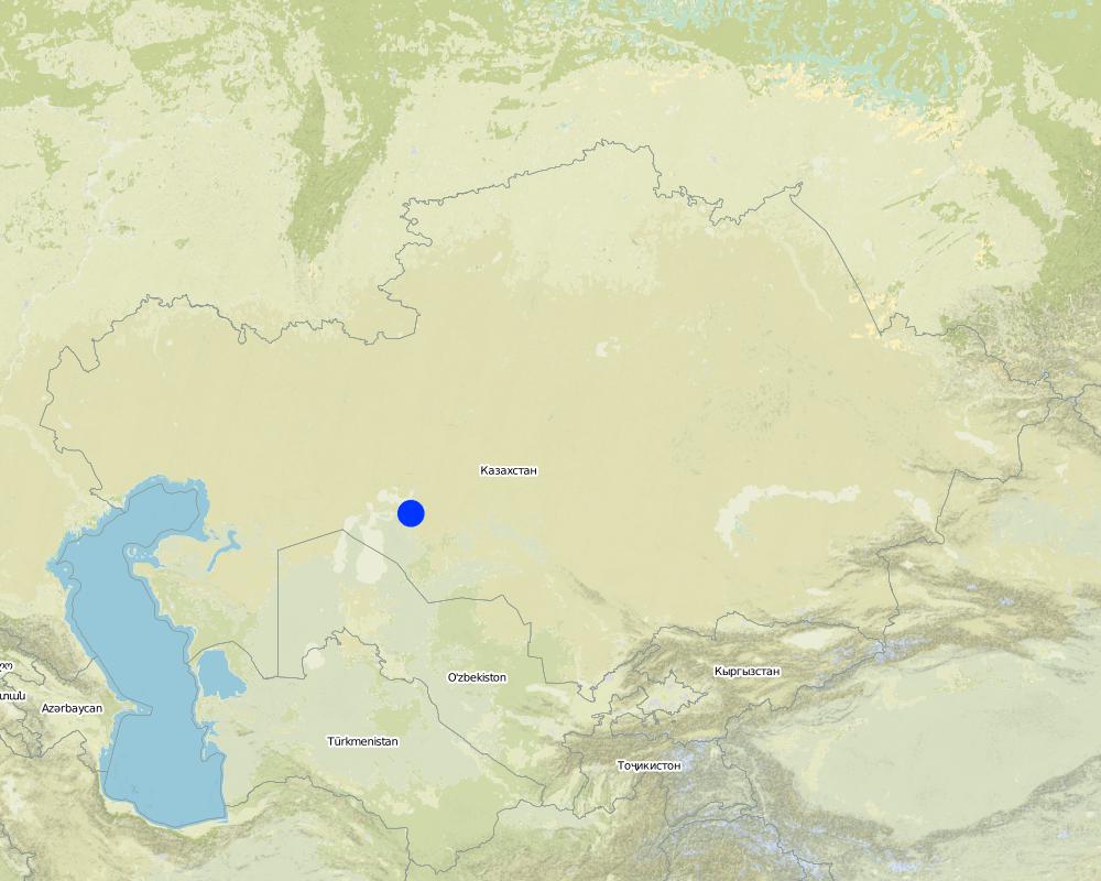
2.5 Country/ region/ locations where the Technology has been applied and which are covered by this assessment
Country:
Kazakhstan
Region/ State/ Province:
Kyzylorda oblast
Further specification of location:
Kazalinsk
Specify the spread of the Technology:
- evenly spread over an area
If the Technology is evenly spread over an area, specify area covered (in km2):
3.5
If precise area is not known, indicate approximate area covered:
- 1-10 km2
Comments:
Total area covered by the SLM Technology is 3.5 km2.
Loamy sand and sandy alluvial desertification soils of delta of the river Syrdarya are subject to process of wind erosion Deflation-accumulative prosses create threat for settlement
Map
×2.6 Date of implementation
If precise year is not known, indicate approximate date:
- less than 10 years ago (recently)
2.7 Introduction of the Technology
Specify how the Technology was introduced:
- during experiments/ research
Comments (type of project, etc.):
From Kazakh Research Institute of forest management at 1989-2002
3. Classification of the SLM Technology
3.1 Main purpose(s) of the Technology
- reduce, prevent, restore land degradation
- reduce risk of disasters
3.2 Current land use type(s) where the Technology is applied
Land use mixed within the same land unit:
Yes
Specify mixed land use (crops/ grazing/ trees):
- Agro-silvopastoralism

Cropland
- Annual cropping
- Tree and shrub cropping
Annual cropping - Specify crops:
- cereals - maize
- cereals - rice (upland)
Tree and shrub cropping - Specify crops:
- fodder trees (Calliandra, Leucaena leucocephala, Prosopis, etc.)
- Saxaul (cf. Haloxylon ammodendron)
Number of growing seasons per year:
- 2
Specify:
Longest growing period in days: 208; Longest growing period from month to month: Apr - Oct

Grazing land
Extensive grazing:
- Semi-nomadic pastoralism

Forest/ woodlands
Products and services:
- Fuelwood
Comments:
Trees/ shrubs species: saxaul seedling
Grass species: prostrate summer cypress, winterfat, corn
Major land use problems (compiler’s opinion): Loss of biological variety, degrodation of lands for agriculturing
Major land use problems (land users’ perception): Approach of sand to settlements and agricultural grounds
Grazingland comments: With a transitional economy and absence of market relations it is prevail a fine farms with a small amount of cattle on a farmstead
Type of grazing system comments: With a transitional economy and absence of market relations it is prevail a fine farms with a small amount of cattle on a farmstead
Constraints of mines and extractive industries: old system of landed property
Livestock in deltoid meadows
3.4 Water supply
Water supply for the land on which the Technology is applied:
- rainfed
3.5 SLM group to which the Technology belongs
- windbreak/ shelterbelt
- improved ground/ vegetation cover
3.6 SLM measures comprising the Technology

vegetative measures
- V1: Tree and shrub cover

structural measures
- S3: Graded ditches, channels, waterways
Comments:
Secondary measures: structural measures
Type of vegetative measures: aligned: -against wind
3.7 Main types of land degradation addressed by the Technology

soil erosion by water
- Wt: loss of topsoil/ surface erosion

soil erosion by wind
- Et: loss of topsoil
Comments:
Secondary types of degradation addressed: Wt: loss of topsoil / surface erosion
Main causes of degradation: other human induced causes (specify) (agricultural causes - Excessive water-fence on an irrigation from the rivers Syrdarya and Amurdarya.)
Secondary causes of degradation: deforestation / removal of natural vegetation (incl. forest fires) (Destraction saxaul fuel.), other natural causes (avalanches, volcanic eruptions, mud flows, highly susceptible natural resources, extreme topography, etc.) specify (High wind activity in region (prevalence of winds with a speed up to 5 min/sec).)
3.8 Prevention, reduction, or restoration of land degradation
Specify the goal of the Technology with regard to land degradation:
- prevent land degradation
- restore/ rehabilitate severely degraded land
4. Technical specifications, implementation activities, inputs, and costs
4.1 Technical drawing of the Technology
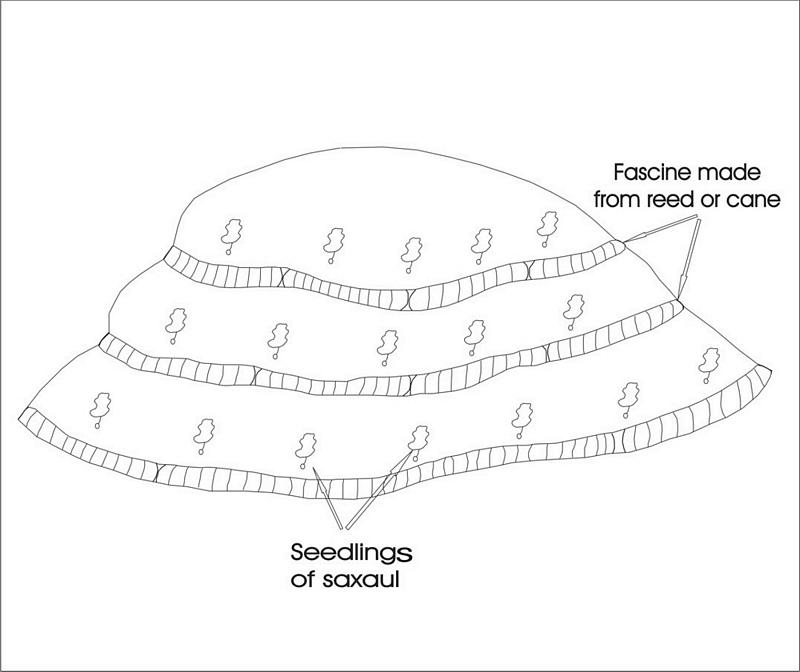
Technical specifications (related to technical drawing):
Ameliorative plantings
Technical knowledge required for field staff / advisors: low
Technical knowledge required for land users: low
Main technical functions: reduction in wind speed
Aligned: -against wind
Vegetative material: T : trees / shrubs, G : grass
Number of plants per (ha): 3000
Vertical interval between rows / strips / blocks (m): 2
Spacing between rows / strips / blocks (m): 2
Vertical interval within rows / strips / blocks (m): 1,5
Width within rows / strips / blocks (m): 0,2
Trees/ shrubs species: saxaul seedling
Grass species: prostrate summer cypress, winterfat, corn
Dam/ pan/ pond
Vertical interval between structures (m): 2
Spacing between structures (m): 2
Height of bunds/banks/others (m): 0,05
Width of bunds/banks/others (m): 0,5
Length of bunds/banks/others (m): 100
Construction material (other): Reed fascines
4.2 General information regarding the calculation of inputs and costs
Specify currency used for cost calculations:
- USD
Indicate average wage cost of hired labour per day:
5.00
4.3 Establishment activities
| Activity | Timing (season) | |
|---|---|---|
| 1. | Stacking of fascines | summer |
| 2. | Slips' planting | autumn, spring |
| 3. | Laying fascines | summer |
| 4. | Slips' planting | spring, autumn |
4.4 Costs and inputs needed for establishment
| Specify input | Unit | Quantity | Costs per Unit | Total costs per input | % of costs borne by land users | |
|---|---|---|---|---|---|---|
| Labour | Labour | persons/day/ha | 3.0 | 5.0 | 15.0 | 100.0 |
| Equipment | Machine use | ha | 1.0 | 20.0 | 20.0 | 100.0 |
| Equipment | Tools | ha | 1.0 | 10.0 | 10.0 | 100.0 |
| Plant material | Seedlings | ha | 1.0 | 165.0 | 165.0 | 100.0 |
| Construction material | Other | ha | 1.0 | 10.0 | 10.0 | 100.0 |
| Total costs for establishment of the Technology | 220.0 | |||||
| Total costs for establishment of the Technology in USD | 220.0 | |||||
Comments:
Duration of establishment phase: 24 month(s)
4.5 Maintenance/ recurrent activities
| Activity | Timing/ frequency | |
|---|---|---|
| 1. | Additional planting | spring /1 |
| 2. | Supplementary slips' planting | spring, autumn/1 |
| 3. | Supplementary fascines' setting | spring, autumn/1 |
4.6 Costs and inputs needed for maintenance/ recurrent activities (per year)
Comments:
Reed fascines against deflation 100 m in length, 0,5 m in breadth 50 pieces per ha
Saxaul’s seedling every 2 m lines, distance between slips-1.5 m, 3300 pieces per ha
4.7 Most important factors affecting the costs
Describe the most determinate factors affecting the costs:
Manufacturing of reed fascines, purchase and planting saxaul's seedlinfs
5. Natural and human environment
5.1 Climate
Annual rainfall
- < 250 mm
- 251-500 mm
- 501-750 mm
- 751-1,000 mm
- 1,001-1,500 mm
- 1,501-2,000 mm
- 2,001-3,000 mm
- 3,001-4,000 mm
- > 4,000 mm
Specify average annual rainfall (if known), in mm:
124.00
Agro-climatic zone
- arid
Deserted
5.2 Topography
Slopes on average:
- flat (0-2%)
- gentle (3-5%)
- moderate (6-10%)
- rolling (11-15%)
- hilly (16-30%)
- steep (31-60%)
- very steep (>60%)
Landforms:
- plateau/plains
- ridges
- mountain slopes
- hill slopes
- footslopes
- valley floors
Altitudinal zone:
- 0-100 m a.s.l.
- 101-500 m a.s.l.
- 501-1,000 m a.s.l.
- 1,001-1,500 m a.s.l.
- 1,501-2,000 m a.s.l.
- 2,001-2,500 m a.s.l.
- 2,501-3,000 m a.s.l.
- 3,001-4,000 m a.s.l.
- > 4,000 m a.s.l.
Comments and further specifications on topography:
Altitudinal zone: 58-53 m abs. of hight
Landforms: Poorly wavy inclined plan
Slopes on average: Weakly wavy
5.3 Soils
Soil depth on average:
- very shallow (0-20 cm)
- shallow (21-50 cm)
- moderately deep (51-80 cm)
- deep (81-120 cm)
- very deep (> 120 cm)
Soil texture (topsoil):
- coarse/ light (sandy)
- medium (loamy, silty)
Topsoil organic matter:
- low (<1%)
If available, attach full soil description or specify the available information, e.g. soil type, soil PH/ acidity, Cation Exchange Capacity, nitrogen, salinity etc.
Soil depth on average: Depth of humus under 5sm
Soil fertility is very low 0,191 of humus
Topsoil organic matter: 0,13-0,26%
Soil drainage / infiltration is good ins sandy and loamy soils and medium in clay
Soil water storage capacity is very low - low
5.6 Characteristics of land users applying the Technology
Market orientation of production system:
- mixed (subsistence/ commercial)
Off-farm income:
- less than 10% of all income
Relative level of wealth:
- very poor
- poor
Level of mechanization:
- manual work
Indicate other relevant characteristics of the land users:
Annual population growth: negative
20% of the land users are average wealthy and own 60% of the land.
20% of the land users are poor and own 20% of the land.
60% of the land users are poor and own 20% of the land.
Off-farm income specification: With falling a level of Aral sea and degradation of the natural invironment in dicline there came all branches of agriculture and fishing industry
Level of mechanization: Fascines and planting of bushes are manually spread
Market orientation of production system: Rise of pastures' fodder capacity
5.7 Average area of land used by land users applying the Technology
- < 0.5 ha
- 0.5-1 ha
- 1-2 ha
- 2-5 ha
- 5-15 ha
- 15-50 ha
- 50-100 ha
- 100-500 ha
- 500-1,000 ha
- 1,000-10,000 ha
- > 10,000 ha
5.8 Land ownership, land use rights, and water use rights
Land ownership:
- state
Land use rights:
- communal (organized)
- individual
6. Impacts and concluding statements
6.1 On-site impacts the Technology has shown
Socio-economic impacts
Production
crop production
Comments/ specify:
The projective covering increases
Income and costs
farm income
Comments/ specify:
Increase in effeciency of livestock
workload
Comments/ specify:
Manual labour
Other socio-economic impacts
Fastening of surface
Comments/ specify:
Stoppage of blowing
Socio-cultural impacts
community institutions
Comments/ specify:
Increase of farmer's living level
Ecological impacts
Soil
soil cover
Comments/ specify:
Surface stabilization
soil loss
Comments/ specify:
Blowing stops
Climate and disaster risk reduction
wind velocity
Comments/ specify:
Times are occupied
Other ecological impacts
biodiversity
6.2 Off-site impacts the Technology has shown
wind transported sediments
Comments/ specify:
Erosion of surface of the ground are stopping
6.4 Cost-benefit analysis
How do the benefits compare with the establishment costs (from land users’ perspective)?
Long-term returns:
slightly positive
How do the benefits compare with the maintenance/ recurrent costs (from land users' perspective)?
Long-term returns:
slightly positive
6.5 Adoption of the Technology
- 11-50%
If available, quantify (no. of households and/ or area covered):
15 households covering 20 percent of stated area
Of all those who have adopted the Technology, how many did so spontaneously, i.e. without receiving any material incentives/ payments?
- 91-100%
Comments:
15 land user families have adopted the Technology without any external material support
Comments on spontaneous adoption: survey results
There is a moderate trend towards spontaneous adoption of the Technology
Comments on adoption trend: The increase of deflated and eroded areas compels farmers to apply SWC
6.7 Strengths/ advantages/ opportunities of the Technology
| Strengths/ advantages/ opportunities in the land user’s view |
|---|
|
Decrease in the areas of wind and water erosion How can they be sustained / enhanced? For a long time enough depending on life cycle of wood-bushes vegetation |
|
Improvement of microclimatic conditions of settlements How can they be sustained / enhanced? During all time of existence of the green zone created with the help of SWC |
| Strengths/ advantages/ opportunities in the compiler’s or other key resource person’s view |
|---|
|
Stabilization of mobile sand How can they be sustained / enhanced? At rational use of technology the created ecosystem can be supported for some life cycles with help of the main wood breed |
| Elimination of drifts of settlements by sand |
| Returning the grounds in rotation of the pasture |
| Creation of additional workplaces |
6.8 Weaknesses/ disadvantages/ risks of the Technology and ways of overcoming them
| Weaknesses/ disadvantages/ risks in the land user’s view | How can they be overcome? |
|---|---|
| Shortage of seedlings for the big areas | Creation of artificial nurseries |
| Weaknesses/ disadvantages/ risks in the compiler’s or other key resource person’s view | How can they be overcome? |
|---|---|
| Almost hundred percentage use of manual skills | Development of new machines and mechanisms |
| Probably low survival of seedlings and absence of shoots because the weather conditions are not good enough | The organization of post planting watering |
7. References and links
7.1 Methods/ sources of information
7.2 References to available publications
Title, author, year, ISBN:
"To develop scientific bases of forest amelioration of the grounds of a naked bottom of Aral sea, classification of types of growth conditions" Kaverin V.S.. 2000y.
Available from where? Costs?
SPC for forest facility58 Kirov str. Shuchinsk cityAkmola regionThe Republic of Kazakhstan
Links and modules
Expand all Collapse allLinks
The approach of groove fastening sandy loam and … [Kazakhstan]
The approach of groove fastening sandy-loam and sandy soils of the Aral sea's drained bottom
- Compiler: Vladimir Kaverin
Modules
No modules