Afforestation [Cape Verde]
- Creation:
- Update:
- Compiler: Jacques Tavares
- Editor: –
- Reviewers: Deborah Niggli, Alexandra Gavilano
Arborização / floresta (Portuguese)
technologies_1523 - Cape Verde
View sections
Expand all Collapse all1. General information
1.2 Contact details of resource persons and institutions involved in the assessment and documentation of the Technology
SLM specialist:
Varela Larissa
INIDA
Cape Verde
SLM specialist:
Amarós Regla
INIDA
Cape Verde
SLM specialist:
Bentub Jailson
INIDA
Cape Verde
Name of project which facilitated the documentation/ evaluation of the Technology (if relevant)
DESIRE (EU-DES!RE)Name of the institution(s) which facilitated the documentation/ evaluation of the Technology (if relevant)
INIDA (INIDA) - Cape Verde1.3 Conditions regarding the use of data documented through WOCAT
The compiler and key resource person(s) accept the conditions regarding the use of data documented through WOCAT:
Yes
1.4 Declaration on sustainability of the described Technology
Is the Technology described here problematic with regard to land degradation, so that it cannot be declared a sustainable land management technology?
No
1.5 Reference to Questionnaire(s) on SLM Approaches (documented using WOCAT)

Protection des versants [Cape Verde]
Cette approche consiste à mettre à profit les eaux d'écoulement superficiel
- Compiler: Jacques Tavares
2. Description of the SLM Technology
2.1 Short description of the Technology
Definition of the Technology:
Afforestation is one of the key technologies to address the fragility of ecosystems: it provides better protection against erosion and makes better use of rainfall in order to maintain the sustainability of agricultural systems.
2.2 Detailed description of the Technology
Description:
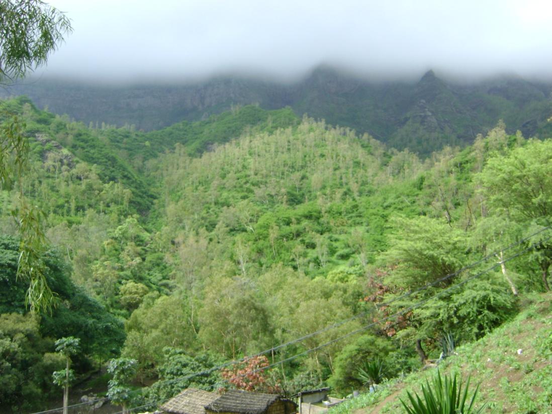
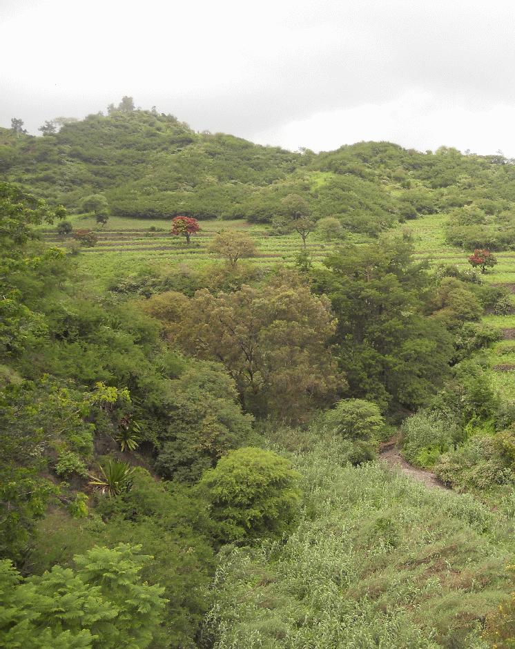
Mountain forest areas are considered protective due to their role in regulating water (infiltration of storm water, regulation of surface runoff, and ground water recharge) within the watershed. The main species used are Prosopis juliflora, Parkinsonia aculeata, Jatropha curcas, Atriplex spp, Acacia holosericea, Acacia victoriae, Lantana camara and others, in arid areas and Eucalyptus camaldulensis, Grevillea robusta, Pinus and Cupressus ssp. in highland and humid areas.
Purpose of the Technology: The climatic conditions are characterized by high spatial and temporal variability of the rainfall. The rains are concentrated in two or three months (August and September or October); the highlands and the N-NE parts are wetter compared to the low lands or coastal areas, which are very dry. The average annual rainfall is about 225 mm over the whole island; it has declined since the 1960s, with negative effects on farming conditions, and water supply. However, in areas located more than 500 m above sea level and exposed to trade winds, rainfall can exceed 700 mm. About 20% of the precipitation is lost through runoff, 13% infiltrates the soil and recharges aquifers and 67% evaporates. The evaporation loss is a limiting factor for any agriculture or forestry. Therefore, it is necessary to adapt the afforestation implementation to the specific local conditions (slope, stone cover, climate, etc). To overcome and minimize the problem of water scarcity, several measures are applied: (a) caldeira or half-moon structures achieved with earth or stone; (b) contour furrows or level bench terraces with stone walls arranged along the contour; (c). small dams to protect gullies. The aim is to maximize retention of water and control surface runoff. This not only allows better infiltration of water for the tree plantations, but also protects against soil erosion and facilitates groundwater recharge.
Establishment / maintenance activities and inputs: The success of the reforestation may be indicated not only by the area covered but also by the number of introduced plants. In 1975, there were about 3,000 ha of afforested land. By 2011, there are over 90,000 ha of afforested land with almost 50 million trees. Afforestation has focused mainly on the island of Santiago and Santo Antão, (13% of the total area reforested). Nowadays, more than 20% of the country is afforested. The forest has had a great importance in the context of combating desertification, rehabilitation of vegetation cover, in meeting energy needs and forage production and in developing agrosilvopastoral systems, as well as having undoubtedly contributed to a significant modification of the landscape in Cape Verde. The afforestation activities also contributed to increase biodiversity of some species of birds, including “Galinha di mato” (Numida meleagris), “Codorniz” (Coturnix coturnix), “Passarinha” (Halcyon leucocephala) and others.
Natural / human environment: The forest species are mainly used for land protection and for production of fuel wood and coal. Because of the poor growing conditions, the forest species are not well suited to the construction industry or wood processing.
2.3 Photos of the Technology
Media Gallery
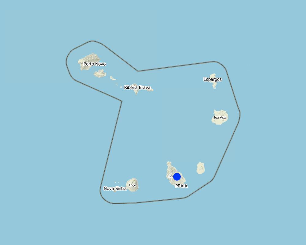
2.5 Country/ region/ locations where the Technology has been applied and which are covered by this assessment
Country:
Cape Verde
Region/ State/ Province:
Santiago Island, Cape Verde
Further specification of location:
Ribeira Seca
Specify the spread of the Technology:
- evenly spread over an area
If the Technology is evenly spread over an area, specify area covered (in km2):
71.5
Comments:
Total area covered by the SLM Technology is 71.5 km2
The forest with the greatest density of trees occupies an area of 2.51 km2 and is located in the area of higher altitude. The density decreases with decrease in altitude
Map
×2.6 Date of implementation
If precise year is not known, indicate approximate date:
- 10-50 years ago
2.7 Introduction of the Technology
Specify how the Technology was introduced:
- through projects/ external interventions
Comments (type of project, etc.):
Before 1975, the forestry production was directed to the market of wood, after 1975 began to stock in order to protect the environment
3. Classification of the SLM Technology
3.1 Main purpose(s) of the Technology
- reduce, prevent, restore land degradation
- conserve ecosystem
3.2 Current land use type(s) where the Technology is applied
Land use mixed within the same land unit:
Yes
Specify mixed land use (crops/ grazing/ trees):
- Silvo-pastoralism

Grazing land
Intensive grazing/ fodder production:
- Cut-and-carry/ zero grazing
Animal type:
- goats
- cows

Forest/ woodlands
- Tree plantation, afforestation
Tree plantation, afforestation: Specify origin and composition of species:
- Mixed varieties
Type of tree plantation, afforestation:
- tropical mountain systems plantation - Eucalyptus spp.
- tropical mountain systems plantation - Pinus spp.
Type of tree:
- Acacia species
- Cupressus species
- Eucalyptus camaldulensis
- Grevillea robusta
- Pinus species
- Prosopis juliflora, Parkinsonia aculeata, Jatropha curcas, Atriplex spp, Lantana camara
Products and services:
- Nature conservation/ protection
Comments:
Major land use problems (compiler’s opinion): The loss of soil by runoff, influenced by its low coverage, reducing their fertility and their thickness
Major land use problems (land users’ perception): Soil erosion by runoff, low productive soils, low organic matter, low soil cover, fertility and depth particularly in the agro-systems with rainfed agriculture.
Cut-and-carry/ zero grazing: goats/ cows
Grazingland comments: production is characterized as extensive, although made in a closed expaço
Plantation forestry: Few trees are cut, since the main objective of which is the forest canopy. The dead are removed, make's some clean and plant new trees every year.
Problems / comments regarding forest use: Before 1975, date of independence of Cape Verde, began to stock the areas discovered. The forest is more dense at high altitudes but also introduced
Forest products and services: nature conservation / protection
Future (final) land use (after implementation of SLM Technology): Mixed: Ms: Silvo-pastoralism
Type of grazing system comments: production is characterized as extensive, although made in a closed expaço
Number of growing seasons per year: 1
Longest growing period in days: 90
Longest growing period from month to month: August untill October
Livestock density : 25-50 LU /km2
The main species used are Prosopis juliflora, Parkinsonia aculeata, Jatropha curcas, Atriplex spp, Acacia holosericea, Acacia victoriae, Lantana camara and others, in arid areas and Eucalyptus camaldulensis, Grevillea robusta, Pinus and Cupressus ssp. in highland and humid areas.
3.3 Has land use changed due to the implementation of the Technology?
Has land use changed due to the implementation of the Technology?
- Yes (Please fill out the questions below with regard to the land use before implementation of the Technology)

Other
3.4 Water supply
Water supply for the land on which the Technology is applied:
- rainfed
3.5 SLM group to which the Technology belongs
- natural and semi-natural forest management
- irrigation management (incl. water supply, drainage)
3.6 SLM measures comprising the Technology

vegetative measures
- V1: Tree and shrub cover

structural measures
- S2: Bunds, banks
Comments:
Secondary measures: structural measures
3.7 Main types of land degradation addressed by the Technology

soil erosion by water
- Wt: loss of topsoil/ surface erosion
- Wg: gully erosion/ gullying

biological degradation
- Bc: reduction of vegetation cover
- Bh: loss of habitats

water degradation
- Hg: change in groundwater/aquifer level
Comments:
Secondary types of degradation addressed: Hg: change in groundwater / aquifer level
Main causes of degradation: soil management (It is cultivated maize and peanuts on land slopes very pronounced and boot up the plants by the root in end of the cycle), crop management (annual, perennial, tree/shrub) (The cleaning of the crop residues of corn is done pulling them by the root, negatively affecting soil stability), poverty / wealth (Leads sensitized peoples to advocate action against the landscape for survival of the family), education, access to knowledge and support services (Knowledge and technical training increase the options for means of survival of the community that acts on the forest, the degree of attending school is low and the illiteracy rate is 17%)
Secondary causes of degradation: overgrazing (Creation of the wild animals compact the soil, destroying the structures for the conservation of soil and water exists, and creates conflict), disturbance of water cycle (infiltration / runoff), Heavy / extreme rainfall (intensity/amounts) (Sometimes occur heavy rains intensity that associated with poor vegetation cover, increase soil erosion), governance / institutional (Lack of applicability of the laws that manage the land)
3.8 Prevention, reduction, or restoration of land degradation
Specify the goal of the Technology with regard to land degradation:
- restore/ rehabilitate severely degraded land
4. Technical specifications, implementation activities, inputs, and costs
4.1 Technical drawing of the Technology
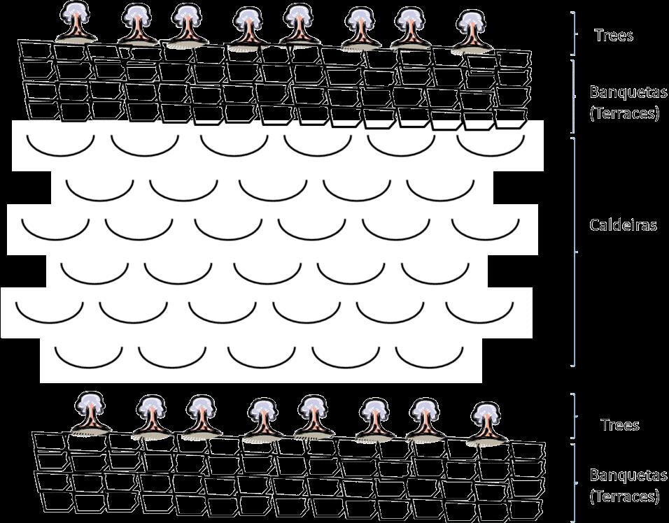
Technical specifications (related to technical drawing):
Treatment of slope before afforestation
Technical knowledge required for field staff / advisors: moderate (It's needed sufficient knowledge to choice species according to their suitability to the natural and human environment)
Technical knowledge required for land users: low
Main technical functions: control of raindrop splash, improvement of ground cover, stabilisation of soil (eg by tree roots against land slides), increase of infiltration, increase of groundwater level / recharge of groundwater
Secondary technical functions: increase in organic matter, increase / maintain water stored in soil, reduction in wind speed
Retention/infiltration ditch/pit, sediment/sand trap
Vertical interval between structures (m): 2
Spacing between structures (m): 5
Depth of ditches/pits/dams (m): 0.2
Width of ditches/pits/dams (m): 0.8
Length of ditches/pits/dams (m): 100
Height of bunds/banks/others (m): 0.4
Width of bunds/banks/others (m): 0.4
Length of bunds/banks/others (m): 100
Construction material (earth): land from the local construction of the ditch is used in the construction of banks, that can be rein
Slope (which determines the spacing indicated above): 30 - 60%
Lateral gradient along the structure: 0%
For water harvesting: the ratio between the area where the harvested water is applied and the total area from which water is collected is: 1:3
Vegetation is used for stabilisation of structures.
Author:
Jacques Tavares
4.3 Establishment activities
| Activity | Timing (season) | |
|---|---|---|
| 1. | Quantification of the area to be afforested | |
| 2. | Production of plants in nursery ( 500 - 1300 plants) | |
| 3. | Treatment of area (slope) with building terraces (15 m / person / day) | |
| 4. | Treatment of area (slope) with: Making half-moons “Caldeiras” (3 / person / day) | |
| 5. | 4.Excavating the pits (10 / person / day): 60x60x60 cm | |
| 6. | Planting (50 /person / day): 5 to 5 metres | |
| 7. | Initial maintenance (8 /persons / day) | |
| 8. | Cleaning and marking on curves level | In April |
| 9. | Construction of the retention / infiltration ditch and opening of the surface of culture | April to June |
4.4 Costs and inputs needed for establishment
| Specify input | Unit | Quantity | Costs per Unit | Total costs per input | % of costs borne by land users | |
|---|---|---|---|---|---|---|
| Labour | Labour | ha | 1.0 | 28218.0 | 28218.0 | |
| Equipment | Tools | ha | 1.0 | 410.0 | 410.0 | 10.0 |
| Plant material | Seeds | ha | 1.0 | 942.0 | 942.0 | |
| Total costs for establishment of the Technology | 29570.0 | |||||
| Total costs for establishment of the Technology in USD | 29570.0 | |||||
Comments:
Duration of establishment phase: 1 month(s)
4.5 Maintenance/ recurrent activities
| Activity | Timing/ frequency | |
|---|---|---|
| 1. | forest cleaning | |
| 2. | forest cleaning | In the dry session |
4.6 Costs and inputs needed for maintenance/ recurrent activities (per year)
| Specify input | Unit | Quantity | Costs per Unit | Total costs per input | % of costs borne by land users | |
|---|---|---|---|---|---|---|
| Labour | Forest cleaning | ha | 1.0 | 142.0 | 142.0 | 52.0 |
| Total costs for maintenance of the Technology | 142.0 | |||||
| Total costs for maintenance of the Technology in USD | 142.0 | |||||
Comments:
Machinery/ tools: Hoe, machete
Costs are estimated according to the time required for afforestation and the entity contracted for the implementation of the activities.
4.7 Most important factors affecting the costs
Describe the most determinate factors affecting the costs:
The labour affects the costs more than other factors. Paid labour is a way to achieve additional income for many people in this area. The employer (Directorate General of Agriculture, Sylviculture and Livestock of the Ministry of Rural Development) provides 90% of the cost of the equipment. The lifetime of the equipment is 10-15 years.
5. Natural and human environment
5.1 Climate
Annual rainfall
- < 250 mm
- 251-500 mm
- 501-750 mm
- 751-1,000 mm
- 1,001-1,500 mm
- 1,501-2,000 mm
- 2,001-3,000 mm
- 3,001-4,000 mm
- > 4,000 mm
Specify average annual rainfall (if known), in mm:
800.00
Agro-climatic zone
- humid
- sub-humid
- semi-arid
- arid
Thermal climate class: tropics. average temperature equal to 26 º C
The exposure and altitude are factors diterminantes for agroclimatic estratização. the higher areas and targeted to the SE are more humid.
5.2 Topography
Slopes on average:
- flat (0-2%)
- gentle (3-5%)
- moderate (6-10%)
- rolling (11-15%)
- hilly (16-30%)
- steep (31-60%)
- very steep (>60%)
Landforms:
- plateau/plains
- ridges
- mountain slopes
- hill slopes
- footslopes
- valley floors
Altitudinal zone:
- 0-100 m a.s.l.
- 101-500 m a.s.l.
- 501-1,000 m a.s.l.
- 1,001-1,500 m a.s.l.
- 1,501-2,000 m a.s.l.
- 2,001-2,500 m a.s.l.
- 2,501-3,000 m a.s.l.
- 3,001-4,000 m a.s.l.
- > 4,000 m a.s.l.
Indicate if the Technology is specifically applied in:
- not relevant
Comments and further specifications on topography:
Altitudinal zone: 100-500 m a.s.l. belongs to the stratum semi-arid sub-humid. Is part of the stratum the highest percentage of the area of the basin. 1000-1500 m a.s.l. includes mainly the cliffs and ridges.
Landforms: Also ridges and footslopes. The hazards of a convex situations does not allow its application in mountain slopes.
5.3 Soils
Soil depth on average:
- very shallow (0-20 cm)
- shallow (21-50 cm)
- moderately deep (51-80 cm)
- deep (81-120 cm)
- very deep (> 120 cm)
Soil texture (topsoil):
- coarse/ light (sandy)
- medium (loamy, silty)
Topsoil organic matter:
- medium (1-3%)
- low (<1%)
If available, attach full soil description or specify the available information, e.g. soil type, soil PH/ acidity, Cation Exchange Capacity, nitrogen, salinity etc.
Soil depth on average: Very shallow is associated with the sloping hillsides used for rainfull agriculture and shaloow is found mainly in the valley bottoms of the downstream.
Soil texture (topsoil): The soil overlay mainly basaltic rocks, piroclastic, conglomerates and aluvial deposits
Soil fertility is medium - low
Soil drainage / infiltration is good - medium
Soil water storage capacity is medium - low
5.4 Water availability and quality
Ground water table:
5-50 m
Availability of surface water:
poor/ none
Water quality (untreated):
poor drinking water (treatment required)
Comments and further specifications on water quality and quantity:
Ground water table: In rain months, it is more superficial than in the dry months
Availability of surface water: There is some just when it rains.
Water quality (untreated): Salinization of water due to over exploitation of wells and boreholes
5.5 Biodiversity
Species diversity:
- medium
5.6 Characteristics of land users applying the Technology
Off-farm income:
- less than 10% of all income
Relative level of wealth:
- poor
Individuals or groups:
- employee (company, government)
Indicate other relevant characteristics of the land users:
Population density: 100-200 persons/km2
Annual population growth: > 4%
and own 1% of the land (the tecnology is applyed by the state, and the state of that country is poor).
Off-farm income specification: forest production (mainly grass and wood) generate an annual income of approximately $2,500
Market orientation of production system: Mixed:Forest products are quite limited: lumber, firewood, charcoal and fodder from the pods. Firewood is the most important product but marketing is quite limited in time and space and subsistence are families who enter the forest for collection of grass and firewood. It is necessary for their survival. The state sells these products in order to finance other development projects.
5.7 Average area of land used by land users applying the Technology
- < 0.5 ha
- 0.5-1 ha
- 1-2 ha
- 2-5 ha
- 5-15 ha
- 15-50 ha
- 50-100 ha
- 100-500 ha
- 500-1,000 ha
- 1,000-10,000 ha
- > 10,000 ha
Is this considered small-, medium- or large-scale (referring to local context)?
- large-scale
Comments:
Also 50-100 ha, 100-500 ha and 100-500 ha,
The forest covers all the household
The grass production is made between the trees across the forest area if it's possible
5.8 Land ownership, land use rights, and water use rights
Land ownership:
- state
- individual, titled
- Diocese
Land use rights:
- communal (organized)
- individual
Water use rights:
- communal (organized)
5.9 Access to services and infrastructure
education:
- poor
- moderate
- good
technical assistance:
- poor
- moderate
- good
employment (e.g. off-farm):
- poor
- moderate
- good
markets:
- poor
- moderate
- good
energy:
- poor
- moderate
- good
roads and transport:
- poor
- moderate
- good
drinking water and sanitation:
- poor
- moderate
- good
financial services:
- poor
- moderate
- good
6. Impacts and concluding statements
6.1 On-site impacts the Technology has shown
Socio-economic impacts
Production
fodder production
fodder quality
energy generation
Comments/ specify:
Firewood to the community
Water availability and quality
drinking water availability
Income and costs
expenses on agricultural inputs
economic disparities
Socio-cultural impacts
food security/ self-sufficiency
Comments/ specify:
It reduces the options of land use
cultural opportunities
conflict mitigation
situation of socially and economically disadvantaged groups
Comments/ specify:
Any sex has the same opportunity on the assets of the forest
livelihood and human well-being
Comments/ specify:
It improves air quality, promotes the production of endemic species and its use as medicine
Ecological impacts
Water cycle/ runoff
groundwater table/ aquifer
evaporation
Soil
soil moisture
soil cover
soil loss
soil organic matter/ below ground C
Climate and disaster risk reduction
emission of carbon and greenhouse gases
wind velocity
Other ecological impacts
Invasive species
competition
6.2 Off-site impacts the Technology has shown
water availability
reliable and stable stream flows in dry season
downstream flooding
downstream siltation
buffering/ filtering capacity
wind transported sediments
damage on neighbours' fields
6.3 Exposure and sensitivity of the Technology to gradual climate change and climate-related extremes/ disasters (as perceived by land users)
Gradual climate change
Gradual climate change
| Season | increase or decrease | How does the Technology cope with it? | |
|---|---|---|---|
| annual temperature | increase | well |
Climate-related extremes (disasters)
Meteorological disasters
| How does the Technology cope with it? | |
|---|---|
| local rainstorm | not known |
| local windstorm | not well |
Climatological disasters
| How does the Technology cope with it? | |
|---|---|
| drought | not well |
Hydrological disasters
| How does the Technology cope with it? | |
|---|---|
| general (river) flood | not known |
Other climate-related consequences
Other climate-related consequences
| How does the Technology cope with it? | |
|---|---|
| reduced growing period | well |
Comments:
Tree species more tolerant of the climatic factors can be used, whilst retaining all the benefits that the existing species provide
6.4 Cost-benefit analysis
How do the benefits compare with the establishment costs (from land users’ perspective)?
Short-term returns:
negative
Long-term returns:
positive
How do the benefits compare with the maintenance/ recurrent costs (from land users' perspective)?
Short-term returns:
neutral/ balanced
Long-term returns:
very positive
Comments:
The high costs are associated with its implementation; afterwards they are significantly reduced and the technology builds up the benefits.
6.5 Adoption of the Technology
If available, quantify (no. of households and/ or area covered):
None. It's a project of the government
Comments:
Comments on acceptance with external material support: Only the state has implemented this technology, because it changes the use of land and, without any subsidies, other land users are not encouraged to agree to it.
There is a moderate trend towards spontaneous adoption of the Technology
Comments on adoption trend: there is a continuing campaign of afforestation of state land. There are voluntary associations working in this technology for a better environment
6.7 Strengths/ advantages/ opportunities of the Technology
| Strengths/ advantages/ opportunities in the land user’s view |
|---|
|
Production of firewood and grass How can they be sustained / enhanced? make more forest operations such as pruning or cutting of new seedlings |
|
Protection of soil How can they be sustained / enhanced? strengthen maintenance operations |
| Strengths/ advantages/ opportunities in the compiler’s or other key resource person’s view |
|---|
|
Increases the quality of the landscape and reduces the loss of soil by runoff How can they be sustained / enhanced? increasing the tree cover in areas with low coverage |
|
Encourages the production of livestock, and fuel wood How can they be sustained / enhanced? integrate the community in managing the forest, and manage it in a sustainable way. |
6.8 Weaknesses/ disadvantages/ risks of the Technology and ways of overcoming them
| Weaknesses/ disadvantages/ risks in the land user’s view | How can they be overcome? |
|---|---|
| impossibility of farming in the forest lands | off-farm income creation to compensate |
| Lack of involvement of farmers in the management of forest areas | capacity building of land users in forest management strategies, elaboration of contracts between State and land users for the management of forest perimeters |
| Weaknesses/ disadvantages/ risks in the compiler’s or other key resource person’s view | How can they be overcome? |
|---|---|
| Reduces the percentage of land for agricultural production | increase productivity in cultivated land and reduce the need for the use of forest land, and implement new production technologies such as greenhouses |
7. References and links
7.1 Methods/ sources of information
7.2 References to available publications
Title, author, year, ISBN:
Desertification at the Santiago Island, DESIRE, 2008
Title, author, year, ISBN:
Relatório de avaliação inicial do impacto das realizações de conservação de solos e água em 1993 do projecto WDP, WDP project, 1995
Title, author, year, ISBN:
www.ine.cv: Survey of family income and expenditure, INE, 2002
Title, author, year, ISBN:
OCDE, CILSS, 1982. Análise do Sector Florestal e Propostas para Cabo Verde. Sahel D (82) 179
Available from where? Costs?
Club do Sahel, pp 203.
Title, author, year, ISBN:
MAAA/DGASP, 1996. Rapport de pays pour la Conférence Technique Internationale de la FAO sur les Ressources Phytogénétiques, Leipzig, 1996, pp 38.
Available from where? Costs?
Leipzig, 1996, pp 38.
Links and modules
Expand all Collapse allLinks
Protection des versants [Cape Verde]
Cette approche consiste à mettre à profit les eaux d'écoulement superficiel
- Compiler: Jacques Tavares
Modules
No modules