Reforced terraces for stone walls [Cape Verde]
- Creation:
- Update:
- Compiler: Jacques Tavares
- Editor: –
- Reviewers: Fabian Ottiger, Alexandra Gavilano
Terraços reforçados por murros de pedra
technologies_1573 - Cape Verde
View sections
Expand all Collapse all1. General information
1.2 Contact details of resource persons and institutions involved in the assessment and documentation of the Technology
Key resource person(s)
SLM specialist:
SLM specialist:
Gomes Samuel
INIDA
Cape Verde
SLM specialist:
Varela Larissa
INIDA
Cape Verde
SLM specialist:
Bentub Jailson
INIDA
Cape Verde
1.3 Conditions regarding the use of data documented through WOCAT
The compiler and key resource person(s) accept the conditions regarding the use of data documented through WOCAT:
Yes
1.4 Declaration on sustainability of the described Technology
Is the Technology described here problematic with regard to land degradation, so that it cannot be declared a sustainable land management technology?
No
1.5 Reference to Questionnaire(s) on SLM Approaches (documented using WOCAT)
Arborisation [Cape Verde]
No description available.
- Compiler: Jacques Tavares
2. Description of the SLM Technology
2.1 Short description of the Technology
Definition of the Technology:
Platforms created in series along the slopes, separated by punch of stone, vertical, reduced the length of slopes and facilitating the infiltration of water and increasing production
2.2 Detailed description of the Technology
Description:
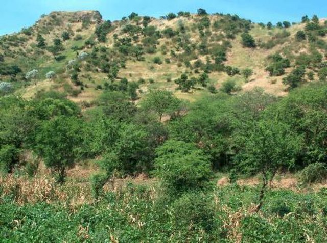
The terraces, platforms are created on the slopes, where the slope exceeds 30, to reduce or eliminate the gradient of the slope, creating an agricultural field with better soil fertility. Such platforms have 5% inclination to the inside retaining more water to its surface, and 1% of the drainage along facit, in case of saturation of soil in water. The separation between two platforms is performed by punches from the local stone, that structure has to be calculated, taking into cosideração the slope of the slope, the width of the platform, edefoclimáticas conditions and other variables.
Its primary objective is to adapt the land to use it intends to take to eliminate the slope of the hill, working to increase soil moisture, the reduction of runoff, and its kinetic energy through the punches
Implementation: Need wide availability of labor and large technical training for its implementation. The activity of implementation requires the calculation of the volume of soil to be moved, thus defining the width of the platform, this volume that depends crucially on the thickness of surface horizon soil. In some regions where there are avenues of access to machines, the platform is done by tractors, others are made by hand. The construction of the punch, requiring stone and labor requires high technical capacity in both dimensions of the foundation as part of the whole structure.
Natural / human environment: Built in soils of agricultural vocation of medium texture, mostly in areas of regadioem that the irrigation system requires that the area is flat, sub-humid areas and semi-arid. Hillsides with slopes greater than 20%
It is a measure purely structural: Great movement of earth, made with hand tools and / or machines. The production in these areas is subsistence or mixed. This measure is carried out mainly in areas where the land user is owner
2.5 Country/ region/ locations where the Technology has been applied and which are covered by this assessment
Country:
Cape Verde
Region/ State/ Province:
Santiago
Further specification of location:
Praia
Specify the spread of the Technology:
- evenly spread over an area
If the Technology is evenly spread over an area, specify area covered (in km2):
14.0
Comments:
Total area covered by the SLM Technology is 14 km2.
It's presence is most import in sous bassins of Pico da Antónia and Longueira
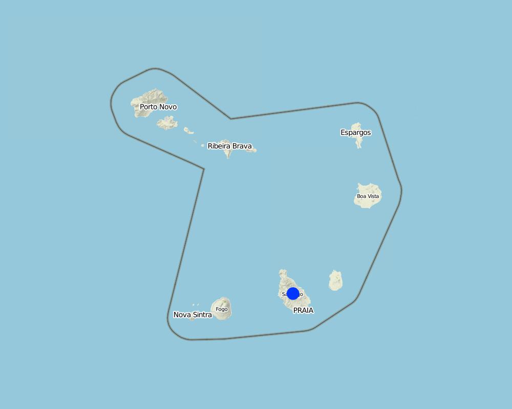
Map
×2.6 Date of implementation
If precise year is not known, indicate approximate date:
- 10-50 years ago
2.7 Introduction of the Technology
Specify how the Technology was introduced:
- during experiments/ research
Comments (type of project, etc.):
The first structures were construdas in 1978 in St. George, which was an action of FAIMO project
3. Classification of the SLM Technology
3.1 Main purpose(s) of the Technology
- improve production
- reduce, prevent, restore land degradation
- create beneficial economic impact
3.2 Current land use type(s) where the Technology is applied

Cropland
- Annual cropping
Annual cropping - Specify crops:
- cereals - maize
- legumes and pulses - beans
Number of growing seasons per year:
- 1
Specify:
Longest growing period in days: 90, Longest growing period from month to month: Aug - Oct
Comments:
Major cash crop: Horticulture
Major food crop: Maize and beans
Major land use problems (compiler’s opinion): The loss of soil by runoff, influenced by its low coverage, reducing their fertility and their thickness
Major land use problems (land users’ perception): The loss of soil by runoff, low productive soils, low organic matter
3.4 Water supply
Water supply for the land on which the Technology is applied:
- rainfed
Comments:
Water supply: Also mixed rainfed - irrigated
3.5 SLM group to which the Technology belongs
- cross-slope measure
3.6 SLM measures comprising the Technology

structural measures
- S6: Walls, barriers, palisades, fences
- S11: Others
3.7 Main types of land degradation addressed by the Technology

soil erosion by water
- Wt: loss of topsoil/ surface erosion
- Wg: gully erosion/ gullying

physical soil deterioration
- Pu: loss of bio-productive function due to other activities
Comments:
Main causes of degradation: soil management (It is cultivated maize and peanuts on land slopes very pronounced and boot), crop management (annual, perennial, tree/shrub) (At the end of each cycle of cultivation of maize, the most prevalent, the crop residues are deracinate, leading to the loss of soil cover), droughts (ocorrem secas cíclicas nesse país, sendo a mais marcante, a de 1947)
Secondary causes of degradation: overgrazing (Creation of the wild animals compact the soil, destroying the structures for the conservation of soil and water exists, and creates conflict), disturbance of water cycle (infiltration / runoff) (A fraca cobertura vegetal não favorece a infiltração da água quando chove, principalmenThe low vegetation cover, does not favor the infiltration of water when it rains, especially where there are crus), Heavy / extreme rainfall (intensity/amounts) (Sometimes heavy intensity rains that occur associated with poor vegetation cover and increase soil erosion)
3.8 Prevention, reduction, or restoration of land degradation
Specify the goal of the Technology with regard to land degradation:
- prevent land degradation
4. Technical specifications, implementation activities, inputs, and costs
4.1 Technical drawing of the Technology
Technical specifications (related to technical drawing):
Terraces in São Jorge. It shows the slope of the estruture
Location: Praia. Cabo Verde
Technical knowledge required for field staff / advisors: high (The infrastructure has a certain risk to be reduced to the maximum, based on a design, the more accurate possible. And that takes into account the greater number of variables)
Technical knowledge required for land users: moderate (Must have sufficient knowledge to understand and assimilate the technical guidance.)
Main technical functions: reduction of slope angle, reduction of slope length, sediment retention / trapping, sediment harvesting
Secondary technical functions: control of dispersed runoff: retain / trap, increase of infiltration
Wall/ barrier
Vertical interval between structures (m): 1.5-2.5
Spacing between structures (m): 10-15
Construction material (earth): A terra usada é local. A terra extraida da escavação é usada nos pontos do aterro
Construction material (stone): it´s used to make a wall, end it's taked in the local
Slope (which determines the spacing indicated above): 30-60%
If the original slope has changed as a result of the Technology, the slope today is: 50%
Lateral gradient along the structure: 1%
Specification of dams/ pans/ ponds: Capacity 1200m3
Catchment area: 600m2m2
Beneficial area: 600m2m2
Slope of dam wall inside: 200%;
Slope of dam wall outside: 170%
For water harvesting: the ratio between the area where the harvested water is applied and the total area from which water is collected is: 1:1
4.2 General information regarding the calculation of inputs and costs
other/ national currency (specify):
ECV
If relevant, indicate exchange rate from USD to local currency (e.g. 1 USD = 79.9 Brazilian Real): 1 USD =:
80.0
Indicate average wage cost of hired labour per day:
6.25
4.3 Establishment activities
| Activity | Timing (season) | |
|---|---|---|
| 1. | Leveling the terrain | April |
| 2. | Construction of the batter | June |
4.4 Costs and inputs needed for establishment
| Specify input | Unit | Quantity | Costs per Unit | Total costs per input | % of costs borne by land users | |
|---|---|---|---|---|---|---|
| Labour | Labour | ha | 1.0 | 687.5 | 687.5 | 100.0 |
| Equipment | Total | ha | 1.0 | 375.0 | 375.0 | |
| Construction material | Total | ha | 1.0 | 875.0 | 875.0 | |
| Total costs for establishment of the Technology | 1937.5 | |||||
| Total costs for establishment of the Technology in USD | 24.22 | |||||
Comments:
Duration of establishment phase: 2 month(s)
4.6 Costs and inputs needed for maintenance/ recurrent activities (per year)
Comments:
Machinery/ tools: picareta, enchada, martelo, nível,
5. Natural and human environment
5.1 Climate
Annual rainfall
- < 250 mm
- 251-500 mm
- 501-750 mm
- 751-1,000 mm
- 1,001-1,500 mm
- 1,501-2,000 mm
- 2,001-3,000 mm
- 3,001-4,000 mm
- > 4,000 mm
Agro-climatic zone
- humid
- sub-humid
- semi-arid
- arid
Thermal climate class: tropics
5.2 Topography
Slopes on average:
- flat (0-2%)
- gentle (3-5%)
- moderate (6-10%)
- rolling (11-15%)
- hilly (16-30%)
- steep (31-60%)
- very steep (>60%)
Landforms:
- plateau/plains
- ridges
- mountain slopes
- hill slopes
- footslopes
- valley floors
Altitudinal zone:
- 0-100 m a.s.l.
- 101-500 m a.s.l.
- 501-1,000 m a.s.l.
- 1,001-1,500 m a.s.l.
- 1,501-2,000 m a.s.l.
- 2,001-2,500 m a.s.l.
- 2,501-3,000 m a.s.l.
- 3,001-4,000 m a.s.l.
- > 4,000 m a.s.l.
5.6 Characteristics of land users applying the Technology
Market orientation of production system:
- subsistence (self-supply)
- mixed (subsistence/ commercial)
Off-farm income:
- > 50% of all income
Relative level of wealth:
- poor
- average
Individuals or groups:
- individual/ household
Level of mechanization:
- manual work
- mechanized/ motorized
Gender:
- women
- men
Indicate other relevant characteristics of the land users:
Land users applying the Technology are mainly common / average land users
Population density: 100-200 persons/km2
Annual population growth: > 4%
Off-farm income specification: the land users who practice the technique, get more income with agricultural production, invest more in their production
Market orientation: Mixed (ranked 1, it is intended to take advantage of the technique, getting more income) and subsistence (ranked 2)
5.7 Average area of land used by land users applying the Technology
- < 0.5 ha
- 0.5-1 ha
- 1-2 ha
- 2-5 ha
- 5-15 ha
- 15-50 ha
- 50-100 ha
- 100-500 ha
- 500-1,000 ha
- 1,000-10,000 ha
- > 10,000 ha
Is this considered small-, medium- or large-scale (referring to local context)?
- small-scale
Comments:
Those who practice this technique are those with larger parcel of land
5.8 Land ownership, land use rights, and water use rights
Land ownership:
- state
- individual, titled
Land use rights:
- individual
Water use rights:
- communal (organized)
5.9 Access to services and infrastructure
health:
- poor
- moderate
- good
education:
- poor
- moderate
- good
technical assistance:
- poor
- moderate
- good
markets:
- poor
- moderate
- good
energy:
- poor
- moderate
- good
roads and transport:
- poor
- moderate
- good
financial services:
- poor
- moderate
- good
6. Impacts and concluding statements
6.1 On-site impacts the Technology has shown
Socio-economic impacts
Production
crop production
wood production
land management
Income and costs
expenses on agricultural inputs
farm income
workload
Socio-cultural impacts
food security/ self-sufficiency
cultural opportunities
recreational opportunities
conflict mitigation
situation of socially and economically disadvantaged groups
Ecological impacts
Water cycle/ runoff
harvesting/ collection of water
surface runoff
excess water drainage
Soil
nutrient cycling/ recharge
Biodiversity: vegetation, animals
pest/ disease control
Climate and disaster risk reduction
wind velocity
6.3 Exposure and sensitivity of the Technology to gradual climate change and climate-related extremes/ disasters (as perceived by land users)
Gradual climate change
Gradual climate change
| Season | increase or decrease | How does the Technology cope with it? | |
|---|---|---|---|
| annual temperature | increase | well |
Climate-related extremes (disasters)
Meteorological disasters
| How does the Technology cope with it? | |
|---|---|
| local rainstorm | not well |
| local windstorm | well |
Climatological disasters
| How does the Technology cope with it? | |
|---|---|
| drought | well |
Hydrological disasters
| How does the Technology cope with it? | |
|---|---|
| general (river) flood | well |
Other climate-related consequences
Other climate-related consequences
| How does the Technology cope with it? | |
|---|---|
| reduced growing period | well |
6.4 Cost-benefit analysis
How do the benefits compare with the establishment costs (from land users’ perspective)?
Short-term returns:
negative
Long-term returns:
positive
How do the benefits compare with the maintenance/ recurrent costs (from land users' perspective)?
Short-term returns:
positive
Long-term returns:
very positive
Comments:
There is any maintenance operation
6.5 Adoption of the Technology
If available, quantify (no. of households and/ or area covered):
144 families and 100% of the area covered
Of all those who have adopted the Technology, how many did so spontaneously, i.e. without receiving any material incentives/ payments?
- 51-90%
Comments:
40% of land user families have adopted the Technology with external material support
60 land user families have adopted the Technology with external material support
Comments on acceptance with external material support: They were covered in the course of projects, and port as a mirror for others. Were the first to adopt the technique.
60% of land user families have adopted the Technology without any external material support
84 land user families have adopted the Technology without any external material support
Comments on spontaneous adoption: The technique has proved efficient in increasing the production and adoption, for who had the economic power for its implementation, was significant
There is a moderate trend towards spontaneous adoption of the Technology
Comments on adoption trend: The high cost of technology, makes the poor farmers, unable to adopt. But with any credit or allowance, they take the technology.
6.7 Strengths/ advantages/ opportunities of the Technology
| Strengths/ advantages/ opportunities in the compiler’s or other key resource person’s view |
|---|
| Mitigation of erosion by reducing the cinetic of runoff and the slope |
| Availability of lands for agriculture |
| Improve of production |
7. References and links
7.1 Methods/ sources of information
- field visits, field surveys
- interviews with land users
7.2 References to available publications
Title, author, year, ISBN:
Field Guide_DESIRE_Cape Verde, INIDA, 2008
Available from where? Costs?
Livrary of INIDA
Title, author, year, ISBN:
Conservação do solo e água_Cabo Verde, Antonio Sabino, 1991
Available from where? Costs?
Livrary of INIDA_CFA
Title, author, year, ISBN:
Técnicas de conservação de solo e água em Cabo Verde_MPAR & CILSS, 1994
Available from where? Costs?
Livrary of INIDA_CFA
Title, author, year, ISBN:
Conservação do solo e água_Cabo Verde, Antonio Sabino, 1984
Available from where? Costs?
Livrary of INIDA
7.3 Links to relevant online information
Title/ description:
QUIBB_INE, 2007
URL:
www.ine.cv
Links and modules
Expand all Collapse allLinks
Arborisation [Cape Verde]
No description available.
- Compiler: Jacques Tavares
Modules
No modules