Level ditches in cropland [Slovakia]
- Creation:
- Update:
- Compiler: Zuzana Studvova
- Editor: –
- Reviewers: Fabian Ottiger, Alexandra Gavilano
Záchytné pásy na poľnohospodárskej pôde (Slovak language)
technologies_1666 - Slovakia
View sections
Expand all Collapse all1. General information
1.2 Contact details of resource persons and institutions involved in the assessment and documentation of the Technology
Key resource person(s)
SLM specialist:
1.3 Conditions regarding the use of data documented through WOCAT
The compiler and key resource person(s) accept the conditions regarding the use of data documented through WOCAT:
Yes
1.5 Reference to Questionnaire(s) on SLM Approaches (documented using WOCAT)
The programme of landscape revitalization and integrated river … [Slovakia]
This approach is devoted to the implementation of 'The Landscape Revitalisation Programme and integrated river basins management of the Slovak Republic' in the Sobotište village.
- Compiler: Zuzana Studvova
2. Description of the SLM Technology
2.1 Short description of the Technology
Definition of the Technology:
Conservation measures for eroded cropland. The technology contains level ditches of various lengths, which are digged along a contour.
2.2 Detailed description of the Technology
Description:
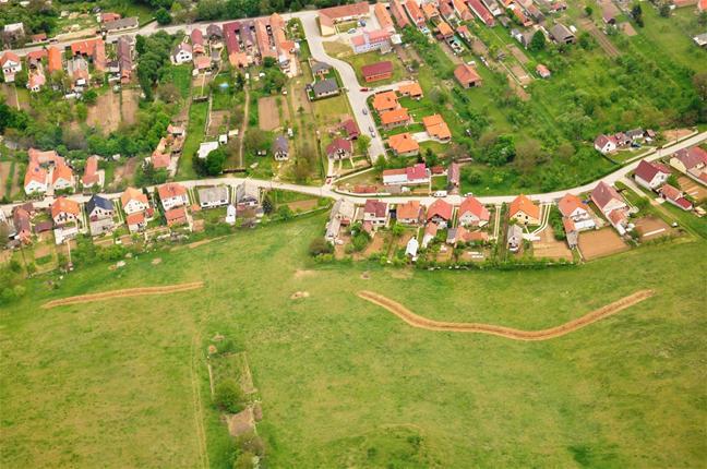
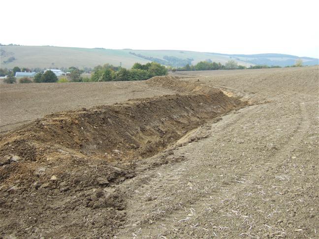
The structural measures are characterized as small technical structures to control and slow down surface runoff, created after extreme rainfall. The ditch is digged across the slope (along the contour) according to the terrain. Along the four of dithes there were also vegetative strips that should protect and retain rainfall.
Purpose of the Technology: Some damage has been observed on the farmland during storm rainfalls, long-lasting rainfalls, and periods of melting snow. The aim of the conservation measures is to eliminate hazards and damage to health and the economy, to improve the accumulation and infiltration of water into the soil, and to retard the surface runoff on the farmland.
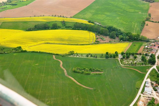
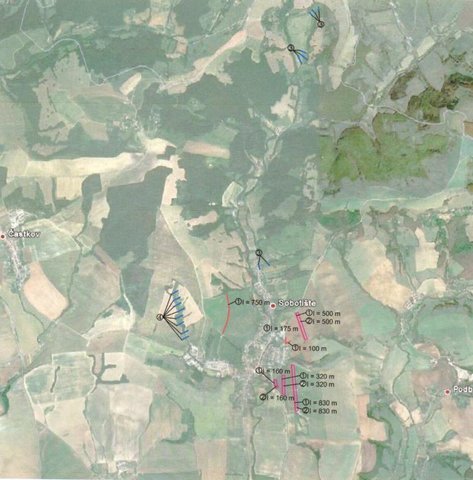
Establishment / maintenance activities and inputs: There are 7 ditches in the area (2842 m in total/ 23873 m3). In the locality of Padelky there are level ditches with lengths of 160 m + 320 m+ 830m = 1310 m; in the locality of Kubíny there are level ditches with lengths of 500 m + 100 m + 175 m = 775 m; in the locality of Šlachovec there is one ditch with the length of 750 m. The total water retention volume is 23873 m3. The ditches are in the shape of a trapezoid with a base width of 1 m, a height according to the terrain, and a slope of 1:1.5 while the digged soil is moved to the lower part of the ditch.
Natural / human environment: Sobotište is a village in the Teplica river basin; it is situated near the town of Senica in the Trnava region of western Slovakia. It is located in a valley at the foothills of the White Carpathians, which are part of the Carpathian Flysch Belt. The sedimentary flysh rocks are erodible, disintegrable, and sensitive to erosion.
2.3 Photos of the Technology
Media Gallery
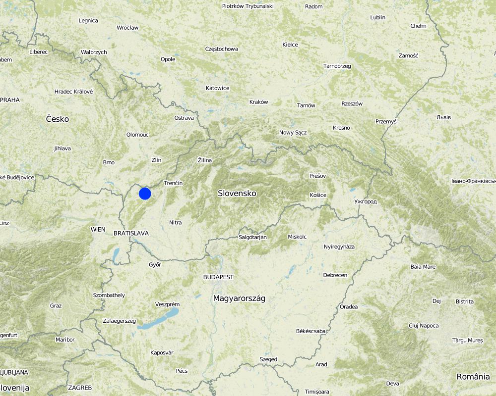
2.5 Country/ region/ locations where the Technology has been applied and which are covered by this assessment
Country:
Slovakia
Region/ State/ Province:
Slovakia
Further specification of location:
Sobotište
Comments:
Total area covered by the SLM Technology is 12.4 km2.
Total area of the cropland cover is 12.37 km2 and the eroded area was estimated as 40 % (4.948 km2). This technology is used in the locality of Padelky and Kubina. Together 7 ditches were built. The area of the village 32.3 km2.
Map
×3. Classification of the SLM Technology
3.2 Current land use type(s) where the Technology is applied

Cropland
- Annual cropping
Annual cropping - Specify crops:
- oilseed crops - sunflower, rapeseed, other
Number of growing seasons per year:
- 1
Specify:
Longest growing period in days: 180Longest growing period from month to month: April to September
Comments:
Major land use problems (compiler’s opinion): The major problem is surface runoff that is formed by extreme rainfall whereby tillage, gully,or interrill erosion is forming.
Major land use problems (land users’ perception): There are some soil threads connected with erosion probably due to agricultural practises and heavy mechanism that are visible e.g.: people had noticed a decrease of the hills peak that is tilled. Some problems with sediments occured after heavy rains, mud flowing directly to the city (cemetery, roads etc.) from the surrounding hills and fields.
Future (final) land use (after implementation of SLM Technology): Cropland: Ca: Annual cropping
3.3 Has land use changed due to the implementation of the Technology?
Has land use changed due to the implementation of the Technology?
- Yes (Please fill out the questions below with regard to the land use before implementation of the Technology)
Cropland
- Annual cropping
3.4 Water supply
Water supply for the land on which the Technology is applied:
- mixed rainfed-irrigated
3.5 SLM group to which the Technology belongs
- cross-slope measure
3.6 SLM measures comprising the Technology

vegetative measures
- V2: Grasses and perennial herbaceous plants

structural measures
- S4: Level ditches, pits
Comments:
Main measures: structural measures
Secondary measures: vegetative measures
Type of vegetative measures: aligned: -contour
3.7 Main types of land degradation addressed by the Technology

soil erosion by water
- Wt: loss of topsoil/ surface erosion
- Wo: offsite degradation effects
Comments:
Main type of degradation addressed: Wt: loss of topsoil / surface erosion
Main causes of degradation: Heavy / extreme rainfall (intensity/amounts) (Slope in connection with heavy rainfall results in surface runoff that causes erosion and mud floods in the part of the city and nearby roads), other natural causes (avalanches, volcanic eruptions, mud flows, highly susceptible natural resources, extreme topography, etc.) specify (mud flows)
Secondary causes of degradation: soil management (tillage along the slopes, deep tillage), land tenure (Land belongs to private owners and there is often a problem to get permission to use their land for other purposes, or to built conservation measures. The process of land consolidation is too long.), governance / institutional (Legislation: The financial support from the state is mainly focused on flood protection for the main rivers.)
3.8 Prevention, reduction, or restoration of land degradation
Specify the goal of the Technology with regard to land degradation:
- prevent land degradation
- reduce land degradation
Comments:
Main goals: mitigation / reduction of land degradation
Secondary goals: prevention of land degradation
4. Technical specifications, implementation activities, inputs, and costs
4.1 Technical drawing of the Technology
Technical specifications (related to technical drawing):
There are 7 ditches in the area (2842 m in total/ 23873 m3). In the locality of Padelky there are level ditches with lengths of 160 m + 320 m+ 830m = 1310 m; in the locality of Kubíny there are level ditches with lengths of 500 m + 100 m + 175 m = 775 m; in the locality of Šlachovec there is one ditch with the length of 750 m. The total water retention volume is 23873 m3. The ditches are in the shape of a trapezoid with a base width of 1 m, a height according to the terrain, and a slope of 1:1.5 while the digged soil is moved to the lower part of the ditch.
Location: Sobotište. Myjava, Slovakia
Technical knowledge required for field staff / advisors: moderate
Technical knowledge required for land users: low
Main technical functions: control of concentrated runoff: retain / trap
Secondary technical functions: reduction of slope length, sediment retention / trapping, sediment harvesting
Aligned: -contour
Vegetative material: O : other
Number of plants per (ha): -
Vertical interval between rows / strips / blocks (m): -
Spacing between rows / strips / blocks (m): -
Vertical interval within rows / strips / blocks (m): -
Width within rows / strips / blocks (m): 40
Other species: Red clover, seeded along the ditch
Retention/infiltration ditch/pit, sediment/sand trap
Depth of ditches/pits/dams (m): 1
Width of ditches/pits/dams (m): 1
Length of ditches/pits/dams (m): various, 2842 m in total
Construction material (earth): The excavated earth is placed on the lower part and mechanically compacted to hold retained water.
Specification of dams/ pans/ ponds: Capacity 23873m3
Catchment area: 12 ham2
4.2 General information regarding the calculation of inputs and costs
other/ national currency (specify):
Eur
If relevant, indicate exchange rate from USD to local currency (e.g. 1 USD = 79.9 Brazilian Real): 1 USD =:
0.88
4.3 Establishment activities
| Activity | Timing (season) | |
|---|---|---|
| 1. | Digging of the ditch for 600 mm width | |
| 2. | Adjustment of the ditch´s embankment | |
| 3. | Digging of the ditch for 600-2000 mm width | |
| 4. | Digging of the ditch for over 2000 mm width | |
| 5. | expert guarantor and planner | |
| 6. | Transfer | |
| 7. | Vegetative strips next to the ditch in 40 m width. Red clover. | spring |
4.4 Costs and inputs needed for establishment
| Specify input | Unit | Quantity | Costs per Unit | Total costs per input | % of costs borne by land users | |
|---|---|---|---|---|---|---|
| Labour | Digging of the ditch for 600 mm width | m3 | 9.9 | 18.14 | 179.59 | |
| Labour | Adjustment of the ditch´s embankment | m2 | 3861.0 | 0.82 | 3166.02 | |
| Labour | Digging of the ditch for 600-2000 mm width | m2 | 5253.0 | 10.24 | 53790.72 | |
| Labour | or Digging of the ditch for over 2000 mm width | m2 | 5253.0 | 1.26 | 6618.78 | |
| Plant material | Seeds for vegetative strips next to the ditch in 40 m width. Red clover. | kg | 704.0 | 8.15 | 5737.6 | |
| Other | expert guarantor and planner | person | 1.0 | 3062.61 | 3062.61 | |
| Other | Transfer | t | 58.655 | 46.11 | 2704.58 | |
| Total costs for establishment of the Technology | 75259.9 | |||||
| Total costs for establishment of the Technology in USD | 85522.61 | |||||
4.6 Costs and inputs needed for maintenance/ recurrent activities (per year)
Comments:
Together 7 ditches were built in the study area (1240 ha of cropland). The prices and costs were available as a summary for whole project, therefore the prices correspond for all 7 ditches together. Each of the ditches were slitly different (e.g., the length). The prices are valid for the year 2011. The prices are mostly given for m3 as a unit. (The prices were calculated with the 20% VAT)
4.7 Most important factors affecting the costs
Describe the most determinate factors affecting the costs:
The costs differ from project to project, it depends on the design, building company atc.
5. Natural and human environment
5.1 Climate
Annual rainfall
- < 250 mm
- 251-500 mm
- 501-750 mm
- 751-1,000 mm
- 1,001-1,500 mm
- 1,501-2,000 mm
- 2,001-3,000 mm
- 3,001-4,000 mm
- > 4,000 mm
Agro-climatic zone
- sub-humid
Thermal climate class: temperate
5.2 Topography
Slopes on average:
- flat (0-2%)
- gentle (3-5%)
- moderate (6-10%)
- rolling (11-15%)
- hilly (16-30%)
- steep (31-60%)
- very steep (>60%)
Landforms:
- plateau/plains
- ridges
- mountain slopes
- hill slopes
- footslopes
- valley floors
Altitudinal zone:
- 0-100 m a.s.l.
- 101-500 m a.s.l.
- 501-1,000 m a.s.l.
- 1,001-1,500 m a.s.l.
- 1,501-2,000 m a.s.l.
- 2,001-2,500 m a.s.l.
- 2,501-3,000 m a.s.l.
- 3,001-4,000 m a.s.l.
- > 4,000 m a.s.l.
Comments and further specifications on topography:
Slopes on average: Flat (59%), gentle, (23%) and moderate (9%)
5.3 Soils
Soil depth on average:
- very shallow (0-20 cm)
- shallow (21-50 cm)
- moderately deep (51-80 cm)
- deep (81-120 cm)
- very deep (> 120 cm)
Soil texture (topsoil):
- coarse/ light (sandy)
If available, attach full soil description or specify the available information, e.g. soil type, soil PH/ acidity, Cation Exchange Capacity, nitrogen, salinity etc.
Soil depth on average: Moderately deep (75%), shallow (17%) and very shallow (5%)
Soil texture is coarse/light (34%), fine/heavy (12%) and medium (5%)
Soil fertiliy is medium
Top soil organic matter is unknown
Soil drainage/infiltration is good
Soil water storage capacity is unknown
5.4 Water availability and quality
Availability of surface water:
excess
Water quality (untreated):
good drinking water
Comments and further specifications on water quality and quantity:
Ground water table is unknown
5.5 Biodiversity
Species diversity:
- medium
5.6 Characteristics of land users applying the Technology
Market orientation of production system:
- mixed (subsistence/ commercial)
- commercial/ market
Relative level of wealth:
- average
Individuals or groups:
- groups/ community
Level of mechanization:
- mechanized/ motorized
Gender:
- women
- men
Indicate other relevant characteristics of the land users:
Land users applying the Technology are mainly common / average land users
Difference in the involvement of women and men: no.
Population density: 10-50 persons/km2
Annual population growth: > 4%; 16%
Off-farm income specification: unknown
5.7 Average area of land used by land users applying the Technology
- < 0.5 ha
- 0.5-1 ha
- 1-2 ha
- 2-5 ha
- 5-15 ha
- 15-50 ha
- 50-100 ha
- 100-500 ha
- 500-1,000 ha
- 1,000-10,000 ha
- > 10,000 ha
Is this considered small-, medium- or large-scale (referring to local context)?
- medium-scale
Comments:
There are 485 permanently occupied dwellings (2001)
5.8 Land ownership, land use rights, and water use rights
Land ownership:
- communal/ village
Land use rights:
- communal (organized)
- individual
Water use rights:
- communal (organized)
- individual
5.9 Access to services and infrastructure
health:
- poor
- moderate
- good
education:
- poor
- moderate
- good
technical assistance:
- poor
- moderate
- good
employment (e.g. off-farm):
- poor
- moderate
- good
markets:
- poor
- moderate
- good
energy:
- poor
- moderate
- good
roads and transport:
- poor
- moderate
- good
drinking water and sanitation:
- poor
- moderate
- good
financial services:
- poor
- moderate
- good
6. Impacts and concluding statements
6.1 On-site impacts the Technology has shown
Socio-economic impacts
Production
crop production
Socio-cultural impacts
Improved livelihoods and human well-being
Comments/ specify:
The technology decreased risk of the mud flows that are capable of destroying homes, washing out roads, knocking down trees, and obstructing roadways.
Ecological impacts
Water cycle/ runoff
surface runoff
Soil
soil cover
soil loss
Other ecological impacts
Risk of mud flood
Hazard towards averse events
6.2 Off-site impacts the Technology has shown
damage on public/ private infrastructure
Comments/ specify:
Reduced risk of flooding and damage of the gardens and household.
Reduced the hazards and damage of the surrounding area by heavy rainfall events.
6.3 Exposure and sensitivity of the Technology to gradual climate change and climate-related extremes/ disasters (as perceived by land users)
Gradual climate change
Gradual climate change
| Season | increase or decrease | How does the Technology cope with it? | |
|---|---|---|---|
| annual temperature | increase | well |
Climate-related extremes (disasters)
Meteorological disasters
| How does the Technology cope with it? | |
|---|---|
| local rainstorm | not well |
| local windstorm | well |
Climatological disasters
| How does the Technology cope with it? | |
|---|---|
| drought | well |
Hydrological disasters
| How does the Technology cope with it? | |
|---|---|
| general (river) flood | not well |
Other climate-related consequences
Other climate-related consequences
| How does the Technology cope with it? | |
|---|---|
| reduced growing period | well |
6.4 Cost-benefit analysis
How do the benefits compare with the establishment costs (from land users’ perspective)?
Short-term returns:
very positive
Long-term returns:
positive
How do the benefits compare with the maintenance/ recurrent costs (from land users' perspective)?
Short-term returns:
very positive
Long-term returns:
positive
Comments:
There were no maintanance required so far.
6.5 Adoption of the Technology
Of all those who have adopted the Technology, how many did so spontaneously, i.e. without receiving any material incentives/ payments?
- 0-10%
Comments:
100% of land user families have adopted the Technology with external material support
Comments on acceptance with external material support: The implementation of the technology was founded by the state (subsidy).
Comments on adoption trend: UNknown
6.7 Strengths/ advantages/ opportunities of the Technology
| Strengths/ advantages/ opportunities in the land user’s view |
|---|
| The technology shows to be effective, however the rainfall events that have occured so far were not that extreme as before the implementation. |
| Strengths/ advantages/ opportunities in the compiler’s or other key resource person’s view |
|---|
| The technology is easy to realize. There is no extra knowledge required. The mechanism used to implement the technology is easy to provide. |
6.8 Weaknesses/ disadvantages/ risks of the Technology and ways of overcoming them
| Weaknesses/ disadvantages/ risks in the land user’s view | How can they be overcome? |
|---|---|
| The land users are satisfied with effectivness of the technology. |
| Weaknesses/ disadvantages/ risks in the compiler’s or other key resource person’s view | How can they be overcome? |
|---|---|
| I don´t see any disadvantage or weekness of the technology. |
7. References and links
7.1 Methods/ sources of information
7.2 References to available publications
Title, author, year, ISBN:
Project documentation, Hydrotechnológia Bratislava, s.r.o., April 2011
7.3 Links to relevant online information
URL:
http://www.obecsobotiste.sk/Vodozadrzne-opatrenia.aspx
URL:
https://www.nku.gov.sk/documents/10157/19a2305b-d9c2-43a7-8262-743650db289b
Links and modules
Expand all Collapse allLinks
The programme of landscape revitalization and integrated river … [Slovakia]
This approach is devoted to the implementation of 'The Landscape Revitalisation Programme and integrated river basins management of the Slovak Republic' in the Sobotište village.
- Compiler: Zuzana Studvova
Modules
No modules