Water retention basin, a flood-control reservoir [Slovakia]
- Creation:
- Update:
- Compiler: Zuzana Studvova
- Editor: –
- Reviewers: Fabian Ottiger, Alexandra Gavilano
Polder (Slovak language)
technologies_1675 - Slovakia
View sections
Expand all Collapse all1. General information
1.2 Contact details of resource persons and institutions involved in the assessment and documentation of the Technology
Name of project which facilitated the documentation/ evaluation of the Technology (if relevant)
Preventing and Remediating degradation of soils in Europe through Land Care (EU-RECARE )Name of the institution(s) which facilitated the documentation/ evaluation of the Technology (if relevant)
Slovak University of Technology (Slovak University of Technology) - Slovakia1.3 Conditions regarding the use of data documented through WOCAT
The compiler and key resource person(s) accept the conditions regarding the use of data documented through WOCAT:
Yes
2. Description of the SLM Technology
2.1 Short description of the Technology
Definition of the Technology:
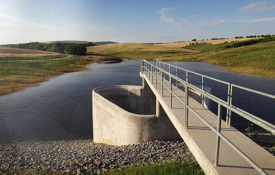
Flood-Control Reservoir - a complex hydraulic facility
2.2 Detailed description of the Technology
Description:
The construction is designed to prevent the flooding of the territory located behind the structure, to eliminate the threat of floods caused by storm rainfall and inappropriate farming, and to reduce flow fluctuation.
Purpose of the Technology: The Svacenický creek polder was built to transform Q100 flood waves.
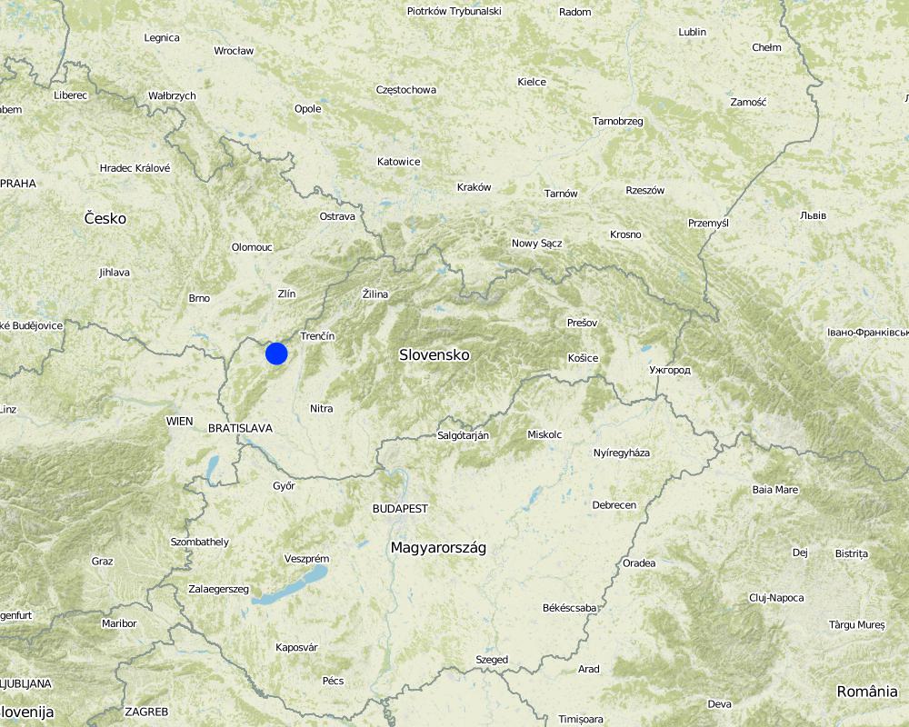
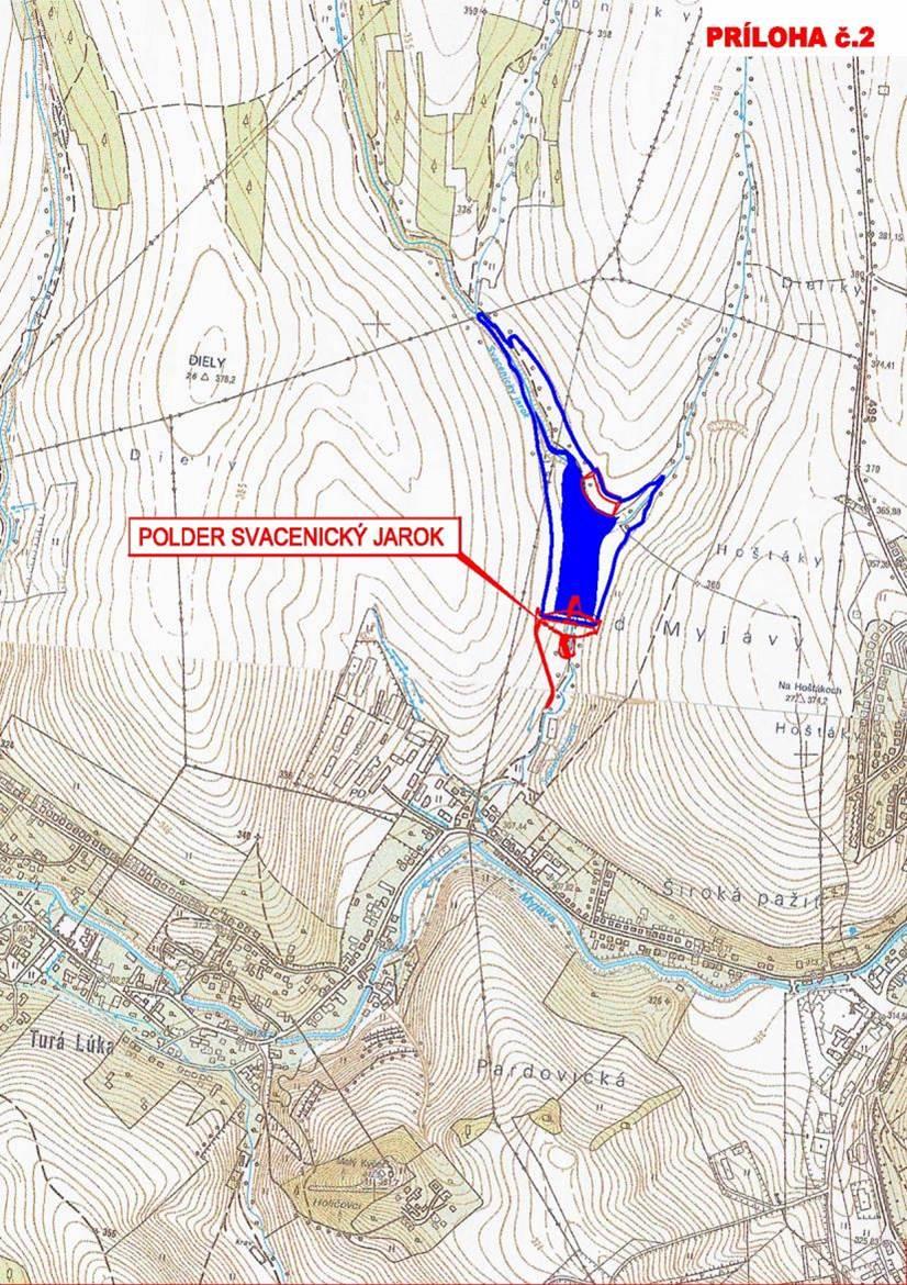
Natural / human environment: The Svacenický creek polder is part of the flood protection of the area, which is located in the west of Slovakia in the cadastral area of the town of Myjava, in the locality of Tura Luka. The town of Myjava has been plagued by frequent floods in recent years, which have resulted in significant material damage, thereby severely hampering the quality of the local residents´ lives.
2.3 Photos of the Technology
Media Gallery
2.5 Country/ region/ locations where the Technology has been applied and which are covered by this assessment
Country:
Slovakia
Region/ State/ Province:
Slovakia / Trenčiansky region
Further specification of location:
Myjava / Turá Lúka
Specify the spread of the Technology:
- evenly spread over an area
If precise area is not known, indicate approximate area covered:
- < 0.1 km2 (10 ha)
Comments:
The reservoir is situated at the Svacenický Creek.
Map
×2.6 Date of implementation
If precise year is not known, indicate approximate date:
- 10-50 years ago
2.7 Introduction of the Technology
Specify how the Technology was introduced:
- through projects/ external interventions
3. Classification of the SLM Technology
3.2 Current land use type(s) where the Technology is applied

Cropland
- Annual cropping
Number of growing seasons per year:
- 1
Specify:
Longest growing period in days: 180Longest growing period from month to month: April to September

Waterways, waterbodies, wetlands
- Drainage lines, waterways
- Ponds, dams
Comments:
Major land use problems (compiler’s opinion): Generation of gulllies.
Major land use problems (land users’ perception): Generation of gulllies and landslides.
Future (final) land use (after implementation of SLM Technology): Other: Ow: Waterways, drainage lines, ponds, dams
3.3 Has land use changed due to the implementation of the Technology?
Has land use changed due to the implementation of the Technology?
- Yes (Please fill out the questions below with regard to the land use before implementation of the Technology)
Cropland
- Annual cropping
3.4 Water supply
Water supply for the land on which the Technology is applied:
- mixed rainfed-irrigated
3.5 SLM group to which the Technology belongs
- surface water management (spring, river, lakes, sea)
3.6 SLM measures comprising the Technology

vegetative measures
- V1: Tree and shrub cover
- V2: Grasses and perennial herbaceous plants

structural measures
- S5: Dams, pans, ponds
Comments:
Main measures: structural measures
Secondary measures: vegetative measures
Type of vegetative measures: scattered / dispersed
3.7 Main types of land degradation addressed by the Technology

soil erosion by water
- Wg: gully erosion/ gullying
- Wm: mass movements/ landslides
Comments:
Main type of degradation addressed: Wm: mass movements / landslides
Secondary types of degradation addressed: Wg: gully erosion / gullying
Main causes of degradation: Heavy / extreme rainfall (intensity/amounts), floods
Secondary causes of degradation: soil management, crop management (annual, perennial, tree/shrub)
3.8 Prevention, reduction, or restoration of land degradation
Specify the goal of the Technology with regard to land degradation:
- prevent land degradation
Comments:
Main goals: prevention of land degradation
4. Technical specifications, implementation activities, inputs, and costs
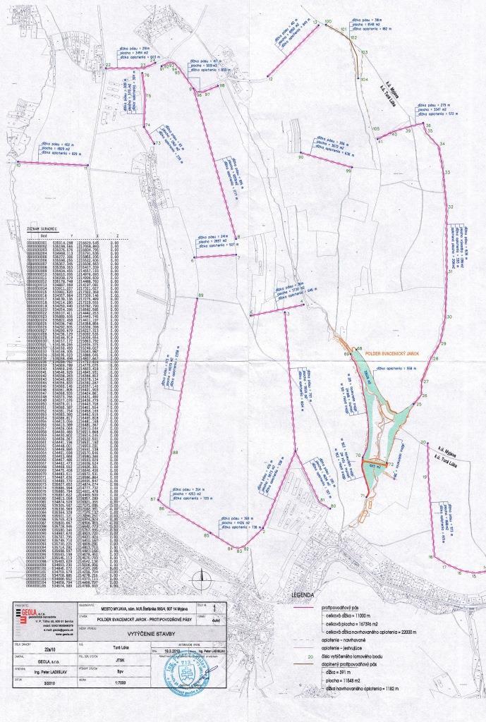
4.1 Technical drawing of the Technology
Technical specifications (related to technical drawing):
This technical drawing shows where the reservoir is localized. Blue colour presents the reservoir, red represents a complex hydraulic facility that is situated by the polder.
Location: The town of Myjava - the locality of Turá Lúka. Slovakia
Technical knowledge required for field staff / advisors: low
Technical knowledge required for land users: low
Technical knowledge required for Design and construction engineers: high (The preparatory and design documentation is needed.)
Main technical functions: control of concentrated runoff: retain / trap
Secondary technical functions: stabilisation of soil (eg by tree roots against land slides)
Aligned: -linear
Vegetative material: G : grass
Scattered / dispersed
Vegetative material: T : trees / shrubs, F : fruit trees / shrubs
Trees/ shrubs species: together 50 000 plants
Specification of dams/ pans/ ponds: Capacity 215,800m3
Catchment area: 6 km2m2
Beneficial area: 3 ham2
Slope of dam wall inside: -%;
Slope of dam wall outside: -%
Dimensions of spillways: -m
Other specifications: -
Vegetation is used for stabilisation of structures.
4.2 General information regarding the calculation of inputs and costs
other/ national currency (specify):
euro
If relevant, indicate exchange rate from USD to local currency (e.g. 1 USD = 79.9 Brazilian Real): 1 USD =:
0.91
4.6 Costs and inputs needed for maintenance/ recurrent activities (per year)
Comments:
The list of main activities:1/Land purchase (144849.574 USD),2/ Preparatory and design documentation (49305.338 USD), 3/Construction works (2345530.958 USD), 4/Constuction supervision (40135.48 USD), 5/Supporting activities (dissemination 494.55 USD, project management 40098.993 USD).
4.7 Most important factors affecting the costs
Describe the most determinate factors affecting the costs:
The most determinate factors that affect the costs are realization works and material used, and repurchase of land.
5. Natural and human environment
5.1 Climate
Annual rainfall
- < 250 mm
- 251-500 mm
- 501-750 mm
- 751-1,000 mm
- 1,001-1,500 mm
- 1,501-2,000 mm
- 2,001-3,000 mm
- 3,001-4,000 mm
- > 4,000 mm
Agro-climatic zone
- sub-humid
Thermal climate class: temperate
5.2 Topography
Slopes on average:
- flat (0-2%)
- gentle (3-5%)
- moderate (6-10%)
- rolling (11-15%)
- hilly (16-30%)
- steep (31-60%)
- very steep (>60%)
Landforms:
- plateau/plains
- ridges
- mountain slopes
- hill slopes
- footslopes
- valley floors
Altitudinal zone:
- 0-100 m a.s.l.
- 101-500 m a.s.l.
- 501-1,000 m a.s.l.
- 1,001-1,500 m a.s.l.
- 1,501-2,000 m a.s.l.
- 2,001-2,500 m a.s.l.
- 2,501-3,000 m a.s.l.
- 3,001-4,000 m a.s.l.
- > 4,000 m a.s.l.
Comments and further specifications on topography:
Altitudinal zone: 101-500 m a.s.l. (370-400 m a.s.l.)
5.3 Soils
Soil depth on average:
- very shallow (0-20 cm)
- shallow (21-50 cm)
- moderately deep (51-80 cm)
- deep (81-120 cm)
- very deep (> 120 cm)
Soil texture (topsoil):
- medium (loamy, silty)
- fine/ heavy (clay)
5.4 Water availability and quality
Water quality (untreated):
good drinking water
5.6 Characteristics of land users applying the Technology
Relative level of wealth:
- average
Level of mechanization:
- mechanized/ motorized
Indicate other relevant characteristics of the land users:
Population density: 50-100 persons/km2
Market orientation of production system: subsistence (self-supply), mixed (subsistence/ commercial, commercial/ market
5.7 Average area of land used by land users applying the Technology
- < 0.5 ha
- 0.5-1 ha
- 1-2 ha
- 2-5 ha
- 5-15 ha
- 15-50 ha
- 50-100 ha
- 100-500 ha
- 500-1,000 ha
- 1,000-10,000 ha
- > 10,000 ha
Comments:
Average area of land owned or leased by land users applying the Technology: Also 1-2 ha
5.8 Land ownership, land use rights, and water use rights
Land use rights:
- communal (organized)
Comments:
Land ownership: state, communal / village, individual, not titled
5.9 Access to services and infrastructure
health:
- poor
- moderate
- good
education:
- poor
- moderate
- good
technical assistance:
- poor
- moderate
- good
employment (e.g. off-farm):
- poor
- moderate
- good
markets:
- poor
- moderate
- good
energy:
- poor
- moderate
- good
roads and transport:
- poor
- moderate
- good
drinking water and sanitation:
- poor
- moderate
- good
financial services:
- poor
- moderate
- good
6. Impacts and concluding statements
6.1 On-site impacts the Technology has shown
Socio-cultural impacts
Improved livelihoods and human well-being
Comments/ specify:
The technology had a positive impact on the natural monument river Myjava. These are: - Reduction of catastrophic floods in the Tura Luka profile approx. 10% - Minimum flows also increased water runoff approx. 10%
Ecological impacts
Biodiversity: vegetation, animals
habitat diversity
Comments/ specify:
Destruction of the use of certain habitats
Other ecological impacts
Risk towards adverse events
Comments/ specify:
Reduced risk of flooding and thereby material damage.
Flood discharge in the Myjava river
Comments/ specify:
10 % decrease of flood discharge
Flood discharge in the Svacenický creelk
New possibilities
Comments/ specify:
New water reservoir
New habitats
Removal of riparian vegetation
Comments/ specify:
Temporary
6.2 Off-site impacts the Technology has shown
reliable and stable stream flows in dry season
downstream flooding
damage on public/ private infrastructure
6.3 Exposure and sensitivity of the Technology to gradual climate change and climate-related extremes/ disasters (as perceived by land users)
Gradual climate change
Gradual climate change
| Season | increase or decrease | How does the Technology cope with it? | |
|---|---|---|---|
| annual temperature | increase | well |
Climate-related extremes (disasters)
Meteorological disasters
| How does the Technology cope with it? | |
|---|---|
| local rainstorm | well |
| local windstorm | not known |
Climatological disasters
| How does the Technology cope with it? | |
|---|---|
| drought | well |
Hydrological disasters
| How does the Technology cope with it? | |
|---|---|
| general (river) flood | well |
Other climate-related consequences
Other climate-related consequences
| How does the Technology cope with it? | |
|---|---|
| reduced growing period | well |
6.4 Cost-benefit analysis
Comments:
No information about maintenance costs was given.
6.7 Strengths/ advantages/ opportunities of the Technology
| Strengths/ advantages/ opportunities in the compiler’s or other key resource person’s view |
|---|
| reduction of catastrophic floods in the Tura Luka profile by approx. 10% |
| change in the landscape´s structure, provides a new landscape element – a water area and newly constructed accompanying greenery |
| Minimum flows increased by approx. 10% |
| The construction of the polder will bring about new and improved conditions for other organisms, as it will create new habitats. |
6.8 Weaknesses/ disadvantages/ risks of the Technology and ways of overcoming them
| Weaknesses/ disadvantages/ risks in the compiler’s or other key resource person’s view | How can they be overcome? |
|---|---|
| During the construction and operations arable land will not be usable. | |
| Construction of the polder will create a new water area, but in terms of the technical design, the construction will not affect the water table in the greater area. | |
| The effects on the air quality during the construction are normally associated with an increased risk of dust (construction, transport), but this will have a short-term impact. | |
| There will be a temporary cessation of the use of certain habitats as a result of the taking of the land. It is expected that during the construction, trees will be cut down or damaged or that those habitats that are located in the bank vegetation of the Svacenicky creek and its immediate vicinity will disappear. This activity will affect approx. 0.35% of the entire length of the original riverbed. The taking of the land may result in injury or death to small mammals. |
7. References and links
7.2 References to available publications
Title, author, year, ISBN:
http://www.enviroportal.sk/sk_SK/eia/detail/polder-svacenicky-jarok-myjava http://vodotika.sk/projects/polder-svacenicky-jarok/ http://www.vahostav-sk.sk/galeria-vahostav/vodohospodarske-stavby/protipovodnove-ochrany/polder-svacenicky-jarok-myjava
Links and modules
Expand all Collapse allLinks
No links
Modules
No modules