SPRING GROUND WATER RESERVOIR FOR WATER SUPPLY AND FISH PRODUCTION [Uganda]
- Creation:
- Update:
- Compiler: betty adoch
- Editors: JOY TUKAHIRWA, Kamugisha Rick Nelson
- Reviewer: Udo Höggel
gwoko pii i tengom
technologies_2834 - Uganda
View sections
Expand all Collapse all1. General information
1.2 Contact details of resource persons and institutions involved in the assessment and documentation of the Technology
Key resource person(s)
land user:
Okecocon Alex
0712262059 / 0788945199
Goba Farmers group
Amuru district. Palwong Subcounty, Rubangadeg parish, Goba village.
Uganda
Name of project which facilitated the documentation/ evaluation of the Technology (if relevant)
Scaling-up SLM practices by smallholder farmers (IFAD)Name of the institution(s) which facilitated the documentation/ evaluation of the Technology (if relevant)
CDE Centre for Development and Environment (CDE Centre for Development and Environment) - Switzerland1.3 Conditions regarding the use of data documented through WOCAT
When were the data compiled (in the field)?
26/05/2017
The compiler and key resource person(s) accept the conditions regarding the use of data documented through WOCAT:
Yes
1.4 Declaration on sustainability of the described Technology
Is the Technology described here problematic with regard to land degradation, so that it cannot be declared a sustainable land management technology?
No
2. Description of the SLM Technology
2.1 Short description of the Technology
Definition of the Technology:
Spring ground water reservoir to supply water for the fish pond during dry season to be harvested throughout the year.
2.2 Detailed description of the Technology
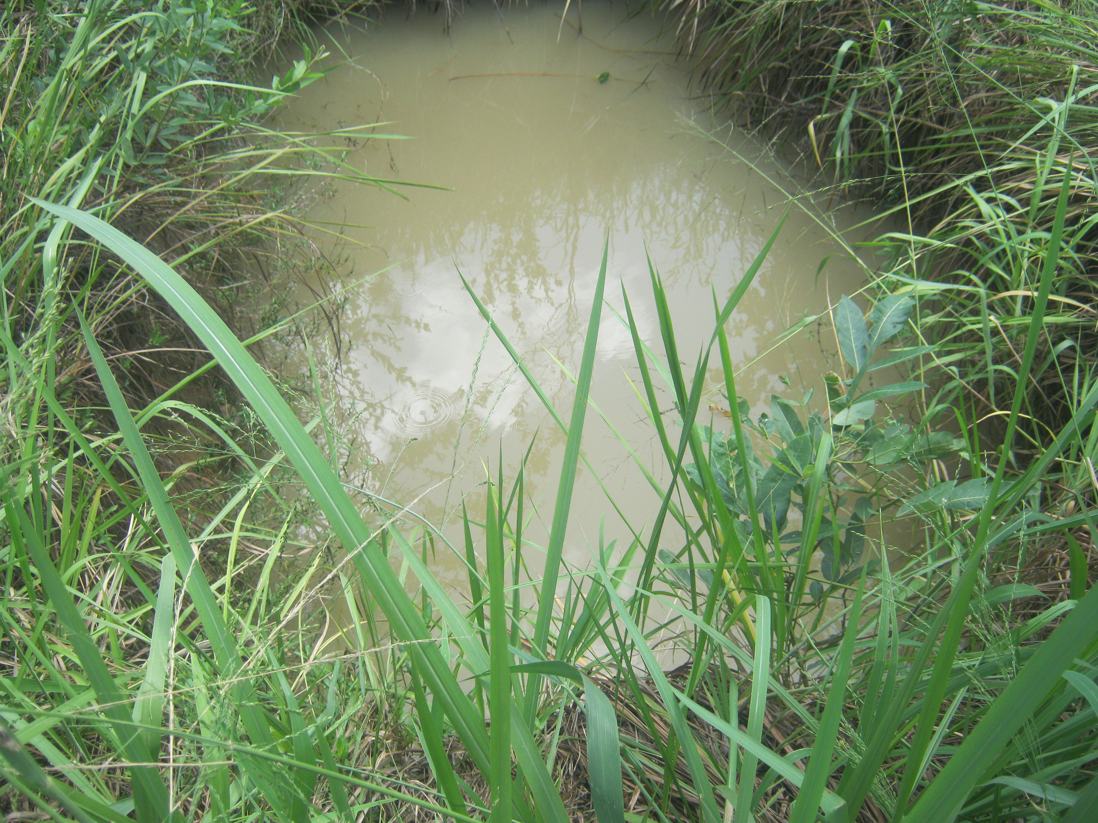
Description:
The spring ground water harvesting technology is one of the practices promoted by farmers in Northern Uganda with the aim of protecting and storing water which is used to refill the fish pond during dry season and also for fish production and household income both in the short, medium and long term.
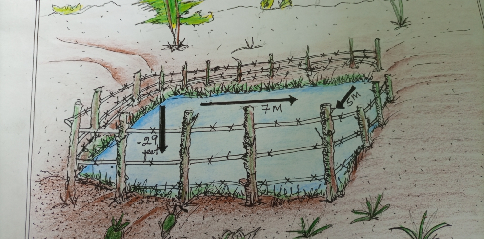
Using hoes, spades, panga and labour, the water reservoir is dug at a length and width of 5*7 meters and a depth of 29 feet. Water fills the reservoir from ground water minor channels that drains at a specific point. Hence the reservoir fills up relatively fast. The reservoir site is well protected being fenced by barbed wire to avoid accidents from humans and animals who might fall into the reservoir.
Ridges are dug to prevent running external water from entering into the reservoir thus contaminating it. Grass grows around the cliff and around the reservoir to protect and compact the soil and prevent it from collapsing into the water, during dry season, water from reservoir is pumped into the fish pond. The water reservoir keeps water through out the year and fingerlings of 2 types or more of fish species kept in the fish pond. Sunlight can generally penetrate the pond waters to a depth of about 30-80 cm depending on the water level.
The fish species mostly kept include Tilapia, Nile Perch and wild fish. Once the technology is established the spring water reservior system requires only maintenance costs for removing weeds, feeding, restocking and slashing around spring water reservior. What is not liked about this technology is that it relies on a natural spring for its water supply. In case of drought survival of the fish is not guaranteed.
2.3 Photos of the Technology
Media Gallery
2.5 Country/ region/ locations where the Technology has been applied and which are covered by this assessment
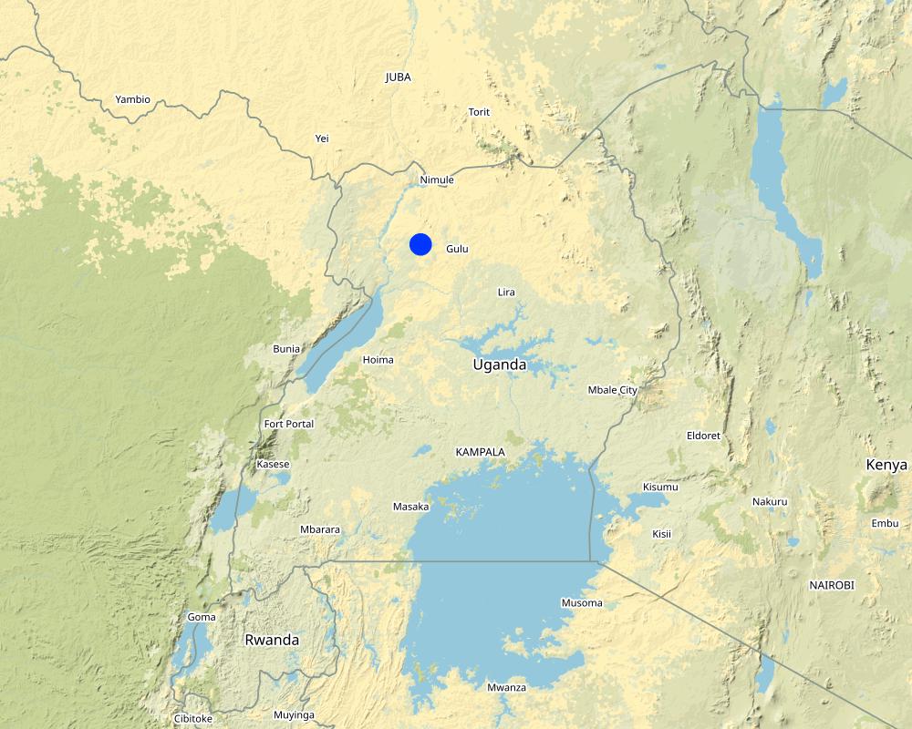
Country:
Uganda
Region/ State/ Province:
Northern Uganda.
Further specification of location:
Amuru Town Council
Map
×2.6 Date of implementation
Indicate year of implementation:
2012
2.7 Introduction of the Technology
Specify how the Technology was introduced:
- through land users' innovation
Comments (type of project, etc.):
The land-user wanted to have a constant supply of water for the fish pond.
3. Classification of the SLM Technology
3.1 Main purpose(s) of the Technology
- improve production
- adapt to climate change/ extremes and its impacts
- create beneficial economic impact
3.2 Current land use type(s) where the Technology is applied

Waterways, waterbodies, wetlands
- Ponds, dams
Comments:
By water-harvesting, water can be stored in the soil.
If land use has changed due to the implementation of the Technology, indicate land use before implementation of the Technology:
The area was used for crop growing.
3.3 Further information about land use
Water supply for the land on which the Technology is applied:
- rainfed
Specify:
Throughout the year.
3.4 SLM group to which the Technology belongs
- water harvesting
- ground water management
3.5 Spread of the Technology
Specify the spread of the Technology:
- applied at specific points/ concentrated on a small area
3.6 SLM measures comprising the Technology

other measures
Comments:
The water reservoir store excess water that would, otherwise cause flooding at the valley bottom.
3.7 Main types of land degradation addressed by the Technology

soil erosion by water
- Wt: loss of topsoil/ surface erosion

water degradation
- Hg: change in groundwater/aquifer level
3.8 Prevention, reduction, or restoration of land degradation
Specify the goal of the Technology with regard to land degradation:
- not applicable
Comments:
The technology promotes storing of excess water in water reservoirs. Without this, flooding would occur in times of heavy rains thus creating hazards for life.
4. Technical specifications, implementation activities, inputs, and costs
4.1 Technical drawing of the Technology
4.2 Technical specifications/ explanations of technical drawing
The water reservoir is dug at a length and width of 5*7 meters and a depth of 29 feet. The reservoir site is well protected being fenced by barbed wire to avoid accidents for humans and animals who might fall into the pool.
4.3 General information regarding the calculation of inputs and costs
Specify how costs and inputs were calculated:
- per Technology area
Indicate size and area unit:
0.5 acre
other/ national currency (specify):
UGX
Indicate exchange rate from USD to local currency (if relevant): 1 USD =:
3600.0
Indicate average wage cost of hired labour per day:
3000shs
4.4 Establishment activities
| Activity | Type of measure | Timing | |
|---|---|---|---|
| 1. | site clearing | Structural | dry and wet |
| 2. | digging pit | Structural | dry and wet |
Comments:
The technology is easy to establish.
4.5 Costs and inputs needed for establishment
| Specify input | Unit | Quantity | Costs per Unit | Total costs per input | % of costs borne by land users | |
|---|---|---|---|---|---|---|
| Labour | Labour | Manday | 30.0 | 5000.0 | 150000.0 | 100.0 |
| Equipment | Hoes | pieces | 3.0 | 10000.0 | 30000.0 | 100.0 |
| Equipment | Spades | pieces | 3.0 | 10000.0 | 30000.0 | 100.0 |
| Equipment | Panga | pieces | 3.0 | 10000.0 | 30000.0 | 100.0 |
| Construction material | Barbed wire | roll | 1.0 | 100000.0 | 100000.0 | 100.0 |
| Construction material | Wooden poles | pieces | 10.0 | 5000.0 | 50000.0 | 100.0 |
| Other | Fingerlings | Animals | 50.0 | 1000.0 | 50000.0 | 100.0 |
| Total costs for establishment of the Technology | 440000.0 | |||||
Comments:
Labour, barbed wire and fingerlings take the most costs for this technology.
4.6 Maintenance/ recurrent activities
| Activity | Type of measure | Timing/ frequency | |
|---|---|---|---|
| 1. | Fenching to avoid accidents | Management | dry and wet |
| 2. | Slashing the area | Management | dry and wet |
4.7 Costs and inputs needed for maintenance/ recurrent activities (per year)
| Specify input | Unit | Quantity | Costs per Unit | Total costs per input | % of costs borne by land users | |
|---|---|---|---|---|---|---|
| Labour | Labour for cleaning | Manday | 30.0 | 5000.0 | 150000.0 | 100.0 |
| Total costs for maintenance of the Technology | 150000.0 | |||||
Comments:
The cost of maintenance is manageable for the land user.
4.8 Most important factors affecting the costs
Describe the most determinate factors affecting the costs:
Labour costs are the main maintenance costs.
5. Natural and human environment
5.1 Climate
Annual rainfall
- < 250 mm
- 251-500 mm
- 501-750 mm
- 751-1,000 mm
- 1,001-1,500 mm
- 1,501-2,000 mm
- 2,001-3,000 mm
- 3,001-4,000 mm
- > 4,000 mm
Specify average annual rainfall (if known), in mm:
1000.00
Specifications/ comments on rainfall:
Heavy rain is usually received during wet seasons.
Indicate the name of the reference meteorological station considered:
Gulu weather station.
Agro-climatic zone
- sub-humid
Savanna climate.
5.2 Topography
Slopes on average:
- flat (0-2%)
- gentle (3-5%)
- moderate (6-10%)
- rolling (11-15%)
- hilly (16-30%)
- steep (31-60%)
- very steep (>60%)
Landforms:
- plateau/plains
- ridges
- mountain slopes
- hill slopes
- footslopes
- valley floors
Altitudinal zone:
- 0-100 m a.s.l.
- 101-500 m a.s.l.
- 501-1,000 m a.s.l.
- 1,001-1,500 m a.s.l.
- 1,501-2,000 m a.s.l.
- 2,001-2,500 m a.s.l.
- 2,501-3,000 m a.s.l.
- 3,001-4,000 m a.s.l.
- > 4,000 m a.s.l.
Indicate if the Technology is specifically applied in:
- concave situations
5.3 Soils
Soil depth on average:
- very shallow (0-20 cm)
- shallow (21-50 cm)
- moderately deep (51-80 cm)
- deep (81-120 cm)
- very deep (> 120 cm)
Soil texture (topsoil):
- fine/ heavy (clay)
Soil texture (> 20 cm below surface):
- medium (loamy, silty)
Topsoil organic matter:
- medium (1-3%)
5.4 Water availability and quality
Ground water table:
< 5 m
Availability of surface water:
excess
Water quality (untreated):
good drinking water
Is water salinity a problem?
No
Is flooding of the area occurring?
Yes
Regularity:
episodically
Comments and further specifications on water quality and quantity:
There is a nearby stream that floods the valley bottom periodically thereby lowering the water quality.
5.5 Biodiversity
Species diversity:
- high
Habitat diversity:
- high
Comments and further specifications on biodiversity:
Aquatic animals survive in the reservoir.
5.6 Characteristics of land users applying the Technology
Sedentary or nomadic:
- Sedentary
Market orientation of production system:
- commercial/ market
Off-farm income:
- 10-50% of all income
Relative level of wealth:
- average
Individuals or groups:
- individual/ household
Level of mechanization:
- manual work
- animal traction
Gender:
- women
- men
Age of land users:
- youth
- middle-aged
Indicate other relevant characteristics of the land users:
The land user grows crops such as rice, maize, cassava, cabbages and has home fruit gardens as well as aquaculture.
5.7 Average area of land owned or leased by land users applying the Technology
- < 0.5 ha
- 0.5-1 ha
- 1-2 ha
- 2-5 ha
- 5-15 ha
- 15-50 ha
- 50-100 ha
- 100-500 ha
- 500-1,000 ha
- 1,000-10,000 ha
- > 10,000 ha
Is this considered small-, medium- or large-scale (referring to local context)?
- small-scale
5.8 Land ownership, land use rights, and water use rights
Land ownership:
- individual, not titled
Land use rights:
- individual
Water use rights:
- communal (organized)
Comments:
The land user needs to aqcuire land title.
5.9 Access to services and infrastructure
health:
- poor
- moderate
- good
education:
- poor
- moderate
- good
technical assistance:
- poor
- moderate
- good
employment (e.g. off-farm):
- poor
- moderate
- good
markets:
- poor
- moderate
- good
energy:
- poor
- moderate
- good
roads and transport:
- poor
- moderate
- good
drinking water and sanitation:
- poor
- moderate
- good
financial services:
- poor
- moderate
- good
6. Impacts and concluding statements
6.1 On-site impacts the Technology has shown
Socio-economic impacts
Production
risk of production failure
Comments/ specify:
Due to the water harvested and stored.
land management
Comments/ specify:
Due to additional water stored.
Water availability and quality
water availability for livestock
Comments/ specify:
For fish production.
Income and costs
expenses on agricultural inputs
Comments/ specify:
Expenses incurred only on the purchase fish feeds and maintenance of the reservoir.
farm income
Comments/ specify:
From the sale of fish.
workload
Comments/ specify:
Only labour for cleaning around the reservoir and purchase of feeds.
Socio-cultural impacts
food security/ self-sufficiency
Quantity before SLM:
low
Quantity after SLM:
high
Comments/ specify:
Constant water supply in the fish pond to enhance production.
SLM/ land degradation knowledge
Quantity before SLM:
low
Quantity after SLM:
high
Comments/ specify:
Water harvesting helps mitigating climate change impacts.
Ecological impacts
Water cycle/ runoff
harvesting/ collection of water
Quantity before SLM:
low
Quantity after SLM:
high
Comments/ specify:
Ground water is harvested.
surface runoff
Quantity before SLM:
high
Quantity after SLM:
low
Comments/ specify:
Due to the excess water stored.
Climate and disaster risk reduction
drought impacts
Quantity before SLM:
high
Quantity after SLM:
low
Comments/ specify:
Due to a more constant supply of available water.
6.3 Exposure and sensitivity of the Technology to gradual climate change and climate-related extremes/ disasters (as perceived by land users)
Gradual climate change
Gradual climate change
| Season | Type of climatic change/ extreme | How does the Technology cope with it? | |
|---|---|---|---|
| annual temperature | increase | moderately | |
| seasonal temperature | wet/ rainy season | increase | moderately |
| annual rainfall | decrease | not well | |
| seasonal rainfall | wet/ rainy season | decrease | moderately |
Climate-related extremes (disasters)
Climatological disasters
| How does the Technology cope with it? | |
|---|---|
| drought | moderately |
6.4 Cost-benefit analysis
How do the benefits compare with the establishment costs (from land users’ perspective)?
Short-term returns:
positive
Long-term returns:
very positive
How do the benefits compare with the maintenance/ recurrent costs (from land users' perspective)?
Short-term returns:
very positive
Long-term returns:
very positive
Comments:
The maintenance of the technology is very easy.
6.5 Adoption of the Technology
- single cases/ experimental
If available, quantify (no. of households and/ or area covered):
Other farmers are still learning about the technology.
Of all those who have adopted the Technology, how many have did so spontaneously, i.e. without receiving any material incentives/ payments?
- 90-100%
6.6 Adaptation
Has the Technology been modified recently to adapt to changing conditions?
No
6.7 Strengths/ advantages/ opportunities of the Technology
| Strengths/ advantages/ opportunities in the land user’s view |
|---|
| The technology provides fresh water and high volume to the fish pond. |
| The stored water irrigates gardens of rice, cocoa and cabbage. |
| Storage of water provides water for domestic purposes. |
| Strengths/ advantages/ opportunities in the compiler’s or other key resource person’s view |
|---|
| The technology retains soil moisture. |
| The technology is good at conserving the soil. |
| The technology helps preventing soil degradation by flooding. |
6.8 Weaknesses/ disadvantages/ risks of the Technology and ways of overcoming them
| Weaknesses/ disadvantages/ risks in the land user’s view | How can they be overcome? |
|---|---|
| Sometimes the cliff tends to collapse into the water which may affect the fish. | Plan to cement the cliff. |
| Easily liked by thieves in need for scraps. Yet, the constant replacement of barbed wires may turn out to be costly. | Plan to buy new wires for fencing. 24 hour security guard. |
| Sometimes periodic flooding may lead to continued lowering of the water quality. | Ridges can be created to control flooding. |
| Weaknesses/ disadvantages/ risks in the compiler’s or other key resource person’s view | How can they be overcome? |
|---|---|
| The technology relies on a natural spring. In case of drought survival of the fish is not guaranteed. | Harvest rainwater and have alternatives for pumping water to the fishpond during the dry season. |
7. References and links
7.1 Methods/ sources of information
- field visits, field surveys
01
- interviews with land users
01
7.2 References to available publications
Title, author, year, ISBN:
Water quality of improved water sources and associated factors in Kibuku District, Eastern Uganda Abel Wilson Walekhwa, Moses Ntaro, Peter Kawungezi, Evas Nimusiima, Chiara Achangwa, David Musoke & Edgar Mugema Mulogo, 50 (2022).
Available from where? Costs?
https://doi.org/10.1007/s40899-022-00604-5
7.3 Links to relevant information which is available online
Title/ description:
Spring ground water level summary
URL:
https://www.lpsnrd.org/spring-groundwater-levels-summary
Links and modules
Expand all Collapse allLinks
No links
Modules
No modules