Maize (zea mays) growing with contours [Uganda]
- Creation:
- Update:
- Compiler: betty adoch
- Editors: JOY TUKAHIRWA, Bernard Fungo, Kamugisha Rick Nelson
- Reviewers: John Stephen Tenywa, Nicole Harari, Renate Fleiner
Poto Anywagi idye Tule.
technologies_2836 - Uganda
View sections
Expand all Collapse all1. General information
1.2 Contact details of resource persons and institutions involved in the assessment and documentation of the Technology
Key resource person(s)
land user:
Tabu Geoffrey
0773682327
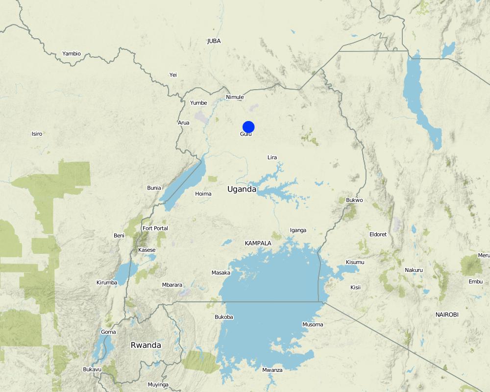
Gulu district.
awac sub county, paromo parish, gwengdiya village.
Uganda
Name of project which facilitated the documentation/ evaluation of the Technology (if relevant)
Scaling-up SLM practices by smallholder farmers (IFAD)Name of the institution(s) which facilitated the documentation/ evaluation of the Technology (if relevant)
Uganda Landcare Network (ULN) - Uganda1.3 Conditions regarding the use of data documented through WOCAT
When were the data compiled (in the field)?
25/05/2017
The compiler and key resource person(s) accept the conditions regarding the use of data documented through WOCAT:
Yes
1.4 Declaration on sustainability of the described Technology
Is the Technology described here problematic with regard to land degradation, so that it cannot be declared a sustainable land management technology?
No
Comments:
contour ploughing conserves soil from land degradation by erosion.
2. Description of the SLM Technology
2.1 Short description of the Technology
Definition of the Technology:
Contour farming is a practice of ploughing and/or planting across a slope following its elevation contour lines. The contour lines create a water break which reduces rill and gully forms of soil erosion in case of heavy storms. The water break allows more time for more water to percolate/sink into the soil, thus reducing the amount of water left to run off the surface.
2.2 Detailed description of the Technology
Description:
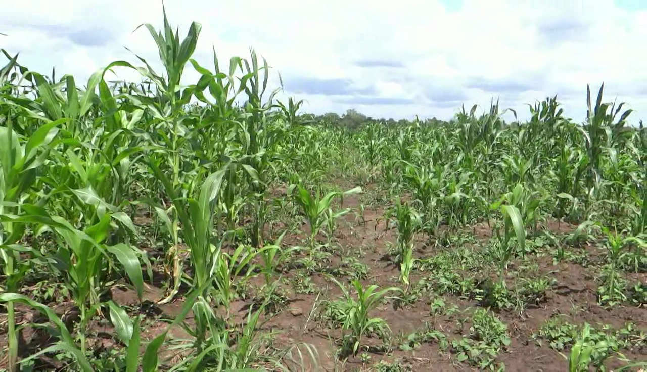
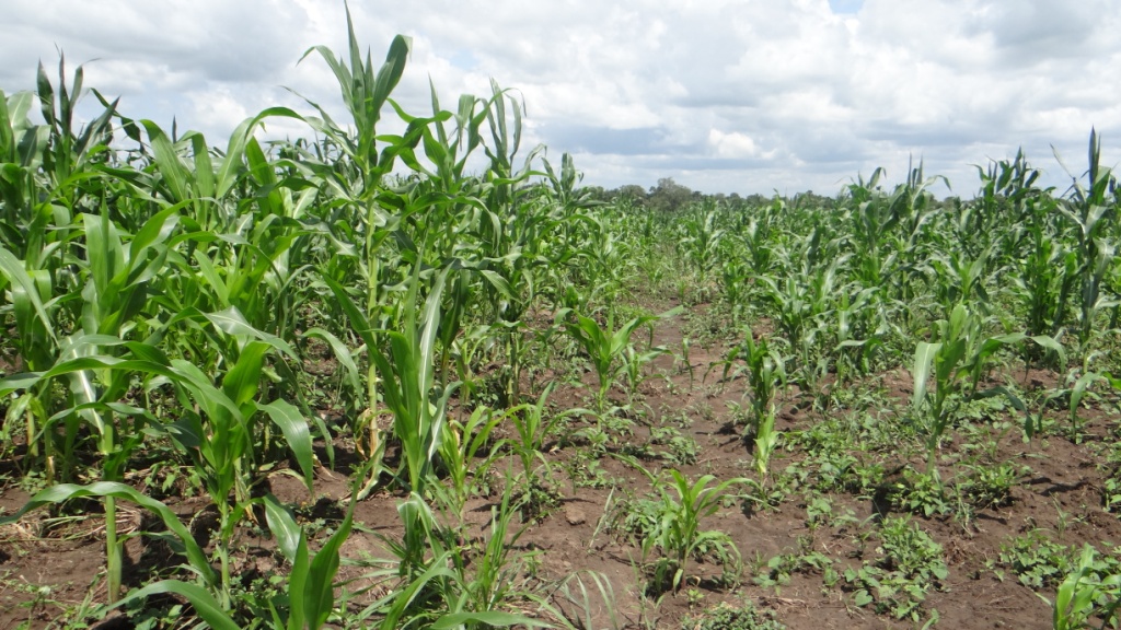
Improved Maize variety (Longe 10) is popularly grown in Northern Uganda due to its high yielding ability. Northern Uganda has a generally flat landscape although along the river banks it is slopy with high risk of soil erosion. This has motivated the land user to grow his maize along the slope using contour ploughing which is a sustainable land management practice. Contour farming is a practice of ploughing and/or planting across a slope following its elevation contour lines. The contour lines create a water break which reduces rill and gully forms of soil erosion in case of heavy storms. The water break allows more time for more water to percolate/sink into the soil, thus reducing the amount of water left to run off the surface. Northern Uganda has a tropical savanna climate with one growing season. Rainfall is usually moderate ranging from 1000-1500 mm per annum and sometimes occurs with heavy storms. Rainfall is received from April to November with a dry spell in June and July which affects crop growth.
The maize was grown for commercial purposes in a 25 x 25 acres of land on contour lines with the aim of controlling soil erosion, and increase plant nutrients, soil moisture, productivity and household income. The maize is planted along the contour lines at a spacing of 30 cm between the maize plants and of 1 meter between the rows that runs across the contour field. Holes for planting maize are dug at a depth of 30 cm along the contours with four maize seeds planted per hole and covered with soil immediately since the contours creates a water break which reduces the formation of rills and gullies during heavy water run-off which is a major cause of soil erosion.
The activities involved in establishing such a technology include clearing the field during the dry season in March and second ploughing in early April to alter the soil and allow proper decomposition of the grass and also creating contours during planting in early April at the onset of the rainy season. Weeding is done twice, first two weeks after maize germination in late April, and lastly in June.
Inputs needed to establish the technology include ox-plough, hoes, and pangas used to clear the field. Inputs for maintaining the technology include hoes for weeding the maize crop and also checking that the contours are not destroyed by the run-off.
The technology is liked because it is good at controlling soil erosion on the gently sloping field, increases plant nutrients and soil moisture, and increases productivity. But it is disadvantageous when contours collapse which is accelerating the speed of surface run-off.
2.3 Photos of the Technology
Media Gallery
2.4 Videos of the Technology
Comments, short description:
maize field along contour lines
Date:
25/05/2017
Location:
Gulu district
Name of videographer:
Betty Adoch
2.5 Country/ region/ locations where the Technology has been applied and which are covered by this assessment
Country:
Uganda
Region/ State/ Province:
Northern Uganda.
Further specification of location:
Gulu district
Comments:
GPS points shows the maize field
Map
×2.6 Date of implementation
If precise year is not known, indicate approximate date:
- less than 10 years ago (recently)
2.7 Introduction of the Technology
Specify how the Technology was introduced:
- through land users' innovation
Comments (type of project, etc.):
The land user visited other farmers and copied the ideas of contour ploughing. These farmers include Sam Kolo, Otema Awany amongst others.
3. Classification of the SLM Technology
3.1 Main purpose(s) of the Technology
- improve production
- reduce, prevent, restore land degradation
- adapt to climate change/ extremes and its impacts
- create beneficial economic impact
- create beneficial social impact
3.2 Current land use type(s) where the Technology is applied

Cropland
- Annual cropping
Main crops (cash and food crops):
maize
Comments:
contours prevent soil erosion by surface runoff
If land use has changed due to the implementation of the Technology, indicate land use before implementation of the Technology:
uncultivated land
3.3 Further information about land use
Water supply for the land on which the Technology is applied:
- rainfed
Number of growing seasons per year:
- 1
3.4 SLM group to which the Technology belongs
- minimal soil disturbance
- integrated soil fertility management
3.5 Spread of the Technology
Specify the spread of the Technology:
- evenly spread over an area
If the Technology is evenly spread over an area, indicate approximate area covered:
- < 0.1 km2 (10 ha)
3.6 SLM measures comprising the Technology

agronomic measures
- A1: Vegetation/ soil cover
- A2: Organic matter/ soil fertility
- A3: Soil surface treatment
- A5: Seed management, improved varieties
Comments:
this technology improves soil nutrients and results in higher yields
3.7 Main types of land degradation addressed by the Technology

soil erosion by water
- Wt: loss of topsoil/ surface erosion
- Wg: gully erosion/ gullying
3.8 Prevention, reduction, or restoration of land degradation
Specify the goal of the Technology with regard to land degradation:
- prevent land degradation
- reduce land degradation
Comments:
contour maize growing promotes sustainable land utilisation
4. Technical specifications, implementation activities, inputs, and costs
4.1 Technical drawing of the Technology
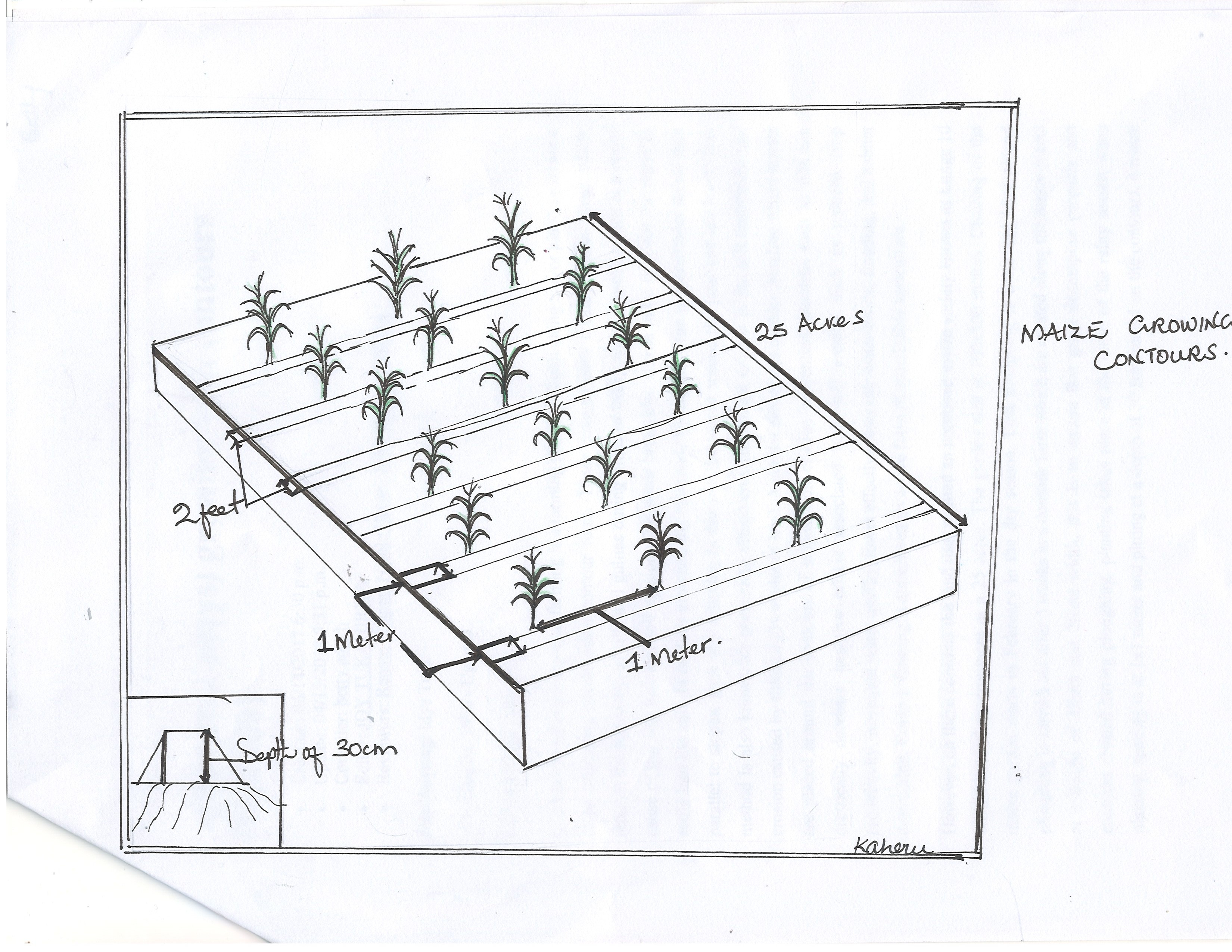
Author:
Betty Adoch.
Date:
25/05/2017
4.2 Technical specifications/ explanations of technical drawing
Contours are created on a gentle slope using ox-plough. Maize holes are dug at a depth of 30 cm and a spacing of 30 x 30 cm. The distance between the contours are 1 x 1 meter. The contours are helpful in improving infiltration rates and controlling soil erosion.
4.3 General information regarding the calculation of inputs and costs
Specify how costs and inputs were calculated:
- per Technology area
Indicate size and area unit:
25 acres
other/ national currency (specify):
UGX
Indicate average wage cost of hired labour per day:
5000 shs
4.4 Establishment activities
| Activity | Type of measure | Timing | |
|---|---|---|---|
| 1. | Clearing garden | Agronomic | March |
| 2. | Ox-ploughing to create contours | Agronomic | April |
| 3. | Planting | Agronomic | April |
| 4. | Weeding | Agronomic | Late April |
| 5. | Thinning | Agronomic | Late April |
Comments:
Easy to establish the contours.
4.5 Costs and inputs needed for establishment
| Specify input | Unit | Quantity | Costs per Unit | Total costs per input | % of costs borne by land users | |
|---|---|---|---|---|---|---|
| Labour | Clearing land | days | 30.0 | 5000.0 | 150000.0 | 100.0 |
| Labour | Ox-ploughing | days | 5.0 | 40000.0 | 200000.0 | 100.0 |
| Equipment | Ox-plough | pices | 5.0 | 20000.0 | 100000.0 | 100.0 |
| Equipment | Hoes for digging left over grass | pices | 10.0 | 12000.0 | 120000.0 | 100.0 |
| Equipment | Pangas for cutting tress in the field | pices | 10.0 | 12000.0 | 120000.0 | 100.0 |
| Plant material | Seedlings | kgs | 150.0 | 6000.0 | 900000.0 | 100.0 |
| Total costs for establishment of the Technology | 1590000.0 | |||||
If land user bore less than 100% of costs, indicate who covered the remaining costs:
no one
4.6 Maintenance/ recurrent activities
| Activity | Type of measure | Timing/ frequency | |
|---|---|---|---|
| 1. | Weeding | Agronomic | Late April |
| 2. | Thinning | Agronomic | Late April |
4.7 Costs and inputs needed for maintenance/ recurrent activities (per year)
| Specify input | Unit | Quantity | Costs per Unit | Total costs per input | % of costs borne by land users | |
|---|---|---|---|---|---|---|
| Labour | Weeding | days | 10.0 | 5000.0 | 50000.0 | 100.0 |
| Labour | Thining | days | 10.0 | 5000.0 | 50000.0 | 100.0 |
| Total costs for maintenance of the Technology | 100000.0 | |||||
If land user bore less than 100% of costs, indicate who covered the remaining costs:
No one
4.8 Most important factors affecting the costs
Describe the most determinate factors affecting the costs:
High costs of weeding and thinning the crop.
5. Natural and human environment
5.1 Climate
Annual rainfall
- < 250 mm
- 251-500 mm
- 501-750 mm
- 751-1,000 mm
- 1,001-1,500 mm
- 1,501-2,000 mm
- 2,001-3,000 mm
- 3,001-4,000 mm
- > 4,000 mm
Specify average annual rainfall (if known), in mm:
1000.00
Specifications/ comments on rainfall:
Rainfall is heavy in the months of April, May, August, September and October. This facilitates crop growth.
Indicate the name of the reference meteorological station considered:
Gulu weather station.
Agro-climatic zone
- sub-humid
Tropical savanna climate
5.2 Topography
Slopes on average:
- flat (0-2%)
- gentle (3-5%)
- moderate (6-10%)
- rolling (11-15%)
- hilly (16-30%)
- steep (31-60%)
- very steep (>60%)
Landforms:
- plateau/plains
- ridges
- mountain slopes
- hill slopes
- footslopes
- valley floors
Altitudinal zone:
- 0-100 m a.s.l.
- 101-500 m a.s.l.
- 501-1,000 m a.s.l.
- 1,001-1,500 m a.s.l.
- 1,501-2,000 m a.s.l.
- 2,001-2,500 m a.s.l.
- 2,501-3,000 m a.s.l.
- 3,001-4,000 m a.s.l.
- > 4,000 m a.s.l.
Indicate if the Technology is specifically applied in:
- convex situations
Comments and further specifications on topography:
Gently sloped landscapes
5.3 Soils
Soil depth on average:
- very shallow (0-20 cm)
- shallow (21-50 cm)
- moderately deep (51-80 cm)
- deep (81-120 cm)
- very deep (> 120 cm)
Soil texture (topsoil):
- medium (loamy, silty)
Soil texture (> 20 cm below surface):
- medium (loamy, silty)
Topsoil organic matter:
- medium (1-3%)
5.4 Water availability and quality
Ground water table:
5-50 m
Availability of surface water:
good
Water quality (untreated):
good drinking water
Is water salinity a problem?
No
Is flooding of the area occurring?
No
Comments and further specifications on water quality and quantity:
fresh water is suitable for human consumption
5.5 Biodiversity
Species diversity:
- medium
Habitat diversity:
- medium
5.6 Characteristics of land users applying the Technology
Sedentary or nomadic:
- Sedentary
Market orientation of production system:
- mixed (subsistence/ commercial
Off-farm income:
- 10-50% of all income
Relative level of wealth:
- average
Individuals or groups:
- individual/ household
Level of mechanization:
- manual work
Gender:
- women
- men
Age of land users:
- middle-aged
Indicate other relevant characteristics of the land users:
.
5.7 Average area of land owned or leased by land users applying the Technology
- < 0.5 ha
- 0.5-1 ha
- 1-2 ha
- 2-5 ha
- 5-15 ha
- 15-50 ha
- 50-100 ha
- 100-500 ha
- 500-1,000 ha
- 1,000-10,000 ha
- > 10,000 ha
Is this considered small-, medium- or large-scale (referring to local context)?
- medium-scale
5.8 Land ownership, land use rights, and water use rights
Land ownership:
- individual, not titled
Land use rights:
- individual
Water use rights:
- communal (organized)
5.9 Access to services and infrastructure
health:
- poor
- moderate
- good
education:
- poor
- moderate
- good
technical assistance:
- poor
- moderate
- good
employment (e.g. off-farm):
- poor
- moderate
- good
markets:
- poor
- moderate
- good
energy:
- poor
- moderate
- good
roads and transport:
- poor
- moderate
- good
drinking water and sanitation:
- poor
- moderate
- good
financial services:
- poor
- moderate
- good
6. Impacts and concluding statements
6.1 On-site impacts the Technology has shown
Socio-economic impacts
Production
crop production
Quantity before SLM:
low
Quantity after SLM:
high
Comments/ specify:
SLM knowledge gained
crop quality
Quantity before SLM:
low
Quantity after SLM:
high
Comments/ specify:
SLM knowledge acquired
Income and costs
farm income
Quantity before SLM:
low
Quantity after SLM:
high
Comments/ specify:
proper method of farming leading to increased yield and income through SLM knowledge
Socio-cultural impacts
food security/ self-sufficiency
Quantity before SLM:
low
Quantity after SLM:
high
Comments/ specify:
knowledge of SLM leading to increased yield
SLM/ land degradation knowledge
Quantity before SLM:
low
Quantity after SLM:
high
Comments/ specify:
proper method of farming along a gentle slope using contours
Ecological impacts
Water cycle/ runoff
harvesting/ collection of water
Quantity before SLM:
low
Quantity after SLM:
high
Comments/ specify:
water is collected in the trenches between the contours increasing the infiltration rates and leading to high moisture content in the soil.
surface runoff
Quantity before SLM:
high
Quantity after SLM:
low
Comments/ specify:
the contours reduce the high rate of surface run-off.
Soil
soil moisture
Quantity before SLM:
low
Quantity after SLM:
high
Comments/ specify:
high soil moisture due to high rate of infiltration along contour lines
soil loss
Quantity before SLM:
high
Quantity after SLM:
low
Comments/ specify:
contours reduces the rate of soil loss through erosion.
6.2 Off-site impacts the Technology has shown
downstream siltation
Quantity before SLM:
high
Quantity after SLM:
low
Comments/ specify:
the low rate of soil erosion along the contours reduces sediment deposition downstream.
6.3 Exposure and sensitivity of the Technology to gradual climate change and climate-related extremes/ disasters (as perceived by land users)
Gradual climate change
Gradual climate change
| Season | Type of climatic change/ extreme | How does the Technology cope with it? | |
|---|---|---|---|
| annual temperature | increase | moderately | |
| annual rainfall | decrease | moderately | |
| seasonal rainfall | wet/ rainy season | decrease | moderately |
Climate-related extremes (disasters)
Meteorological disasters
| How does the Technology cope with it? | |
|---|---|
| tropical storm | moderately |
Climatological disasters
| How does the Technology cope with it? | |
|---|---|
| heatwave | moderately |
| drought | moderately |
6.4 Cost-benefit analysis
How do the benefits compare with the establishment costs (from land users’ perspective)?
Short-term returns:
positive
Long-term returns:
positive
How do the benefits compare with the maintenance/ recurrent costs (from land users' perspective)?
Short-term returns:
positive
Long-term returns:
positive
6.5 Adoption of the Technology
- 10-50%
If available, quantify (no. of households and/ or area covered):
50
Of all those who have adopted the Technology, how many have did so spontaneously, i.e. without receiving any material incentives/ payments?
- 10-50%
6.6 Adaptation
Has the Technology been modified recently to adapt to changing conditions?
Yes
If yes, indicate to which changing conditions it was adapted:
- climatic change/ extremes
Specify adaptation of the Technology (design, material/ species, etc.):
improved maize variety longe 10
6.7 Strengths/ advantages/ opportunities of the Technology
| Strengths/ advantages/ opportunities in the land user’s view |
|---|
| source of food |
| source of income |
| Strengths/ advantages/ opportunities in the compiler’s or other key resource person’s view |
|---|
| creates social interactions |
| promote food security |
6.8 Weaknesses/ disadvantages/ risks of the Technology and ways of overcoming them
| Weaknesses/ disadvantages/ risks in the land user’s view | How can they be overcome? |
|---|---|
| drought prone | water harvesting within the garden |
| take long to mature | adapt fast maturing maize variety |
| Weaknesses/ disadvantages/ risks in the compiler’s or other key resource person’s view | How can they be overcome? |
|---|---|
| pests and diseases | weeding and spraying to be done |
7. References and links
7.1 Methods/ sources of information
- field visits, field surveys
1
- interviews with land users
1
Links and modules
Expand all Collapse allLinks
No links
Modules
No modules