Irrigation branch canals in acid sulfate soils [Thailand]
- Creation:
- Update:
- Compiler: Bunjirtluk Jintaridth
- Editor: –
- Reviewers: Rima Mekdaschi Studer, Pitayakon Limtong, William Critchley
-
technologies_4223 - Thailand
View sections
Expand all Collapse all1. General information
1.2 Contact details of resource persons and institutions involved in the assessment and documentation of the Technology
Key resource person(s)
land user:
1.3 Conditions regarding the use of data documented through WOCAT
The compiler and key resource person(s) accept the conditions regarding the use of data documented through WOCAT:
Yes
1.4 Declaration on sustainability of the described Technology
Is the Technology described here problematic with regard to land degradation, so that it cannot be declared a sustainable land management technology?
No
2. Description of the SLM Technology
2.1 Short description of the Technology
Definition of the Technology:
1.To use water in branch canals to supply irrigation water and alternately to leach soil acidity and reduce expenses in managing soil and water 2. The ditch ridge is used as a pathway for agricultural materials and equipment.
2.2 Detailed description of the Technology
Description:
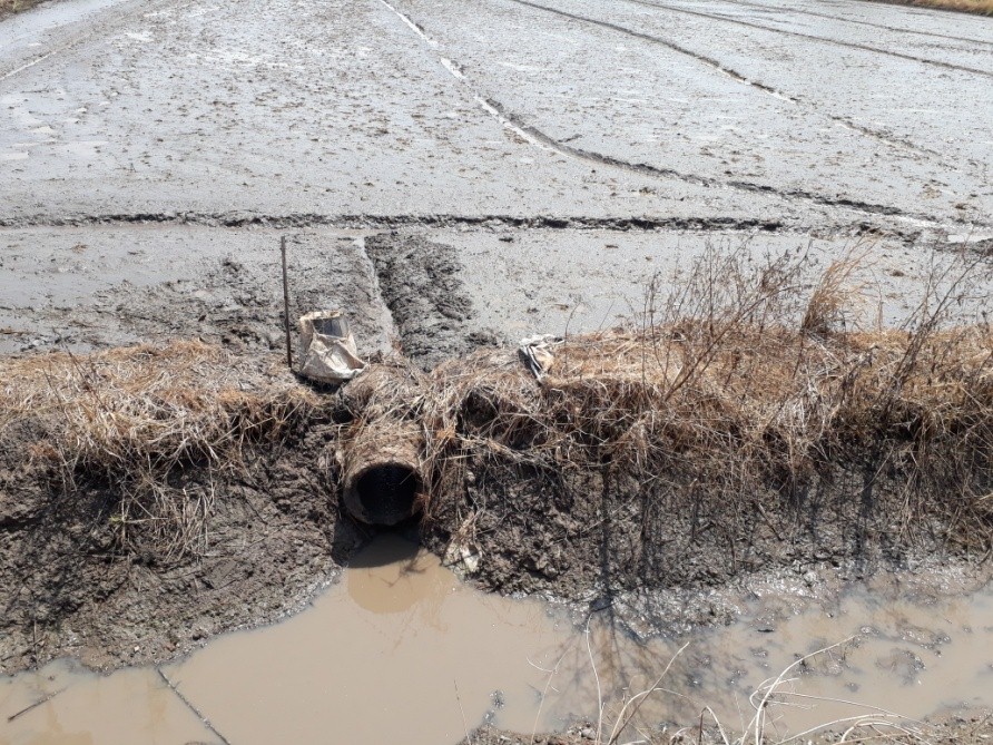
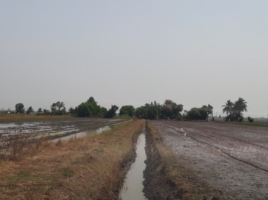
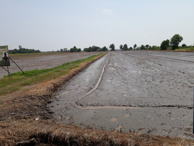
Establishing the system of water drainage ditches - Lampradong Rongnam (irrigation branch canals) is the technology developed from struggling in managing water and soil for farming before 1993. Learning to modify the system was derived from using the labor required to move pumps and equipment to pump water at various locations. This created an exhausting and time-consuming task. Moreover, land could not be developed and the water could not be controlled as required either. Therefore, setting up a system of irrigation branch canals arose from this. The system was then designed to counter acidity and neutralized it from the soil. As a result, rice could be grown, giving a good yield. At the same time, water could be controlled in rice farming throughout. To set up a ditch-branch watercourse comprises ditches of 50-100 centimetres wide, and 100 centimetres deep. Both sides of the ditch consist of ridges that can be modified -either side- to be a path to deliver materials and equipment in doing rice farming and productivity form the paddy. The path to convey materials is 1.9 -2.5 meters up, depending the objectives of the owner of the area. For the levee on the other side, it is 50-100 centimetres wide with a height of 50 centimetres. In the rice farming area of farmers in Ongkharak district, Nakhon Nayok province, there are paddy areas divided into plots. Each plot has an area of 3.2-6.4 hectares. The areas required to establish these canals are about 1,640-3,200 square meters. Farmers not only prefer this adapted technology but it also reduces labour in managing rice farming.
2.3 Photos of the Technology
Media Gallery
2.5 Country/ region/ locations where the Technology has been applied and which are covered by this assessment
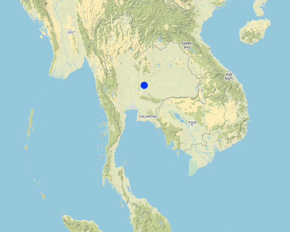
Country:
Thailand
Region/ State/ Province:
Nakhon Nayok
Further specification of location:
Ongkharak district
Is/are the technology site(s) located in a permanently protected area?
No
Map
×2.6 Date of implementation
If precise year is not known, indicate approximate date:
- 10-50 years ago
2.7 Introduction of the Technology
Specify how the Technology was introduced:
- through land users' innovation
Comments (type of project, etc.):
Establishing the system of irrigation branch canals Lampradong Rongnam is the technology developed from struggling in managing water and soil for doing farming in 1993.
3. Classification of the SLM Technology
3.1 Main purpose(s) of the Technology
- improve production
- reduce, prevent, restore land degradation
- conserve ecosystem
- create beneficial economic impact
- create beneficial social impact
3.2 Current land use type(s) where the Technology is applied
Land use mixed within the same land unit:
No

Cropland
- Annual cropping
Annual cropping - Specify crops:
- cereals - rice (wetland)
Number of growing seasons per year:
- 2
Is intercropping practiced?
No
Is crop rotation practiced?
No

Waterways, waterbodies, wetlands
- Drainage lines, waterways
Main products/ services:
To control the water level when operating rice farming, and the wide ridge is used to transport agricultural materials and equipment, and to manage farm operations conveniently and quickly.
3.3 Has land use changed due to the implementation of the Technology?
Has land use changed due to the implementation of the Technology?
- No (Continue with question 3.4)
3.4 Water supply
Water supply for the land on which the Technology is applied:
- full irrigation
3.5 SLM group to which the Technology belongs
- irrigation management (incl. water supply, drainage)
- wetland protection/ management
3.6 SLM measures comprising the Technology

structural measures
- S3: Graded ditches, channels, waterways
- S7: Water harvesting/ supply/ irrigation equipment
- S10: Energy saving measures

management measures
- M4: Major change in timing of activities
3.7 Main types of land degradation addressed by the Technology

chemical soil deterioration
- Ca: acidification
3.8 Prevention, reduction, or restoration of land degradation
Specify the goal of the Technology with regard to land degradation:
- reduce land degradation
4. Technical specifications, implementation activities, inputs, and costs
4.1 Technical drawing of the Technology
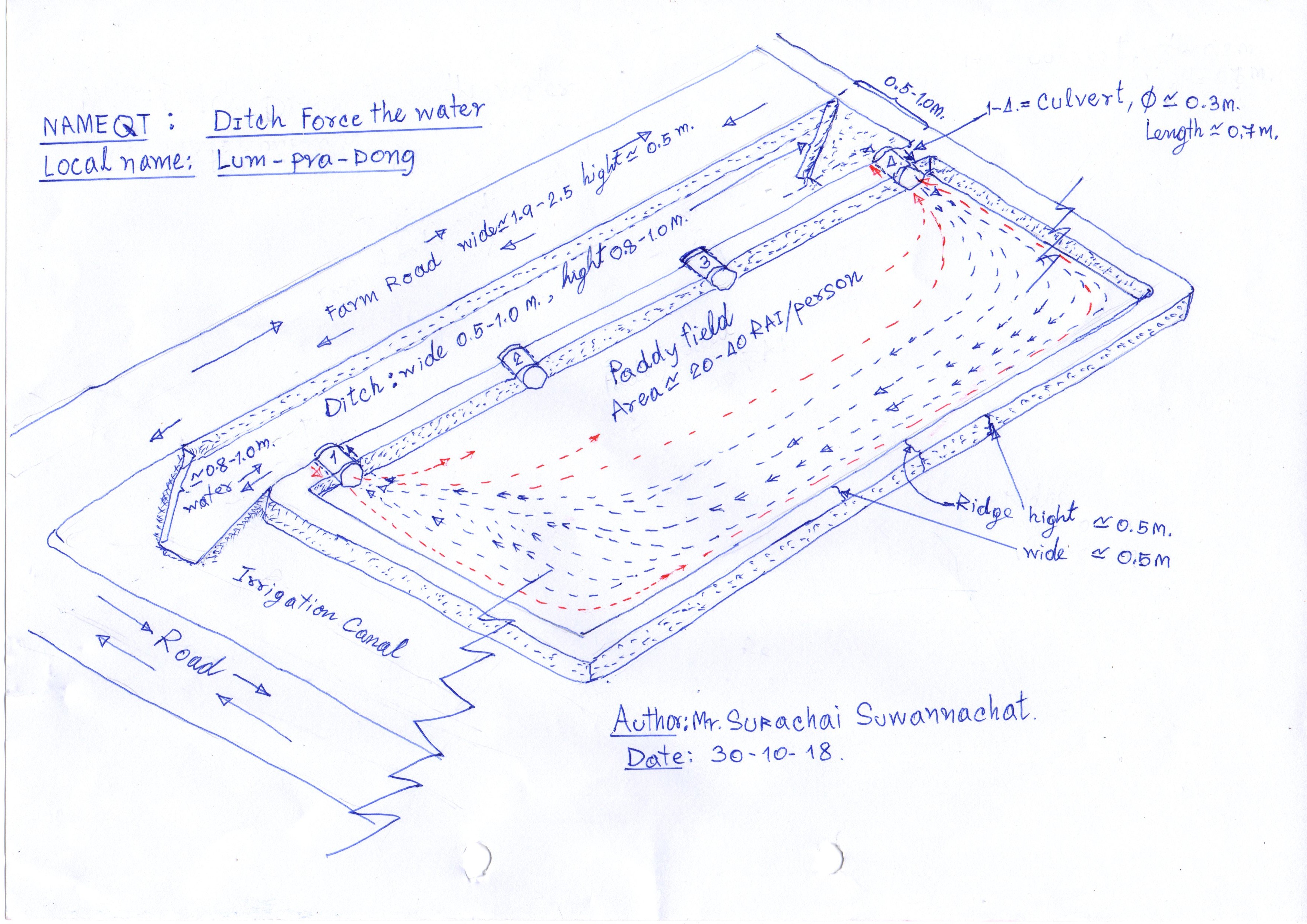
Technical specifications (related to technical drawing):
Water-directing ditches-Lampradong Rongnam (irrigation branch canals-watercourse)
Author:
Mr. Surachai Suwannachart
Date:
12/11/2018
4.2 General information regarding the calculation of inputs and costs
Specify how costs and inputs were calculated:
- per Technology area
Indicate size and area unit:
1-2 ha
Specify currency used for cost calculations:
- USD
Indicate average wage cost of hired labour per day:
10
4.3 Establishment activities
| Activity | Timing (season) | |
|---|---|---|
| 1. | Plowing | before on-set of rains |
| 2. | pumping water in the paddy field | before on-set of rains |
| 3. | making soil to become muddy | before on-set of rains |
| 4. | sowing rice seeds | before on-set of rains |
| 5. | pumping water out | before on-set of rains |
| 6. | pumping water in | before on-set of rains |
4.4 Costs and inputs needed for establishment
| Specify input | Unit | Quantity | Costs per Unit | Total costs per input | % of costs borne by land users | |
|---|---|---|---|---|---|---|
| Labour | Cost of drilling and the equipment of the water-delivery ditch | person-days | 1.0 | 183.0 | 183.0 | 100.0 |
| Labour | Cost of dredging once per 3-5 years, each time costs | person-days | 1.0 | 166.0 | 166.0 | 100.0 |
| Equipment | oil used in harvesting | hectare | 1.0 | 3.5 | 3.5 | 100.0 |
| Plant material | sowing rice seeds | hectare | 1.0 | 0.6 | 0.6 | 100.0 |
| Plant material | harvesting | hectare | 1.0 | 3.2 | 3.2 | 100.0 |
| Plant material | transporting paddy | hectare | 1.0 | 1.25 | 1.25 | 100.0 |
| Fertilizers and biocides | applying fertilizers | hectare | 1.0 | 0.625 | 0.63 | 100.0 |
| Fertilizers and biocides | spraying chemicals | hectare | 1.0 | 3.4 | 3.4 | 100.0 |
| Fertilizers and biocides | oil used in pumping water into the paddy | hectare | 1.0 | 0.15 | 0.15 | 100.0 |
| Construction material | plowing | hectare | 1.0 | 1.56 | 1.56 | 100.0 |
| Construction material | pumping water in the paddy field | hectare | 1.0 | 0.15 | 0.15 | 100.0 |
| Construction material | making soil become muddy | hectare | 1.0 | 0.156 | 0.16 | 100.0 |
| Construction material | pumping water in | hectare | 1.0 | 0.15 | 0.15 | 100.0 |
| Construction material | pumping water out | hectare | 1.0 | 0.15 | 0.15 | 100.0 |
| Total costs for establishment of the Technology | 363.9 | |||||
| Total costs for establishment of the Technology in USD | 363.9 | |||||
Comments:
Not subsidised
4.5 Maintenance/ recurrent activities
| Activity | Timing/ frequency | |
|---|---|---|
| 1. | Annual maintenance | 1 |
Comments:
cost per 3 years
4.6 Costs and inputs needed for maintenance/ recurrent activities (per year)
| Specify input | Unit | Quantity | Costs per Unit | Total costs per input | % of costs borne by land users | |
|---|---|---|---|---|---|---|
| Labour | Annual cost of maintenance | person-days | 1.0 | 33.0 | 33.0 | 100.0 |
| Total costs for maintenance of the Technology | 33.0 | |||||
| Total costs for maintenance of the Technology in USD | 33.0 | |||||
4.7 Most important factors affecting the costs
Describe the most determinate factors affecting the costs:
current labor costs
5. Natural and human environment
5.1 Climate
Annual rainfall
- < 250 mm
- 251-500 mm
- 501-750 mm
- 751-1,000 mm
- 1,001-1,500 mm
- 1,501-2,000 mm
- 2,001-3,000 mm
- 3,001-4,000 mm
- > 4,000 mm
Agro-climatic zone
- sub-humid
5.2 Topography
Slopes on average:
- flat (0-2%)
- gentle (3-5%)
- moderate (6-10%)
- rolling (11-15%)
- hilly (16-30%)
- steep (31-60%)
- very steep (>60%)
Landforms:
- plateau/plains
- ridges
- mountain slopes
- hill slopes
- footslopes
- valley floors
Altitudinal zone:
- 0-100 m a.s.l.
- 101-500 m a.s.l.
- 501-1,000 m a.s.l.
- 1,001-1,500 m a.s.l.
- 1,501-2,000 m a.s.l.
- 2,001-2,500 m a.s.l.
- 2,501-3,000 m a.s.l.
- 3,001-4,000 m a.s.l.
- > 4,000 m a.s.l.
5.3 Soils
Soil depth on average:
- very shallow (0-20 cm)
- shallow (21-50 cm)
- moderately deep (51-80 cm)
- deep (81-120 cm)
- very deep (> 120 cm)
Soil texture (topsoil):
- medium (loamy, silty)
Soil texture (> 20 cm below surface):
- medium (loamy, silty)
Topsoil organic matter:
- high (>3%)
5.4 Water availability and quality
Ground water table:
5-50 m
Availability of surface water:
good
Water quality (untreated):
for agricultural use only (irrigation)
Water quality refers to:
surface water
Is water salinity a problem?
No
Is flooding of the area occurring?
Yes
5.5 Biodiversity
Species diversity:
- medium
Habitat diversity:
- medium
5.6 Characteristics of land users applying the Technology
Sedentary or nomadic:
- Sedentary
Market orientation of production system:
- subsistence (self-supply)
Off-farm income:
- less than 10% of all income
Relative level of wealth:
- average
Individuals or groups:
- individual/ household
Level of mechanization:
- mechanized/ motorized
Gender:
- men
Age of land users:
- middle-aged
5.7 Average area of land used by land users applying the Technology
- < 0.5 ha
- 0.5-1 ha
- 1-2 ha
- 2-5 ha
- 5-15 ha
- 15-50 ha
- 50-100 ha
- 100-500 ha
- 500-1,000 ha
- 1,000-10,000 ha
- > 10,000 ha
Is this considered small-, medium- or large-scale (referring to local context)?
- medium-scale
5.8 Land ownership, land use rights, and water use rights
Land ownership:
- individual, titled
Land use rights:
- individual
Water use rights:
- individual
Are land use rights based on a traditional legal system?
Yes
5.9 Access to services and infrastructure
health:
- poor
- moderate
- good
education:
- poor
- moderate
- good
technical assistance:
- poor
- moderate
- good
employment (e.g. off-farm):
- poor
- moderate
- good
markets:
- poor
- moderate
- good
energy:
- poor
- moderate
- good
roads and transport:
- poor
- moderate
- good
drinking water and sanitation:
- poor
- moderate
- good
financial services:
- poor
- moderate
- good
6. Impacts and concluding statements
6.1 On-site impacts the Technology has shown
Socio-economic impacts
Production
crop production
Quantity before SLM:
2.8 tons per ha
Quantity after SLM:
7.5 tons per ha
production area
land management
energy generation
Comments/ specify:
Reduced pumping required
Water availability and quality
irrigation water availability
Socio-cultural impacts
food security/ self-sufficiency
health situation
community institutions
SLM/ land degradation knowledge
situation of socially and economically disadvantaged groups
Ecological impacts
Soil
soil moisture
acidity
6.2 Off-site impacts the Technology has shown
water availability
reliable and stable stream flows in dry season
downstream flooding
downstream siltation
buffering/ filtering capacity
wind transported sediments
6.3 Exposure and sensitivity of the Technology to gradual climate change and climate-related extremes/ disasters (as perceived by land users)
Other climate-related consequences
Other climate-related consequences
| How does the Technology cope with it? | |
|---|---|
| extended growing period | moderately |
| sea level rise | not known |
6.4 Cost-benefit analysis
How do the benefits compare with the establishment costs (from land users’ perspective)?
Short-term returns:
positive
Long-term returns:
positive
How do the benefits compare with the maintenance/ recurrent costs (from land users' perspective)?
Short-term returns:
positive
Long-term returns:
positive
6.5 Adoption of the Technology
- > 50%
Of all those who have adopted the Technology, how many did so spontaneously, i.e. without receiving any material incentives/ payments?
- 91-100%
6.6 Adaptation
Has the Technology been modified recently to adapt to changing conditions?
Yes
If yes, indicate to which changing conditions it was adapted:
- climatic change/ extremes
6.7 Strengths/ advantages/ opportunities of the Technology
| Strengths/ advantages/ opportunities in the land user’s view |
|---|
| Controlling the acidity or alkalinity of the soil to be at an appropriate level for rice cultivation. |
| Being able to wash off and control acidity/alkalinity of the soil so that it will not cause damages when operating rice farming, whereby rice yield increases. |
| Being able to grow short-lived crops after the rice harvest, which requires some water. |
| Strengths/ advantages/ opportunities in the compiler’s or other key resource person’s view |
|---|
| Reducing expenses, costs. Saving water, fertilizers and chemicals. |
| Reducing the time for transporting materials and equipment, paddy management and transportation of paddy products from the field. |
| Increasing the quantity and quality of farm products. |
| Being able to grow short-lived crops after the rice harvest, which requires some water. |
| Social and cultural aspects such as food security, self-reliance, health, rights to use soil and water, community institutes, knowledge management and promoting capacities, social equality etc. |
| There are good values and cultures toward one another. There is no conflict regarding water because everyone has a ditch in one's own area for every plot. There is food security. They can use the land for rice cultivation more than once a year. |
| There is a water users group and there are organizations that pass on knowledge, conduct training, thus increasing the farmers’ ability in utilizing soil, water and plants. |
6.8 Weaknesses/ disadvantages/ risks of the Technology and ways of overcoming them
| Weaknesses/ disadvantages/ risks in the land user’s view | How can they be overcome? |
|---|---|
| There are losing parts of agricultural areas for water delivery ditches construction. | - |
7. References and links
7.1 Methods/ sources of information
- field visits, field surveys
4
- interviews with land users
2
- interviews with SLM specialists/ experts
1
- compilation from reports and other existing documentation
1
When were the data compiled (in the field)?
12/11/2018
7.2 References to available publications
Title, author, year, ISBN:
the establishment of Lampradong Rongnam-the irrigation ditch (watercourse)
Available from where? Costs?
The Learning Center at Village No. 3, Sisa Krabue sub-district, Ongkharak district, Nakhon Nayok
7.3 Links to relevant online information
Title/ description:
the establishment of Lampradong Rongnam-the irrigation ditch (watercourse)
URL:
http:\\www.1ldd.go.th/WEB_PSD/prnew/2561/sr1-61/sr2.pdf
Links and modules
Expand all Collapse allLinks
No links
Modules
No modules