Minimizing soil erosion through Natural Vegetative Strip (NVS) practice in slope cultivation [Bangladesh]
- Creation:
- Update:
- Compiler: Fazlay Arafat
- Editor: –
- Reviewers: Rima Mekdaschi Studer, Ursula Gaemperli
technologies_5504 - Bangladesh
View sections
Expand all Collapse all1. General information
1.2 Contact details of resource persons and institutions involved in the assessment and documentation of the Technology
Key resource person(s)
SLM specialist:
Islam Md. Mahbubul
Soil Conservation and Watershed Management Center
Bangladesh
SLM specialist:
Islam Md. Shahinul
Soil Conservation and Watershed Management Center
Bangladesh
1.3 Conditions regarding the use of data documented through WOCAT
The compiler and key resource person(s) accept the conditions regarding the use of data documented through WOCAT:
Yes
1.4 Declaration on sustainability of the described Technology
Is the Technology described here problematic with regard to land degradation, so that it cannot be declared a sustainable land management technology?
No
2. Description of the SLM Technology
2.1 Short description of the Technology
Definition of the Technology:
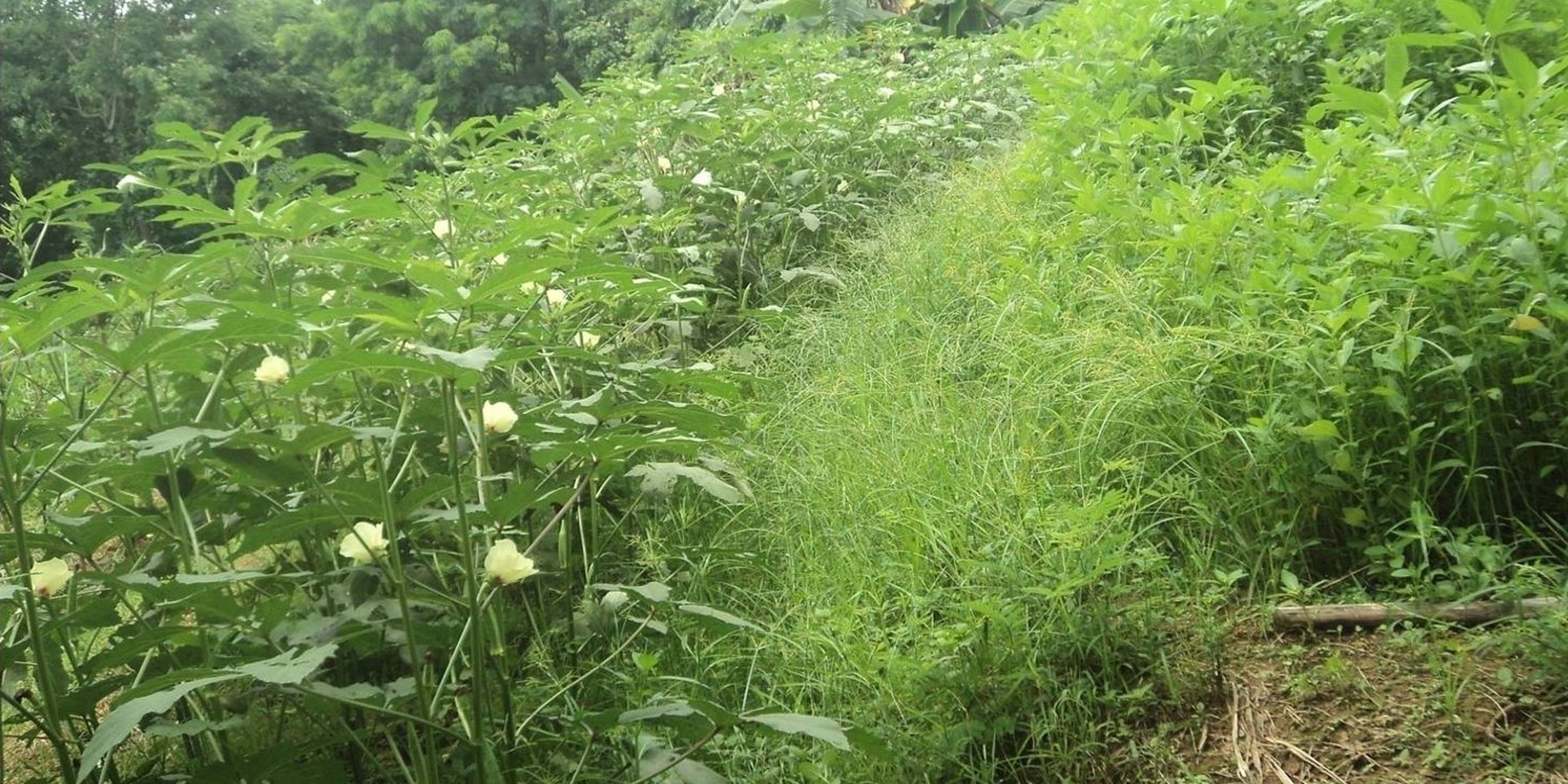
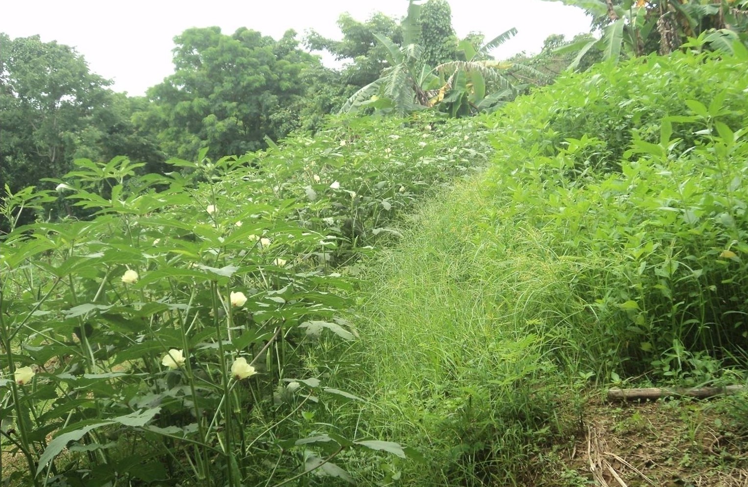
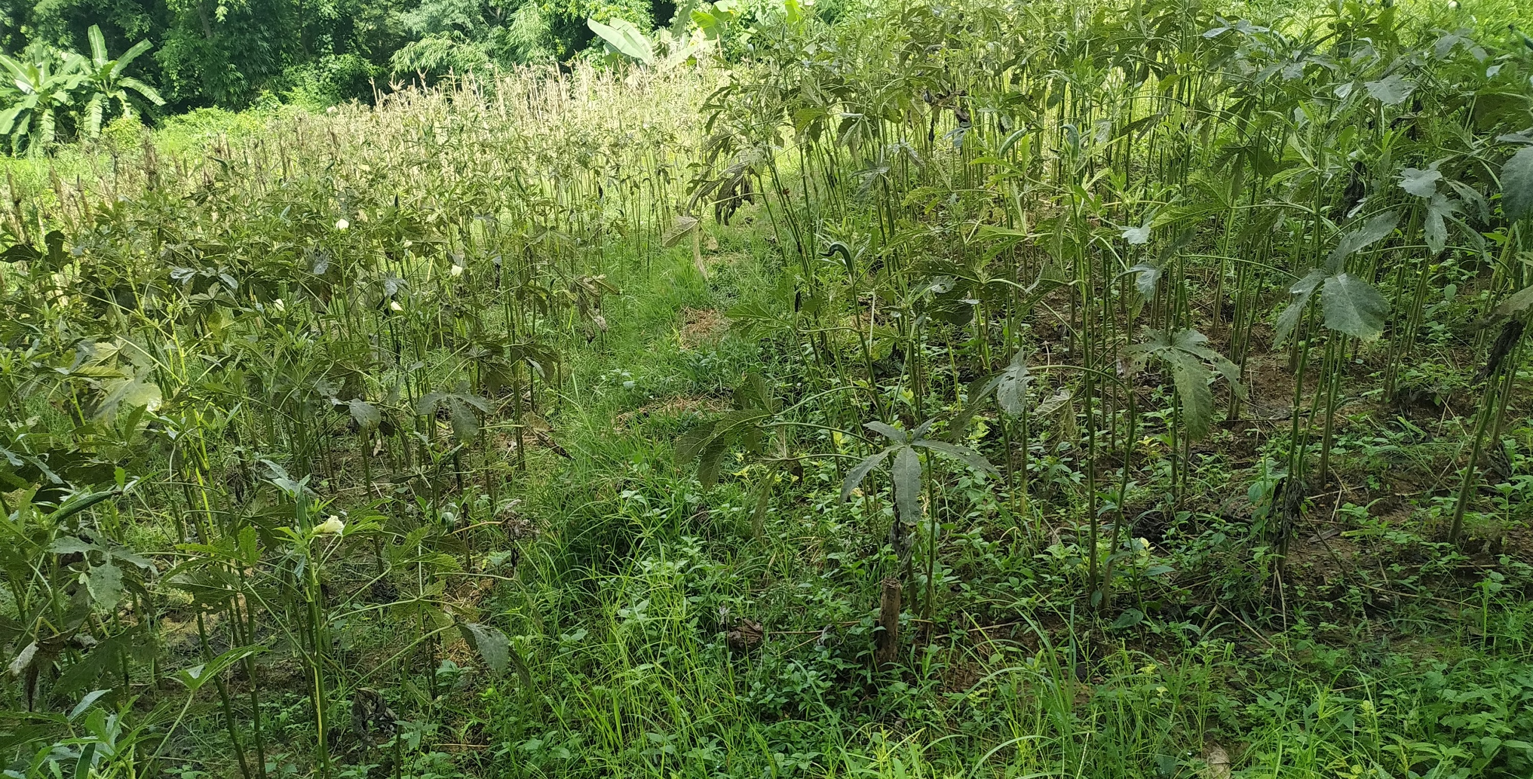
Natural Vegetative Strips (NVS) are narrow strips of naturally growing grasses and herbs intentionally left unploughed along the contours of slope land to serve as buffers that prevent soil erosion during heavy rains.
2.2 Detailed description of the Technology
Description:
The Chittagong Hill Tracts (CHT) covers an area about 13,181 km2 and occupies about 76% of total 12% upland areas of the country and is endowed with natural beauty and potential economic benefits. Shifting cultivation or jhum has been practiced in CHT for many hundreds of years by the local people. Shifting cultivation is a form of agriculture, in which an area of ground is cleared of vegetation, and cultivated for a few years and then abandoned for a new area until its fertility has been naturally restored. Many cultivators practice slash-and-burn in jhum as one element of their farming cycle. Shifting cultivation and its associated fires destroyed about two thirds of the previously existing forests in CHT, which has accelerated soil erosion. While it was an environmentally suitable land use in the past when population pressure was low, it has gradually become an environmentally incompatible land use system with the shortening of fallow periods. In addition to increasing population pressure, low investment in agricultural technology, and poor management of land rights have also negatively impacted the forests. One of the best ways of adapting to these issues is the adoption of Natural Vegetative Strip (NVS) technique on cultivated slopes.
NVS are narrow strips of naturally growing grasses and herbs intentionally left unploughed along the contours of hilly-sloped lands. On gentle slopes, every 4-meters a 1-meter wide strip of NVS is made along the natural contours of the slope. These strips serve as buffers that prevent the soil from eroding during heavy rains and intensive cultivation. Over time, these strips form stable terraces along the contours. Vegetables and other crops can be cultivated in between two NVS.
The Soil Conservation and Watershed Management Center in Meghla, Bandarban has implemented demonstration plots of this sustainable land management technique. Here the use of NVS has improved morphological and reproductive characteristics. They reduced soil erosion by more than 90% and NVS’s were easy to establish as they were incorporated during land preparation, and thus required minimal labour. They did not entail additional cost, as there was no need for additional planting materials, since the grasses naturally grew on the farm.
In addition to minimizing soil erosion, NVS plays a vital role in improving plant growth, crop productivity, and fruit length and weight. The strips also filter pesticides, nitrates and soluble phosphorus thus prevent runoff. As they improve water infiltration during heavy rains, subsequent land preparation and crop management become easier. One limitation of NVS is that it reduces the available cropping area by about 10 to 15%, depending on the steepness of the slope. The steeper slope require more wide vegetative strips for erosion protection. Typically the strips do not cause weed problems as long as the farmers regularly cultivate within the NVS area and maintain a 50 cm buffer around the area. If farmer-maintenance is good, no weed problems occur. NVS is a promising practice to mitigate soil erosion and improve crop cultivation in CHT.
2.3 Photos of the Technology
Media Gallery
2.5 Country/ region/ locations where the Technology has been applied and which are covered by this assessment
Country:
Bangladesh
Region/ State/ Province:
Bandarban District
Further specification of location:
Soil Conservation and Watershed Management Center, Meghla, Bandarban
Specify the spread of the Technology:
- evenly spread over an area
If precise area is not known, indicate approximate area covered:
- < 0.1 km2 (10 ha)
Is/are the technology site(s) located in a permanently protected area?
No
2.6 Date of implementation
If precise year is not known, indicate approximate date:
- less than 10 years ago (recently)
2.7 Introduction of the Technology
Specify how the Technology was introduced:
- during experiments/ research
Comments (type of project, etc.):
The Soil Conservation and Watershed Management Center demonstrate the NVS technology in hill slope of Bandarban area to study the impact of this practice on erosion.
3. Classification of the SLM Technology
3.1 Main purpose(s) of the Technology
- improve production
- reduce, prevent, restore land degradation
- reduce risk of disasters
3.2 Current land use type(s) where the Technology is applied
Land use mixed within the same land unit:
No

Cropland
- Annual cropping
Annual cropping - Specify crops:
- fodder crops - grasses
- legumes and pulses - beans
- vegetables - other
Number of growing seasons per year:
- 2
Specify:
Summer and Winter
Is intercropping practiced?
Yes
If yes, specify which crops are intercropped:
Yard-long bean and Okra
Is crop rotation practiced?
No
3.3 Has land use changed due to the implementation of the Technology?
Has land use changed due to the implementation of the Technology?
- No (Continue with question 3.4)
Comments:
Shifting cultivation practiced in the slopes through slush and burn which triggered extreme soil erosion
3.4 Water supply
Water supply for the land on which the Technology is applied:
- mixed rainfed-irrigated
Comments:
Manual irrigation in the dry period from the stream
3.5 SLM group to which the Technology belongs
- cross-slope measure
3.6 SLM measures comprising the Technology

vegetative measures
- V2: Grasses and perennial herbaceous plants
3.7 Main types of land degradation addressed by the Technology

soil erosion by water
- Wt: loss of topsoil/ surface erosion
3.8 Prevention, reduction, or restoration of land degradation
Specify the goal of the Technology with regard to land degradation:
- reduce land degradation
4. Technical specifications, implementation activities, inputs, and costs
4.1 Technical drawing of the Technology
Technical specifications (related to technical drawing):
Slope: 15-45%
NVS width: 1 meter. Along the natural contours of the slope
Cropping bed: 4 meter
Author:
Nazrin Sultana
4.2 General information regarding the calculation of inputs and costs
Specify how costs and inputs were calculated:
- per Technology area
Indicate size and area unit:
1 acre
If using a local area unit, indicate conversion factor to one hectare (e.g. 1 ha = 2.47 acres): 1 ha =:
1 acre = 0.4 ha
other/ national currency (specify):
BDT
If relevant, indicate exchange rate from USD to local currency (e.g. 1 USD = 79.9 Brazilian Real): 1 USD =:
84.0
Indicate average wage cost of hired labour per day:
600 BDT
4.3 Establishment activities
| Activity | Timing (season) | |
|---|---|---|
| 1. | Cleaning | March-April |
| 2. | Making contour line | March-April |
| 3. | Planting | April-May |
4.4 Costs and inputs needed for establishment
| Specify input | Unit | Quantity | Costs per Unit | Total costs per input | % of costs borne by land users | |
|---|---|---|---|---|---|---|
| Labour | Cleaning | person-days | 15.0 | 600.0 | 9000.0 | 100.0 |
| Labour | Making contour line | person-days | 8.0 | 600.0 | 4800.0 | 100.0 |
| Labour | Making pit | person-days | 8.0 | 600.0 | 4800.0 | 100.0 |
| Labour | Fertilizer application | person-days | 2.0 | 600.0 | 1200.0 | 100.0 |
| Equipment | Spade, Knife, Basket | lump sum | 1.0 | 5000.0 | 5000.0 | 100.0 |
| Plant material | Seeds of vegetables | kg | 0.6 | 4000.0 | 2400.0 | 100.0 |
| Plant material | Bamboo stick to support plant | pcs | 1500.0 | 2.0 | 3000.0 | 100.0 |
| Fertilizers and biocides | Urea | kg | 450.0 | 16.0 | 7200.0 | 100.0 |
| Fertilizers and biocides | TSP | kg | 150.0 | 22.0 | 3300.0 | 100.0 |
| Fertilizers and biocides | MoP | kg | 200.0 | 15.0 | 3000.0 | 100.0 |
| Fertilizers and biocides | Cow dung | lump sum | 1.0 | 5000.0 | 5000.0 | 100.0 |
| Fertilizers and biocides | pesticides | lump sum | 1.0 | 2000.0 | 2000.0 | 100.0 |
| Construction material | Fencing | lump sum | 1.0 | 3000.0 | 3000.0 | 100.0 |
| Other | Transportation | Lump sum | 1.0 | 2000.0 | 2000.0 | |
| Total costs for establishment of the Technology | 55700.0 | |||||
| Total costs for establishment of the Technology in USD | 663.1 | |||||
Comments:
The Soil Conservation and Watershed Management Center bear all the costs of this documented practice as land user
4.5 Maintenance/ recurrent activities
| Activity | Timing/ frequency | |
|---|---|---|
| 1. | Maintenance of the natural vegetative strip (weeding the crop bed, repair the natural vegetative strip) | Before onset of the monsoon |
4.6 Costs and inputs needed for maintenance/ recurrent activities (per year)
| Specify input | Unit | Quantity | Costs per Unit | Total costs per input | % of costs borne by land users | |
|---|---|---|---|---|---|---|
| Labour | weeding the crop bed and repair the natural vegetative strip | person-days | 5.0 | 600.0 | 3000.0 | 100.0 |
| Total costs for maintenance of the Technology | 3000.0 | |||||
| Total costs for maintenance of the Technology in USD | 35.71 | |||||
4.7 Most important factors affecting the costs
Describe the most determinate factors affecting the costs:
The cost depends on the slope. Steep slopes require more natural vegetative strips to reduce soil erosion. Hence, the cost is higher for steep slopes.
5. Natural and human environment
5.1 Climate
Annual rainfall
- < 250 mm
- 251-500 mm
- 501-750 mm
- 751-1,000 mm
- 1,001-1,500 mm
- 1,501-2,000 mm
- 2,001-3,000 mm
- 3,001-4,000 mm
- > 4,000 mm
Indicate the name of the reference meteorological station considered:
Bandarban
Agro-climatic zone
- humid
25.9 °C
5.2 Topography
Slopes on average:
- flat (0-2%)
- gentle (3-5%)
- moderate (6-10%)
- rolling (11-15%)
- hilly (16-30%)
- steep (31-60%)
- very steep (>60%)
Landforms:
- plateau/plains
- ridges
- mountain slopes
- hill slopes
- footslopes
- valley floors
Altitudinal zone:
- 0-100 m a.s.l.
- 101-500 m a.s.l.
- 501-1,000 m a.s.l.
- 1,001-1,500 m a.s.l.
- 1,501-2,000 m a.s.l.
- 2,001-2,500 m a.s.l.
- 2,501-3,000 m a.s.l.
- 3,001-4,000 m a.s.l.
- > 4,000 m a.s.l.
Indicate if the Technology is specifically applied in:
- not relevant
5.3 Soils
Soil depth on average:
- very shallow (0-20 cm)
- shallow (21-50 cm)
- moderately deep (51-80 cm)
- deep (81-120 cm)
- very deep (> 120 cm)
Soil texture (topsoil):
- medium (loamy, silty)
Soil texture (> 20 cm below surface):
- medium (loamy, silty)
Topsoil organic matter:
- medium (1-3%)
5.4 Water availability and quality
Ground water table:
5-50 m
Availability of surface water:
good
Water quality (untreated):
poor drinking water (treatment required)
Water quality refers to:
surface water
Is water salinity a problem?
No
Is flooding of the area occurring?
No
5.5 Biodiversity
Species diversity:
- medium
Habitat diversity:
- medium
5.6 Characteristics of land users applying the Technology
Sedentary or nomadic:
- Sedentary
Market orientation of production system:
- commercial/ market
Off-farm income:
- less than 10% of all income
Relative level of wealth:
- average
Individuals or groups:
- employee (company, government)
Level of mechanization:
- manual work
Gender:
- women
- men
Age of land users:
- youth
- middle-aged
- elderly
Indicate other relevant characteristics of the land users:
Normally land users will apply the Technology as households or small groups. In the case here documented, the Soil Conservation and Watershed Management Center in Bandarban applied the technology for research purposes
5.7 Average area of land used by land users applying the Technology
- < 0.5 ha
- 0.5-1 ha
- 1-2 ha
- 2-5 ha
- 5-15 ha
- 15-50 ha
- 50-100 ha
- 100-500 ha
- 500-1,000 ha
- 1,000-10,000 ha
- > 10,000 ha
Is this considered small-, medium- or large-scale (referring to local context)?
- small-scale
5.8 Land ownership, land use rights, and water use rights
Land ownership:
- state
- communal/ village
Land use rights:
- communal (organized)
- leased
Water use rights:
- open access (unorganized)
Are land use rights based on a traditional legal system?
Yes
Specify:
As per Chittagong Hill Tract regulation act
5.9 Access to services and infrastructure
health:
- poor
- moderate
- good
education:
- poor
- moderate
- good
technical assistance:
- poor
- moderate
- good
employment (e.g. off-farm):
- poor
- moderate
- good
markets:
- poor
- moderate
- good
energy:
- poor
- moderate
- good
roads and transport:
- poor
- moderate
- good
drinking water and sanitation:
- poor
- moderate
- good
financial services:
- poor
- moderate
- good
6. Impacts and concluding statements
6.1 On-site impacts the Technology has shown
Socio-economic impacts
Production
crop production
Comments/ specify:
Crop production increased as seeds are planted in a systematic way with proper spacing
fodder production
Comments/ specify:
the natural strip yields fodder
non-wood forest production
Comments/ specify:
The natural strip can be potentially used for Broom grass cultivation
risk of production failure
Comments/ specify:
Each strip also act as a barrier for pest infestation
product diversity
Comments/ specify:
Each strip can grow different types of crops
production area
Comments/ specify:
production area reduced due to establishment of natural strip
land management
Water availability and quality
demand for irrigation water
Comments/ specify:
Demand for irrigation water reduced as NVS reduces runoff and soil can hold more moisture
Income and costs
expenses on agricultural inputs
Comments/ specify:
Cleaning and jungle cutting is not require for whole land. Thus it reduces cost.
farm income
diversity of income sources
Comments/ specify:
Non Timber Forest Product (NTFP) in natural strip also generates income
Socio-cultural impacts
food security/ self-sufficiency
recreational opportunities
Comments/ specify:
The practice increase the aesthetic view
SLM/ land degradation knowledge
Ecological impacts
Water cycle/ runoff
surface runoff
Comments/ specify:
Surface runoff reduces due to barriers of NVS
excess water drainage
groundwater table/ aquifer
Comments/ specify:
Groundwater recharge improved due to reduced surface runoff
evaporation
Soil
soil moisture
soil loss
soil accumulation
Comments/ specify:
Soil accumulation increased and eventually formed terraces along the contour line
nutrient cycling/ recharge
soil organic matter/ below ground C
Biodiversity: vegetation, animals
biomass/ above ground C
plant diversity
beneficial species
habitat diversity
pest/ disease control
Climate and disaster risk reduction
landslides/ debris flows
emission of carbon and greenhouse gases
6.2 Off-site impacts the Technology has shown
water availability
impact of greenhouse gases
6.3 Exposure and sensitivity of the Technology to gradual climate change and climate-related extremes/ disasters (as perceived by land users)
Gradual climate change
Gradual climate change
| Season | increase or decrease | How does the Technology cope with it? | |
|---|---|---|---|
| annual temperature | increase | well | |
| seasonal temperature | summer | increase | well |
| annual rainfall | increase | well | |
| seasonal rainfall | wet/ rainy season | increase | well |
Climate-related extremes (disasters)
Meteorological disasters
| How does the Technology cope with it? | |
|---|---|
| local rainstorm | well |
| local thunderstorm | well |
Climatological disasters
| How does the Technology cope with it? | |
|---|---|
| drought | moderately |
| land fire | moderately |
Biological disasters
| How does the Technology cope with it? | |
|---|---|
| insect/ worm infestation | moderately |
6.4 Cost-benefit analysis
How do the benefits compare with the establishment costs (from land users’ perspective)?
Short-term returns:
slightly positive
Long-term returns:
very positive
How do the benefits compare with the maintenance/ recurrent costs (from land users' perspective)?
Short-term returns:
positive
Long-term returns:
very positive
6.5 Adoption of the Technology
- single cases/ experimental
Of all those who have adopted the Technology, how many did so spontaneously, i.e. without receiving any material incentives/ payments?
- 0-10%
Comments:
The Soil Conservation and Watershed Management Center, Bandarban applied the technology for research purposes and found that the practice reduces up to 90% soil erosion in slope cultivation. The department of agricultural extension now planning to start piloting the practice in hill areas.
6.6 Adaptation
Has the Technology been modified recently to adapt to changing conditions?
No
6.7 Strengths/ advantages/ opportunities of the Technology
| Strengths/ advantages/ opportunities in the land user’s view |
|---|
| Natural Vegetative strips are easy to establish. They are incorporated during land preparation, and thus require minimal labor. |
| They do not entail additional cost as there is no need for additional planting materials. |
| The natural strip reduces top soil erosion and retain the soil fertility. |
| Strengths/ advantages/ opportunities in the compiler’s or other key resource person’s view |
|---|
| The natural strips filter pests and also acts as a barrier to fire. |
| The natural strips eventually formed terraces for crop cultivation. |
| The practice improve water infiltration during heavy rains. |
6.8 Weaknesses/ disadvantages/ risks of the Technology and ways of overcoming them
| Weaknesses/ disadvantages/ risks in the land user’s view | How can they be overcome? |
|---|---|
| The NVS reduces the available cropping area by about 10 to 15%. | Non timber forest products like Broom grass can be planted in the natural strip to generate additional income to the farmers |
| Farmers regularly need to maintain the weeds of natural strip otherwise it may spread in the productive areas and reduces crop yield. | If farmer-maintenance is good, no weed problems occur |
| Weaknesses/ disadvantages/ risks in the compiler’s or other key resource person’s view | How can they be overcome? |
|---|---|
| Steep slope requires more wide natural vegetative strips and reduces the production area | Eventually the NVS formed wide bench terrace and allow more space for cultivation |
7. References and links
7.1 Methods/ sources of information
- field visits, field surveys
Number of informants: 02
- interviews with SLM specialists/ experts
Number of informants: 03
- compilation from reports and other existing documentation
Number of report: 01
When were the data compiled (in the field)?
02/09/2019
7.2 References to available publications
Title, author, year, ISBN:
Annual report 2018-2019, SOIL CONSERVATION & WATERSHED MANAGEMENT CENTER (SCWMC), SOIL RESOURCE DEVELOPMENT INSTITUTE (SRDI)
Available from where? Costs?
MINISTRY OF AGRICULTURE, GOVERNMENT OF THE PEOPLE’S REPUBLIC OF BANGLADESH
7.4 General comments
The questionnaire addressed all the key aspects of the technology
Links and modules
Expand all Collapse allLinks
No links
Modules
No modules