Mechanized micro water harvesting through ‘Vallerani’ tractor plough for central Jordanian Badia [Jordan]
- Creation:
- Update:
- Compiler: Mira Haddad
- Editor: –
- Reviewers: William Critchley, Rima Mekdaschi Studer
Vallerani (تقنية حصاد المياه بالمساقط الصغيرة (الفاليراني)
technologies_5860 - Jordan
View sections
Expand all Collapse all1. General information
1.2 Contact details of resource persons and institutions involved in the assessment and documentation of the Technology
Key resource person(s)
Third Year Bachelor Student: International Land and Water Management:
SLM specialist:
Strohmeier Stefan
International Center of Agriculture Research in the Dry Areas (ICARDA)
Jordan
SLM specialist:
1.3 Conditions regarding the use of data documented through WOCAT
The compiler and key resource person(s) accept the conditions regarding the use of data documented through WOCAT:
Yes
1.4 Declaration on sustainability of the described Technology
Is the Technology described here problematic with regard to land degradation, so that it cannot be declared a sustainable land management technology?
No
Comments:
The technology supports the rehabilitation of degraded rangelands; the Vallerani plough forms micro water harvesting pits suitable for native shrub seedlings. This boosts vegetation recovery through both out-planted shrubs and the emergence of local seeds.
2. Description of the SLM Technology
2.1 Short description of the Technology
Definition of the Technology:
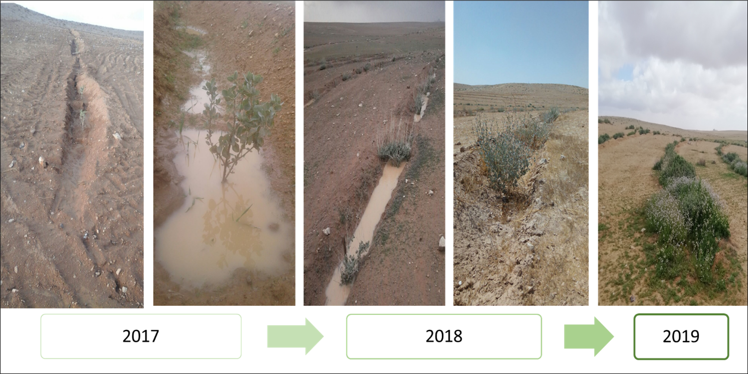
Mechanized micro water harvesting breaks up crusted and compacted soils, and fosters the capture and retention and the deep-infiltration of surface runoff generated during heavy rainfall events. The micro water harvesting pits store water and provide soil moisture to the out-planted shrub seedlings and the emerging seeds - and thus boosts the development of resilient vegetation patches towards the eventual rehabilitation of degraded rangelands.
2.2 Detailed description of the Technology
Description:
The micro water harvesting technology is part of a larger watershed rehabilitation initiative; It is the most upstream technology used in an integrated approach, including upland rehabilitation (Vallerani), gully erosion control, and revegetation (gully plugs), and downstream local barley agriculture using the ‘Marab’ technology.
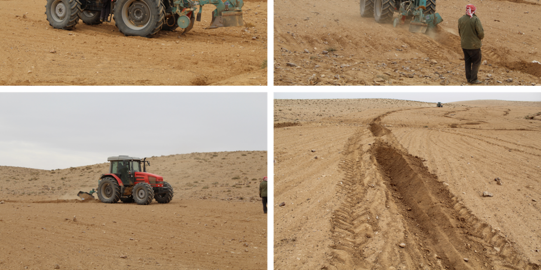
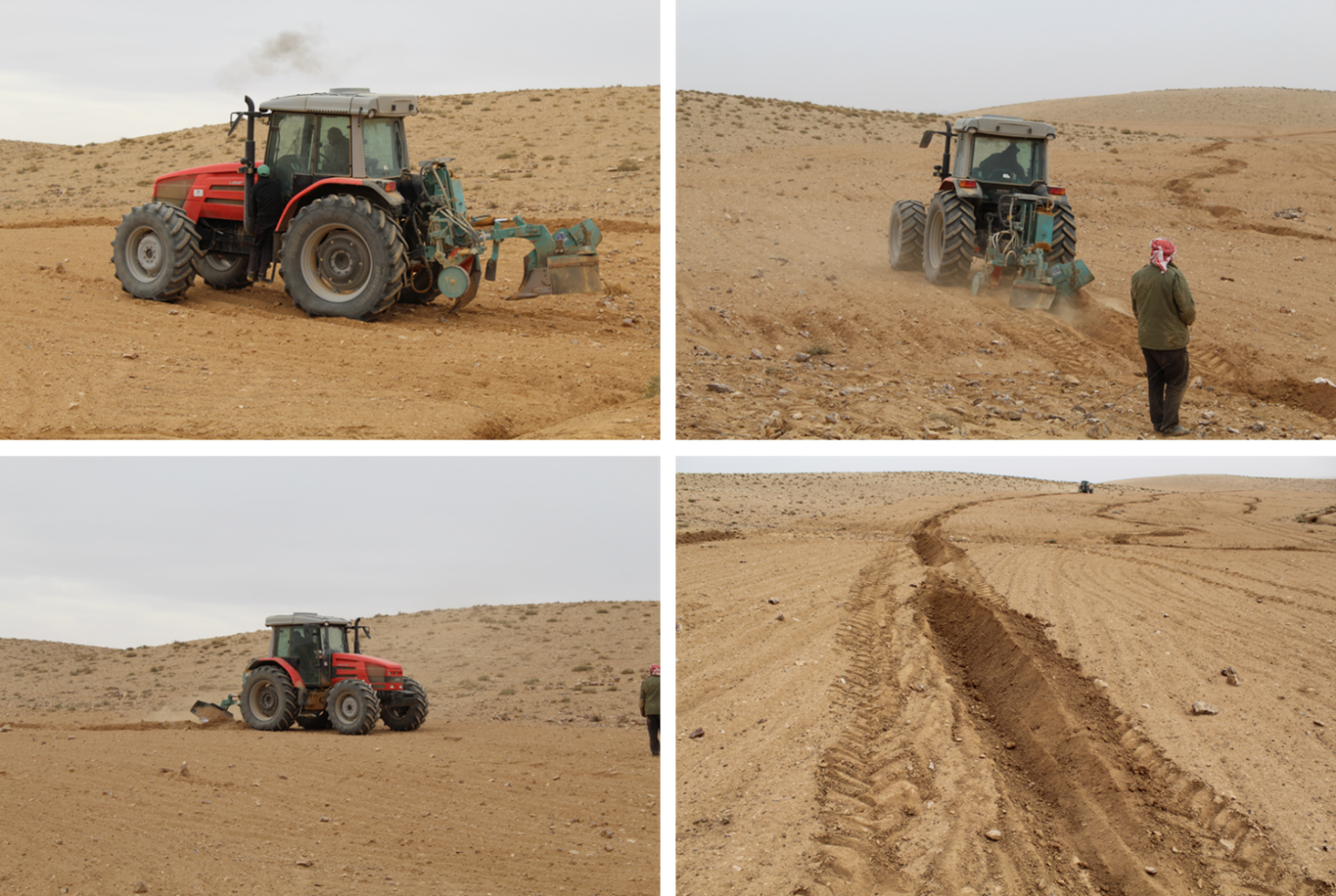
1: Main Elements: The Vallerani tractor plow (Delfino 50 MI/CM) (Gammoh & Oweis, 2011) constructs intermittent water harvesting pits along the contour of terrain and transects the hill slopes at approximately 5-10 m between lines. The local hill slope (at the implementation site) ranges between 2% and 15%. Pit length is adjustable and relates to the speed of the tractor. At the implementation site, pit lengths are around 4.5 m. In the micro water harvesting pits, several native shrub seedlings can be out-planted (at the site, 2 per pit).
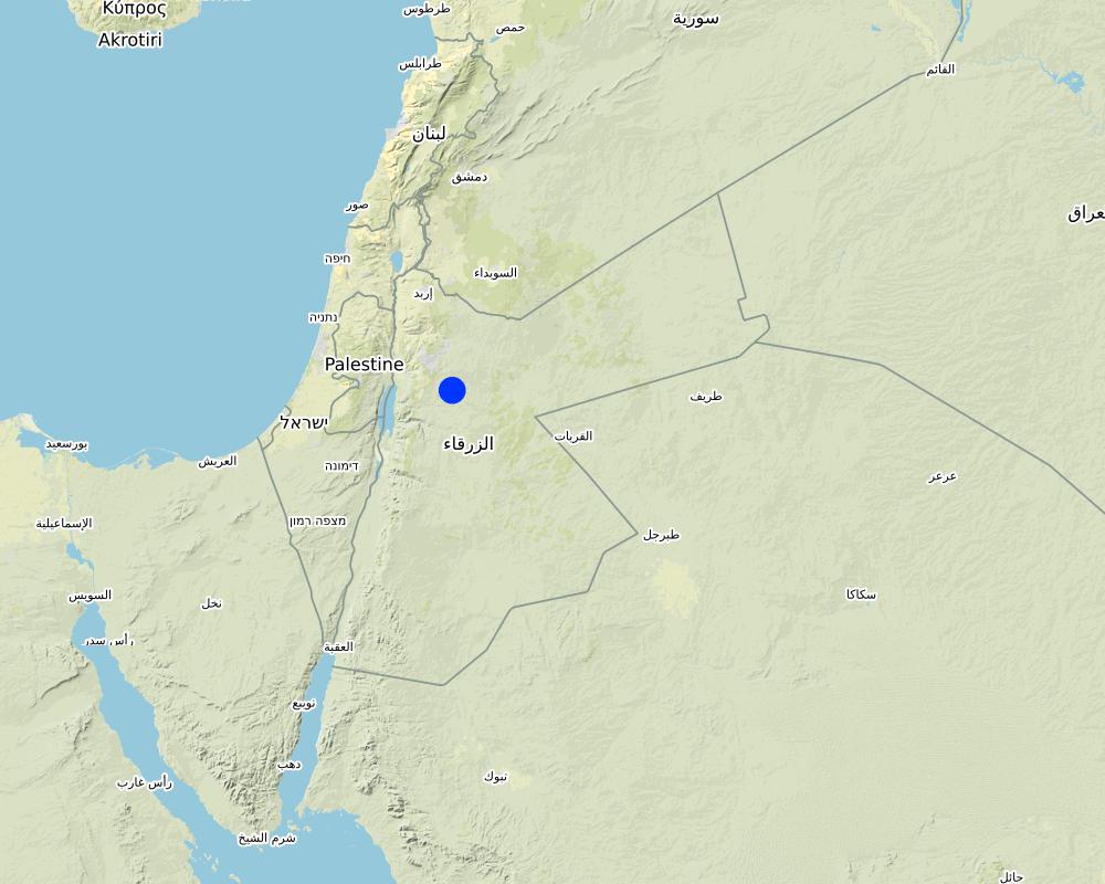
2: Where: This technology is used in a watershed context close to Al Majeddyeh village, located in the Middle Badia zone, approximately 30 km south-east of Amman. The climate is arid and warm (Palmer, 2013). The average annual rainfall is around 130 mm. The natural environment is classified as steppe, Bsh in the köppen classification. The human environment is characterized by agropastoralists. They are semi-nomadic and live in villages around the watershed, for example, Al Majeddyeh village.
3: The purpose of the technology: Breaking the land degradation cycle by retaining and encouraging deep-infiltration of surface runoff, which supports native vegetation growth. The stored soil moisture boosts the growth of both out-planted shrub seedlings and emerging local seeds towards healthy and resilient vegetation patches. Over time, the plowed pits degrade, but vegetation takes over the dryland hydrological functions of rainfall interception, runoff deceleration, and fostering infiltration. The developing shrubland provides various ecosystem services, predominately fodder for livestock of local agropastoralists.
4: Major activities: 1) Mechanized micro water harvesting establishment through the Vallerani tractor plow. 2) plantation of native seedlings in the pits (2 shrubs per pit at the local site). 3) Manage rangelands through sustainable grazing.
5: Impact: The technology breaks up the degradation cycle, increases soil moisture, and eventually boosts vegetation development and biodiversity. Through retention of runoff, sediments and residues, it decreases erosion and enhances organic carbon storage. It reduces peak surface runoff and thus mitigates flooding. The enhanced biomass supports livestock (grazing) and reduces agricultural inputs required (such as those required for low input barley production).
6: Land users' opinion: Land users evaluate the technology ambivalently. In the short term, landowners are often skeptical, because the rehabilitation requires a recovery time and strict non-grazing/resting for (usually) the first 2 rainy seasons. Thereafter, the rehabilitated lands require sustainable management. Later, after vegetation development, most landowners are convinced of the improvements and understand the economic and environmental value. The acceptance strongly depends on the social and cultural context – many farmers continue preferring the already established barley monoculture, mainly due to lack of sustainable rangeland management options and land ownership. However, well-targeted awareness campaigns can be supportive.
2.3 Photos of the Technology
Media Gallery

2.5 Country/ region/ locations where the Technology has been applied and which are covered by this assessment
Country:
Jordan
Region/ State/ Province:
Amman governorates /Al Jiza District/Al Majeddyeh Village
Further specification of location:
Al Majeddyeh Village
Specify the spread of the Technology:
- evenly spread over an area
If the Technology is evenly spread over an area, specify area covered (in km2):
30.0
Is/are the technology site(s) located in a permanently protected area?
No
Map
×2.6 Date of implementation
Indicate year of implementation:
2016
2.7 Introduction of the Technology
Specify how the Technology was introduced:
- during experiments/ research
- through projects/ external interventions
Comments (type of project, etc.):
This specific project was serving as a basis for SLM introduction and was launched in 2016.
The Vallerani Plough was locally tested in earlier projects.
The Vallerani Plough in Badia rehabilitation context was first introduced in Syria in 2004-2007.
3. Classification of the SLM Technology
3.1 Main purpose(s) of the Technology
- improve production
- reduce, prevent, restore land degradation
- conserve ecosystem
- protect a watershed/ downstream areas – in combination with other Technologies
- adapt to climate change/ extremes and its impacts
3.2 Current land use type(s) where the Technology is applied
Land use mixed within the same land unit:
No

Grazing land
Extensive grazing:
- Semi-nomadic pastoralism
Intensive grazing/ fodder production:
- Improved pastures
- Grazing Management plan
Animal type:
- goats
- sheep
Is integrated crop-livestock management practiced?
Yes
If yes, specify:
crop and livestock farming combined
- So far, the site opened for grazing after 2 years of protection in Oct.-Nov. 2018, Oct.- Nov. 2019, as well as April and Nov. 2020
Species:
goats
Count:
300
Species:
sheep
Count:
50

Other
Specify:
Restoration
Remarks:
Planting of native shrub species: Atriplex Halimus, Retama, and Salsola.
3.3 Has land use changed due to the implementation of the Technology?
Has land use changed due to the implementation of the Technology?
- No (Continue with question 3.4)
3.4 Water supply
Water supply for the land on which the Technology is applied:
- rainfed
Comments:
The technology harvests surface runoff of erratic and heavy rainstorms
3.5 SLM group to which the Technology belongs
- improved ground/ vegetation cover
- cross-slope measure
- water harvesting
3.6 SLM measures comprising the Technology

agronomic measures
- A4: Subsurface treatment
- A6: Residue management

vegetative measures
- V2: Grasses and perennial herbaceous plants
- V5: Others

structural measures
- S2: Bunds, banks
- S11: Others

management measures
- M2: Change of management/ intensity level
- M3: Layout according to natural and human environment
- M4: Major change in timing of activities
- M5: Control/ change of species composition
- M7: Others
other measures
Specify:
Specify tillage system: reduced tillage (> 30% soil cover)
Specify residue management: grazed
Comments/ remarks: Vegetation biomass is used as fodder for livestock as well as retained (for recruitment) – managed through a sustainable grazing plan. The technology consists of a combination of structural and re-vegetative measures. The structural measure provides the opportunity for vegetation development beyond the out-planted species.
Comments:
Native shrubs (fodder shrubs) planted in the water harvesting pits.
Intermittent pits constructed by the Vallerani Plough
Management (grazing) plan after implementation
3.7 Main types of land degradation addressed by the Technology

soil erosion by water
- Wt: loss of topsoil/ surface erosion
- Wg: gully erosion/ gullying
- Wo: offsite degradation effects

soil erosion by wind
- Et: loss of topsoil
- Ed: deflation and deposition
- Eo: offsite degradation effects

chemical soil deterioration
- Cn: fertility decline and reduced organic matter content (not caused by erosion)

physical soil deterioration
- Pc: compaction
- Pk: slaking and crusting

biological degradation
- Bc: reduction of vegetation cover
- Bh: loss of habitats
- Bs: quality and species composition/ diversity decline
- Bl: loss of soil life

water degradation
- Ha: aridification
- Hs: change in quantity of surface water
Comments:
Degradation is mainly caused by over-exploitation of vegetation (overgrazing), mechanized agriculture (ploughing and barley seeding) – but accelerated by climate change.
3.8 Prevention, reduction, or restoration of land degradation
Specify the goal of the Technology with regard to land degradation:
- reduce land degradation
- restore/ rehabilitate severely degraded land
4. Technical specifications, implementation activities, inputs, and costs
4.1 Technical drawing of the Technology
Technical specifications (related to technical drawing):
The dimensions of the water harvesting pits, constructed by the Vallerani tractor plow, are 4.5m, 0.5m, and 0.3m in length, width, and depth. With those dimensions, the effective water capturing total volume of one pit reaches approximately 0.2 to 0.3 m3 – depending on the formation process (e.g., depending on terrain, local soil, tractor speed). The interspace between the contours of water harvesting pits (in downslope direction) is approximately 7 meters at the implementation site. However, interspace strongly varies due to local terrain, soil, and rainfall pattern. The lateral spacing between pits is around 0.5m-1.0m.
Two local shrub seedlings of either Atriplex Halimus, Retama, or Salsola have been out-planted in the pit. These plants are native (adapted to the local environment) and drought tolerant. However, the early stage seedlings are vulnerable, and micro water harvesting substantially increases survival and fast development and allows the cumulation of top-soil, residues, and seed material.
At the specific site, micro water harvesting was established on slopes varying between 2% and 15%. The local rehabilitated area is around 10 hectares large. Around 1500 pits have been developed corresponding to 3000 planted shrub seedlings.
Author:
Sayo Fukai
Date:
01/11/2019
4.2 General information regarding the calculation of inputs and costs
Specify how costs and inputs were calculated:
- per Technology area
Indicate size and area unit:
1ha
Specify currency used for cost calculations:
- USD
4.3 Establishment activities
| Activity | Timing (season) | |
|---|---|---|
| 1. | Site Selection (biophysical suitability) | At least 1 year prior implementation |
| 2. | Site inspection & local community consultation (social assessment, awareness and planning) | Around 1 year prior implementation |
| 3. | Ploughing of micro water harvesting pits along the contour (e.g. laser guided) | Late dry season (at least 1 month prior rainy season onset) |
| 4. | Out-planting of native shrubs seedlings (e.g. Atriplex and Ratameh) – potentially community inclusive activity | After first substantial rainfall (e.g. > 5mm rainfall event) |
| 5. | Sustainable management by the local community (grazing and resting plan) | Approximately after 2 years (sustainable grazing includes certain resting – chance for seeds production and recruitment) |
4.4 Costs and inputs needed for establishment
| Specify input | Unit | Quantity | Costs per Unit | Total costs per input | % of costs borne by land users | |
|---|---|---|---|---|---|---|
| Labour | Tractor plough operation | Labour Day per hectare | 0.2 | 25.0 | 5.0 | |
| Labour | Technical assistance | LD | 0.2 | 50.0 | 10.0 | |
| Labour | Seedling planters (local community) | LD | 5.0 | 20.0 | 100.0 | |
| Equipment | Tractor + Vallerani Plough (transport & fuel) | Day | 0.2 | 200.0 | 40.0 | |
| Equipment | Field equipment | Day | 1.0 | 20.0 | 20.0 | |
| Plant material | Atriplex Halimus | Seedling | 100.0 | 0.5 | 50.0 | |
| Plant material | Retama | Seedling | 100.0 | 0.5 | 50.0 | |
| Plant material | Salsola | Seedling | 100.0 | 0.5 | 50.0 | |
| Other | Transportation and storage (e.g. seedlings) | Lumpsum per hectare | 1.0 | 20.0 | 20.0 | |
| Total costs for establishment of the Technology | 345.0 | |||||
| Total costs for establishment of the Technology in USD | 345.0 | |||||
Comments:
The shrub seedlings used were of high quality. A local community was used for labour. These two items increase costs per hectare – costs per hectare can be significantly reduced using ‘cheap’ seedlings or professional agricultural labour. However, the purpose of the project was local community inclusion and their benefit.
4.5 Maintenance/ recurrent activities
| Activity | Timing/ frequency | |
|---|---|---|
| 1. | Sustainable grazing (take half / leave half concept) | 1-2 times per season |
| 2. | Cut and carry | locally |
| 3. | Resting for shrub-seed production and new recruitment | Some selected resting seasons |
4.6 Costs and inputs needed for maintenance/ recurrent activities (per year)
Comments:
The technology aims at re-establishing a sustainable nature-based ecosystem. Once properly implemented and managed, no further maintenance is needed. Certainly, ‘costs’ during biomass facilitation accrue through, e.g., herding and watering of livestock; however, these costs are not considered to occur because of the landscape improvement.
4.7 Most important factors affecting the costs
Describe the most determinate factors affecting the costs:
The most important cost is the high-quality seedlings and the local labor costs. Both can be reduced.
5. Natural and human environment
5.1 Climate
Annual rainfall
- < 250 mm
- 251-500 mm
- 501-750 mm
- 751-1,000 mm
- 1,001-1,500 mm
- 1,501-2,000 mm
- 2,001-3,000 mm
- 3,001-4,000 mm
- > 4,000 mm
Specify average annual rainfall (if known), in mm:
130.00
Specifications/ comments on rainfall:
Jordan has a rainy season from September to May – but locally, the effective rainy season sets on later (November or December) and lasts until April.
The average annual rainfall on-site for the recent three years is approximately 130 mm.
Indicate the name of the reference meteorological station considered:
Queen Alia international airport reference station reports long term average annual rainfall of about 150 mm A rainfall tipping bucket installed in the site in 2016.
Agro-climatic zone
- arid
The maximum temperature usually occurred between July and August.
The average daily maximum temperature is 25.01 °C.
The average daily minimum temperature is 8.5 °C
5.2 Topography
Slopes on average:
- flat (0-2%)
- gentle (3-5%)
- moderate (6-10%)
- rolling (11-15%)
- hilly (16-30%)
- steep (31-60%)
- very steep (>60%)
Landforms:
- plateau/plains
- ridges
- mountain slopes
- hill slopes
- footslopes
- valley floors
Altitudinal zone:
- 0-100 m a.s.l.
- 101-500 m a.s.l.
- 501-1,000 m a.s.l.
- 1,001-1,500 m a.s.l.
- 1,501-2,000 m a.s.l.
- 2,001-2,500 m a.s.l.
- 2,501-3,000 m a.s.l.
- 3,001-4,000 m a.s.l.
- > 4,000 m a.s.l.
Indicate if the Technology is specifically applied in:
- not relevant
Comments and further specifications on topography:
Site topography ranges from 853 to 910 m above sea level (ASL), with an average slope steepness of 7.4 %.
5.3 Soils
Soil depth on average:
- very shallow (0-20 cm)
- shallow (21-50 cm)
- moderately deep (51-80 cm)
- deep (81-120 cm)
- very deep (> 120 cm)
Soil texture (topsoil):
- medium (loamy, silty)
Soil texture (> 20 cm below surface):
- medium (loamy, silty)
Topsoil organic matter:
- low (<1%)
If available, attach full soil description or specify the available information, e.g. soil type, soil PH/ acidity, Cation Exchange Capacity, nitrogen, salinity etc.
The soil texture ranges from silty clay to silty clay loam.
Soil pH ranges from 8 – 8.5.
The soil is not saline.
5.4 Water availability and quality
Ground water table:
> 50 m
Availability of surface water:
poor/ none
Water quality (untreated):
unusable
Water quality refers to:
ground water
Is water salinity a problem?
No
Is flooding of the area occurring?
Yes
Regularity:
frequently
5.5 Biodiversity
Species diversity:
- high
Habitat diversity:
- high
Comments and further specifications on biodiversity:
Atriplex, Ratameh and Salsola were actively out-planted (native species). This is not very biodiverse, but the evolving micro-habitat within the water harvesting pit allows emergence of collected seeds and consequential development of biodiverse vegetation patches
5.6 Characteristics of land users applying the Technology
Sedentary or nomadic:
- Sedentary
- Semi-nomadic
Market orientation of production system:
- mixed (subsistence/ commercial)
Off-farm income:
- less than 10% of all income
Relative level of wealth:
- poor
- average
Individuals or groups:
- individual/ household
Level of mechanization:
- mechanized/ motorized
Gender:
- men
Age of land users:
- youth
- middle-aged
Indicate other relevant characteristics of the land users:
The actual landowners and users are often poor Jordanians. However, the owners of the large livestock flocks (potential facilitators of the rehabilitated lands) are comparatively rich.
5.7 Average area of land used by land users applying the Technology
- < 0.5 ha
- 0.5-1 ha
- 1-2 ha
- 2-5 ha
- 5-15 ha
- 15-50 ha
- 50-100 ha
- 100-500 ha
- 500-1,000 ha
- 1,000-10,000 ha
- > 10,000 ha
Is this considered small-, medium- or large-scale (referring to local context)?
- medium-scale
5.8 Land ownership, land use rights, and water use rights
Land ownership:
- individual, titled
Land use rights:
- individual
- NA
Are land use rights based on a traditional legal system?
Yes
5.9 Access to services and infrastructure
health:
- poor
- moderate
- good
education:
- poor
- moderate
- good
technical assistance:
- poor
- moderate
- good
employment (e.g. off-farm):
- poor
- moderate
- good
markets:
- poor
- moderate
- good
energy:
- poor
- moderate
- good
roads and transport:
- poor
- moderate
- good
drinking water and sanitation:
- poor
- moderate
- good
financial services:
- poor
- moderate
- good
6. Impacts and concluding statements
6.1 On-site impacts the Technology has shown
Socio-economic impacts
Production
fodder production
fodder quality
animal production
product diversity
land management
Income and costs
expenses on agricultural inputs
workload
Socio-cultural impacts
food security/ self-sufficiency
recreational opportunities
SLM/ land degradation knowledge
Ecological impacts
Water cycle/ runoff
water quantity
harvesting/ collection of water
surface runoff
evaporation
Soil
soil moisture
soil cover
soil loss
soil accumulation
soil crusting/ sealing
soil organic matter/ below ground C
Biodiversity: vegetation, animals
Vegetation cover
biomass/ above ground C
plant diversity
invasive alien species
habitat diversity
Climate and disaster risk reduction
flood impacts
impacts of cyclones, rain storms
micro-climate
6.2 Off-site impacts the Technology has shown
reliable and stable stream flows in dry season
downstream flooding
downstream siltation
wind transported sediments
6.3 Exposure and sensitivity of the Technology to gradual climate change and climate-related extremes/ disasters (as perceived by land users)
Gradual climate change
Gradual climate change
| Season | increase or decrease | How does the Technology cope with it? | |
|---|---|---|---|
| annual temperature | increase | very well | |
| annual rainfall | decrease | very well |
Climate-related extremes (disasters)
Meteorological disasters
| How does the Technology cope with it? | |
|---|---|
| local rainstorm | very well |
Climatological disasters
| How does the Technology cope with it? | |
|---|---|
| extreme winter conditions | very well |
Hydrological disasters
| How does the Technology cope with it? | |
|---|---|
| flash flood | very well |
6.4 Cost-benefit analysis
How do the benefits compare with the establishment costs (from land users’ perspective)?
Short-term returns:
slightly negative
Long-term returns:
positive
How do the benefits compare with the maintenance/ recurrent costs (from land users' perspective)?
Short-term returns:
very positive
Long-term returns:
very positive
6.5 Adoption of the Technology
- 1-10%
Of all those who have adopted the Technology, how many did so spontaneously, i.e. without receiving any material incentives/ payments?
- 11-50%
6.6 Adaptation
Has the Technology been modified recently to adapt to changing conditions?
Yes
other (specify):
watershed approach and transition status of the structures
Specify adaptation of the Technology (design, material/ species, etc.):
Implementation efficiency increase through adding contour laser technique and using the reversible blade (2 directions plowing)
6.7 Strengths/ advantages/ opportunities of the Technology
| Strengths/ advantages/ opportunities in the land user’s view |
|---|
| Opportunity for agro-pastoralism (grazing up to twice a year) |
| Improved livestock health, milk quantity, and quality. |
| No input costs needed (compared with e.g. barley agriculture) |
| Flexibility in timing: grazing of healthy rangelands can be done ‘at any time’(certainly spring season is most beneficial for livestock) – which differs from barley agriculture approach. |
| Strengths/ advantages/ opportunities in the compiler’s or other key resource person’s view |
|---|
| Besides out-planting of native shrub seedlings, native biodiversity evolves through the emergence of dormant seed material. |
| Out-planted shrub seedlings withstand extreme weather conditions (droughts) through water harvesting. The survival rate and eventual success of the rehabilitation approach are high. |
| Micro water harvesting structures and upcoming vegetation patches reduce erosion and increase trapping of sediments, including organic carbon and seed materials. |
| Water harvesting reduces the peak of surface runoff and thus mitigates downstream flooding |
6.8 Weaknesses/ disadvantages/ risks of the Technology and ways of overcoming them
| Weaknesses/ disadvantages/ risks in the land user’s view | How can they be overcome? |
|---|---|
| Costs of implementation and availability of high-quality seedlings and the Vallerani plow. | Develop large-scale procedure/initiative that allows farmers to request and restore vulnerable areas using the Vallerani micro-water harvesting technique. Include incentives for implementation (ex. free seedlings, free of charge using of Vallerani machine, subsidies on arley as fodder for the first two years in order for farmers to maintain the site) |
| Change: Not all farmers are willing to forgo barley agriculture | Demonstrating the effects this technology through pilot projects. Local communities on the forefront of communication. |
| Vegetation growth may attract herders from different areas. | Clear rules and legislation on land facilitation in terms of grazing. |
| Requires higher understanding of the environment and long-term planning | Introduce knowledge sharing events to teach local farmers on the effects of land degradation and the benefits of healthy ecosystems |
| Weaknesses/ disadvantages/ risks in the compiler’s or other key resource person’s view | How can they be overcome? |
|---|---|
| Land ownership: current land tenure system in Jordan slows the adoption of the intervention. A landowner can reside in a city (no much value for the land), and the land user may be a herder. A large flock owner can rent huge areas for barley cultivation (actual cost of 1 donum of barley plantation ranges between 1.5-3 USD; possible to prepare up to 10 ha per day). Cheap labor/herders will move flocks and graze until all cover is gone (usually for 1-3 months maximum per year (March-May)). Rehabilitated areas will be of less interest for such users. | Develop and apply strict land management plans and policies. Create a strong monitoring system. Apply penalties for actions that increase land degradation with various on-site and off-sites impacts |
| Lack of institutional collaboration for rangeland management and rehabilitation. Land management in the Badia is the responsibility of several ministries in Jordan. The lack of institutional collaboration and the absence of the rangeland areas' valuation create a difficult environment for sustainability measures. | Increase the collaboration between ministries and stakeholders. Evaluate the impact of restoration solutions on the site and off site. |
| Lack of clear government policy for restoration, incentives for farmers, and funding availability. | Develop a clear action plan among the responsible government institutions of restoration activities. |
| Complex social context. The majority of land users and/or landowners don’t value the restoration. The bare cultivation practices have more (quick) value without resting time. | Capacity development for local communities for the value of soil, water, and biodiversity |
7. References and links
7.1 Methods/ sources of information
- field visits, field surveys
15
- interviews with land users
2
- interviews with SLM specialists/ experts
4
- compilation from reports and other existing documentation
When were the data compiled (in the field)?
15/02/2020
7.2 References to available publications
Title, author, year, ISBN:
Akroush, S., & All, E. (2016). Factors Affecting the Adoption of Water Harvesting Technologies: A Case Study of Jordanian Arid Area. Sustainable Agriculture Research.
Title, author, year, ISBN:
Akroush, S., & Boubaker, D. (2015). Predicted Willingness of Farmers to Adopt Water Harvesting Technologies: A Case Study from the Jordanian Badia (Jordan). American-Eurasian J. Agricultural & Environmental science , 1502-1513.
Title, author, year, ISBN:
Gammoh, & Oweis. (2011). Performance and Adaptation of the Vallerani Mechanized Water Harvesting System in Degraded Badia Rangelands . Journal of Environmental Science and Engineering, 1370-1380.
Title, author, year, ISBN:
Haddad, M. (2019). Exploring Jordan's Rangeland Transition: Merging Restoration Eperiment with Modeling - A Case study from Al Majdiyya Village. Amman: The University of Jordan.
Title, author, year, ISBN:
Vallerani. (n.d.). Vallerani system. Retrieved from Vallerani: http://www.vallerani.com/wp/
7.3 Links to relevant online information
Title/ description:
VALLERANI MICRO WATER HARVESTING
URL:
https://www.icarda.org/impact/impact-stories/vallerani-micro-water-harvesting
Title/ description:
CONTOUR LASER GUIDING FOR THE MECHANIZED “VALLERANI” MICRO-CATCHMENT WATER HARVESTING SYSTEMS
URL:
https://www.icarda.org/publications/10291/contour-laser-guiding-mechanized-vallerani-micro-catchment-water-harvesting
7.4 General comments
The Marab is a local downstream water harvesting measure in an integrated watershed context, where up/midstream users and applied land management practices affect the Marab.
The technology diverts and spreads excess runoff over deep-soil flood plains. The technology comprises local gully-filling, grading/leveling of seedbed, and construction of a bund-and-spillway system creating several compartments for flood-irrigated agriculture.
For more information please visit: https://qcat.wocat.net/en/wocat/technologies/view/technologies_5770/
Links and modules
Expand all Collapse allLinks
No links
Modules
No modules