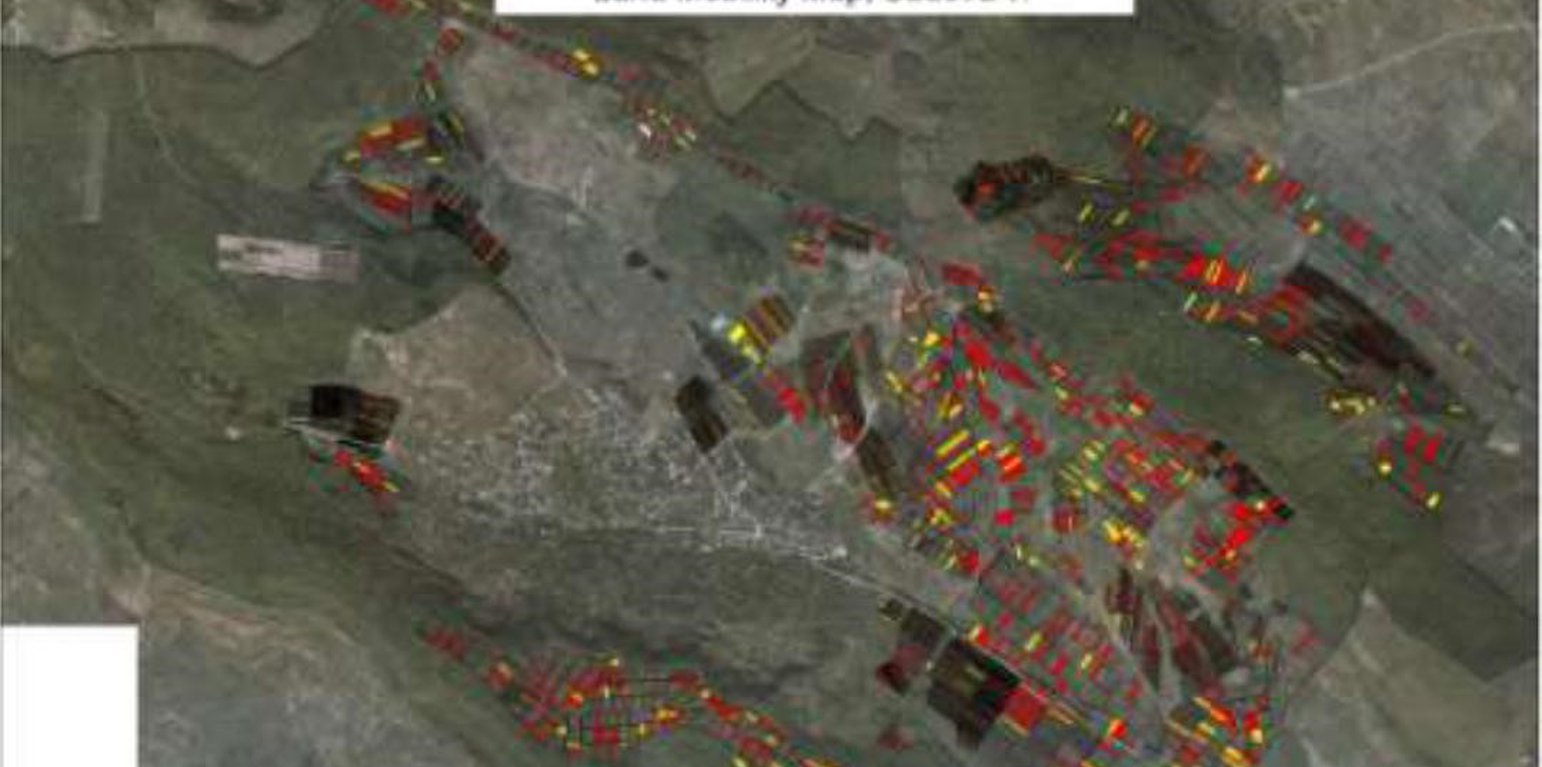
Land mobility map (Morten Hartvigsen)

Environmentally-Friendly Community Practices (摩尔多瓦共和国)

Practicile comunitare prietenoase mediului

描述

Community area development plans were developed taking into consideration the main problems, opportunities, necessities and wishes of the local population. All communities included afforestation of severely eroded land, re-establishing degraded forest belts and planting new forest lines, creating protection shields for aquatic areas, and an ecological education community program.

Community area development plans were developed for six communities for the period of 2008-2028, taking into consideration the main problems, opportunities, requirements and wishes of the local population. Special attention was paid to environmental impact assessment to harmonize economic and social development with environmental protection. All communities included afforestation of severely eroded land, re-establishing degraded forest belts and planting new forest lines, creating protection shields for aquatic areas, and elaborating and implementing a ecological education community program.
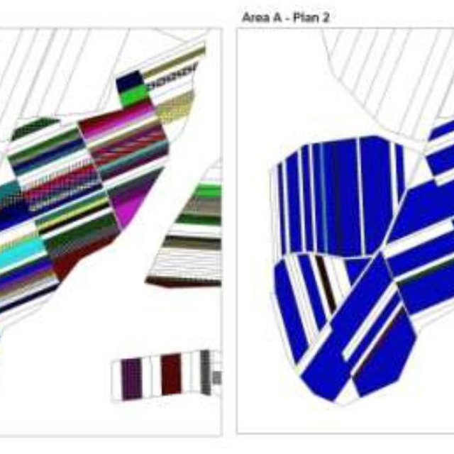
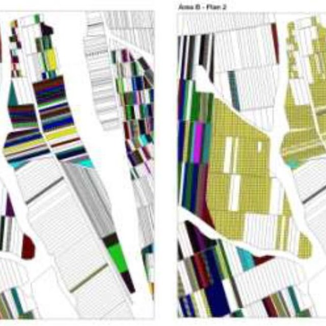
The first action implemented was agricultural land re-parcelling, based on FAO guidelines. Training programs were conducted for project staff and beneficiaries. Following land planning, discussions and individual negotiations with each land owner, the project promoted the application of the following land parcels operations: sale, exchange and long term lease. The costs incurred during land transactions were fully covered by the project. The Land Use Scheme implies changes in some categories of use and especially expanding the area of vineyards and orchards as well as using agricultural land for community development according to the needs and wishes of the population. Land re-parcelling offers farmers the possibility of rearranging agricultural land according to ecological principles and potential.
The overall goal of land re-parcelling component was to respond to the concerns of the Government and others about the fragmentation of agricultural land: it focussed on small peasant farms as its primary target group. The specific objectives of the pilot action were:
- to test the demand for and feasibility of land re-parcelling with small landowners as the primary target group;
- to facilitate development of 6 community area development plans, taking into account environmental impact assessment.
- to use the pilot experience as the basis for designing a potential national-level approach, including techniques, resource requirements and legislative framework;
- to assess the impact of re-parcelling at the local level, including on land markets, agricultural production, and equity.

The re-parcelling activities were extended to 40 villages on the proviso that the concept and the experience of the implemented re-parcelling pilots would be precisely followed. Based on this experience, the Ministry of Agriculture is in active partnership with National Agency for Rural Development and NGO BIOS, supported by the FAO-developed National Strategy for Land Consolidation.

地点

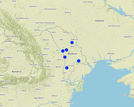
地点: The six communes which form the pilot area, namely Basauca village Rezina district, Sadova village Calarasi district, Calmatui village Hincesti district, Bolduresti community of Cantemir district, Baimaclia community Cantemir district, Opaci village Causeni district, Republic of Moldova. The experience was replicated in 40 villages., 摩尔多瓦共和国

分析的技术场所数量: 2-10个场所

选定地点的地理参考
  • 29.34036, 46.56783
  • 28.37082, 46.16889
  • 28.21838, 46.77773
  • 28.35091, 47.18528
  • 28.04672, 47.12551
  • 28.7974, 47.58972

技术传播: 均匀地分布在一个区域 (approx. > 10,000 平方千米)

实施日期: 不到10年前(最近)

介绍类型
Land ownership in part of Bolduresti – before and after the project (first example) (Morten Hartvigsen)
Land ownership in part of Bolduresti – before and after the project (second example) (Morten Hartvigsen)

技术分类

主要目的
  • 改良生产
  • 减少、预防、恢复土地退化
  • 保护生态系统
  • 结合其他技术保护流域/下游区域
  • 保持/提高生物多样性
  • 降低灾害风险
  • 适应气候变化/极端天气及其影响
  • 减缓气候变化及其影响
  • 创造有益的经济影响
  • 创造有益的社会影响
土地利用

  • 农田 - 一年一作, 多年一作(非木材)
  • 其它 - 具体说明: - Land fragmentation; - Environmentally unsustainable land management practices; - Illegal cutting of forests, leading to the destruction of forest belts and buffer strips; - Point and non-point sources of pollution, - Over-grazing..

供水
  • 雨养
  • 混合雨水灌溉
  • 充分灌溉

每年的生长季节数: 1
该技术实施前的土地利用: 不适用
牲畜密度: 不适用

土地退化相关的目的
  • 防止土地退化
  • 减少土地退化
  • 修复/恢复严重退化的土地
  • 适应土地退化
  • 不适用
解决的退化问题
  • 土壤水蚀 - Wt:表土流失/地表侵蚀 , Wr:河岸侵蚀, Wo:场外劣化效应
  • 土壤风蚀 - Et:表土流失, Ed:风蚀风积
  • 物理性土壤退化 - Pc:压实, Pu:由于其他活动而导致生物生产功能的丧失
  • 生物性退化 - Bc:植被覆盖的减少, Bh:栖息地丧失, Bq:数量/生物量减少, Bs:质量和物种组成/多样性的下降, Bl:土壤寿命损失
SLM组
  • 轮作制度(轮作、休耕、轮垦)
  • 农畜综合管理
  • 横坡措施
SLM措施
  • 农艺措施 - A1:植被和土壤覆盖层, A2:有机质/土壤肥力
  • 植物措施 - V1:乔木和灌木覆盖层, V2:草和多年生草本植物
  • 结构措施 - S5:大坝、集水斗、水池, S6:墙、障碍物、栅栏、围墙, S9:动植物庇护所
  • 管理措施 - M1:改变土地使用类型, M2:改变管理/强度级别

技术图纸

技术规范

技术建立与维护:活动、投入和费用

投入和成本的计算
  • 计算的成本为:
  • 成本计算使用的货币:不适用
  • 汇率(换算为美元):1 美元 = 不适用
  • 雇用劳工的每日平均工资成本:不适用
影响成本的最重要因素
不适用
技术建立活动
  1. Implementing activities of protection, maintenance and improving of degraded soil fertility (时间/频率: None)
  2. Agroforestry consisting of planting of tree rows on cultivated lands, primarily of windbreaks and anti-erosion protective belts. (时间/频率: None)
  3. Improving the quality of pastures and implementing controlled pasturing| (时间/频率: None)
  4. Regeneration of degraded commune forest as well as existing forest protective belts (时间/频率: None)
  5. Planting of tree rows on cultivated lands, primarily of windbreaks and anti-erosion protective belts (时间/频率: None)
技术维护活动
n.a.

自然环境

年平均降雨量
  • < 250毫米
  • 251-500毫米
  • 501-750毫米
  • 751-1,000毫米
  • 1,001-1,500毫米
  • 1,501-2,000毫米
  • 2,001-3,000毫米
  • 3,001-4,000毫米
  • > 4,000毫米
农业气候带
  • 潮湿的
  • 半湿润
  • 半干旱
  • 干旱
关于气候的规范
气象站名称:Chisinau, Nisporeni, Calarasi, Cahul, Leova, Hincesti, Rezina
Moldova's climate is moderately continental: the summers are warm and long, with temperatures averaging 20 °C, and the winters are relatively mild and dry, with January temperatures averaging −4 °C. Annual rainfall, which ranges from around 600 millimeters in the north to 400 millimeters in the south, can vary greatly. The heaviest rainfall occurs in summer; heavy showers and thunderstorms are common. Because of the irregular terrain, heavy summer rains often cause erosion and river silting.|
斜坡
  • 水平(0-2%)
  • 缓降(3-5%)
  • 平缓(6-10%)
  • 滚坡(11-15%)
  • 崎岖(16-30%)
  • 陡峭(31-60%)
  • 非常陡峭(>60%)
地形
  • 高原/平原
  • 山脊
  • 山坡
  • 山地斜坡
  • 麓坡
  • 谷底
海拔
  • 0-100 m a.s.l.
  • 101-500 m a.s.l.
  • 501-1,000 m a.s.l.
  • 1,001-1,500 m a.s.l.
  • 1,501-2,000 m a.s.l.
  • 2,001-2,500 m a.s.l.
  • 2,501-3,000 m a.s.l.
  • 3,001-4,000 m a.s.l.
  • > 4,000 m a.s.l.
......应用的技术
  • 凸形情况
  • 凹陷情况
  • 不相关
土壤深度
  • 非常浅(0-20厘米)
  • 浅(21-50厘米)
  • 中等深度(51-80厘米)
  • 深(81-120厘米)
  • 非常深(> 120厘米)
土壤质地(表土)
  • 粗粒/轻(砂质)
  • 中粒(壤土、粉土)
  • 细粒/重质(粘土)
土壤质地(地表以下>20厘米)
  • 粗粒/轻(砂质)
  • 中粒(壤土、粉土)
  • 细粒/重质(粘土)
表土有机质含量
  • 高(>3%)
  • 中(1-3%)
  • 低(<1%)
地下水位
  • 表面上
  • < 5米
  • 5-50米
  • > 50米
地表水的可用性
  • 过量
  • 中等
  • 匮乏/没有
水质(未处理)
  • 良好饮用水
  • 不良饮用水(需要处理)
  • 仅供农业使用(灌溉)
  • 不可用
盐度是个问题吗?

洪水发生
物种多样性
  • 中等
栖息地多样性
  • 中等

应用该技术的土地使用者的特征

市场定位
  • 生计(自给)
  • 混合(生计/商业
  • 商业/市场
非农收入
  • 低于全部收入的10%
  • 收入的10-50%
  • > 收入的50%
相对财富水平
  • 非常贫瘠
  • 贫瘠
  • 平均水平
  • 丰富
  • 非常丰富
机械化水平
  • 手工作业
  • 畜力牵引
  • 机械化/电动
定栖或游牧
  • 定栖的
  • 半游牧的
  • 游牧的
个人或集体
  • 个人/家庭
  • 团体/社区
  • 合作社
  • 员工(公司、政府)
性别
  • 女人
  • 男人
年龄
  • 儿童
  • 青年人
  • 中年人
  • 老年人
每户使用面积
  • < 0.5 公顷
  • 0.5-1 公顷
  • 1-2 公顷
  • 2-5公顷
  • 5-15公顷
  • 15-50公顷
  • 50-100公顷
  • 100-500公顷
  • 500-1,000公顷
  • 1,000-10,000公顷
  • > 10,000公顷
规模
  • 小规模的
  • 中等规模的
  • 大规模的
土地所有权
  • 公司
  • 社区/村庄
  • 团体
  • 个人,未命名
  • 个人,有命名
土地使用权
  • 自由进入(无组织)
  • 社区(有组织)
  • 租赁
  • 个人
用水权
  • 自由进入(无组织)
  • 社区(有组织)
  • 租赁
  • 个人
进入服务和基础设施的通道
健康

贫瘠
教育

贫瘠
技术援助

贫瘠
就业(例如非农)

贫瘠
市场

贫瘠
能源

贫瘠
道路和交通

贫瘠
饮用水和卫生设施

贫瘠
金融服务

贫瘠

影响

社会经济影响
作物生产
降低
增加

畜牧生产
降低
增加

森林/林地质量
降低
增加

产品多样性
降低
增加

生产区域(耕种/使用中的新土地)
降低
增加

土地管理
妨碍
简化

饮用水的可用性
降低
增加

饮用水的质量
降低
增加

家畜用水的可用性
降低
增加

农业收入
降低
增加

收入来源的多样性
降低
增加

社会文化影响
生态影响
水的回收/收集(径流、露水、雪等)
减少
改良

地表径流
增加
降低

土壤水分
降低
增加

土壤覆盖层
减少
改良

土壤流失
增加
降低

土壤结壳/密封
增加
减少

土壤压实
增加
减少

土壤有机物/地下C
降低
增加

植被覆盖层
降低
增加

生物量/地上C
降低
增加

植物多样性
降低
增加

动物多样性
降低
增加

栖息地多样性
降低
增加

场外影响
下游洪水(不希望)
增加
减少

下游淤积
增加
降低

地下水/河流污染
增加
减少

缓冲/过滤能力(按土壤、植被、湿地划分)
减少
改良

对邻近农田的破坏
增加
减少

成本效益分析

与技术建立成本相比的效益
短期回报
非常消极
非常积极

长期回报
非常消极
非常积极

与技术维护成本相比的效益
短期回报
非常消极
非常积极

长期回报
非常消极
非常积极

气候变化

-

采用和适应

采用该技术的地区内土地使用者的百分比
  • 单例/实验
  • 1-10%
  • 10-50%
  • 大于 50%
在所有采用这种技术的人当中,有多少人在没有获得物质奖励的情况下采用了这种技术?
  • 0-10%
  • 10-50%
  • 50-90%
  • 90-100%
最近是否对该技术进行了修改以适应不断变化的条件?
什么样的变化条件?
  • 气候变化/极端气候
  • 不断变化的市场
  • 劳动力可用性(例如,由于迁移)

结论和吸取的教训

长处: 土地使用者的观点
长处: 编制者或其他关键资源人员的观点
  • Business opportunities related to community development, etc. |
    Highly motivated local governments
    Highly motivated farmers
弱点/缺点/风险: 土地使用者的观点如何克服
弱点/缺点/风险: 编制者或其他关键资源人员的观点如何克服

参考文献

编制者
  • Valentin Ciubotaru
Editors
  • Valentin Ciubotaru
  • UNCCD PRAIS
审查者
  • Farrukh Nazarmavloev
  • William Critchley
  • Rima Mekdaschi Studer
实施日期: Feb. 6, 2017
上次更新: Feb. 16, 2021
资源人
WOCAT数据库中的完整描述
链接的SLM数据
文件编制者
机构 项目
链接到网络上可用的相关信息
This work is licensed under Creative Commons Attribution-NonCommercial-ShareaAlike 4.0 International