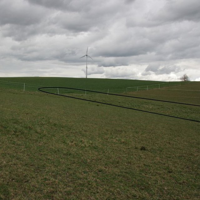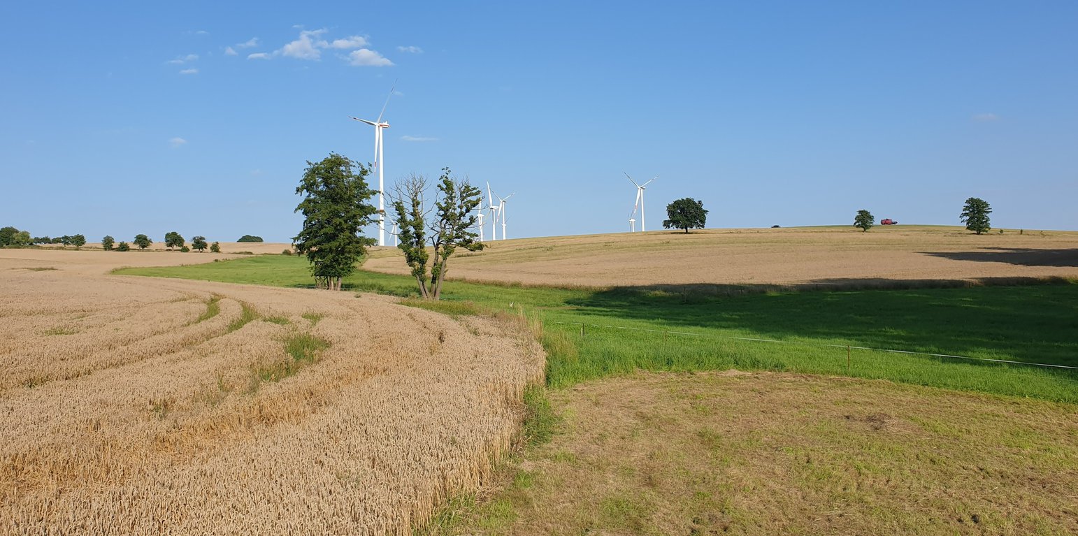
Example of a "grassed waterway" in the catchment area. (Felix Witing)

Grassed waterways (德国)

Dauerbegrünung erosionsgefährdeter Abflussbahnen

描述

A grassed waterway is a strip of grass and other permanent low growing vegetation that is established along in the main drainage line (the thalweg) of an agricultural field to discharge water safely and prevent gully development.

In order to prevent gully erosion along main drainage lines (thalwegs), grassed waterways, composed of grass and other permanent low growing vegetation, are established to discharge water safely. The grassed waterway slows down the surface runoff in the thalweg, increases infiltration and stabilizes the soil surface. This reduces soil erosion by water and the associated runoff of nutrients and pesticides. Fiener et al. (2005) reported a sediment retention of 80-95% and a water retention of 70-90%. Sediment is trapped mainly by water infiltration (infiltration-induced sedimentation) rather than by the filtering effect of vegetation. The conservation value of grassed waterways is not as high as for other measures, but they are still considered as a biotope network as well as a habitat for grassland breeders when extensive management practices are used (LfULG, 2010).
Grassed waterways are typically installed in relatively large arable fields. Normally only the most vulnerable lowest area of the field needs to be grassed. The width of the area to be grassed depends on the size of the drained catchment, the physiographic characteristics of the discharge pathway (channel shape, bottom slope) and the land management (e.g. working width of the agricultural machinery). The United States Department of Agriculture (2020) recommends a total width of the grassed waterway of about 6 m in the upper part and 15 m in the lower part. On average, a grassed waterway should occupy 2% of the catchment area (LfULG, 2015).
During the establishment of the vegetation, it is recommended to protect and stabilize the young plants against strong water flows, by temporary measures such as silt fences or mulching. Once the vegetation is dense enough to withstand heavy rain events, these temporary measures should be removed. After each heavy rainfall event, the waterway should be inspected for damage. Damaged areas should be filled and reseeded, and sediment deposits should be removed.
The choice of the seed mixture depends on the intended use and maintenance of the grassed waterway. A combination of trees and grass increases infiltration rates and natural values. Mowing should be done at least once a year, otherwise, shrubs will establish and suppress the grass. The grassed waterway should not be used as a track for vehicles because of soil compaction, and damage to vegetation. Where possible, tillage should be across the slope – therefore perpendicular to the grassed waterway in order to avoid furrows developing parallel to the waterway. A combination with conservation tillage or other erosion control practices is highly recommended (LfULG, 2010).
Grassed waterways involve a permanent change in land-use, which means a loss of cultivable area, and associated loss of yield - and of income too if it is not covered by subsidies. Many land users dislike such structures in their fields as they impede machinery. Because land users are not always the landowners, they are not always allowed to make permanent changes in land-use. In Germany, a grassland becomes permanent after 5 years. Thus, many farmers decide to plough and replant such grassed areas every 5 years.

The landowner in our documentation had suffered from lodging of his oat crop along the drainage path due to heavy rainfall. Thus, he decided to undesow the oats with ryegrass. In the following year, the undersown ryegrass developed better than the oats and the farmer decided to establish ryegrass as the main crop over the whole field – rather then just in the thalweg, to avoid having to drive around it. Now he mows the area once in the spring for silage and then uses it as pasture for his horses. Every five years, he has to plough the whole area and replant it with ryegrass to prevent it from becoming permanent grassland.
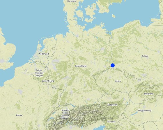
地点

地点: Saxony, 德国

分析的技术场所数量: 单一场所

选定地点的地理参考
  • 14.7792, 51.14017

技术传播: 适用于特定场所/集中在较小区域

在永久保护区?:

实施日期: 2022; 不到10年前(最近)

介绍类型
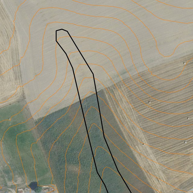
Runoff path designated by the LfULG as being particularly at risk of erosion (Data set: Map of runoff pathways that are at particular risk of erosion (vector data; Görlitz district; LfULG Saxony))
Detailed: plotted potential grassed waterway on the field (Michael Strauch)

技术分类

主要目的
  • 改良生产
  • 减少、预防、恢复土地退化
  • 保护生态系统
  • 结合其他技术保护流域/下游区域
  • 保持/提高生物多样性
  • 降低灾害风险
  • 适应气候变化/极端天气及其影响
  • 减缓气候变化及其影响
  • 创造有益的经济影响
  • 创造有益的社会影响
土地利用
同一土地单元内混合使用的土地: 是 - 农牧业(包括农牧结合)

  • 农田
    • 一年一作: 饲料作物 - 草, german rye grass
    每年的生长季节数: 1
    采用间作制度了吗?: 否
    采用轮作制度了吗?: 否
  • 牧场
    • 改良牧场
    动物类型: 马
    是否实行作物与牲畜的综合管理?: 是
    产品和服务: manure as fertilizer/ energy production
      品种计数
      2
    供水
    • 雨养
    • 混合雨水灌溉
    • 充分灌溉

    土地退化相关的目的
    • 防止土地退化
    • 减少土地退化
    • 修复/恢复严重退化的土地
    • 适应土地退化
    • 不适用
    解决的退化问题
    • 土壤水蚀 - Wt:表土流失/地表侵蚀 , Wg:冲沟侵蚀/沟蚀
    • 土壤风蚀 - Et:表土流失
    • 化学性土壤退化 - Cn:肥力下降和有机质含量下降(非侵蚀所致)
    • 物理性土壤退化 - Pc:压实, Pk:熟化和结壳
    • 生物性退化 - Bc:植被覆盖的减少, Bh:栖息地丧失, Bl:土壤寿命损失
    • 水质恶化 - Hs:地表水良变化
    SLM组
    • 改良的地面/植被覆盖
    • 引水和排水
    SLM措施
    • 植物措施 - V2:草和多年生草本植物

    技术图纸

    技术规范
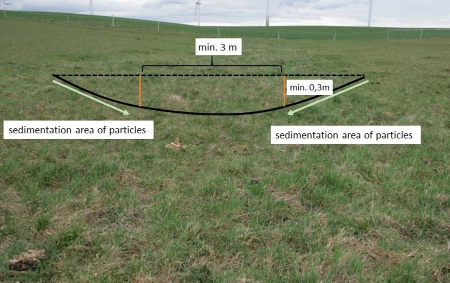
    Normally, only the vulnerable lowest area of an agricultural field ( channel shape, bottom slope) needs to be grassed. LfULG recommends 1-4 m wide side slopes with a passable gradient of 1:10 (10%) and a total width of the upper slope of about 6 m and 15 m for the lower slope. The bottom of the drainage channel must be at least 3 m wide and 0.3 m deep. The side slopes are responsible for sedimentation of particles and the bottom for infiltration of water.
    Author: Mona Pauer based on LfULG 2010, p.27
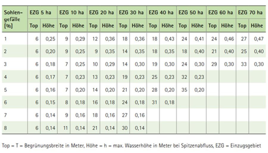
    Guide values for the width (Top) of drainage channels depending on the size of the catchment area (EZG), the slope of the riverbed (Sohlengefälle) and the height (Höhe) of the drainage channel.
    Author: LfULG 2015, p. 7

    技术建立与维护:活动、投入和费用

    投入和成本的计算
    • 计算的成本为:每个技术区域 (尺寸和面积单位:1 ha
    • 成本计算使用的货币:
    • 汇率(换算为美元):1 美元 = 0.91 €
    • 雇用劳工的每日平均工资成本:18.70 € per hour
    影响成本的最重要因素
    Landowners complained that the additional yield (grass as fodder) would have no impact on their income. The loss of income due to the loss of arable land is greater and should be compensated by subsidy programs.
    技术建立活动
    1. reseeding of ryegrass (drill seed) (时间/频率: spring)
    2. rolling (soil contact between plant and soil) (时间/频率: spring)
    技术建立的投入和成本 (per 1 ha)
    对投入进行具体说明 单位 数量 单位成本 (€) 每项投入的总成本 (€) 土地使用者承担的成本%
    劳动力
    seeding ha 1.0 20.19 20.19 100.0
    rolling ha 1.0 19.58 19.58 100.0
    植物材料
    seeds ha 1.0 32.4 32.4 100.0
    技术建立所需总成本 72.17
    技术建立总成本,美元 79.31
    技术维护活动
    1. mulching (时间/频率: every spring)
    2. ploughing (时间/频率: every 5 years)
    3. reseeding (时间/频率: every 5 years)
    技术维护的投入和成本 (per 1 ha)
    对投入进行具体说明 单位 数量 单位成本 (€) 每项投入的总成本 (€) 土地使用者承担的成本%
    劳动力
    mulching ha 1.0 24.87 24.87 100.0
    ploughing ha 0.2 63.56 12.71 100.0
    reseeding ha 0.2 39.77 7.95 100.0
    植物材料
    seeds 32,4 0.2 32.4 6.48 100.0
    技术维护所需总成本 52.01
    技术维护总成本,美元 57.15

    自然环境

    年平均降雨量
    • < 250毫米
    • 251-500毫米
    • 501-750毫米
    • 751-1,000毫米
    • 1,001-1,500毫米
    • 1,501-2,000毫米
    • 2,001-3,000毫米
    • 3,001-4,000毫米
    • > 4,000毫米
    农业气候带
    • 潮湿的
    • 半湿润
    • 半干旱
    • 干旱
    关于气候的规范
    以毫米为单位计算的年平均降雨量:775.0
    气象站名称:https://whh-kliwes.de/mapview
    LGP: 209 days (https://www.umwelt.sachsen.de/dauer-der-vegetationsperiode-30631.html)
    斜坡
    • 水平(0-2%)
    • 缓降(3-5%)
    • 平缓(6-10%)
    • 滚坡(11-15%)
    • 崎岖(16-30%)
    • 陡峭(31-60%)
    • 非常陡峭(>60%)
    地形
    • 高原/平原
    • 山脊
    • 山坡
    • 山地斜坡
    • 麓坡
    • 谷底
    海拔
    • 0-100 m a.s.l.
    • 101-500 m a.s.l.
    • 501-1,000 m a.s.l.
    • 1,001-1,500 m a.s.l.
    • 1,501-2,000 m a.s.l.
    • 2,001-2,500 m a.s.l.
    • 2,501-3,000 m a.s.l.
    • 3,001-4,000 m a.s.l.
    • > 4,000 m a.s.l.
    ......应用的技术
    • 凸形情况
    • 凹陷情况
    • 不相关
    土壤深度
    • 非常浅(0-20厘米)
    • 浅(21-50厘米)
    • 中等深度(51-80厘米)
    • 深(81-120厘米)
    • 非常深(> 120厘米)
    土壤质地(表土)
    • 粗粒/轻(砂质)
    • 中粒(壤土、粉土)
    • 细粒/重质(粘土)
    土壤质地(地表以下>20厘米)
    • 粗粒/轻(砂质)
    • 中粒(壤土、粉土)
    • 细粒/重质(粘土)
    表土有机质含量
    • 高(>3%)
    • 中(1-3%)
    • 低(<1%)
    地下水位
    • 表面上
    • < 5米
    • 5-50米
    • > 50米
    地表水的可用性
    • 过量
    • 中等
    • 匮乏/没有
    水质(未处理)
    • 良好饮用水
    • 不良饮用水(需要处理)
    • 仅供农业使用(灌溉)
    • 不可用
    水质请参考: 地表水
    盐度是个问题吗?

    洪水发生
    物种多样性
    • 中等
    栖息地多样性
    • 中等

    应用该技术的土地使用者的特征

    市场定位
    • 生计(自给)
    • 混合(生计/商业)
    • 商业/市场
    非农收入
    • 低于全部收入的10%
    • 收入的10-50%
    • > 收入的50%
    相对财富水平
    • 非常贫瘠
    • 贫瘠
    • 平均水平
    • 丰富
    • 非常丰富
    机械化水平
    • 手工作业
    • 畜力牵引
    • 机械化/电动
    定栖或游牧
    • 定栖的
    • 半游牧的
    • 游牧的
    个人或集体
    • 个人/家庭
    • 团体/社区
    • 合作社
    • 员工(公司、政府)
    性别
    • 女人
    • 男人
    年龄
    • 儿童
    • 青年人
    • 中年人
    • 老年人
    每户使用面积
    • < 0.5 公顷
    • 0.5-1 公顷
    • 1-2 公顷
    • 2-5公顷
    • 5-15公顷
    • 15-50公顷
    • 50-100公顷
    • 100-500公顷
    • 500-1,000公顷
    • 1,000-10,000公顷
    • > 10,000公顷
    规模
    • 小规模的
    • 中等规模的
    • 大规模的
    土地所有权
    • 公司
    • 社区/村庄
    • 团体
    • 个人,未命名
    • 个人,有命名
    土地使用权
    • 自由进入(无组织)
    • 社区(有组织)
    • 租赁
    • 个人
    用水权
    • 自由进入(无组织)
    • 社区(有组织)
    • 租赁
    • 个人
    进入服务和基础设施的通道
    健康

    贫瘠
    x
    教育

    贫瘠
    x
    技术援助

    贫瘠
    x
    就业(例如非农)

    贫瘠
    x
    市场

    贫瘠
    x
    能源

    贫瘠
    x
    道路和交通

    贫瘠
    x
    饮用水和卫生设施

    贫瘠
    x
    金融服务

    贫瘠
    x

    影响

    社会经济影响
    饲料生产
    降低
    x
    增加


    The loss of arable land (used for forage oats) cannot be compensated by harvesting grass on the runoff path.

    饲料质量
    降低
    x
    增加

    生产故障风险
    增加
    x
    降低

    生产区域(耕种/使用中的新土地)
    降低
    x
    增加


    Measure does not affect yield, but means a loss of area.

    农业投入费用
    增加
    x
    降低


    Costs for seeds

    农业收入
    降低
    x
    增加

    收入来源的多样性
    降低
    x
    增加

    工作量
    增加
    x
    降低


    If a whole field is converted to a grassed waterway workload decreases. However, for a typical grassed waterway (just greening of the thalweg) an increase in workload can be expected.

    社会文化影响
    生态影响
    地表径流
    增加
    x
    降低


    Reduction in surface water runoff.

    土壤水分
    降低
    x
    增加

    土壤覆盖层
    减少
    x
    改良

    土壤流失
    增加
    x
    降低

    土壤堆积
    降低
    x
    增加

    土壤压实
    增加
    x
    减少

    土壤有机物/地下C
    降低
    x
    增加

    植被覆盖层
    降低
    x
    增加

    植物多样性
    降低
    x
    增加

    外来入侵物种
    增加
    x
    减少

    栖息地多样性
    降低
    x
    增加

    害虫/疾病控制
    降低
    x
    增加

    干旱影响
    增加
    x
    降低

    场外影响
    水的可用性(地下水、泉水)
    降低
    x
    增加

    地下水/河流污染
    增加
    x
    减少

    缓冲/过滤能力(按土壤、植被、湿地划分)
    减少
    x
    改良

    对邻近农田的破坏
    增加
    x
    减少

    对公共/私人基础设施的破坏
    增加
    x
    减少


    No more soil deposits in the yard/on the street.

    成本效益分析

    与技术建立成本相比的效益
    短期回报
    非常消极
    x
    非常积极

    长期回报
    非常消极
    x
    非常积极

    与技术维护成本相比的效益
    短期回报
    非常消极
    x
    非常积极

    长期回报
    非常消极
    x
    非常积极

    气候变化

    渐变气候
    季节性温度 增加

    非常不好
    x
    非常好
    季节: 春季
    气候有关的极端情况(灾害)
    局地暴雨

    非常不好
    x
    非常好

    采用和适应

    采用该技术的地区内土地使用者的百分比
    • 单例/实验
    • 1-10%
    • 11-50%
    • > 50%
    在所有采用这种技术的人当中,有多少人在没有获得物质奖励的情况下采用了这种技术?
    • 0-10%
    • 11-50%
    • 51-90%
    • 91-100%
    最近是否对该技术进行了修改以适应不断变化的条件?
    什么样的变化条件?
    • 气候变化/极端气候
    • 不断变化的市场
    • 劳动力可用性(例如,由于迁移)

    结论和吸取的教训

    长处: 土地使用者的观点
    • Compared to other erosion control measures, the area of the grassed waterway can continue to be used (extensively) for forage and grazing.
    • In Germany, the greened areas could be used as required greening areas for the direct payments of the agricultural policy.
    长处: 编制者或其他关键资源人员的观点
    • Grassed waterways are highly recommended and beneficial in preventing on-site gully erosion and off-site pollution of water bodies.
    • Due to their more technical background, the conservation value is not as high as for other measures, but they are still considered as a biotope network as well as a habitat for grassland breeders when extensively managed.
    弱点/缺点/风险: 土地使用者的观点如何克服
    • In Germany, grassland becomes permanent if it is not converted within five years. This often leads to a conflict of interest between landowners and land-users. A permanent change in land-use (from arable land to permanent grassland) would mean a loss in land value. As a result, the farmers plough and reseed the area after five years. With a change in regulations for certain measures, e.g. if land is used for nature conservation, it could remain cropland after five years without being converted.
    • A structure in the middle of a field is impractical in terms of tracks for machinery. Sometimes it may be beneficial to green the entire field or subdivide the field with a linear structure.
    弱点/缺点/风险: 编制者或其他关键资源人员的观点如何克服

    参考文献

    编制者
    • Felix Witing
    Editors
    • Michael Strauch
    • Mona Pauer
    审查者
    • William Critchley
    • Rima Mekdaschi Studer
    实施日期: June 22, 2021
    上次更新: Aug. 14, 2023
    资源人
    WOCAT数据库中的完整描述
    链接的SLM数据
    文件编制者
    机构 项目
    链接到网络上可用的相关信息
    This work is licensed under Creative Commons Attribution-NonCommercial-ShareaAlike 4.0 International