Detention pond (LISt Gesellschaft für Verkehrswesen und ingenieurtechnische Dienstleistungen mbH, Bereich Kompensationsmaßnahmenmanagement)

Detention ponds (德国)

Rückhaltebecken

描述

Detention ponds are artificially excavated basins that collect stormwater runoff and eroded sediment from the upstream catchment. The water stored in these ponds is slowly released into a water body or it infiltrates into the groundwater – or both. Their primary functions are flood control, erosion control and water quality improvement.

This documentation focuses on a detention basin constructed to hold surface runoff at the lowest point of an agricultural catchment. A well-designed detention pond is an effective flood control and landscape management measure. It stores surface runoff and releases it through controlled flow, infiltration, or evaporation (or a combination), and reduces nutrient inputs to the adjacent water body by filtering out sediment and nutrients through particle deposition, or nutrient uptake by plants. On average, water treatment in a detention pond can remove about 50-60% of suspended solids, 30-35% of total phosphorus and total nitrogen, and 25-65% of metals. Ponds also provide habitat for terrestrial, riparian and aquatic species. In addition to their ecological impact, they have an aesthetic and cultural value to society, for example, as a demonstration of effective sustainable water management.
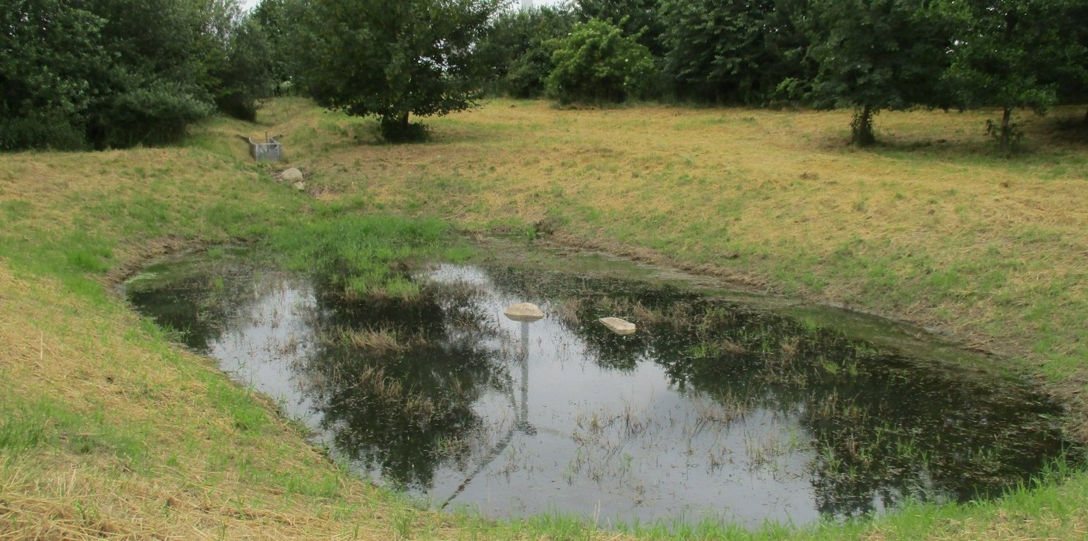
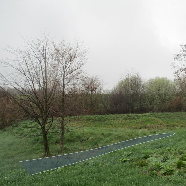
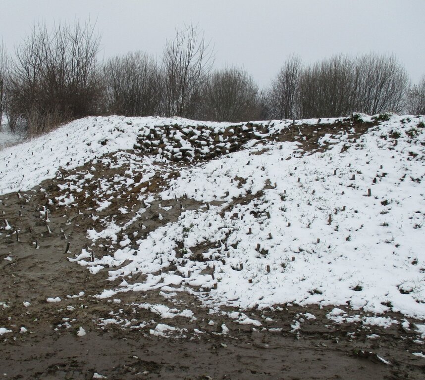
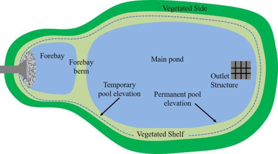
The detention basin described here was constructed by excavating a new depression and ditch system. It consists of a 450 m long inlet channel, a 250 m² pond, and an overflow channel that diverts excess water downstream to the nearest river (Schwarzer Schöps). However, there are no outlet structures for draining water that is captured in the pond (apart from the overflow). All the collected water seeps into the ground and soil particles settle. As a general rule, the size of such a pond should be 3-7% of the upstream catchment and should be able to hold at least the precipitation of a 1 in 30 year rainfall event. However, as the infiltration of the collected water is rather slow, the efficiency is reduced for successive events and overflowing is common. The depth should be between 1.2 m and 2.0 m. A deeper pond can lead to stratification and anoxic conditions, while a shallower pond may cause algal blooms and high biological activity in the summer. Water stored in the pond should remain for at least 20 days to ensure biological treatment.
The construction of the detention pond in this documentation was initiated as a compensation and replacement measure for the construction of a new road in 2016. Accordingly, the road construction authority, the landscape conservation association and a farmer were involved in the implementation.
As usual with such measures there are drawbacks as well as positive impact for landowners. The measure consumes a lot of land, which automatically results in yield losses. It is expensive to build and not easy to construct - and requires the help of an engineering firm while also being time-consuming to maintain. Maintenance is required to sustain the benefits of the technology. For a pond such as that documented here, the following maintenance activities are necessary: during the first three years, maintenance includes mowing the surrounding green area and the dried out pond and channel three times per year. After the fourth year, maintenance includes (a) an annual function check, (b) a check for pest infestation every two years, and (c) suppression of excess woody growth every eight to ten years. Twice a year (mid-June and late August), the grass around the pond and in the intake channel is mowed and the clippings are removed. Shrubs and woody plants are maintained, especially by pruning woody plants (every 8 to 10 years) and coppicing sections of shrubs (every 10 to 15 years). In the long term, it may be necessary to remove the deposited sediments in order to maintain the retention capacity.

地点

地点: Reichenbach, Saxony, 德国

分析的技术场所数量: 单一场所

选定地点的地理参考
  • 14.7681, 51.1411

技术传播: 适用于特定场所/集中在较小区域

在永久保护区?:

实施日期: 10-50年前

介绍类型
Overgrown inlet channel, three years after the opening title photo (in section 1.1) (Felix Witing)
Overflow channel (LISt Gesellschaft für Verkehrswesen und ingenieurtechnische Dienstleistungen mbH, Bereich Kompensationsmaßnahmenmanagement)

技术分类

主要目的
  • 改良生产
  • 减少、预防、恢复土地退化
  • 保护生态系统
  • 结合其他技术保护流域/下游区域
  • 保持/提高生物多样性
  • 降低灾害风险
  • 适应气候变化/极端天气及其影响
  • 减缓气候变化及其影响
  • 创造有益的经济影响
  • 创造有益的社会影响
土地利用
同一土地单元内混合使用的土地: 否

  • 其它 - 具体说明: extensively farmed grassland

供水
  • 雨养
  • 混合雨水灌溉
  • 充分灌溉

土地退化相关的目的
  • 防止土地退化
  • 减少土地退化
  • 修复/恢复严重退化的土地
  • 适应土地退化
  • 不适用
解决的退化问题
  • 土壤水蚀 - Wt:表土流失/地表侵蚀 , Wg:冲沟侵蚀/沟蚀
  • 水质恶化 - Hs:地表水良变化, Hg:地下水/含水层水位的变化
SLM组
  • 集水
  • 减少基于生态系统的灾害风险
SLM措施
  • 结构措施 - S5:大坝、集水斗、水池

技术图纸

技术规范
Securing dam stability by willow sticks.
Author: LISt Gesellschaft für Verkehrswesen und ingenieurtechnische Dienstleistungen mbH, Bereich Kompensationsmaßnahmenmanagement
A detention pond (in genreral) consists of a sediment forebay (pretreatment system), a permanent pool that is intended to remain wet throughout the year (but may dry out), a temporary storage pond for flood attenuation, and a shallow zone or aquatic bench along the edge of the permanent pool to support wetland planting that provides ecological and safety benefits. It should be wedge-shaped with a length to width ratio of between 3:1 and 5:1. The side slope shouldn’t be steeper than 1:3 for public safety and maintenance access.
Author: Hunt et al. (2020)

技术建立与维护:活动、投入和费用

投入和成本的计算
  • 计算的成本为:每个技术单元 (单位:Detention pond (as documented here) volume, length: 225 m², ca. 337,5 m³ (water depth of 1,5m))
  • 成本计算使用的货币:
  • 汇率(换算为美元):1 美元 = 0.91 €
  • 雇用劳工的每日平均工资成本:18.70 € per hour
影响成本的最重要因素
From the government perspective: A budget must be set aside annually for necessary maintenance to ensure functional efficiency.
技术建立活动
  1. remove topsoil (时间/频率: None)
  2. profile water body according to site plan (Standing water 1.5 m deep, ditch 0.5-1.5m deep) (时间/频率: None)
  3. installing of inlet channel (时间/频率: None)
  4. installing erosion protection on embankments (时间/频率: None)
  5. cover the topsoil / terrain profiling (时间/频率: None)
  6. planting of shrubs & aquatic plants along the shoreline (时间/频率: None)
  7. ditch connection to Schwarzer-Schöps (时间/频率: None)
  8. reprofiling ditches (90m) (时间/频率: None)
  9. desilting of drainage ditch to Schwarzer-Schöps (时间/频率: None)
  10. subsequent installation of a spillway (beak structure: 'Schnabelbauwerk') and willow sticks as an erosion control measure for the ditch connection to Schwarzer-Schöps. (时间/频率: None)
总技术建立成本(估算)
25250.0
技术维护活动
  1. completion and development maintenance (mowing of the green area and the water-free water body) (时间/频率: first three years: three times per year)
  2. functional check (时间/频率: after the fourth year: every year)
  3. check for pest infestation (时间/频率: after the fourth year : every other year)
  4. check to suppress unwanted woody growth (时间/频率: after the fourth year: every 8 to 10 years)
  5. grass around the pond and in the intake channel is mowed and the clippings are removed (时间/频率: after the fourth year: twice a year (mid-June and late August))
  6. pruning woody plants (时间/频率: every 8 to 10 years)
  7. putting sections of shrubs on stock (时间/频率: every 10 to 15 years)
总技术维护成本(估算)
618.0

自然环境

年平均降雨量
  • < 250毫米
  • 251-500毫米
  • 501-750毫米
  • 751-1,000毫米
  • 1,001-1,500毫米
  • 1,501-2,000毫米
  • 2,001-3,000毫米
  • 3,001-4,000毫米
  • > 4,000毫米
农业气候带
  • 潮湿的
  • 半湿润
  • 半干旱
  • 干旱
关于气候的规范
Average annual rainfall in mm: 750.82 mm/a
Name of the meteorological station: https://whh-kliwes.de/mapview
Length of growing period (LGP): 209 days
(https://www.umwelt.sachsen.de/dauer-der-vegetationsperiode-30631.html)
斜坡
  • 水平(0-2%)
  • 缓降(3-5%)
  • 平缓(6-10%)
  • 滚坡(11-15%)
  • 崎岖(16-30%)
  • 陡峭(31-60%)
  • 非常陡峭(>60%)
地形
  • 高原/平原
  • 山脊
  • 山坡
  • 山地斜坡
  • 麓坡
  • 谷底
海拔
  • 0-100 m a.s.l.
  • 101-500 m a.s.l.
  • 501-1,000 m a.s.l.
  • 1,001-1,500 m a.s.l.
  • 1,501-2,000 m a.s.l.
  • 2,001-2,500 m a.s.l.
  • 2,501-3,000 m a.s.l.
  • 3,001-4,000 m a.s.l.
  • > 4,000 m a.s.l.
......应用的技术
  • 凸形情况
  • 凹陷情况
  • 不相关
土壤深度
  • 非常浅(0-20厘米)
  • 浅(21-50厘米)
  • 中等深度(51-80厘米)
  • 深(81-120厘米)
  • 非常深(> 120厘米)
土壤质地(表土)
  • 粗粒/轻(砂质)
  • 中粒(壤土、粉土)
  • 细粒/重质(粘土)
土壤质地(地表以下>20厘米)
  • 粗粒/轻(砂质)
  • 中粒(壤土、粉土)
  • 细粒/重质(粘土)
表土有机质含量
  • 高(>3%)
  • 中(1-3%)
  • 低(<1%)
地下水位
  • 表面上
  • < 5米
  • 5-50米
  • > 50米
地表水的可用性
  • 过量
  • 中等
  • 匮乏/没有
水质(未处理)
  • 良好饮用水
  • 不良饮用水(需要处理)
  • 仅供农业使用(灌溉)
  • 不可用
水质请参考: 地表水
盐度是个问题吗?

洪水发生
物种多样性
  • 中等
栖息地多样性
  • 中等

应用该技术的土地使用者的特征

市场定位
  • 生计(自给)
  • 混合(生计/商业)
  • 商业/市场
非农收入
  • 低于全部收入的10%
  • 收入的10-50%
  • > 收入的50%
相对财富水平
  • 非常贫瘠
  • 贫瘠
  • 平均水平
  • 丰富
  • 非常丰富
机械化水平
  • 手工作业
  • 畜力牵引
  • 机械化/电动
定栖或游牧
  • 定栖的
  • 半游牧的
  • 游牧的
个人或集体
  • 个人/家庭
  • 团体/社区
  • 合作社
  • 员工(公司、政府)
性别
  • 女人
  • 男人
年龄
  • 儿童
  • 青年人
  • 中年人
  • 老年人
每户使用面积
  • < 0.5 公顷
  • 0.5-1 公顷
  • 1-2 公顷
  • 2-5公顷
  • 5-15公顷
  • 15-50公顷
  • 50-100公顷
  • 100-500公顷
  • 500-1,000公顷
  • 1,000-10,000公顷
  • > 10,000公顷
规模
  • 小规模的
  • 中等规模的
  • 大规模的
土地所有权
  • 公司
  • 社区/村庄
  • 团体
  • 个人,未命名
  • 个人,有命名
土地使用权
  • 自由进入(无组织)
  • 社区(有组织)
  • 租赁
  • 个人
用水权
  • 自由进入(无组织)
  • 社区(有组织)
  • 租赁
  • 个人
进入服务和基础设施的通道
健康

贫瘠
教育

贫瘠
技术援助

贫瘠
就业(例如非农)

贫瘠
市场

贫瘠
能源

贫瘠
道路和交通

贫瘠
饮用水和卫生设施

贫瘠
金融服务

贫瘠

影响

社会经济影响
灌溉用水的可用性
降低
增加

农业投入费用
增加
降低


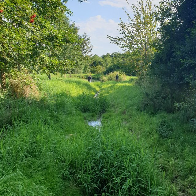
not on agricultural inputs, but establishment and maintenance consume a lot of money.

工作量
增加
降低

社会文化影响
生态影响
水质
降低
增加


Improved water quality of subsequent river Schwarzer-Schöps.

多余水的排放
减少
改良

土壤水分
降低
增加


Soil moisture next to the retention pond increased due to infiltration.

植物多样性
降低
增加


More plant diversity compared to normal farmed grassland.

动物多样性
降低
增加

栖息地多样性
降低
增加

洪水影响
增加
降低

场外影响
水的可用性(地下水、泉水)
降低
增加

地下水/河流污染
增加
减少

成本效益分析

与技术建立成本相比的效益
短期回报
非常消极
非常积极

长期回报
非常消极
非常积极

与技术维护成本相比的效益
短期回报
非常消极
非常积极

长期回报
非常消极
非常积极

气候变化

渐变气候
年降雨量 减少

非常不好
非常好
气候有关的极端情况(灾害)
局地暴雨

非常不好
非常好
热浪

非常不好
非常好

采用和适应

采用该技术的地区内土地使用者的百分比
  • 单例/实验
  • 1-10%
  • 11-50%
  • > 50%
在所有采用这种技术的人当中,有多少人在没有获得物质奖励的情况下采用了这种技术?
  • 0-10%
  • 11-50%
  • 51-90%
  • 91-100%
最近是否对该技术进行了修改以适应不断变化的条件?
什么样的变化条件?
  • 气候变化/极端气候
  • 不断变化的市场
  • 劳动力可用性(例如,由于迁移)

结论和吸取的教训

长处: 土地使用者的观点
  • temporary water-bearing habitat
  • biotopic network
  • buffer effect
长处: 编制者或其他关键资源人员的观点
  • effective flood control and landscape management measure
  • Stores surface runoff, slows it down, and releases it incrementally through controlled runoff, infiltration, or evaporation. Reduces nutrient inputs to adjacent water bodies.
  • aesthetic and cultural value for the society
弱点/缺点/风险: 土地使用者的观点如何克服
  • Danger of siltation and succession if not maintained regularly and professionally.
  • Difficult maintenance due to inaccessible terrain.
弱点/缺点/风险: 编制者或其他关键资源人员的观点如何克服
  • Consumes a lot of land, which means a loss of yield.
  • expensive to build and not easy to construct
  • requires the help of an engineering firm
  • time-consuming to maintain

参考文献

编制者
  • Felix Witing
Editors
  • Michael Strauch
  • Mona Pauer
审查者
  • William Critchley
  • Rima Mekdaschi Studer
实施日期: May 11, 2022
上次更新: Nov. 3, 2023
资源人
WOCAT数据库中的完整描述
链接的SLM数据
文件编制者
机构 项目
链接到网络上可用的相关信息
This work is licensed under Creative Commons Attribution-NonCommercial-ShareaAlike 4.0 International