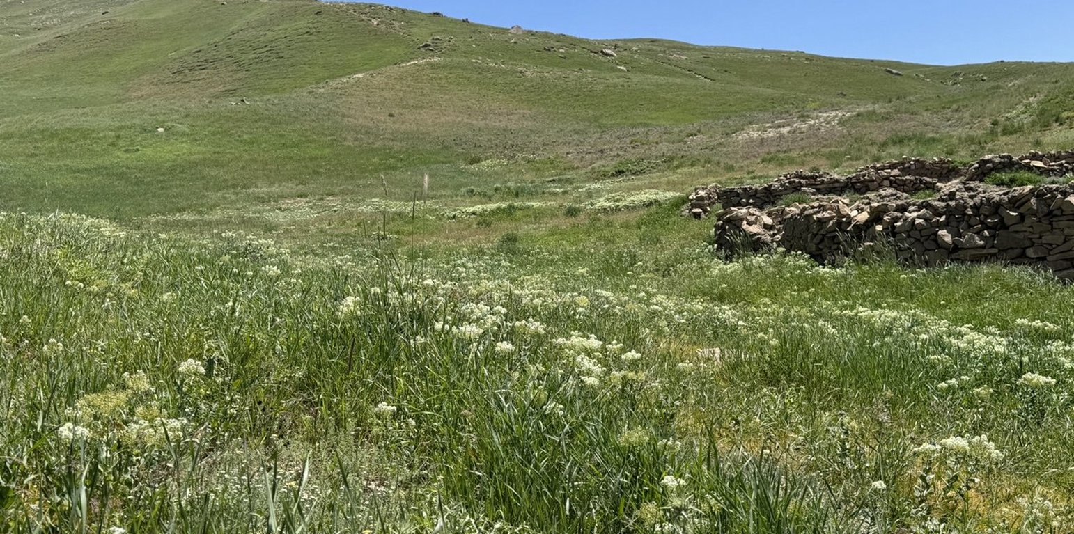
Rangeland after three years of quarantine in Deh Beranj Rangeland Management Association of Qadis district, Badghis, Afghanistan (Shamsulhaq Shams)

Implementing Site Quarantine to reduce rangeland degradation in the highlands of Badghis (阿富汗)

قرنطینه و مدیریت چرا در ارتفاعات بادغیس برای کاهش تخریب مراتع

描述

Restoring degraded rangelands through quarantine in Qadis district, Badghis Afghanistan

The Food and Agriculture Organization (FAO) project of “Community-based sustainable land and forest management in Afghanistan” aimed to promote biodiversity conservation, climate change mitigation, and rangeland productivity through introducing community-based sustainable land and forest management (SLM/SFM) practices in rangeland and forest areas within five targeted provinces, including Badghis, that benefited rural communities that rely on these ecosystems for their livelihood.
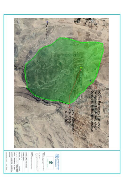
In June 2022, a 1,000-hectare rangeland quarantine area was established to promote the rehabilitation of degraded land and restore the natural vegetation cover. This area was strategically enclosed with clearly marked benchmark boundaries to prevent grazing and ensure its complete protection. By protecting this area from human interference and grazing, the land has been given the opportunity to recover naturally.
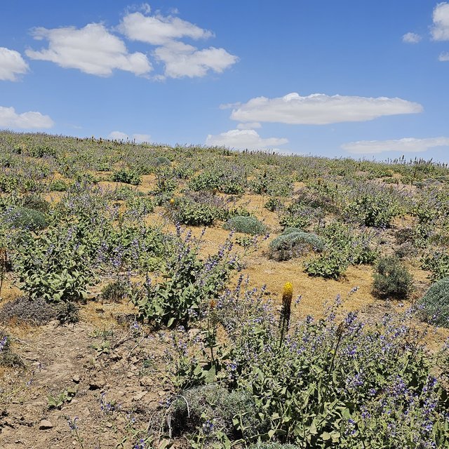
The quarantine area has shown remarkable improvements in the health of its ecosystem. Native grasses, shrubs, and bushes have successfully rehabilitated, with noticeable growth and regeneration. The efforts to protect this area have allowed these plants to thrive without the pressure of overgrazing, leading to the revitalization of the local flora.
A significant outcome of the quarantine area is its role as a natural seed bank. Native seeds collected from this rehabilitated land are now being stored and used for reseeding other degraded rangelands. These seeds, adapted to the local environment, have high potential for successful regeneration when used to restore other areas facing similar ecological challenges. This process not only supports the rehabilitation of nearby rangelands but also contributes to the long-term sustainability and resilience of the local ecosystem.
The success of this quarantine area highlights the importance of protective measures and demonstrates the potential for land recovery through strategic interventions. As a result, this area serves as both a model for rangeland rehabilitation and a valuable resource for future restoration efforts across the region.

地点

地点: Deh Beranj Rangeland Management Association, Qadis district, Badghis province, 阿富汗

分析的技术场所数量: 单一场所

选定地点的地理参考
  • 63.35644, 34.74008

技术传播: 均匀地分布在一个区域 (10.0 km²)

在永久保护区?:

实施日期: 2022; 不到10年前(最近)

介绍类型
Before implementation of quarantine technology (Safiullah Mohammadi)
Regenerated rangeland after implementation of the quarantine technology (Safiullah Mohammadi)

技术分类

主要目的
  • 改良生产
  • 减少、预防、恢复土地退化
  • 保护生态系统
  • 结合其他技术保护流域/下游区域
  • 保持/提高生物多样性
  • 降低灾害风险
  • 适应气候变化/极端天气及其影响
  • 减缓气候变化及其影响
  • 创造有益的经济影响
  • 创造有益的社会影响
土地利用
同一土地单元内混合使用的土地: 否

  • 牧场
    • 半游牧畜牧业
    • 改良牧场
    动物类型: 绵羊
    是否实行作物与牲畜的综合管理?: 否
    产品和服务: 肉类, 奶类
      品种计数
      绵羊50000
    供水
    • 雨养
    • 混合雨水灌溉
    • 充分灌溉

    土地退化相关的目的
    • 防止土地退化
    • 减少土地退化
    • 修复/恢复严重退化的土地
    • 适应土地退化
    • 不适用
    解决的退化问题
    • 土壤水蚀 - Wt:表土流失/地表侵蚀
    • 物理性土壤退化 - Pw:水浸
    • 生物性退化 - Bc:植被覆盖的减少, Bf:火灾的有害影响, Bs:质量和物种组成/多样性的下降
    SLM组
    • 区域封闭(停止使用,支持恢复)
    • 畜牧业和牧场管理
    • 改良的地面/植被覆盖
    SLM措施
    • 植物措施 - V1:乔木和灌木覆盖层
    • 管理措施 - M5:物种组成的控制/变化, M6:废物管理(回收、再利用或减少)

    技术图纸

    技术规范
    •The green area indicates where grasses regenerated. And the GPS shows the exact quarantined area
    •Rangeland quarantine implemented for three years to facilitate the recovery of grasses. By restricting access to degraded areas, we allowed native vegetation to regenerate without disturbance. The grazing exclusion is by social fencing.
    •The benchmark is not a fence but functions as one. Constructed from rocks (1 x 1.5 x 2 meters), the benchmarks are placed every 100 to 200 meters around the rangeland quarantine area to clearly mark its boundaries and prevent or control grazing, ensuring the area remains closed off for recovery
    •Stakeholder involvement through inclusion of local communities in planning and implementation processes.
    Author: Shamsulhaq Shams

    技术建立与维护:活动、投入和费用

    投入和成本的计算
    • 计算的成本为:每个技术区域 (尺寸和面积单位:1000 Ha
    • 成本计算使用的货币:美元
    • 汇率(换算为美元):1 美元 = 75.0
    • 雇用劳工的每日平均工资成本:350 AFN
    影响成本的最重要因素
    Skilled and unskilled labour
    技术建立活动
    1. Survey and site selection followed by feasibility study (时间/频率: 1st month 10/04/2022)
    2. Preparing construction material like rock (时间/频率: 2nd month 08/05/2022)
    3. Construction of benchmark boundaries around the area (时间/频率: 3rd month 01/06/2022)
    4. Capacity building of the target communities (时间/频率: 4th month 05/07/2022)
    5. Hiring guard for patrolling the area (时间/频率: 5th month 01/08/2022)
    技术建立的投入和成本 (per 1000 Ha)
    对投入进行具体说明 单位 数量 单位成本 (美元) 每项投入的总成本 (美元) 土地使用者承担的成本%
    劳动力
    Skilled labour for construction of benchmark person/day 60.0 750.0 45000.0
    Unskilled labour for construction of benchmark person/day 130.0 350.0 45500.0 100.0
    Guard for patrolling the area person/day 2.0 72000.0 144000.0 50.0
    施工材料
    Rock M3 100.0 600.0 60000.0 100.0
    技术建立所需总成本 294'500.0
    技术建立总成本,美元 3'926.67
    技术维护活动
    1. Patrolling the area (时间/频率: All seasons/regular)
    技术维护的投入和成本 (per 1000 Ha)
    对投入进行具体说明 单位 数量 单位成本 (美元) 每项投入的总成本 (美元) 土地使用者承担的成本%
    劳动力
    Guard for patrolling the area person/year 2.0 72000.0 144000.0 50.0
    技术维护所需总成本 144'000.0
    技术维护总成本,美元 1'920.0

    自然环境

    年平均降雨量
    • < 250毫米
    • 251-500毫米
    • 501-750毫米
    • 751-1,000毫米
    • 1,001-1,500毫米
    • 1,501-2,000毫米
    • 2,001-3,000毫米
    • 3,001-4,000毫米
    • > 4,000毫米
    农业气候带
    • 潮湿的
    • 半湿润
    • 半干旱
    • 干旱
    关于气候的规范
    以毫米为单位计算的年平均降雨量:250.0
    Winter (January, February, March)
    Dry periods start from May till November
    Annual temperature is 25 degrees
    斜坡
    • 水平(0-2%)
    • 缓降(3-5%)
    • 平缓(6-10%)
    • 滚坡(11-15%)
    • 崎岖(16-30%)
    • 陡峭(31-60%)
    • 非常陡峭(>60%)
    地形
    • 高原/平原
    • 山脊
    • 山坡
    • 山地斜坡
    • 麓坡
    • 谷底
    海拔
    • 0-100 m a.s.l.
    • 101-500 m a.s.l.
    • 501-1,000 m a.s.l.
    • 1,001-1,500 m a.s.l.
    • 1,501-2,000 m a.s.l.
    • 2,001-2,500 m a.s.l.
    • 2,501-3,000 m a.s.l.
    • 3,001-4,000 m a.s.l.
    • > 4,000 m a.s.l.
    ......应用的技术
    • 凸形情况
    • 凹陷情况
    • 不相关
    土壤深度
    • 非常浅(0-20厘米)
    • 浅(21-50厘米)
    • 中等深度(51-80厘米)
    • 深(81-120厘米)
    • 非常深(> 120厘米)
    土壤质地(表土)
    • 粗粒/轻(砂质)
    • 中粒(壤土、粉土)
    • 细粒/重质(粘土)
    土壤质地(地表以下>20厘米)
    • 粗粒/轻(砂质)
    • 中粒(壤土、粉土)
    • 细粒/重质(粘土)
    表土有机质含量
    • 高(>3%)
    • 中(1-3%)
    • 低(<1%)
    地下水位
    • 表面上
    • < 5米
    • 5-50米
    • > 50米
    地表水的可用性
    • 过量
    • 中等
    • 匮乏/没有
    水质(未处理)
    • 良好饮用水
    • 不良饮用水(需要处理)
    • 仅供农业使用(灌溉)
    • 不可用
    水质请参考: 地下水和地表水
    盐度是个问题吗?

    洪水发生
    物种多样性
    • 中等
    栖息地多样性
    • 中等

    应用该技术的土地使用者的特征

    市场定位
    • 生计(自给)
    • 混合(生计/商业)
    • 商业/市场
    非农收入
    • 低于全部收入的10%
    • 收入的10-50%
    • > 收入的50%
    相对财富水平
    • 非常贫瘠
    • 贫瘠
    • 平均水平
    • 丰富
    • 非常丰富
    机械化水平
    • 手工作业
    • 畜力牵引
    • 机械化/电动
    定栖或游牧
    • 定栖的
    • 半游牧的
    • 游牧的
    个人或集体
    • 个人/家庭
    • 团体/社区
    • 合作社
    • 员工(公司、政府)
    性别
    • 女人
    • 男人
    年龄
    • 儿童
    • 青年人
    • 中年人
    • 老年人
    每户使用面积
    • < 0.5 公顷
    • 0.5-1 公顷
    • 1-2 公顷
    • 2-5公顷
    • 5-15公顷
    • 15-50公顷
    • 50-100公顷
    • 100-500公顷
    • 500-1,000公顷
    • 1,000-10,000公顷
    • > 10,000公顷
    规模
    • 小规模的
    • 中等规模的
    • 大规模的
    土地所有权
    • 公司
    • 社区/村庄
    • 团体
    • 个人,未命名
    • 个人,有命名
    土地使用权
    • 自由进入(无组织)
    • 社区(有组织)
    • 租赁
    • 个人
    用水权
    • 自由进入(无组织)
    • 社区(有组织)
    • 租赁
    • 个人
    进入服务和基础设施的通道
    健康

    贫瘠
    x
    教育

    贫瘠
    x
    技术援助

    贫瘠
    x
    就业(例如非农)

    贫瘠
    x
    市场

    贫瘠
    x
    能源

    贫瘠
    x
    道路和交通

    贫瘠
    x
    饮用水和卫生设施

    贫瘠
    x
    金融服务

    贫瘠
    x

    影响

    社会经济影响
    饲料生产
    降低
    x
    增加

    SLM之前的数量: 500 kg fodder/ hectare
    SLM之后的数量: 900 kg fodder/hectare
    Preventing overgrazing helps maintain plant cover and allows for recovery periods, leading to increased biomass production.

    畜牧生产
    降低
    x
    增加

    SLM之前的数量: 0.5 liter per sheep/day
    SLM之后的数量: 1 liter per sheep/day
    Enhancing the quality and availability of forage provid sheep with a more nutritious diet, which directly impacts milk production.

    饮用水的质量
    降低
    x
    增加

    SLM之前的数量: Contaminated water with minerals
    SLM之后的数量: Leading to clearer and cleaner water
    Effective rangeland management practices enhance the overall health of the ecosystem, leading to improved drinking water quality through better infiltration due to better soil cover and less water runoff.

    社会文化影响
    食品安全/自给自足
    减少
    x
    改良


    Sustainable rangeland management supports local economies by providing livelihoods through livestock production, which can improve food access and self-sufficiency in communities.

    健康状况
    恶化
    x
    改良

    SLM之前的数量: Less nutritious animal products
    SLM之后的数量: More nutritious animal products
    Enhanced forage quality leads to healthier livestock, which provides better quality meat and dairy products, contributing to improved nutrition for communities.

    SLM/土地退化知识
    减少
    x
    改良

    SLM之前的数量: Little capacity building
    SLM之后的数量: Capacity building for 500 members of the Rangeland Management Association
    Training programs for farmers and land managers, increasing their knowledge about sustainable practices and land conservation techniques.

    生态影响
    地表径流
    增加
    x
    降低


    Rangeland improvement practices can significantly reduce surface runoff, enhance soil health, and improve water quality

    多余水的排放
    减少
    x
    改良


    More efficient excess water drainage, enhancing soil structure, reducing waterlogging, and promoting overall ecological health.

    土壤覆盖层
    减少
    x
    改良

    SLM之前的数量: 20% soil cover
    SLM之后的数量: 80-90% soil cover
    Enhanced vegetation cover leads to healthier ecosystems, improved soil conditions, and increased biodiversity.

    植被覆盖层
    降低
    x
    增加

    SLM之前的数量: 20%
    SLM之后的数量: 80-90%
    Enhanced vegetation cover leads to healthier ecosystems, improved soil conditions, and increased biodiversity

    生物量/地上C
    降低
    x
    增加

    SLM之前的数量: 20-30% biomass
    SLM之后的数量: 80-90% biomass
    Rangeland improvement practices significantly boost biomass and above-ground carbon levels, enhancing ecosystem productivity and contributing to carbon sequestration efforts.

    植物多样性
    降低
    x
    增加

    SLM之前的数量: 60/plants per square meter
    SLM之后的数量: 200/plants per square meter
    Enhanced plant diversity leads to healthier ecosystems, increased resilience, and improved overall productivity.

    干旱影响
    增加
    x
    降低

    SLM之前的数量: 500 kg fodder/ha
    SLM之后的数量: 800 kg fodder/ ha
    Rangeland improvement practices significantly mitigate the impacts of drought, enhancing soil moisture retention, vegetation resilience by enhancing the land's ability to retain moisture and support vegetation growth, and overall ecosystem stability.

    碳和温室气体的排放
    增加
    x
    降低

    SLM之前的数量: 80000 m3/ winter season
    SLM之后的数量: 20000 m3/ winter season
    Healthy, diverse plant communities capture and sequester more carbon dioxide through photosynthesis, contributing to greater carbon sequestration and contributing to climate change mitigation efforts.

    场外影响
    下游洪水(不希望)
    增加
    x
    减少

    SLM之前的数量: 10-12 times /year
    SLM之后的数量: Zero floods per year
    Risk and impact of downstream flooding is significantly reduced by enhancing vegetation cover, improving soil health, and promoting better water management.

    温室气体的影响
    增加
    x
    减少

    SLM之前的数量: 20 tons CO2 removed/year
    SLM之后的数量: 50 tons CO2 removed/year
    Healthy rangelands help absorb more carbon in plants and soil, which lowers the amount of CO₂ in the atmosphere. When these lands are grazed properly, they allow perennial and annual grasses to regrow. This regrowth not only captures more carbon but also improves soil health.

    成本效益分析

    与技术建立成本相比的效益
    短期回报
    非常消极
    x
    非常积极

    长期回报
    非常消极
    x
    非常积极

    与技术维护成本相比的效益
    短期回报
    非常消极
    x
    非常积极

    长期回报
    非常消极
    x
    非常积极

    Improved rangelands often lead to higher forage yields, supporting larger and healthier livestock populations. This can result in increased income for land users.

    气候变化

    渐变气候
    年温度 减少

    非常不好
    x
    非常好
    年降雨量 增加

    非常不好
    x
    非常好
    气候有关的极端情况(灾害)
    局地风暴

    非常不好
    x
    非常好
    热浪

    非常不好
    x
    非常好
    干旱

    非常不好
    x
    非常好
    山洪暴发

    非常不好
    x
    非常好

    采用和适应

    采用该技术的地区内土地使用者的百分比
    • 单例/实验
    • 1-10%
    • 11-50%
    • > 50%
    在所有采用这种技术的人当中,有多少人在没有获得物质奖励的情况下采用了这种技术?
    • 0-10%
    • 11-50%
    • 51-90%
    • 91-100%
    最近是否对该技术进行了修改以适应不断变化的条件?
    什么样的变化条件?
    • 气候变化/极端气候
    • 不断变化的市场
    • 劳动力可用性(例如,由于迁移)

    结论和吸取的教训

    长处: 土地使用者的观点
    • Rangeland quarantine allow for better management of pasture resources leading to improved pasture and grass quality.
    • Rangeland quarantine increased productivity can maximize the land's carrying capacity leading to higher livestock productivity per unit area.
    • Rangeland quarantine helps prevent overgrazing, reduces parasite loads, minimizes soil compaction, and allows for more natural feeding behaviors, all of which contribute to overall animal health.
    • Reduce greenhouse gas emissions through carbon sequestration.
    • Properly managed rangeland quarantine can promote biodiversity by creating varied habitats and supporting a range of plant and animal species.
    • Implementing rangeland quarantine can lead to knowledge transfer among farmers, researchers, and agricultural extension services, fostering innovation and best practices in sustainable land management.
    长处: 编制者或其他关键资源人员的观点
    弱点/缺点/风险: 土地使用者的观点如何克服
    • Ensuring the right number of animals on each grazing area can be challenging, leading to risks of overgrazing or underutilization. Stocking rate management.
    • Rangeland quarantine can lead to social conflicts among different user groups, such as conflicting interests between livestock owners, conservationists, and indigenous communities. Facilitating dialogue among stakeholders, promoting collaborative rangeland management approaches, respecting traditional land tenure systems, and fostering community-based conflict resolution mechanisms can help manage.
    弱点/缺点/风险: 编制者或其他关键资源人员的观点如何克服
    • When grazing animals are quarantined, their numbers may increase in certain areas, leading to overgrazing. This can result in habitat degradation and loss of plant diversity. Implement managed grazing systems to control population densities and prevent overgrazing. This can include rotational grazing practices.

    参考文献

    编制者
    • Shamsulhaq Shams
    Editors
    • Mir Wali Khan Lakanwal
    • Mohammad Mustafa Sahebzada
    • Obaidullah Durani
    • Megha bajaj
    审查者
    • Rima Mekdaschi Studer
    • Illias Animon
    • Muhammad Ishaq Safi
    实施日期: Dec. 19, 2024
    上次更新: March 24, 2025
    资源人
    WOCAT数据库中的完整描述
    链接的SLM数据
    文件编制者
    机构 项目
    This work is licensed under Creative Commons Attribution-NonCommercial-ShareaAlike 4.0 International