Participatory development of surface model (Ankita Yadav)
CoDriVE-VI (Community-driven Vulnerability Evaluation – Visual Integrator) is a participatory approach developed by the Watershed Organisation Trust (WOTR) to support sustainable groundwater management. It aims to demystify the invisible subsurface and make aquifer systems understandable to rural communities by combining scientific tools with local knowledge in a hands-on, visual format. While the process is facilitated by WOTR, communities are placed at the center of the process, contributing traditional insights, assisting with data collection, and actively participating in constructing and interpreting the 3D model. Thus, the approach is best described as participatory, with strong elements of community ownership and engagement.
The “Visual Integrator” refers to the integration of both surface and subsurface data—such as topography, drainage, geology, well inventory details, and geophysical survey results—into a tangible, scaled three-dimensional model. This participatory 3D modelling (P3DM) process helps communities visualize how aquifers relate to the landscape, showing key features such as recharge zones, discharge points, and areas of intensive groundwater extraction.
“Vulnerability evaluation” is carried out through the community’s participatory analysis of the model. Using the integrated visual platform, villagers can identify zones that are more vulnerable to depletion—such as those with low recharge, high borewell density, or historically declining water tables. While a formal vulnerability matrix is not used, the 3D model serves as a practical vulnerability map. It guides discussions and decisions around water budgeting, aquifer recharge, crop-water planning, and the development of informal rules for responsible groundwater use.
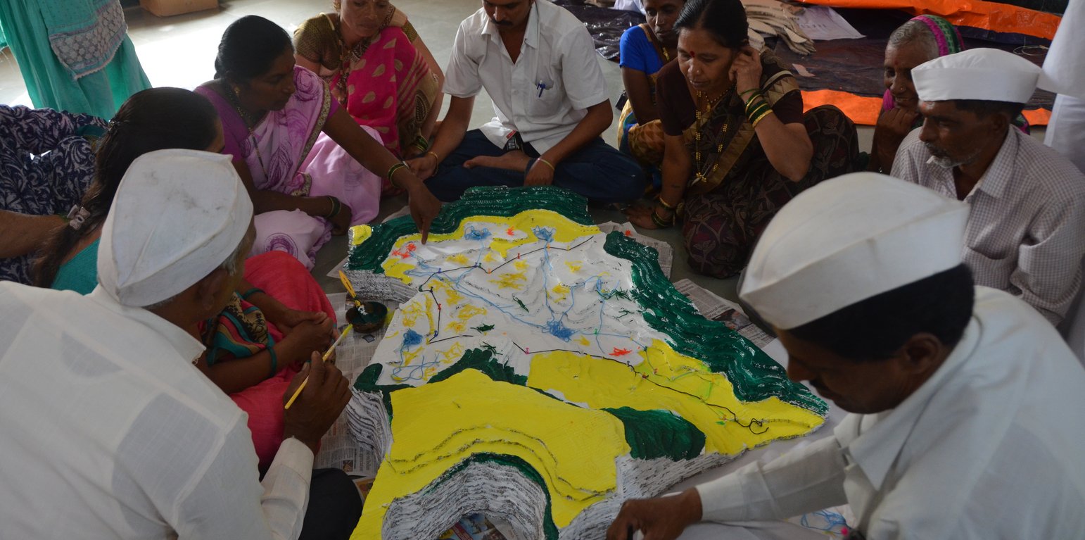
The methodology combines participatory rural appraisal with hydrogeological and geospatial techniques. After an initial orientation and trust-building phase, communities help map surface features. Subsurface data is then collected through geological mapping, well inventory surveys, and geophysical methods like Vertical Electrical Sounding (VES). The data are analyzed using GIS tools and inverse slope modelling. The 3D model is then constructed using layered cardboard sheets, with communities contributing throughout the process—cutting, assembling, painting, and validating the layers.
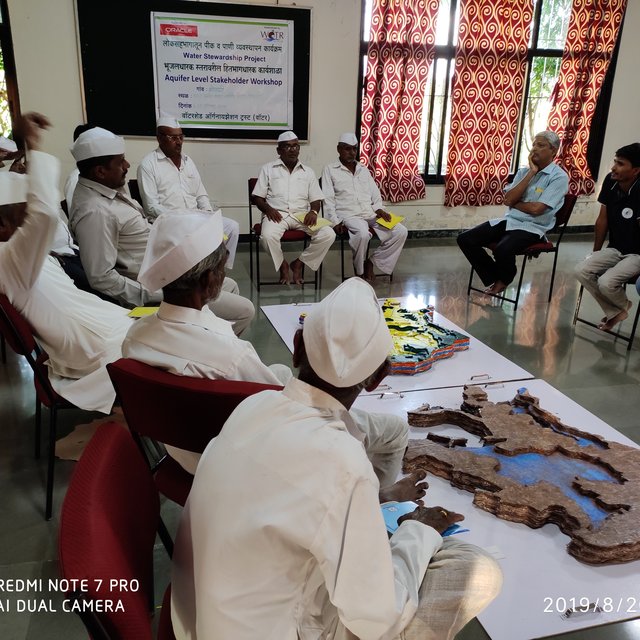
The CoDriVE-VI process unfolds in several stages: community mobilization and planning; surface and subsurface data collection; model building in participatory workshops; and result interpretation and management planning. Key stakeholders include community members, WOTR facilitators, technical experts (geologists and GIS specialists), and local governance representatives.
Participants found the visual models highly effective in helping them grasp aquifer dynamics, leading to a shift in perception—from seeing groundwater as an individual entitlement to recognizing it as a shared resource. This in turn fostered collective decision-making. The approach has also contributed to improved groundwater literacy, informed water budgeting, and motivated some villages to initiate local groundwater governance practices.
While climate change is a key driver of groundwater stress, the approach also acknowledges other socio-economic and environmental pressures—such as population growth, land-use change, deforestation, and the uncontrolled proliferation of borewells—as critical factors influencing groundwater vulnerability. By visualizing these interconnections, CoDriVE-VI supports more holistic and sustainable groundwater management at the community level.
地点: Darewadi,Post. Kauthe Malkapur Tal. Sangamner, Dist. Ahilyanagar, Maharashtra, Maharashtra, 印度
启动日期: 2017
终止年份: 不适用
方法的类型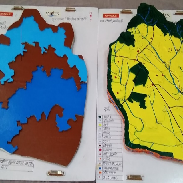
| 该方法涉及哪些利益相关者/执行机构? | 指定利益相关者 | 说明利益相关者的角色 |
| 当地土地使用者/当地社区 | Villagers and farmers from Ahilyanagar and Jalna districts, Maharashtra | They participated actively in the mapping exercises, provided indigenous knowledge on topography and land use, contributed to well inventory and aquifer-related insights, and were directly involved in building the 3D models. Their engagement was central in interpreting subsurface information and applying it to groundwater planning. |
| 社区组织 | Village Water Management Committees, Water Stewardship groups | Helped mobilize community members, facilitated communication between villagers and technical teams, and supported local-level planning and rule-setting for groundwater use. |
| SLM专家/农业顾问 | WOTR technical staff and hydrogeology facilitators | Provided scientific inputs on geology and hydrogeology, conducted well and geophysical surveys, interpreted data, supported the construction of groundwater potential maps, and trained community members in groundwater management |
| 研究人员 | Researchers and field investigators from WOTR and contributing institutions | Developed the methodology, documented experiences, synthesised scientific and community knowledge, and analysed feedback for continuous improvement of the tool. |
| NGO | Watershed Organisation Trust (WOTR) | Lead agency responsible for conceptualizing, facilitating, implementing, and documenting the approach. Conducted workshops, managed technical assessments, trained field teams, and engaged communities. |
| 私营部门 | HSBC Software Development India (as supporter) | Provided financial support for printing and disseminating the CoDriVE-VI manual. |
| 地方政府 | Gram Panchayat members, Sarpanches | Participated in workshops, helped validate maps and data, encouraged community participation, and supported local rule-making for sustainable groundwater use. |
| 国家政府(规划者、决策者) | Indirectly linked via supportive policies (e.g., Atal Bhujal Yojana, National Aquifer Management Project (NAQUIM)) | Although not directly involved in implementation, national policies provided support for the overall context and justification of aquifer-based participatory planning and water budgeting. |
| 国际组织 | ProSoil project (GIZ) | Supported in publishing and promoting the CoDriVE-VI manual, including showcasing it at UNCCD COP14 |
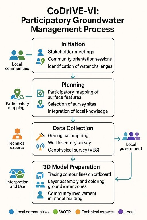
The visual summary illustrates the four key stages of the CoDriVE-VI approach
Initiation
-Stakeholder meetings and community orientation sessions are conducted.
-Local water-related challenges are identified.
-Builds a foundation for participatory engagement and problem recognition.
Planning
-Participatory mapping of surface features is carried out.
-Survey sites are selected based on local inputs and technical feasibility.
-Local knowledge is integrated with scientific planning.
Data Collection
-Technical experts conduct geological mapping and well inventory surveys.
- Geophysical surveys (e.g., Vertical Electrical Sounding - VES) are performed.
- Scientific data on groundwater systems is gathered for model development.
3D Model Preparation
-Contour lines are traced on cardboard to build physical models.
-Groundwater zones are assembled and color-coded.
-Communities are actively involved in model building and interpretation for better understanding and use.
决策是由......做出的
决策是基于
•Basic concepts of hydrogeology and aquifers
•Groundwater vulnerability and common pool resource concepts
•Surface and subsurface mapping
•Use of Participatory 3D Modelling (P3DM)
•Groundwater budgeting
•Climate change impacts on water resources
•Community-led planning and rule-setting for water use
Research was integral to developing and refining the CoDriVE methodology. Hydrogeologists and social scientists collaborated with local communities to understand groundwater systems and social dynamics influencing water use. Technology research focused on participatory 3D modeling tools and groundwater budgeting techniques. WOTR staff, partnered with academic institutions and experts in hydrogeology, led the research activities. Community feedback was also systematically documented to improve approaches.
Labour costs for technical support and community mobilization were partly supported by the implementing agency or development partners
土地使用者的劳动力为
Supportive policies included local water governance regulations encouraging sustainable groundwater use and community rule enforcement. NGO advocacy helped secure government backing for participatory water management.
The participatory 3D modelling process directly involved villagers in mapping and decision-making. It created a sense of shared ownership over groundwater resources, enabling community-level rule-making and active participation in groundwater governance
Scientific tools such as geophysical surveys, geological mapping, and GIS-based groundwater potential maps enabled villagers to base water management decisions on accurate data integrated with traditional knowledge
By making aquifer dynamics visible, the approach supported sustainable agricultural planning and water budgeting, which are part of SLM practices, although it focused more on literacy and awareness than direct technology implementation
It fostered collaboration among community members, local institutions, and technical experts, creating alignment in groundwater-related decisions.
The approach was low-cost and supported by NGOs and donor funding.
The process enhanced groundwater literacy, built capacity for aquifer-based planning, and enabled villagers to understand recharge/discharge zones and water budgeting.
Local government representatives and NGO facilitators gained insights into how to communicate complex hydrogeological data using participatory tools, enhancing their capacity to support SLM.
Village Water Committees and informal community groups were strengthened through workshops, joint planning, and shared understanding of groundwater resources
By visualizing the shared nature of groundwater resources, it reduced the perception of groundwater as private property and encouraged collective action, which can mitigate user-level conflicts.
The approach was inclusive and community-wide. Women’s participation was specifically encouraged, though economic empowerment was not a primary focus.
Women were involved in workshops and discussions, recognizing their central role in water use.
The participatory and educational nature of the tool could be adapted for such use.
The approach challenged the perception of groundwater as an individual property, promoting a common-pool perspective.
While not directly linked, improved water planning and sustainable groundwater use could contribute indirectly to more reliable irrigation and reduced crop failure.
By improving groundwater management and awareness, the approach contributed to more sustainable access to water for drinking and agriculture.
The tool helped communities understand climate variability's impact on aquifers, supported water risk assessment, and promoted resilience through informed water use planning.
Indirect employment through training, facilitation, and workshops was possible.


