Monitoring and Management of Agroforestry using SmartAG [葡萄牙]
- 创建:
- 更新:
- 编制者: Patrícia Lourenço
- 编辑者: –
- 审查者: Joana Eichenberger, William Critchley, Rima Mekdaschi Studer
Agroforestry in Montado and Dehesa
technologies_7126 - 葡萄牙
查看章节
全部展开 全部收起1. 一般信息
1.2 参与该技术评估和文件编制的资源人员和机构的联系方式
关键资源人
SLM专业人员:
Lourenço Patrícia
AgroInsider
葡萄牙
SLM专业人员:
Marques da Silva José Rafael
AgroInsider
葡萄牙
SLM专业人员:
Paixão Luís
AgroInsider
葡萄牙
有助于对技术进行记录/评估的项目名称(如相关)
Land Use Based Mitigation for Resilient Climate Pathways (LANDMARC)1.3 关于使用通过WOCAT记录的数据的条件
编制者和关键资源人员接受有关使用通过WOCAT记录数据的条件。:
是
1.4 所述技术的可持续性声明
这里所描述的技术在土地退化方面是否存在问题,导致无法被认为是一种可持续的土地管理技术?:
否
2. SLM技术的说明
2.1 技术简介
技术定义:
The Montado/ Dehesa Agroforestry system contributes to carbon sequestration in Spain and Portugal. The SmartAG app helps in monitoring and management of these systems, providing data available to farmers, producers, and stakeholders.
2.2 技术的详细说明
说明:
The SmartAG model is mainly applied in the Montado (Portugal) and Dehesa (Spain) agroforestry systems which serve as a biodiversity oasis in the
Mediterranean region. They are currently being heavily impacted by climate change.
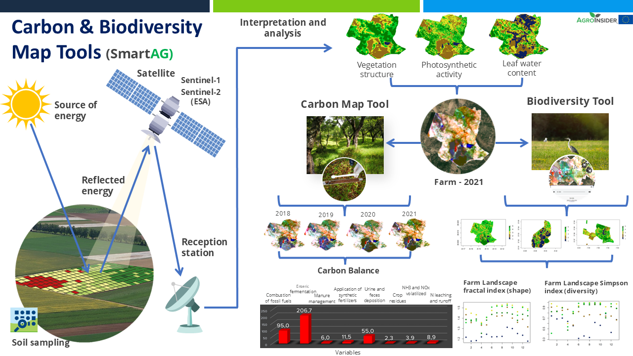
It contributes to achieving carbon sequestration potential. The SmartAG model is also applied in agriculture systems in Portugal, Spain, Greece, The Netherlands, Indonesia and Ukraine. Nevertheless, it can be applied in any part of the world. The SmartAG app provides accurate Agricultural Climate Services on a large-scale, available to farmers, producers, and stakeholders. The model analyzes agronomic anomalies to reduce CO2 emissions and promote CO2 sequestration in the soil, via remote sensing. Additionally, it seeks to remotely analyze farms by evaluating the spatiotemporal dynamics occurring in agroforestry activities for the same purposes.
Through data collection on land use, mapping, remote sensing and in situ data collection, an assessment of the initial state of the farm is carried out, along a carbon balance, to establish a reference scenario (baseline year). Future projections are made, and recommendations formulated.
Users appreciate this methodology because it helps them conserve or increase current carbon stocks, potentially creating a new source of income through the sale
of carbon credits. SmartAG is a highly user-friendly app which records georeferenced evidence of existing conditions and activities. It facilitates a transparent and participatory process in agroforestry ecosystem management.
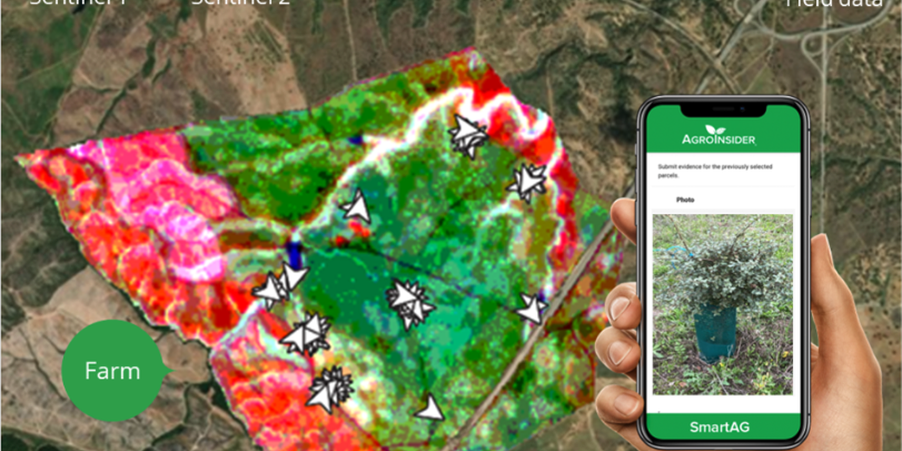
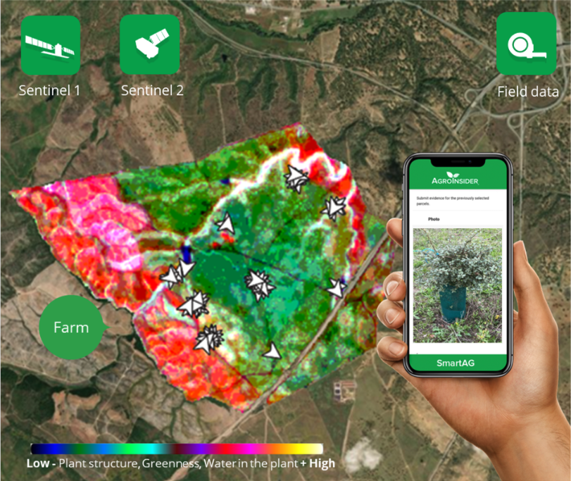
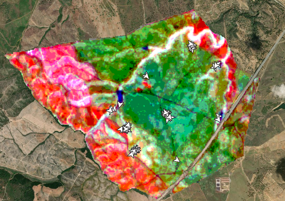
SmartAG automatically processes data from Sentinel-1 and Sentinel-2 data, and LST data for thermo-climatic zoning. These data: i) allow monitoring, reporting and verification of farms; ii) provide machine learning capabilities in agroforestry and environmental data.
Based on Sentinel data, spectral vegetation indices are calculated to identify: i) crop anomalies related to soil-water-plant; ii) management zones to define different land uses, the selection of sampling locations and sensor installation sites, water sampling locations, and identification of species for biodiversity quantification.
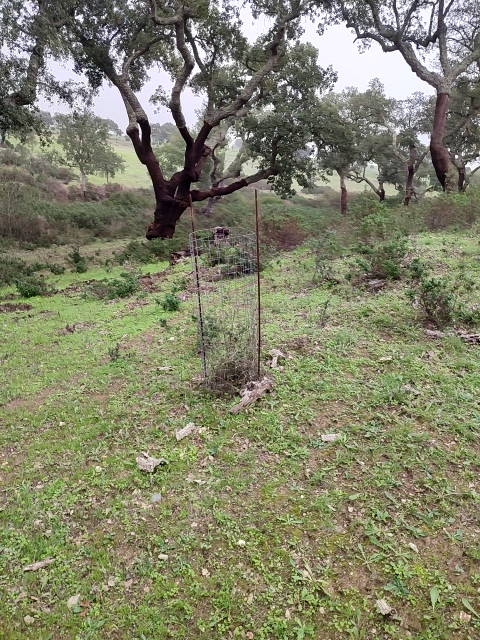
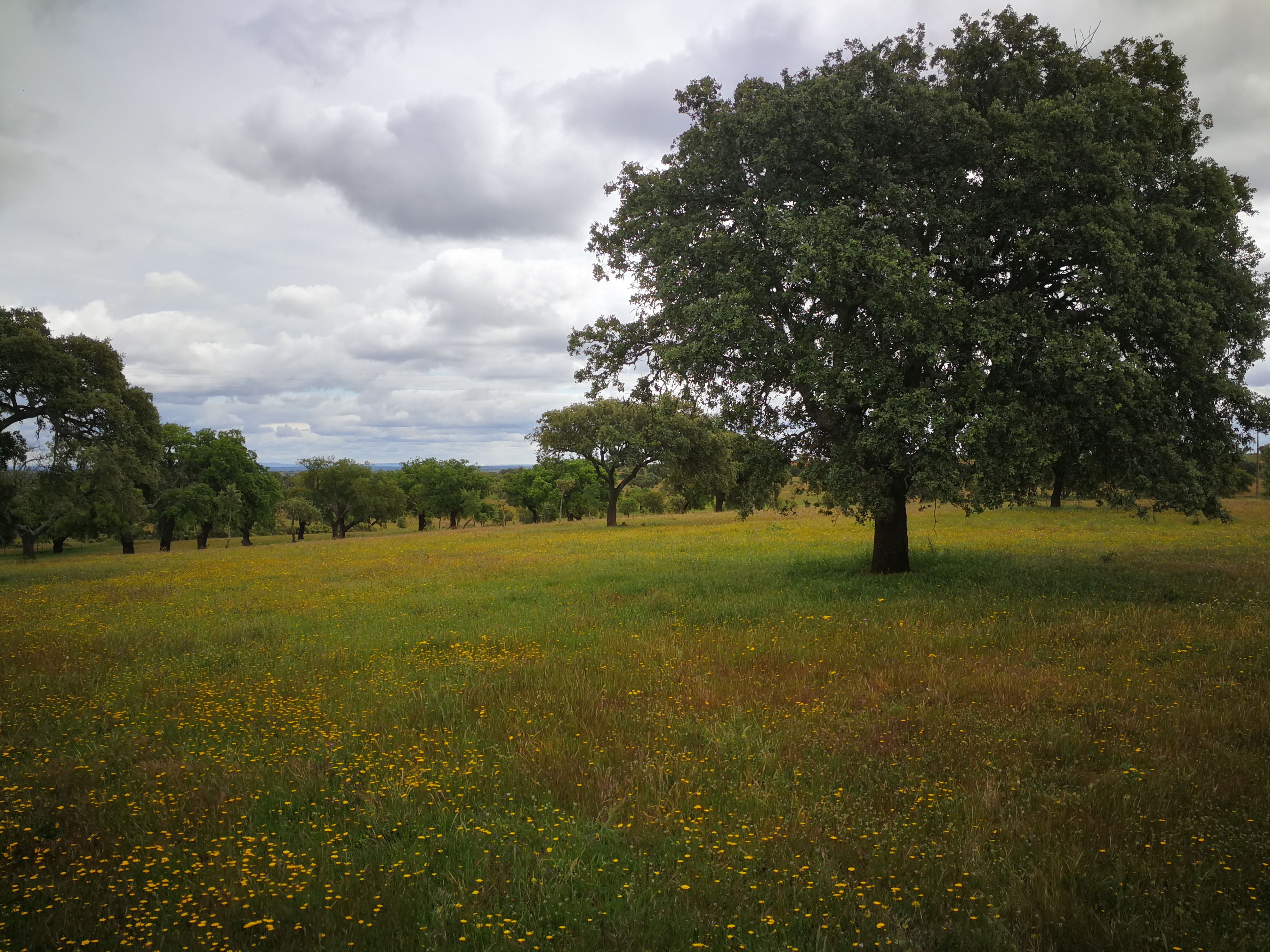
The Montado/Dehesa is a slow-developing and very complex agroforestry system meaning that differences will be observable only at the end of a year or longer. In addition, it is a highly stratified system, consisting of a complex arboreal structure with trees of different ages, shrubs, and herbaceous vegetation. Given the limitations of Sentinel-1 and Sentinel-2 satellites it is essential to record georeferenced evidence of these. Using SmartAG app developed by AgroInsider allows the collection of georeferenced evidence (e.g., photos, audios, and videos) of
the vegetation structures, as well as documenting evidence of processes occurring such as ecosystem services and biodiversity. Georeferenced evidence is automatically uploaded into the system.
2.3 技术照片
媒体库
2.4 技术视频
注释、简短说明:
https://www.youtube.com/watch?v=zxKjnAAkSI0
日期:
16/06/2023
位置:
Évora, Portugal
摄影师的名字:
Filipa Santos
2.5 已应用该技术的、本评估所涵盖的国家/地区/地点
国家:
葡萄牙
区域/州/省:
Alentejo
具体说明该技术的分布:
- 均匀地分布在一个区域
如果技术均匀分布在一个区域,则指定覆盖的区域(单位为平方千米):
100000.0
技术现场是否位于永久保护区?:
是
如果是,请具体说明:
Montado and Dehesa constitute a Very High Nature Value agroforestry system which is under protection.
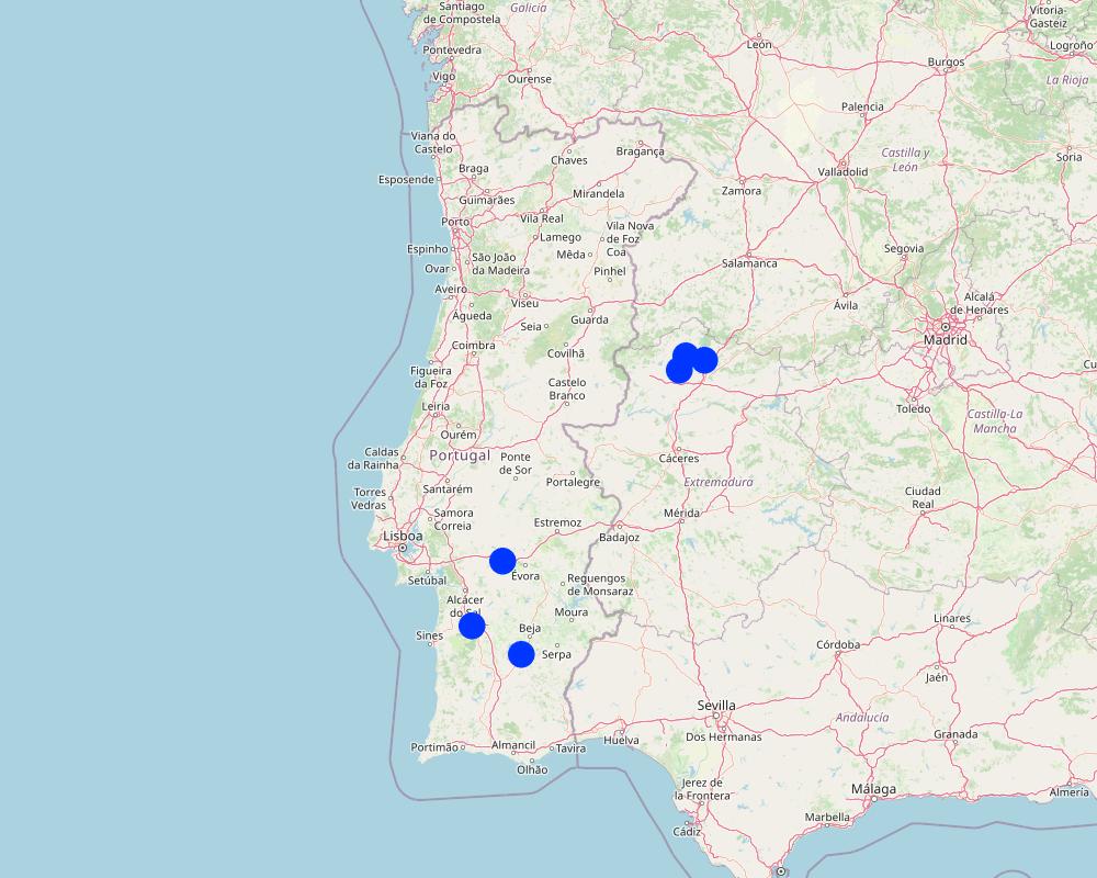
Map
×2.6 实施日期
注明实施年份:
2023
2.7 技术介绍
详细说明该技术是如何引入的:
- 在实验/研究期间
注释(项目类型等):
In 2023 AgroInsider started the implementation of the LMT and SmartAG monitoring in Agroforestry system case studies in Montado, in Portugal, and Dehesa, in Spain.
3. SLM技术的分类
3.1 该技术的主要目的
- 减少、预防、恢复土地退化
- 保护生态系统
- 结合其他技术保护流域/下游区域
- 保持/提高生物多样性
- 减缓气候变化及其影响
3.2 应用该技术的当前土地利用类型
同一土地单元内混合使用的土地::
是
具体说明混合土地使用(作物/放牧/树木):
- 农林牧业

牧场
粗放式放牧:
- 经营牧场
- 季节性迁移的放牧主义
集约放牧/饲料生产:
- 改良牧场
动物类型:
- 牛 - 非奶牛牛肉
- 家禽
- 绵羊
是否实行作物与牲畜的综合管理?:
否
产品和服务:
- 肉类
- 奶类
- 毛料
品种:
绵羊
计数:
40
品种:
cattle - dairy and beef (e.g. zebu)
计数:
40

森林/林地
- (半天然)天然森林/林地
(半天然)天然森林/林地:具体说明管理类型:
- 清除枯木/剪枝
- Mediterranean Agroforestry System (Montado/Dehesa)
- cork holm, cork oak
以上的树木是落叶树还是常绿树?:
- 常绿
产品和服务:
- 水果和坚果
- 自然保持/保护
- cork
3.3 由于技术的实施,土地使用是否发生了变化?
由于技术的实施,土地使用是否发生了变化?:
- 否(继续问题3.4)
3.4 供水
该技术所应用土地的供水:
- 雨养
3.5 该技术所属的SLM组
- 农业林学
- 畜牧业和牧场管理
- 改良的地面/植被覆盖
3.6 包含该技术的可持续土地管理措施

植物措施
- V1:乔木和灌木覆盖层
- V2:草和多年生草本植物

管理措施
- M1:改变土地使用类型
- M2:改变管理/强度级别
3.7 该技术强调的主要土地退化类型

化学性土壤退化
- Cn:肥力下降和有机质含量下降(非侵蚀所致)
- Ca:酸化

物理性土壤退化
- Pc:压实
3.8 防止、减少或恢复土地退化
具体数量名该技术与土地退化有关的目标:
- 防止土地退化
- 减少土地退化
4. 技术规范、实施活动、投入和成本
4.1 该技术的技术图纸
技术规范(与技术图纸相关):
The LMT will be implemented on a farm with montado/dehesa (minimum area of 100 ha). Satellite data is used to characterize land use. After identifying the montado/dehesa area, field sampling is conducted. These data, along with satellite imagery, will be used to calculate the total CO2eq stock (above and below ground biomass) and estimate CO2eq sequestration. Farmers are encouraged to enhance LMT effectiveness, notably by engaging in ecosystem-value activities such as avoiding soil disturbance to preserve soil organic matter, increasing tree density, and maintaining water mirrors. Farmers will record georeferenced evidence of improvement activities and existing biodiversity in the montado and in other areas of the farm using the SmartAG developed by AgroInsider. This app will allow to monitor, report and verify carbon stocks through weekly alert reports, enabling the identification of carbon anomalies/losses over time and space.
作者:
Patrícia Lourenço
日期:
23/04/2024
4.2 有关投入和成本计算的一般信息
具体说明成本和投入是如何计算的:
- 每个技术区域
注明尺寸和面积单位:
100 ha
其它/国家货币(具体说明):
Euro (€)
注明雇用劳工的每日平均工资成本:
3590 €
4.3 技术建立活动
| 活动 | 时间(季度) | |
|---|---|---|
| 1. | Select a farm with montado/dehesa (minimum area of 100 ha) | In the baseline year |
| 2. | Characterization of the land use using satellite data in the baseline year | In the baseline year |
| 3. | Field sampling in the montado/dehesa area | In the baseline year |
| 4. | Field data along with satellite imagery will be used to calculate the total CO2eq stock (above and below ground biomass) and estimate CO2eq sequestration | In the baseline year |
| 5. | Farmers are encouraged to enhance LMT effectiveness, notably by engaging in ecosystem-value activities such as avoiding soil disturbance to preserve soil organic matter, increasing tree density, and maintaining water mirrors | In the baseline year |
| 6. | Farmers will record georeferenced evidence of improvement activities and existing biodiversity in the montado and in other areas of the farm using the SmartAG developed by AgroInsider | Whenever farmers go to the field |
| 7. | After calculating the CO2eq stock and CO2eq sequestration estimates for the baseline year, SmartAG will allow to monitor, report and verify (MRV) carbon stocks through weekly alert reports. The MRV will enable the identification of carbon anomalies/losses over time and space | Weekly |
4.4 技术建立所需要的费用和投入
| 对投入进行具体说明 | 单位 | 数量 | 单位成本 | 每项投入的总成本 | 土地使用者承担的成本% | |
|---|---|---|---|---|---|---|
| 劳动力 | Data preprocessing before heading to the field | Hour | 4.0 | 20.0 | 80.0 | 0.0 |
| 劳动力 | Field data collection | Hour | 24.0 | 20.0 | 480.0 | 0.0 |
| 劳动力 | Post-processing of field and satellite data | Hour | 4.0 | 20.0 | 80.0 | 0.0 |
| 劳动力 | Improvement suggestions | Hour | 8.0 | 20.0 | 160.0 | 0.0 |
| 劳动力 | Emission estimates | Hour | 40.0 | 20.0 | 800.0 | 0.0 |
| 设备 | Car renting | Day | 1.0 | 60.0 | 60.0 | 0.0 |
| 设备 | Fuel | Km | 350.0 | 0.4 | 140.0 | 0.0 |
| 植物材料 | Soil sampling | Samples | 3.0 | 70.0 | 210.0 | 0.0 |
| 其它 | 1.0 | |||||
| 技术建立所需总成本 | 2010.0 | |||||
| 技术建立总成本,美元 | 2010.0 | |||||
如果土地使用者负担的费用少于100%,请注明由谁负担其余费用:
The costs are covered by AgroInsider
注释:
This value varies depending on the distance from AgroInsider's headquarters to the farm, the farm's area, and carbon-emitting farm activities (i.e., agricultural activities).
4.5 维护/经常性活动
| 活动 | 时间/频率 | |
|---|---|---|
| 1. | Calculate the total CO2eq stock (above and below ground biomass) and estimate CO2eq sequestration | In the baseline year |
| 2. | MRV carbon stocks | Weekly |
| 3. | Record georeferenced evidence | Whenever farmers go to the field |
4.7 影响成本的最重要因素
描述影响成本的最决定性因素:
Human resources, farm area, and the quantity of carbon-emitting farm activities (i.e., agricultural activities).
5. 自然和人文环境
5.1 气候
年降雨量
- < 250毫米
- 251-500毫米
- 501-750毫米
- 751-1,000毫米
- 1,001-1,500毫米
- 1,501-2,000毫米
- 2,001-3,000毫米
- 3,001-4,000毫米
- > 4,000毫米
有关降雨的规范/注释:
Montado/Dehesa is influenced by the Mediterranean climate, characterized by a great variability in precipitation and temperature in each year and between years, presenting a hot summer lasting more than four months, associated with a high irregularity in precipitation, both inter- and intra-annually. In this climate, natural droughts are recurrent.
农业气候带
- 半干旱
More recent data for the agricultural years 2015/2016, 2016/2017, and 2017/2018 report values for cumulative precipitation for the Évora region (Alentejo) of 547 mm, 421 mm, and 612 mm, respectively. However, in the same region, in the 2018/2019 crop year, there was only 315 mm of precipitation, while in the following year, this value already reached 627 mm.
It is common in the Alentejo region to have several days with temperatures above 40 ◦C in summer and with minimum temperatures below 0 ◦C in winter. In the Estremadura region, the average minimum temperature recorded was 3.4 ◦C, and the average maximum temperature was 35.6 ◦C.
5.2 地形
平均坡度:
- 水平(0-2%)
- 缓降(3-5%)
- 平缓(6-10%)
- 滚坡(11-15%)
- 崎岖(16-30%)
- 陡峭(31-60%)
- 非常陡峭(>60%)
地形:
- 高原/平原
- 山脊
- 山坡
- 山地斜坡
- 麓坡
- 谷底
垂直分布带:
- 0-100 m a.s.l.
- 101-500 m a.s.l.
- 501-1,000 m a.s.l.
- 1,001-1,500 m a.s.l.
- 1,501-2,000 m a.s.l.
- 2,001-2,500 m a.s.l.
- 2,501-3,000 m a.s.l.
- 3,001-4,000 m a.s.l.
- > 4,000 m a.s.l.
说明该技术是否专门应用于:
- 不相关
5.3 土壤
平均土层深度:
- 非常浅(0-20厘米)
- 浅(21-50厘米)
- 中等深度(51-80厘米)
- 深(81-120厘米)
- 非常深(> 120厘米)
土壤质地(表土):
- 粗粒/轻(砂质)
- 中粒(壤土、粉土)
土壤质地(地表以下> 20厘米):
- 粗粒/轻(砂质)
- 中粒(壤土、粉土)
表土有机质:
- 中(1-3%)
5.4 水资源可用性和质量
地表水的可用性:
匮乏/没有
水质(未处理):
仅供农业使用(灌溉)
水的盐度有问题吗?:
否
该区域正在发生洪水吗?:
否
5.5 生物多样性
物种多样性:
- 中等
栖息地多样性:
- 高
关于生物多样性的注释和进一步规范:
The Agroforestry system Montado, in Portugal, and Dehesa, in Spain, is a High Nature Value system characterized by a high complexity because of the interactions between climate, soil, pasture (natural pastures, fertilized natural pastures, and sown biodiverse permanent pastures rich in legumes), trees (e.g., pure or mix stands of cork oak, holm oak, stone pine), and animals (e.g., sheep, pigs, cows, goats). Montado/Dehesa is one of the most prominent and best preserved low-intensity farming systems in Europe. The integration of traditional land-use and biodiversity conservation that is characteristic of this system is an exemplar for the wise management of the countryside.
5.6 应用该技术的土地使用者的特征
定栖或游牧:
- 定栖的
生产系统的市场定位:
- 混合(生计/商业)
非农收入:
- 收入的10-50%
相对财富水平:
- 平均水平
个人或集体:
- 个人/家庭
- 合作社
机械化水平:
- 机械化/电动
性别:
- 女人
- 男人
土地使用者的年龄:
- 中年人
- 老年人
5.7 应用该技术的土地使用者使用的平均土地面积
- < 0.5 公顷
- 0.5-1 公顷
- 1-2 公顷
- 2-5公顷
- 5-15公顷
- 15-50公顷
- 50-100公顷
- 100-500公顷
- 500-1,000公顷
- 1,000-10,000公顷
- > 10,000公顷
这被认为是小规模、中规模还是大规模的(参照当地实际情况)?:
- 大规模的
5.8 土地所有权、土地使用权和水使用权
土地所有权:
- 个人,有命名
土地使用权:
- 个人
用水权:
- 个人
土地使用权是否基于传统的法律制度?:
是
5.9 进入服务和基础设施的通道
健康:
- 贫瘠
- 适度的
- 好
教育:
- 贫瘠
- 适度的
- 好
技术援助:
- 贫瘠
- 适度的
- 好
就业(例如非农):
- 贫瘠
- 适度的
- 好
市场:
- 贫瘠
- 适度的
- 好
能源:
- 贫瘠
- 适度的
- 好
道路和交通:
- 贫瘠
- 适度的
- 好
饮用水和卫生设施:
- 贫瘠
- 适度的
- 好
金融服务:
- 贫瘠
- 适度的
- 好
6. 影响和结论性说明
6.1 该技术的现场影响
社会经济效应
生产
森林/林地质量
注释/具体说明:
Conservation and preservation of the Montado and Dehesa.
Estimated
土地管理
注释/具体说明:
Conservation and preservation of the Montado and Dehesa.
Estimated
收入和成本
农业收入
注释/具体说明:
Selling carbon credits in the voluntary market
Estimated
生态影响
生物多样性:植被、动物
植被覆盖
注释/具体说明:
MRV and Implementation of improvements in Montado/Dehesa.
Estimated
生物量/地上C
注释/具体说明:
MRV, Recording evidence and Implementation of improvements in Montado/Dehesa.
Measured
植物多样性
注释/具体说明:
MRV, Recording evidence of reforestation of young growth and Implementation of improvements in Montado/Dehesa.
Estimated
栖息地多样性
注释/具体说明:
MRV, Recording evidence and Implementation of improvements in Montado/Dehesa.
Estimated
减少气候和灾害风险
碳和温室气体的排放
注释/具体说明:
MRV, Recording evidence, Calculation of emissions and Implementation of improvements in Montado/Dehesa.
Measured
火灾风险
注释/具体说明:
MRV and Implementation of improvements in Montado/Dehesa. Estimated
6.2 该技术的场外影响已经显现
对场外影响(测量)的评估进行具体说明:
None
6.3 技术对渐变气候以及与气候相关的极端情况/灾害的暴露和敏感性(土地使用者认为的极端情况/灾害)
渐变气候
渐变气候
| 季节 | 增加或减少 | 该技术是如何应对的? | |
|---|---|---|---|
| 年温度 | 增加 | 适度 | |
| 年降雨量 | 减少 | 适度 |
气候有关的极端情况(灾害)
气候灾害
| 该技术是如何应对的? | |
|---|---|
| 热浪 | 适度 |
| 干旱 | 适度 |
| 森林火灾 | 适度 |
6.4 成本效益分析
技术收益与技术建立成本相比如何(从土地使用者的角度看)?
短期回报:
稍微积极
长期回报:
积极
技术收益与技术维护成本/经常性成本相比如何(从土地使用者的角度看)?
短期回报:
积极
长期回报:
稍微积极
6.5 技术采用
- > 50%
在所有采用这项技术的人当中,有多少人是自发的,即未获得任何物质奖励/付款?:
- 51-90%
6.6 适应
最近是否对该技术进行了修改以适应不断变化的条件?:
否
6.7 该技术的优点/长处/机会
| 土地使用者眼中的长处/优势/机会 |
|---|
| Desertification combat efforts. |
| Diversifying income sources |
| Montado/dehesa conservation initiatives |
| 编制者或其他关键资源人员认为的长处/优势/机会 |
|---|
| New income source |
| Montado/dehesa conservation |
| Maintenance and increase of carbon stock. |
6.8 技术的弱点/缺点/风险及其克服方法
| 土地使用者认为的弱点/缺点/风险 | 如何克服它们? |
|---|---|
| Price of carbon credit in the voluntary market | Selling abroad of Portugal |
| Delay in the implementation of the voluntary carbon market |
| 编制者或其他关键资源人员认为的弱点/缺点/风险 | 如何克服它们? |
|---|---|
| Delay in the implementation of the voluntary carbon market | Selling abroad of Portugal |
| Certified credits before the entry of the new law on the voluntary carbon market by the European Union | Quantify and recertify. |
7. 参考和链接
7.1 信息的方法/来源
- 实地考察、实地调查
One visit per farm
- 与土地使用者的访谈
4
- 与SLM专业人员/专家的访谈
1
(现场)数据是什么时候汇编的?:
2022
7.2 参考可用出版物
标题、作者、年份、ISBN:
Pinto-Correia, T., & Mira Potes, J. (2013). Livro verde dos montados.
可以从哪里获得?成本如何?
https://dspace.uevora.pt/rdpc/bitstream/10174/10116/1/Livro%20Verde%20dos%20Montados_Versao%20online%20%202013.pdf
标题、作者、年份、ISBN:
Lourenço, Patrícia, & Silva, José Rafael Marques (2023). How our portfolio of land-use practices might be adopted at scale in Portugal
可以从哪里获得?成本如何?
https://static1.squarespace.com/static/5f7b27859c352b2444f4cbd9/t/64a5440ac47212047978bc68/1688552460748/Portugal.pdf
链接和模块
全部展开 全部收起链接
无链接
模块
无模块