Planting pits and stone lines [尼日尔 ]
- 创建:
- 更新:
- 编制者: Charles Bielders
- 编辑者: –
- 审查者: Deborah Niggli, David Streiff, Alexandra Gavilano
Tassa avec cordon pierreux (french)
technologies_1100 - 尼日尔
- Planting pits and stone lines: June 6, 2019 (public)
- Planting pits and stone lines: April 4, 2018 (inactive)
- Planting pits and stone lines: April 4, 2018 (inactive)
- Planting pits and stone lines: May 4, 2017 (inactive)
- Planting pits and stone lines: April 28, 2017 (inactive)
- Planting pits and stone lines: April 28, 2017 (inactive)
查看章节
全部展开 全部收起1. 一般信息
1.2 参与该技术评估和文件编制的资源人员和机构的联系方式
SLM专业人员:
SLM专业人员:
Oudou Noufou Amadou
PDRT
有助于对技术进行记录/评估的项目名称(如相关)
Projet de développement rural de Tahoua, Niger (PDRT)有助于对技术进行记录/评估的项目名称(如相关)
Book project: where the land is greener - Case Studies and Analysis of Soil and Water Conservation Initiatives Worldwide (where the land is greener)有助于对技术进行记录/评估的项目名称(如相关)
Book project: Water Harvesting – Guidelines to Good Practice (Water Harvesting)有助于对技术进行记录/评估的机构名称(如相关)
Université catholique de Louvain (Université catholique de Louvain) - 比利时有助于对技术进行记录/评估的机构名称(如相关)
Centre for Agriculture in the Tropics and Subtropics (Centre for Agriculture in the Tropics and Subtropics) - 德国有助于对技术进行记录/评估的机构名称(如相关)
ICRISAT (ICRISAT) - 尼日尔1.3 关于使用通过WOCAT记录的数据的条件
编制者和关键资源人员接受有关使用通过WOCAT记录数据的条件。:
是
1.5 参考关于SLM方法(使用WOCAT记录的SLM方法)的调查问卷
Approche participative de réhabilitation des terres individuelles et … [尼日尔 ]
Planification et gestion des terres individuelles et villageoises sur la base d’une participation des usagers ; promotion simultanée des activités des femmes.
- 编制者: Eric Tielkes
2. SLM技术的说明
2.1 技术简介
技术定义:
Rehabilitation of degraded land through manured planting pits, in combination with contour stone lines. The planting pits are used for millet and sorghum production on gentle slopes.
2.2 技术的详细说明
说明:
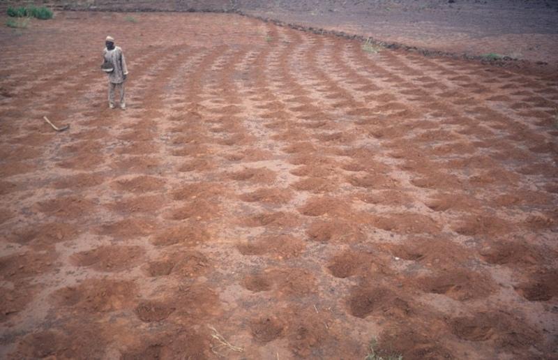
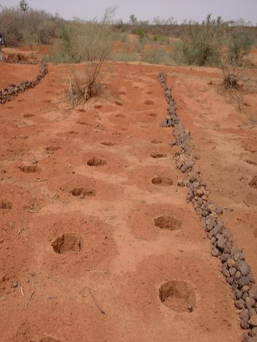
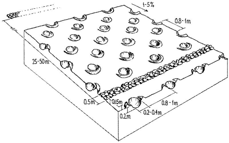
The combination of planting pits (tassa) with stone lines is used for the rehabilitation of degraded, crusted land. This technology is mainly applied in semi-arid areas on sandy/loamy plains, often covered with a hard pan, and with slopes below 5%. These denuded plains are brought into crop cultivation by the combination of tassa and stone lines. Planting pits are holes of 20-30 cm diameter and 20-25 cm depth, spaced about 1 m apart in each direction. The excavated earth is formed into a small ridge downslope of the pit. Manure is added to each pit, but its availability is sometimes a problem. At the start of the rainy season, millet or sorghum is sown in these pits. The overall aim of the system is to capture and hold
rainfall and runoff, and thereby improve water infiltration, while increasing nutrient availability.
Stone lines are small structures, at most three stones wide and sometimes only one stone high. The distance between the lines is a function of the slope and availability of stone. Typically they are sited 25-50 m apart on 2-5% slopes. Stones are usually collected from nearby sites - though sometimes up to 5-10 km away and brought to the fields by donkey carts or lorries (when a project is involved). They are positioned manually, along the contour. Stone lines are intended to slow down runoff. They thereby increase the rate of infiltration, while simultaneously protecting the planting pits from sedimentation.
Often grass establishes between the stones, which helps increase infiltration further and accelerates the accumulation of fertile sediment. Wind-blown particles may also build up along the stone lines due to a local reduction in wind velocity. The accumulation of sediment along the stone lines in turn favours water infiltration on the upslope side. This then improves plant growth, which further enhances the effect of the system. Construction does not require heavy machinery (unless the stones need to be brought from afar by lorry).
The technique is therefore favourable to spontaneous adoption. Stone lines may need to be repaired annually, especially if heavy rains have occurred. Manure is placed every second (or third) year into the previously dug pits and sand is removed annually: normally the highest plant production is during the second year after manure application.
2.3 技术照片
媒体库
2.5 已应用该技术的、本评估所涵盖的国家/地区/地点
国家:
尼日尔
区域/州/省:
Niger, Tahoua
具体说明该技术的分布:
- 均匀地分布在一个区域
如果技术均匀分布在一个区域,则指定覆盖的区域(单位为平方千米):
40.0
注释:
Total area covered by the SLM Technology is 40 km2.
2.7 技术介绍
详细说明该技术是如何引入的:
- 通过项目/外部干预
3. SLM技术的分类
3.1 该技术的主要目的
- 减少、预防、恢复土地退化
3.2 应用该技术的当前土地利用类型

农田
- 一年一作
年作 - 具体指明作物:
- 谷类 - 小米
- 谷类 - 高粱
- 豆科牧草和豆类 - 豌豆
注释:
major food crop: Millet and sorghum
Major land use problems (compiler’s opinion): Soil fertility decline is the basic problem: this is due to degradation and nutrient mining. Loss of limited rainwater by runoff and loss of soil cover result in low crop production and food insufficiency. This occurs in combination with lack of pasture, resulting in shortage of manure.
3.4 供水
该技术所应用土地的供水:
- 雨养
3.5 该技术所属的SLM组
- 集水
- 灌溉管理(包括供水、排水)
3.6 包含该技术的可持续土地管理措施

农艺措施
- A7:其它

结构措施
- S11:其它
注释:
Specification of other agronomic measures: Manure application (supplementary)
Specification of other structural measures: stone lines, planting pits
Type of agronomic measures: manure / compost / residues
3.7 该技术强调的主要土地退化类型

土壤水蚀
- Wt:表土流失/地表侵蚀

土壤风蚀
- Et:表土流失

化学性土壤退化
- Cn:肥力下降和有机质含量下降(非侵蚀所致)

物理性土壤退化
- Pc:压实
- Pk:熟化和结壳
注释:
Main type of degradation addressed: Wt: loss of topsoil / surface erosion, Et: loss of topsoil, Cn: fertility decline and reduced organic matter content, Pc: compaction, Pk: sealing and crusting
3.8 防止、减少或恢复土地退化
具体数量名该技术与土地退化有关的目标:
- 修复/恢复严重退化的土地
4. 技术规范、实施活动、投入和成本
4.1 该技术的技术图纸
技术规范(与技术图纸相关):
Planting pits (tassa) capture rainfall runoff for cultivation of annual crops, and the stone lines - spaced at 25-50 metres apart - help hold back moisture and eroded soil.
Technical knowledge required for field staff / advisors: moderate
Technical knowledge required for land users: low
Main technical functions: increase in organic matter, increase of infiltration, increase / maintain water stored in soil, water harvesting / increase water supply, increase in soil fertility, increases natural regeneration of trees
Secondary technical functions: reduction of slope length, improvement of ground cover, improvement of soil structure
Manure / compost / residues
Quantity/ density: 2.5 t/ha
Structural measure: stone lines
Spacing between structures (m): 25-50planting pits
Structural measure: planting pits
Vertical interval between structures (m): 1
Spacing between structures (m): 1
Depth of ditches/pits/dams (m): 0.2-0.25
Width of ditches/pits/dams (m): 0.2-0.3
Slope (which determines the spacing indicated above): <5%
作者:
Mats Gurtner
4.2 有关投入和成本计算的一般信息
具体说明成本计算所用货币:
- 美元
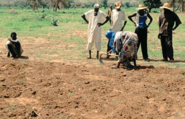
4.3 技术建立活动
| 活动 | 时间(季度) | |
|---|---|---|
| 1. | Digging pits (tassa): the excavated earth | dry season (November to May) |
| 2. | Digging out stones from nearby sites | dry season (November to May) |
| 3. | Transporting stones | dry season (November to May) |
| 4. | Aligning the stones along the contour with the help of a ‘water tube | dry season (November to May) |
4.4 技术建立所需要的费用和投入
| 对投入进行具体说明 | 单位 | 数量 | 单位成本 | 每项投入的总成本 | 土地使用者承担的成本% | |
|---|---|---|---|---|---|---|
| 劳动力 | Digging tassa | persons/day/ha | 100.0 | 1.5 | 150.0 | 100.0 |
| 劳动力 | Building stone lines | persons/day/ha | 26.666 | 1.5 | 40.0 | 100.0 |
| 设备 | Tools for tassa | ha | 1.0 | 5.0 | 5.0 | 100.0 |
| 设备 | Tools for stone lines | ha | 1.0 | 5.0 | 5.0 | 75.0 |
| 肥料和杀菌剂 | Compost/manure | ha | 1.0 | 5.0 | 5.0 | 100.0 |
| 其它 | Transporting stones with lorri | ha | 1.0 | 40.0 | 40.0 | |
| 技术建立所需总成本 | 245.0 | |||||
| 技术建立总成本,美元 | 245.0 | |||||
注释:
Duration of establishment phase: 12 month(s)
4.5 维护/经常性活动
| 活动 | 时间/频率 | |
|---|---|---|
| 1. | Manuring the pits with approx 250 g per pit | dry season (November to May) / initial establishment |
| 2. | Manuring the pits with about 250 g per pit (2.5 t/ha) | October/November or March-May / every second year |
| 3. | Removing sand from the tassa | March-May/annual |
| 4. | Check and repair stone lines | annually and after heavy rains. |
4.6 维护/经常性活动所需要的费用和投入(每年)
| 对投入进行具体说明 | 单位 | 数量 | 单位成本 | 每项投入的总成本 | 土地使用者承担的成本% | |
|---|---|---|---|---|---|---|
| 劳动力 | Labour | persons/day/ha | 21.0 | 1.5 | 31.5 | 100.0 |
| 设备 | Tools for tassa | ha | 1.0 | 1.0 | 1.0 | 100.0 |
| 肥料和杀菌剂 | Compost/manure | ha | 1.0 | 2.5 | 2.5 | 100.0 |
| 技术维护所需总成本 | 35.0 | |||||
| 技术维护总成本,美元 | 35.0 | |||||
注释:
Machinery/ tools: hoe, pick-axe, shovel, donkey cart, (lorries)
The costs are based on 300 m of stone lines per hectare (on a 3-4% slope). Maintenance costs refer to removing sand from the pits from the second year onwards, and to the application of manure every second year (costs are spread on an annual basis). If applicable, costs for transporting the manure need to be added. The general assumption in these calculations is that adequate manure is readily available close by. The availability of stones is the main factor in determining costs - though labour availability can affect prices also. If stones are not available in the field or nearby (from where they can be transported by donkey cart), they have to be carried by lorries, which is much more expensive. The costs here refer to fuel costs only, paid by a project: they do not include depreciation of lorries.
5. 自然和人文环境
5.1 气候
年降雨量
- < 250毫米
- 251-500毫米
- 501-750毫米
- 751-1,000毫米
- 1,001-1,500毫米
- 1,501-2,000毫米
- 2,001-3,000毫米
- 3,001-4,000毫米
- > 4,000毫米
指定年平均降雨量(若已知),单位为mm:
390.00
农业气候带
- 半干旱
5.2 地形
平均坡度:
- 水平(0-2%)
- 缓降(3-5%)
- 平缓(6-10%)
- 滚坡(11-15%)
- 崎岖(16-30%)
- 陡峭(31-60%)
- 非常陡峭(>60%)
地形:
- 高原/平原
- 山脊
- 山坡
- 山地斜坡
- 麓坡
- 谷底
垂直分布带:
- 0-100 m a.s.l.
- 101-500 m a.s.l.
- 501-1,000 m a.s.l.
- 1,001-1,500 m a.s.l.
- 1,501-2,000 m a.s.l.
- 2,001-2,500 m a.s.l.
- 2,501-3,000 m a.s.l.
- 3,001-4,000 m a.s.l.
- > 4,000 m a.s.l.
5.3 土壤
平均土层深度:
- 非常浅(0-20厘米)
- 浅(21-50厘米)
- 中等深度(51-80厘米)
- 深(81-120厘米)
- 非常深(> 120厘米)
土壤质地(表土):
- 粗粒/轻(砂质)
- 中粒(壤土、粉土)
表土有机质:
- 低(<1%)
如有可能,附上完整的土壤描述或具体说明可用的信息,例如土壤类型、土壤酸碱度、阳离子交换能力、氮、盐度等。:
Soil depth on average: Also deep
Soil fertility is low - very low
Soil drainage / infiltration is good, though infiltration is low where there is a crust
5.6 应用该技术的土地使用者的特征
生产系统的市场定位:
- 生计(自给)
- 混合(生计/商业)
非农收入:
- > 收入的50%
机械化水平:
- 手工作业
- 畜力牵引
说明土地使用者的其他有关特征:
Off-farm income specification: remittances from out-migration of labour, commerce and crafts
5.7 应用该技术的土地使用者使用的平均土地面积
- < 0.5 公顷
- 0.5-1 公顷
- 1-2 公顷
- 2-5公顷
- 5-15公顷
- 15-50公顷
- 50-100公顷
- 100-500公顷
- 500-1,000公顷
- 1,000-10,000公顷
- > 10,000公顷
5.8 土地所有权、土地使用权和水使用权
土地所有权:
- 个人,有命名
土地使用权:
- 个人
6. 影响和结论性说明
6.1 该技术的现场影响
社会经济效应
生产
作物生产
收入和成本
农业收入
工作量
其它社会经济效应
input contstraints
社会文化影响
社区机构
注释/具体说明:
Through mutual aid in technology implementation
SLM/土地退化知识
冲突缓解
注释/具体说明:
Land use rights conflicts of rehabilitated land and conflicts between farmers and pastoralists, because pasture land is being turned into cultivated fields
生态影响
水循环/径流
多余水的排放
土壤
土壤水分
土壤流失
土壤有机物/地下C
其它生态影响
soil fertility
long-term soil cover
6.2 该技术的场外影响已经显现
下游洪水
下游淤积
6.4 成本效益分析
技术收益与技术建立成本相比如何(从土地使用者的角度看)?
短期回报:
积极
长期回报:
非常积极
技术收益与技术维护成本/经常性成本相比如何(从土地使用者的角度看)?
短期回报:
积极
长期回报:
非常积极
6.5 技术采用
注释:
There is a moderate trend towards spontaneous adoption of the Technology
Comments on adoption trend: There is moderate growing spontaneous adoption (for rehabilitation of the plains), but there are no estimates available regarding the extent.
6.7 该技术的优点/长处/机会
| 编制者或其他关键资源人员认为的长处/优势/机会 |
|---|
|
Simple technology, individually applicable in the dry season, requiring only very little training/knowledge and no special equipment. |
| Making best use of manure, which is a limiting resource. |
| Increase in agricultural production. |
| Rehabilitation of degraded and denuded land: bringing back into production formerly uncultivated land; extension of farm land to the plateaus. |
6.8 技术的弱点/缺点/风险及其克服方法
| 编制者或其他关键资源人员认为的弱点/缺点/风险 | 如何克服它们? |
|---|---|
| Labour demanding technology for implementation and maintenance | Mechanisation of tasks: transportation of stones and manure. However, this would raise the cost. |
| Instability of planting pits in loose soil, increased erosion on steeper slopes and with heavier rains |
Avoid loose sandy soils and steep slopes. |
|
The effectiveness can be compromised if the various geo-morphological units (plateaus, slopes) are not treated simultaneously |
Catchment area approach if downstream flooding is an issue. |
|
Possibility of land use conflicts concerning rehabilitated land, in particular with pastoralists |
Better coordination/consultation before implementing the technology in an area. |
| Implementation constraint: availability of manure and/or stones and transporting manure/stones to the plateaus and slopes | Subsidise transport means (or supply donkey carts) or/and apply stone lines only in areas where there are stones available close to the fields. |
7. 参考和链接
7.1 信息的方法/来源
7.2 参考可用出版物
标题、作者、年份、ISBN:
Bety A, Boubacar A, Frölich W, Garba A, Kriegl M, Mabrouk A, Noufou O, Thienel M and Wincker H: Gestion durable desressources naturelles. Leçons tirées du savoir des paysans de l’Adar. Ministère de l’agriculture et de l’élevage, Niamey, 142 pp.. 19
标题、作者、年份、ISBN:
Hassane A, Martin Pand Reij C:Water harvesting, land rehabilitation and household food security in Niger: IFAD’s Soil and Water Conservation Project in IllelaDistrict. IFAD, Rome, 51 pp.. 2000.
标题、作者、年份、ISBN:
Mabrouk A, Tielkes E and Kriegl M: Conservation des eaux et des sols: Leçons des connaissances traditionnelles de la région de Tahoua, Niger. In: Renard, G., Neef, A,. Becker, K. and Von Oppen, M. (eds). de la région de Tahoua, Niger. 1998.
标题、作者、年份、ISBN:
Mabrouk A, Tielkes E and Kriegl M: Conservation des eaux et des sols: Leçons des connaissances traditionnelles de la région de Tahoua, Niger. In: Renard, G., Neef, A,. Becker, K. and Von Oppen, M. (eds). de la région de Tahoua, Niger. 1998.
标题、作者、年份、ISBN:
Mabrouk A, Tielkes E and Kriegl M: Conservation des eaux et des sols: Leçons des connaissances traditionnelles de la région de Tahoua, Niger. In: Renard, G., Neef, A,. Becker, K. and Von Oppen, M. (eds). de la région de Tahoua, Niger. 1998.
标题、作者、年份、ISBN:
Mabrouk A, Tielkes E and Kriegl M: Conservation des eaux et des sols: Leçons des connaissances traditionnelles de la région de Tahoua, Niger. In: Renard, G., Neef, A,. Becker, K. and Von Oppen, M. (eds). de la région de Tahoua, Niger. 1998.
标题、作者、年份、ISBN:
Mabrouk A, Tielkes E and Kriegl M: Conservation des eaux et des sols: Leçons des connaissances traditionnelles de la région de Tahoua, Niger. In: Renard, G., Neef, A,. Becker, K. and Von Oppen, M. (eds). de la région de Tahoua, Niger. 1998.
标题、作者、年份、ISBN:
Mabrouk A, Tielkes E and Kriegl M: Conservation des eaux et des sols: Leçons des connaissances traditionnelles de la région de Tahoua, Niger. In: Renard, G., Neef, A,. Becker, K. and Von Oppen, M. (eds). de la région de Tahoua, Niger. 1998.
标题、作者、年份、ISBN:
Mabrouk A, Tielkes E and Kriegl M: Conservation des eaux et des sols: Leçons des connaissances traditionnelles de la région de Tahoua, Niger. In: Renard, G., Neef, A,. Becker, K. and Von Oppen, M. (eds). de la région de Tahoua, Niger. 1998.
标题、作者、年份、ISBN:
Mabrouk A, Tielkes E and Kriegl M: Conservation des eaux et des sols: Leçons des connaissances traditionnelles de la région de Tahoua, Niger. In: Renard, G., Neef, A,. Becker, K. and Von Oppen, M. (eds). de la région de Tahoua, Niger. 1998.
链接和模块
全部展开 全部收起链接
Approche participative de réhabilitation des terres individuelles et … [尼日尔 ]
Planification et gestion des terres individuelles et villageoises sur la base d’une participation des usagers ; promotion simultanée des activités des femmes.
- 编制者: Eric Tielkes
模块
无模块