Cascading Rock Irrigation Channel [塔吉克斯坦]
- 创建:
- 更新:
- 编制者: Davlatbek Davlatov
- 编辑者: –
- 审查者: Alexandra Gavilano, David Streiff, Joana Eichenberger
Boloi Dasht (Tajik)
technologies_1454 - 塔吉克斯坦
查看章节
全部展开 全部收起1. 一般信息
1.2 参与该技术评估和文件编制的资源人员和机构的联系方式
SLM专业人员:
有助于对技术进行记录/评估的项目名称(如相关)
Pilot Program for Climate Resilience, Tajikistan (WB / PPCR)有助于对技术进行记录/评估的机构名称(如相关)
CAMP - Central Asian Mountain Partnership (CAMP - Central Asian Mountain Partnership) - 吉尔吉斯斯坦1.3 关于使用通过WOCAT记录的数据的条件
编制者和关键资源人员接受有关使用通过WOCAT记录数据的条件。:
是
2. SLM技术的说明
2.1 技术简介
技术定义:
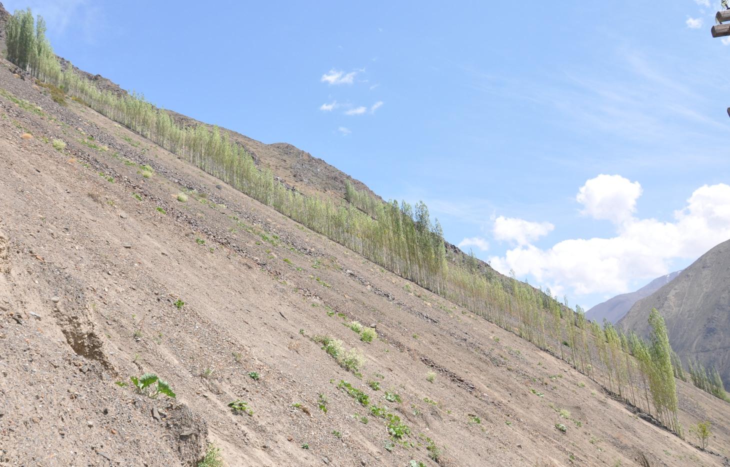
A cascading rock irrigation channel lined with fast growing poplar trees, constructed on rocky slopes to channel water runoff from the high mountains for human use at the valley floor.
2.2 技术的详细说明
说明:
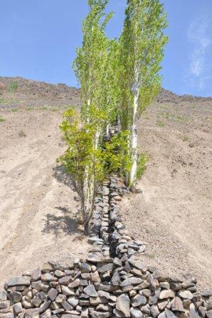
A one metre wide, 300m long, irrigation channel constructed of stones, that is built into the steep slope of a mountain gorge. The channel is 0.5m deep and is lined with poplar trees that help stabilise the structure. The water runs down the channel from the top mountains, with water splashing onto the poplar trees. At the foot of the channel the water is used to irrigated cultivated land and provide drinking water.
Purpose of the Technology: The main purpose of the cascading rock irrigation structure is to capture surface water run-off from the top of the mountain and channel it to where it can be utilised for human use such as drinking water, sanitation, and irrigation. The uneven surface of the rock channel slows the pace of the water thus preventing scouring at the foot of the channel. The channel also provides a suitable environment for the cultivation of poplar trees which in turn can help reduce water and wind erosion on the slopes, thus preventing rock and debris movement down onto the cultivated lands on the valley floor.
Establishment / maintenance activities and inputs: The channel is dug perpendicular to the steep slope and lined with stones gathered from the mountainous slopes. This activity is labour intensive, but can be more efficient with the use of donkeys. The stones are placed upon/on top of each other in the base of the channel, and used to line the sides of the channel to retain the water. The soil along the edge of the channel is cleared of debris and stone until it is suitable for the planting of poplar cuttings. The cutting are supplemented with organic fertiliser. The channel is financed by the land owner, with voluntary support from the community.
Natural / human environment: The cascading rock irrigation channel is located in a remote steep mountainous gorge where there is a shortage of land for cultivation. Water is in short supply, especially during the hot summer months. Subsequently the inhabitants have a high dependency on irrigated water from the top of the mountain range. The majority of the residents have a semi-subsistence living and are highly reliant upon the cultivated land where they grow a range of crops (e.g. wheat, potatoes. etc), fruits (e.g. apricots) and poplar trees for selling and construction purposes.
2.3 技术照片
媒体库
2.5 已应用该技术的、本评估所涵盖的国家/地区/地点
国家:
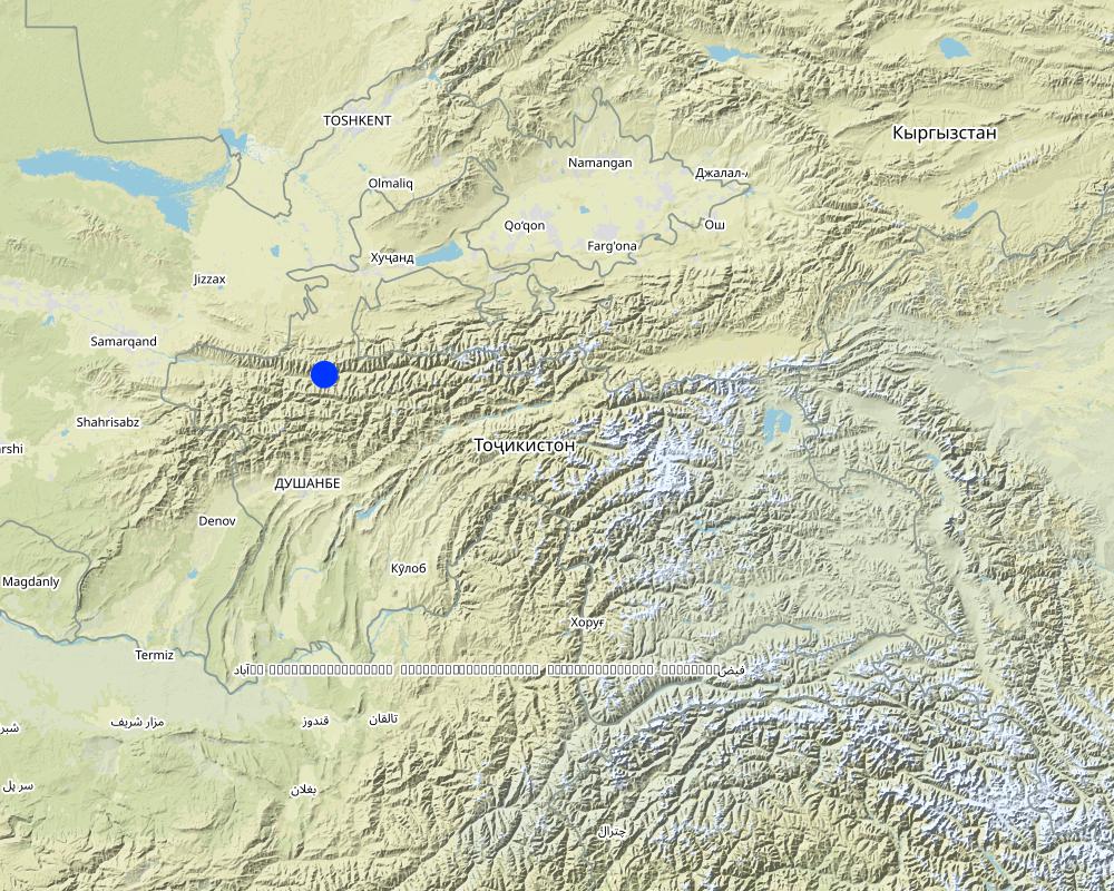
塔吉克斯坦
区域/州/省:
Sogd region
有关地点的进一步说明:
Ayni
具体说明该技术的分布:
- 均匀地分布在一个区域
如果不知道精确的区域,请注明大致覆盖的区域:
- < 0.1 平方千米(10 公顷)
注释:
Long and narrow geographical areas were chosen for implementation of the technology. The technology was replicated ten times in this community area.
Map
×2.6 实施日期
如果不知道确切的年份,请说明大概的日期:
- 10-50年前
2.7 技术介绍
详细说明该技术是如何引入的:
- 通过土地使用者的创新
注释(项目类型等):
The technology was constructed in 1992 and 1997 based upon ideas generated from the local inhabitants.
3. SLM技术的分类
3.1 该技术的主要目的
- 减少、预防、恢复土地退化
- improved access to water
3.2 应用该技术的当前土地利用类型

农田
- 一年一作
- 乔木与灌木的种植
年作 - 具体指明作物:
- 谷类 - 小麦(冬季)
- 根/块茎作物 - 土豆
乔木和灌木种植 - 指定作物:
- 核果(桃、杏、樱桃、李子等)
每年的生长季节数:
- 1

森林/林地
- (半天然)天然森林/林地
- 植树造林
植树造林:说明树种的起源和组成:
- 单一栽培的本地品种
产品和服务:
- 自然灾害防护
- construction
其它
具体说明:
Wasteland: The mountain slopes are mainly devoid of vegetation.
注释:
Major land use problems (compiler’s opinion): Water and wind erosion, rockfalls and debris movement.
Major land use problems (land users’ perception): Debris movement due to excessive rains damaging crops and infrastructure.
Selective felling of (semi-) natural forests: Infrequent felling of poplars.
Forest products and services: timber, protection against natural hazards
Other forest products and services: construction
Future (final) land use (after implementation of SLM Technology): Forests / woodlands: Fp: Plantations, afforestations
Constraints of wastelands / deserts / glaciers / swamps
3.3 由于技术的实施,土地使用是否发生了变化?
农田
- 一年一作
- 乔木与灌木的种植
年作 - 具体指明作物:
- 谷类 - 小麦(春季)
- 根/块茎作物 - 土豆
乔木和灌木种植 - 指定作物:
- 核果(桃、杏、樱桃、李子等)
森林/林地
- 植树造林
3.4 供水
该技术所应用土地的供水:
- 雨养
注释:
Number of growing seasons per year:
1
Specify:
Longest growing period in days: 180Longest growing period from month to month: March-October
3.5 该技术所属的SLM组
- 横坡措施
- 灌溉管理(包括供水、排水)
- 引水和排水
3.6 包含该技术的可持续土地管理措施

农艺措施
- A1:植被和土壤覆盖层

植物措施
- V1:乔木和灌木覆盖层

结构措施
- S3:分级沟渠、渠道、水道
注释:
Main measures: vegetative measures, structural measures
Type of vegetative measures: aligned: -linear
3.7 该技术强调的主要土地退化类型

土壤水蚀
- Wg:冲沟侵蚀/沟蚀
- Wm:块体运动/滑坡

土壤风蚀
- Ed:风蚀风积
注释:
Main type of degradation addressed: Wm: mass movements / landslides
Secondary types of degradation addressed: Wg: gully erosion / gullying, Ed: deflation and deposition
Main causes of degradation: deforestation / removal of natural vegetation (incl. forest fires) (Removal of forest vegetation many years before.), Heavy / extreme rainfall (intensity/amounts) (Extreme events lead to debris movement covering fertile lands.)
Secondary causes of degradation: war and conflicts (Lack of natural resources during civil war led to the cutting of many of the trees preventing slope movement.)
3.8 防止、减少或恢复土地退化
具体数量名该技术与土地退化有关的目标:
- 减少土地退化
4. 技术规范、实施活动、投入和成本
4.1 该技术的技术图纸
技术规范(与技术图纸相关):
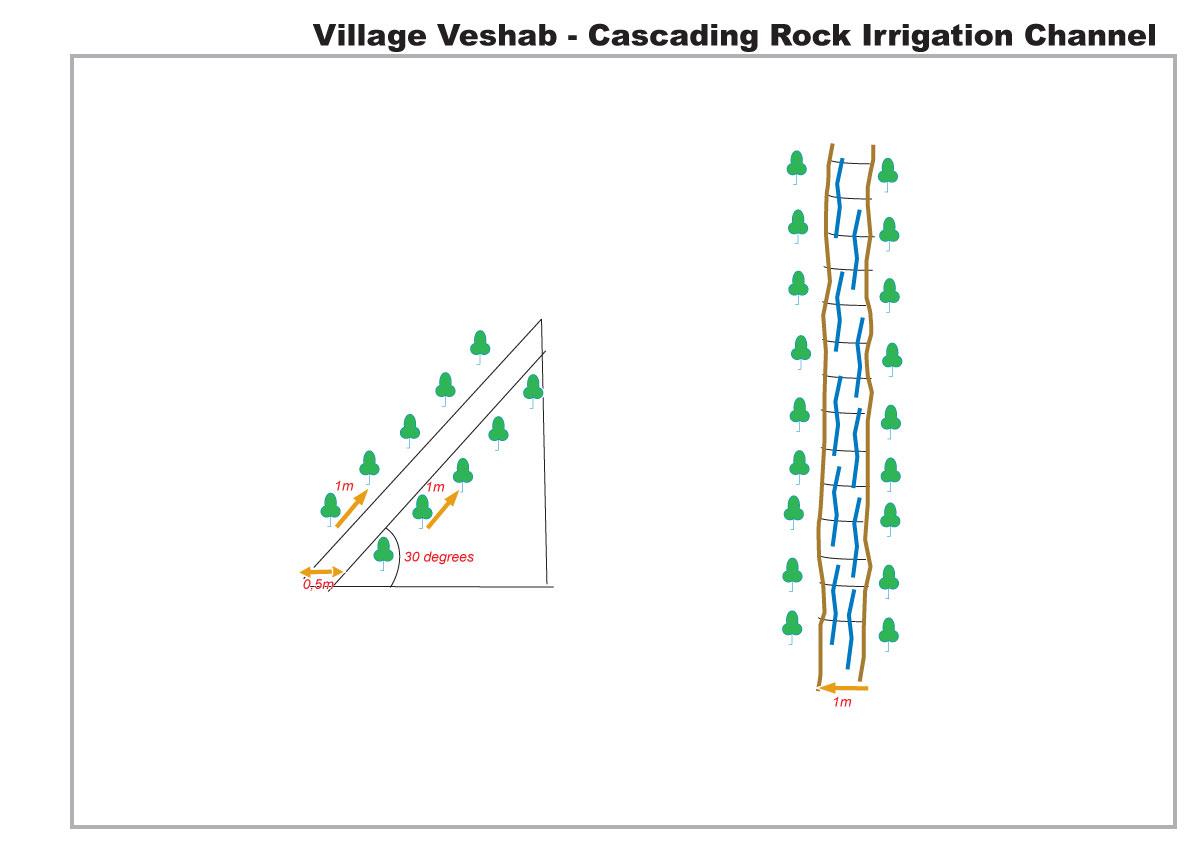
The drawing shows in plan and profile the cascading rock channel. The slope of the mountain is 30 degrees, a one metre wide channel, 0.5 m deep, is dug into the slope. The channel is lined with stones. The soil either side of the channel is cleared of rocks, and poplar branches are planted at 1m intervals lining the channel.
Location: Veshab Boloi Dasht. Ayni Sughd Region Tajikistan
Date: 2011-05-04
Technical knowledge required for land users: moderate (An understanding of how to build the basic structure without it collapsing and able to meet the discharge capacity of the water.)
Main technical functions: control of concentrated runoff: drain / divert, water harvesting / increase water supply, Prevent off site damage to cultivated land at the foot of the slope.
Secondary technical functions: Stabilisation of soil along the channel.
Aligned: -linear
Vegetative material: T : trees / shrubs
Number of plants per (ha): 600
Vertical interval within rows / strips / blocks (m): 1
Width within rows / strips / blocks (m): 1
Trees/ shrubs species: Poplars (safedor) are planted in vertical rows, 1m apart, on both sides of the 1m wide channel.
Slope (which determines the spacing indicated above): 30.00%
Waterway
Depth of ditches/pits/dams (m): 0.5
Width of ditches/pits/dams (m): 1
Length of ditches/pits/dams (m): 300
Construction material (stone): local stones and rocks
Slope (which determines the spacing indicated above): 30%
Vegetation is used for stabilisation of structures.
作者:
Davlatov Davlatbek, Dushanbe City,Rudaki str.131,fl.19
4.2 有关投入和成本计算的一般信息
具体说明成本和投入是如何计算的:
- 每个技术单元
其它/国家货币(具体说明):
Somoni
如相关,注明美元与当地货币的汇率(例如1美元=79.9巴西雷亚尔):1美元=:
4.5
注明雇用劳工的每日平均工资成本:
5.50
4.3 技术建立活动
| 活动 | 时间(季度) | |
|---|---|---|
| 1. | Planting Poplars | Spring, March |
| 2. | Composting | spring |
| 3. | Construction of rock irrigation channel | spring |
4.4 技术建立所需要的费用和投入
| 对投入进行具体说明 | 单位 | 数量 | 单位成本 | 每项投入的总成本 | 土地使用者承担的成本% | |
|---|---|---|---|---|---|---|
| 劳动力 | Planting Poplars | Persons/day | 10.0 | 25.0 | 250.0 | 100.0 |
| 劳动力 | Construction of rock irrigation channel | Persons/day | 60.0 | 25.0 | 1500.0 | 100.0 |
| 设备 | Tools | Pieces | 3.0 | 20.0 | 60.0 | 100.0 |
| 设备 | Donkey | Donkey/day | 20.0 | 22.5 | 450.0 | 100.0 |
| 植物材料 | Seedlings | Unit | 1.0 | 266.0 | 266.0 | 100.0 |
| 肥料和杀菌剂 | Composte | per tree | 250.0 | 1.0 | 250.0 | 100.0 |
| 施工材料 | Stone | tons | 50.0 | 20.0 | 1000.0 | 100.0 |
| 技术建立所需总成本 | 3776.0 | |||||
| 技术建立总成本,美元 | 839.11 | |||||
注释:
Duration of establishment phase: 1 month(s)
4.5 维护/经常性活动
| 活动 | 时间/频率 | |
|---|---|---|
| 1. | tree tending | every year |
| 2. | Maintenance of channel | Spring |
4.6 维护/经常性活动所需要的费用和投入(每年)
| 对投入进行具体说明 | 单位 | 数量 | 单位成本 | 每项投入的总成本 | 土地使用者承担的成本% | |
|---|---|---|---|---|---|---|
| 劳动力 | Tree tending | Persons/day | 7.0 | 25.0 | 175.0 | 100.0 |
| 劳动力 | Maintenance of channel | Persons/day | 10.0 | 25.0 | 250.0 | 100.0 |
| 技术维护所需总成本 | 425.0 | |||||
| 技术维护总成本,美元 | 94.44 | |||||
注释:
The indicative cost of the technology was calculated based on 2010 prices.
4.7 影响成本的最重要因素
描述影响成本的最决定性因素:
There was no real cost in construction of the rock irrigation channel. All labour, animal traction and materials were sourced locally for no cost, poplar seedlings are cuttings from local poplars, and organic compost for the trees was collected from local livestock.
5. 自然和人文环境
5.1 气候
年降雨量
- < 250毫米
- 251-500毫米
- 501-750毫米
- 751-1,000毫米
- 1,001-1,500毫米
- 1,501-2,000毫米
- 2,001-3,000毫米
- 3,001-4,000毫米
- > 4,000毫米
有关降雨的规范/注释:
Heavy Spring and Autumn Rain
农业气候带
- 半干旱
Thermal climate class: temperate. 4 months of snowing during the winter period.
5.2 地形
平均坡度:
- 水平(0-2%)
- 缓降(3-5%)
- 平缓(6-10%)
- 滚坡(11-15%)
- 崎岖(16-30%)
- 陡峭(31-60%)
- 非常陡峭(>60%)
地形:
- 高原/平原
- 山脊
- 山坡
- 山地斜坡
- 麓坡
- 谷底
垂直分布带:
- 0-100 m a.s.l.
- 101-500 m a.s.l.
- 501-1,000 m a.s.l.
- 1,001-1,500 m a.s.l.
- 1,501-2,000 m a.s.l.
- 2,001-2,500 m a.s.l.
- 2,501-3,000 m a.s.l.
- 3,001-4,000 m a.s.l.
- > 4,000 m a.s.l.
关于地形的注释和进一步规范:
Altitudinal zone: This area is located at 1500m
5.3 土壤
平均土层深度:
- 非常浅(0-20厘米)
- 浅(21-50厘米)
- 中等深度(51-80厘米)
- 深(81-120厘米)
- 非常深(> 120厘米)
土壤质地(表土):
- 粗粒/轻(砂质)
表土有机质:
- 低(<1%)
如有可能,附上完整的土壤描述或具体说明可用的信息,例如土壤类型、土壤酸碱度、阳离子交换能力、氮、盐度等。:
Soil texture is rocky, shale.
Soil fertility is very low and nothing is growing on the adjacent slopes.
Soil drainage / infiltration is poor
Soil water storage capacity is very low.
5.4 水资源可用性和质量
地下水位表:
> 50米
地表水的可用性:
匮乏/没有
水质(未处理):
良好饮用水
5.5 生物多样性
物种多样性:
- 低
关于生物多样性的注释和进一步规范:
No natural propogation/reproduction on the slope and slow growth rate without irrigation.
5.6 应用该技术的土地使用者的特征
生产系统的市场定位:
- 生计(自给)
- 混合(生计/商业)
非农收入:
- > 收入的50%
相对财富水平:
- 平均水平
个人或集体:
- 团体/社区
性别:
- 女人
- 男人
说明土地使用者的其他有关特征:
Land users applying the Technology are mainly common / average land users
Population density: < 10 persons/km2
Annual population growth: 1% - 2%
100% of the land users are average wealthy and own 100% of the land.
Off-farm income specification: Some of the incomes come from driving, teaching etc
Market orientation of production system: Poplars are used for personal construction projects but can be sold for $300 per tree.
5.7 应用该技术的土地使用者使用的平均土地面积
- < 0.5 公顷
- 0.5-1 公顷
- 1-2 公顷
- 2-5公顷
- 5-15公顷
- 15-50公顷
- 50-100公顷
- 100-500公顷
- 500-1,000公顷
- 1,000-10,000公顷
- > 10,000公顷
这被认为是小规模、中规模还是大规模的(参照当地实际情况)?:
- 小规模的
5.8 土地所有权、土地使用权和水使用权
土地所有权:
- 州
土地使用权:
- 社区(有组织)
用水权:
- 社区(有组织)
5.9 进入服务和基础设施的通道
健康:
- 贫瘠
- 适度的
- 好
教育:
- 贫瘠
- 适度的
- 好
技术援助:
- 贫瘠
- 适度的
- 好
就业(例如非农):
- 贫瘠
- 适度的
- 好
市场:
- 贫瘠
- 适度的
- 好
能源:
- 贫瘠
- 适度的
- 好
道路和交通:
- 贫瘠
- 适度的
- 好
饮用水和卫生设施:
- 贫瘠
- 适度的
- 好
金融服务:
- 贫瘠
- 适度的
- 好
6. 影响和结论性说明
6.1 该技术的现场影响
社会经济效应
生产
木材生产
生产区域
水资源可用性和质量
饮用水的可用性
家畜用水的可用性
收入和成本
农业收入
社会文化影响
食品安全/自给自足
SLM/土地退化知识
Livelihood and human well-being
注释/具体说明:
This includes wood for construction, improved water supply for irrigation and improved water quality for drinking and sanitation.
生态影响
水循环/径流
水量
水质
水的回收/收集
地表径流
土壤
土壤流失
减少气候和灾害风险
滑坡/泥石流
风速
6.2 该技术的场外影响已经显现
水资源可用性
风力搬运沉积物
对邻近农田的破坏
对公共/私人基础设施的破坏
6.3 技术对渐变气候以及与气候相关的极端情况/灾害的暴露和敏感性(土地使用者认为的极端情况/灾害)
渐变气候
渐变气候
| 季节 | 增加或减少 | 该技术是如何应对的? | |
|---|---|---|---|
| 年温度 | 增加 | 好 |
气候有关的极端情况(灾害)
气象灾害
| 该技术是如何应对的? | |
|---|---|
| 局地暴雨 | 好 |
| 局地风暴 | 好 |
气候灾害
| 该技术是如何应对的? | |
|---|---|
| 干旱 | 不好 |
水文灾害
| 该技术是如何应对的? | |
|---|---|
| 比较和缓的(河道)洪水 | 不好 |
其他气候相关的后果
其他气候相关的后果
| 该技术是如何应对的? | |
|---|---|
| mass soil movement | 不好 |
6.4 成本效益分析
技术收益与技术建立成本相比如何(从土地使用者的角度看)?
短期回报:
非常积极
长期回报:
非常积极
技术收益与技术维护成本/经常性成本相比如何(从土地使用者的角度看)?
短期回报:
非常积极
长期回报:
非常积极
注释:
Low initial expense due to inputs easily available.
6.5 技术采用
- 1-10%
如若可行,进行量化(住户数量和/或覆盖面积):
400 households
在所有采用这项技术的人当中,有多少人是自发的,即未获得任何物质奖励/付款?:
- 91-100%
注释:
5% of land user families have adopted the Technology without any external material support
400 land user families have adopted the Technology without any external material support
Comments on spontaneous adoption: Minimal replication in small areas of land, but no replication in recent years. (It appears in this area the implementation of the technology may have been optimised).
There is no trend towards spontaneous adoption of the Technology
6.7 该技术的优点/长处/机会
| 土地使用者眼中的长处/优势/机会 |
|---|
|
Improved livelihoods and the variety and yield of crops. How can they be sustained / enhanced? If the water was not available through the channel then the land would have to be abandoned. |
| The poplar trees provide a good source of secondary income. |
| 编制者或其他关键资源人员认为的长处/优势/机会 |
|---|
|
It reduces soil and wind erosion from the mountain slopes. How can they be sustained / enhanced? Further planting of trees. |
| It reduces rockfalls and debris movement, thus protecting the land down slope that is used for cultivation. |
|
It provides water for irrigation and hence leads to an increase in crops yields and crop diversification down slope of the channel. These crops include wheat, potatoes, onions and some fruit trees mainly apricot. How can they be sustained / enhanced? Pipes form the channel to other areas. |
|
Increased access to clean running water has improved sanitation and hygiene conditions for the inhabitants. How can they be sustained / enhanced? Further training on hygiene and sanitation. |
| The use of uneven rocks slows down the speed of the water in the channel and prevents water erosion at the base of the slope. |
6.8 技术的弱点/缺点/风险及其克服方法
| 土地使用者认为的弱点/缺点/风险 | 如何克服它们? |
|---|---|
| The channel can become severely damaged after a harsh winter. | The rock lining could be cemented in but that would increase the cost, and the trees would not be able to use the water that soaks through the channel. |
| 编制者或其他关键资源人员认为的弱点/缺点/风险 | 如何克服它们? |
|---|---|
| The technology is a major construction activity that needs to be strategically positioned. | The location should be carefully considered with help of specialists. |
7. 参考和链接
7.1 信息的方法/来源
链接和模块
全部展开 全部收起链接
无链接
模块
无模块