Stonelines [肯尼亚]
- 创建:
- 更新:
- 编制者: Paul Kahiga
- 编辑者: –
- 审查者: David Streiff, Alexandra Gavilano
Miraini ya maviga
technologies_1581 - 肯尼亚
查看章节
全部展开 全部收起1. 一般信息
1.2 参与该技术评估和文件编制的资源人员和机构的联系方式
SLM专业人员:
Mwangi Gathenya
JKUAT
肯尼亚
SLM专业人员:
Home Patrick
JKUAT
肯尼亚
SLM专业人员:
Wamuongo Jane
KARI
肯尼亚
SLM专业人员:
Namirembe Sara
ICRAF
肯尼亚
SLM专业人员:
Chege Timothy
JKUAT
肯尼亚
SLM专业人员:
Karanja Andrew
KARI
肯尼亚
有助于对技术进行记录/评估的机构名称(如相关)
International Centre for Research in Agroforestry (ICRAF) - 肯尼亚有助于对技术进行记录/评估的机构名称(如相关)
KARI Headquarters (KARI Headquarters) - 肯尼亚有助于对技术进行记录/评估的机构名称(如相关)
Jomo Kenyatta University (Jomo Kenyatta University) - 肯尼亚1.3 关于使用通过WOCAT记录的数据的条件
编制者和关键资源人员接受有关使用通过WOCAT记录数据的条件。:
是
2. SLM技术的说明
2.1 技术简介
技术定义:
Stonelines are constructed along the contours to slow down the speed of runoff, filter the soil and enhance water infiltration.
2.2 技术的详细说明
说明:
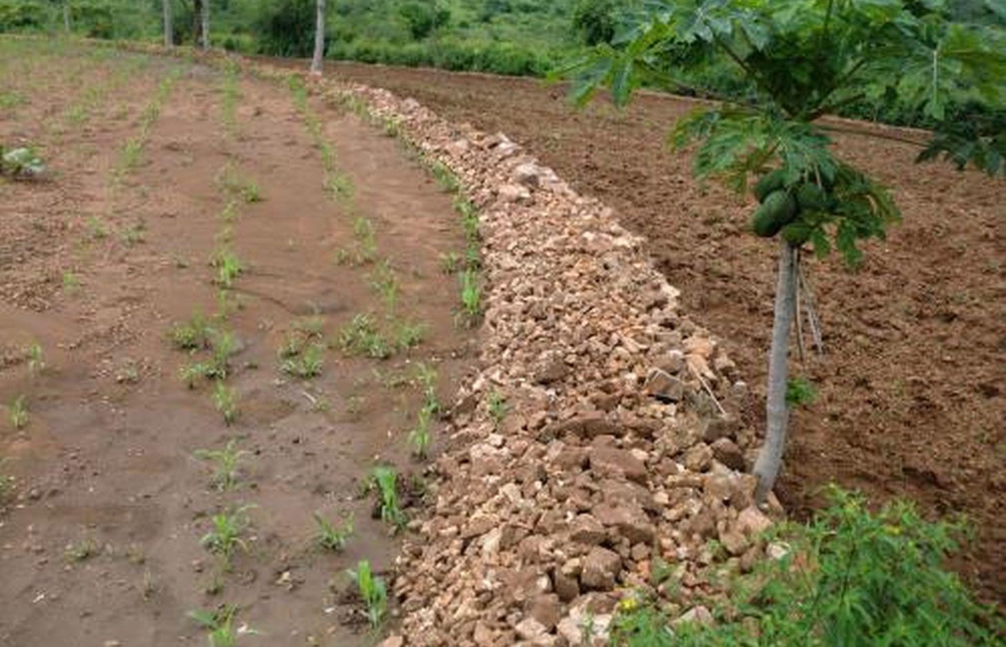
In Kenya stone lines are mostly practiced in areas that receive 200-750 mm of annual rainfall with a spacing of 15-30 m between them. They are particularly common in areas where rocks are readily available, such as Mbeere, Laikipia, Baringo, Mwingi, Kitui and Tharaka. Since the stonelines are permeable they do not pond runoff water but instead, they slow down the speed, filter it and spread the water over the field, thus enhancing water infiltration and reducing soil erosion. They are built in series running along the slope. In addition, the stone barrier blocks and settles down the sediments transported from the upper slopes.
Purpose of the Technology: They are often used to rehabilitate eroded and abandoned land. The advantages of stonelines include; slowing down the runoff thereby increasing infiltration and soil moisture. They also induce a natural process of terracing, reducing erosion and rehabilitation of eroded lands by trapping silt. They are easy to design and construct and since the stone line structure is permeable there is no need for construction of spillways to drain the excess runoff water. When it rains, the soil builds up on the upslope side of the stonelines and over time a natural terrace is formed.
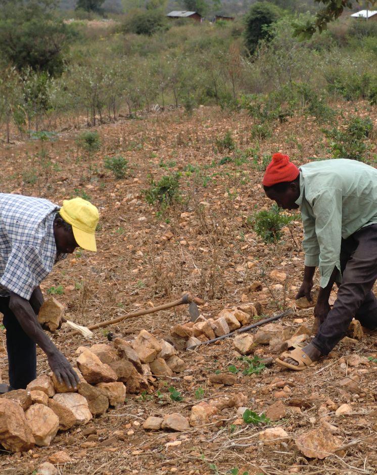
Establishment / maintenance activities and inputs: The stonelines are spaced 15-30 m apart, a shorter distance being used for the steeper slopes. Stonelines are normally suitable on gentle slopes. Slopes above 35% should be avoided. They are established in the following manner: first, the contour line are marked out with the help of a tube level or line levels. In this region here, it is done with the help of the frontline agricultural extension officers. Secondly, a shallow foundation trench is dug across the slope (5-10 cm to 30 cm deep) using basic farm equipments (jembes or hoes). As shown on the above photographs, the larger stones are put on the down slope side of the trench while the smaller stones are used to build the rest of the bund. The smallest stones are used to fill the gaps and increase the heights of the bunds up to the desired level. Farmers plant fruit trees (pawpaws) as show in the photograph above on the upper part. The trees utilises the moisture and rich sediments deposited on the upper part. The stonelines can be reinforced with earth, or crop residues to make them more stable. Maintenance of stonelines is done by repairing the already damaged /fallen stoneline that may have been knocked down or disarranged by livestock or by human beings. In this case animal access needs to be limited and/or the bund should be laid out in a way that allows the animals to pass through.
Natural / human environment: In the lower Mbeere South District where the stoneline technologies is largely practiced, unless there are stones in the individual farms, it might be difficult to import stones from other farms as the exercise can be labor intensive. In this catchment, the Ministry of Agriculture through the front line extension officers has taken a lead role in encouraging farmers to adopt the technology especially the farms which have many stones. Most of the farmers who have implemented this technology in the Lower Mbeere South District learn from the ones who are already practicing through field days or individual initiatives.
2.3 技术照片
媒体库
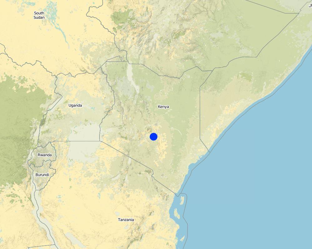
2.5 已应用该技术的、本评估所涵盖的国家/地区/地点
国家:
肯尼亚
区域/州/省:
Eastern Province
有关地点的进一步说明:
Mbeere South District
具体说明该技术的分布:
- 均匀地分布在一个区域
如果不知道精确的区域,请注明大致覆盖的区域:
- < 0.1 平方千米(10 公顷)
注释:
Not many farmers are practicing stonelines, the farmers who are practicing are copying from some successful farmers within their neighborhood. They also corroborate with the local agricultural extension officers from the Ministry of Agriculture (MoA) to show them how to construct the stonelines along the contours.
Map
×2.6 实施日期
如果不知道确切的年份,请说明大概的日期:
- 10-50年前
2.7 技术介绍
详细说明该技术是如何引入的:
- 通过土地使用者的创新
注释(项目类型等):
The land had too many stones which inhibited operations. By removing the stones, the farmer placed them in line along the contour.
3. SLM技术的分类
3.1 该技术的主要目的
- 减少、预防、恢复土地退化
3.2 应用该技术的当前土地利用类型

农田
- 一年一作
- 多年一作(非木材)
- 乔木与灌木的种植
年作 - 具体指明作物:
- 谷物类 - 玉米
- 谷类 - 小米
- 谷类 - 高粱
- 豆科牧草和豆类 - 豌豆
乔木和灌木种植 - 指定作物:
- 芒果、山竹果、番石榴
- 仁果类(苹果、梨子、柑橘等)
每年的生长季节数:
- 2
具体说明:
Longest growing period in days: 90 Longest growing period from month to month: March-May Second longest growing period in days: 90 Second longest growing period from month to month: October - December
注释:
Major crop: Sorghum, maize, mangoes, pawpaws, miraa, millet, cowpeas
Major land use problems (compiler’s opinion): Limited cultivation land due to hindrances that are brought about by the scattered stones on the land's surface.
Major land use problems (land users’ perception): Soil erosion because of lack of soil and water conservation structures that leads to low land productivity.
Future (final) land use (after implementation of SLM Technology): Cropland: Ca: Annual cropping
3.3 由于技术的实施,土地使用是否发生了变化?
由于技术的实施,土地使用是否发生了变化?:
- 是(请在技术实施前填写以下有关土地利用的问题)
农田
- 乔木与灌木的种植
3.4 供水
该技术所应用土地的供水:
- 雨养
3.5 该技术所属的SLM组
- 引水和排水
3.6 包含该技术的可持续土地管理措施

结构措施
- S2:堤、岸
3.7 该技术强调的主要土地退化类型

土壤水蚀
- Wt:表土流失/地表侵蚀
注释:
Main type of degradation addressed: Wt: loss of topsoil / surface erosion
Main causes of degradation: soil management, Heavy / extreme rainfall (intensity/amounts), poverty / wealth, labour availability (Construction of the technology is labour intensive)
Secondary causes of degradation: deforestation / removal of natural vegetation (incl. forest fires)
3.8 防止、减少或恢复土地退化
具体数量名该技术与土地退化有关的目标:
- 防止土地退化
- 修复/恢复严重退化的土地
注释:
Secondary goals: mitigation / reduction of land degradation
4. 技术规范、实施活动、投入和成本
4.1 该技术的技术图纸
技术规范(与技术图纸相关):
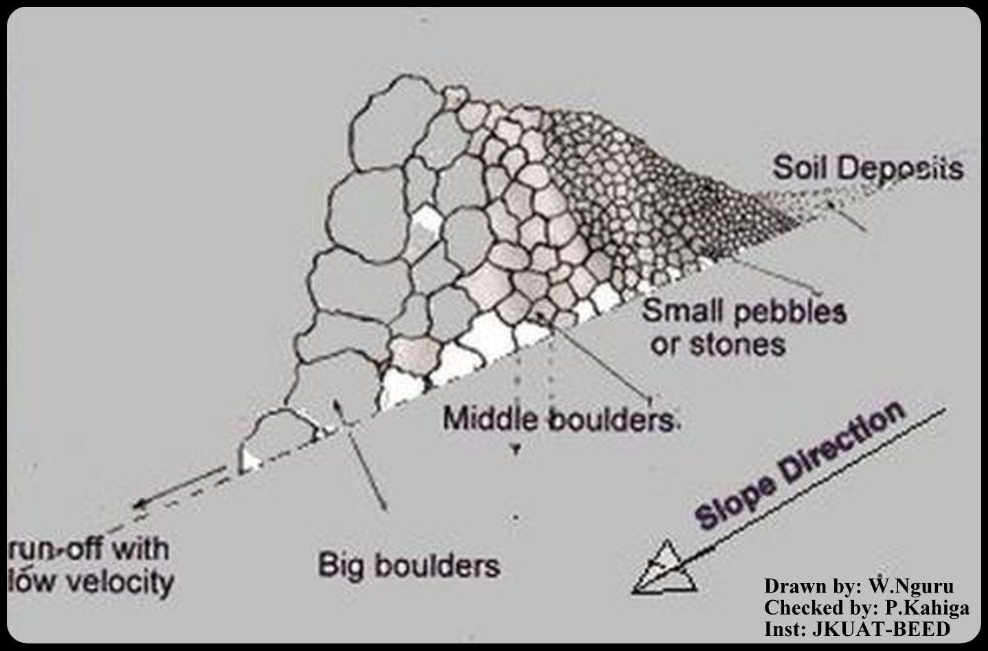
This is a technical drawing representing a cross-section view of how the stonelines are constructed by the emerging farmers in the lower Mbeere South District.
First, a small trench is dug along an established contour line, the farmer starts arranging the stones with reference to their sizes. The bigger ones are arranged on the lower side and the small ones on the upper side as shown on the technical drawing.
By so doing, the eroded soils are trapped on the upper side by the small pebbles, allowing the water to pass through at lower speed hence low erosive capacity.
Location: Ntharawe. Lower Mbeere South District
Date: 2011-08-02
Technical knowledge required for field staff / advisors: moderate (In order to implement this technology, the farmers contact the front line agricultural extension officer in order to assist in making the contours.)
Technical knowledge required for land users: high (Stone required placement of a certain order. Big stone on the lower side and small stones on the upper side-Vertically)
Main technical functions: water spreading, sediment retention / trapping, sediment harvesting
Secondary technical functions: reduction of slope angle
Bund/ bank: graded
Spacing between structures (m): 15
Height of bunds/banks/others (m): 0.8
Width of bunds/banks/others (m): 1.2
Length of bunds/banks/others (m): 27.6
Slope (which determines the spacing indicated above): 8%
Lateral gradient along the structure: 8%
作者:
W.Nguru, P.O.Box 12776-00100 Nairobi
4.2 有关投入和成本计算的一般信息
具体说明成本和投入是如何计算的:
- 每个技术单元
指定单位:
Stonelines
其它/国家货币(具体说明):
Kshs
如相关,注明美元与当地货币的汇率(例如1美元=79.9巴西雷亚尔):1美元=:
80.0
注明雇用劳工的每日平均工资成本:
2.50
4.3 技术建立活动
| 活动 | 时间(季度) | |
|---|---|---|
| 1. | Establish a contour line and dig up a trench upon which the stones will be arranged | yearly |
| 2. | stones are collected and arranged along the established trench. The big boulders are reduced to the required sizes by the use of mattocks | once |
| 3. | The big stones are arranged on the lower side and the rest follows with respect to their sizes on the upper side | |
| 4. | This formation is done per meter length. Mostly is charged 150Kshs per meter. |
4.4 技术建立所需要的费用和投入
| 对投入进行具体说明 | 单位 | 数量 | 单位成本 | 每项投入的总成本 | 土地使用者承担的成本% | |
|---|---|---|---|---|---|---|
| 劳动力 | Establish a contour line | Persons/day | 0.5 | 3.76 | 1.88 | 100.0 |
| 劳动力 | Reduce stone size | Persons/day | 0.5 | 3.76 | 1.88 | 100.0 |
| 劳动力 | Arranging stones | Persons/day | 0.5 | 3.76 | 1.88 | 100.0 |
| 设备 | Mattock | pieces | 1.0 | 18.75 | 18.75 | 100.0 |
| 设备 | Wheelbarrow | pieces | 1.0 | 20.0 | 20.0 | 100.0 |
| 施工材料 | Stone | no | 1.0 | 1.88 | 1.88 | 100.0 |
| 技术建立所需总成本 | 46.27 | |||||
| 技术建立总成本,美元 | 0.58 | |||||
注释:
Duration of establishment phase: 1 month(s)
4.5 维护/经常性活动
| 活动 | 时间/频率 | |
|---|---|---|
| 1. | Repair/Rearrange stone on stone line after a rainy seasons or when people and animals have destroyed the stone line. | yearly during dry season |
4.6 维护/经常性活动所需要的费用和投入(每年)
| 对投入进行具体说明 | 单位 | 数量 | 单位成本 | 每项投入的总成本 | 土地使用者承担的成本% | |
|---|---|---|---|---|---|---|
| 劳动力 | Repair/Rearrange stone | mandays/acre | 14.0 | 2.5 | 35.0 | 100.0 |
| 技术维护所需总成本 | 35.0 | |||||
| 技术维护总成本,美元 | 0.44 | |||||
注释:
Machinery/ tools: A wheel barrow (for carrying) and mattocks (for breaking) may be used
The cost applies for the year 2011 and was calculated per metre square, metre length, metre height and metre width.
4.7 影响成本的最重要因素
描述影响成本的最决定性因素:
The system is labour intensive and hence will affect the cost of constructing the stonelines. However, availability of farm equipments like wheelbarrows, mattocks or oxen will help reduce the total cost and time required for construction and maintaining the stonelines. On steep slopes, the spacing between the lines is small as compared to a relatively gentle slope.
5. 自然和人文环境
5.1 气候
年降雨量
- < 250毫米
- 251-500毫米
- 501-750毫米
- 751-1,000毫米
- 1,001-1,500毫米
- 1,501-2,000毫米
- 2,001-3,000毫米
- 3,001-4,000毫米
- > 4,000毫米
有关降雨的规范/注释:
Annual rainfall: Also < 250 mm
农业气候带
- 半干旱
Thermal climate class: tropics
5.2 地形
平均坡度:
- 水平(0-2%)
- 缓降(3-5%)
- 平缓(6-10%)
- 滚坡(11-15%)
- 崎岖(16-30%)
- 陡峭(31-60%)
- 非常陡峭(>60%)
地形:
- 高原/平原
- 山脊
- 山坡
- 山地斜坡
- 麓坡
- 谷底
垂直分布带:
- 0-100 m a.s.l.
- 101-500 m a.s.l.
- 501-1,000 m a.s.l.
- 1,001-1,500 m a.s.l.
- 1,501-2,000 m a.s.l.
- 2,001-2,500 m a.s.l.
- 2,501-3,000 m a.s.l.
- 3,001-4,000 m a.s.l.
- > 4,000 m a.s.l.
5.3 土壤
平均土层深度:
- 非常浅(0-20厘米)
- 浅(21-50厘米)
- 中等深度(51-80厘米)
- 深(81-120厘米)
- 非常深(> 120厘米)
土壤质地(表土):
- 粗粒/轻(砂质)
表土有机质:
- 低(<1%)
如有可能,附上完整的土壤描述或具体说明可用的信息,例如土壤类型、土壤酸碱度、阳离子交换能力、氮、盐度等。:
Soil texture: With a lot of stones
Soil fertility is medium
Soil drainage / infiltration is medium
Soil water storage capacity is medium
5.4 水资源可用性和质量
地下水位表:
> 50米
地表水的可用性:
匮乏/没有
水质(未处理):
良好饮用水
关于水质和水量的注释和进一步规范:
Availability of surface water: The rivers are seasonal, water availability is from river beds if not during the rainy seasons
5.5 生物多样性
物种多样性:
- 中等
5.6 应用该技术的土地使用者的特征
生产系统的市场定位:
- 混合(生计/商业)
非农收入:
- 低于全部收入的10%
相对财富水平:
- 贫瘠
个人或集体:
- 个人/家庭
机械化水平:
- 手工作业
- 畜力牵引
性别:
- 男人
说明土地使用者的其他有关特征:
Land users applying the Technology are mainly common / average land users
Population density: 10-50 persons/km2
Annual population growth: < 0.5%
80% of the land users are poor.
5.7 应用该技术的土地使用者使用的平均土地面积
- < 0.5 公顷
- 0.5-1 公顷
- 1-2 公顷
- 2-5公顷
- 5-15公顷
- 15-50公顷
- 50-100公顷
- 100-500公顷
- 500-1,000公顷
- 1,000-10,000公顷
- > 10,000公顷
这被认为是小规模、中规模还是大规模的(参照当地实际情况)?:
- 小规模的
5.8 土地所有权、土地使用权和水使用权
土地所有权:
- 个人,有命名
5.9 进入服务和基础设施的通道
健康:
- 贫瘠
- 适度的
- 好
教育:
- 贫瘠
- 适度的
- 好
技术援助:
- 贫瘠
- 适度的
- 好
就业(例如非农):
- 贫瘠
- 适度的
- 好
市场:
- 贫瘠
- 适度的
- 好
能源:
- 贫瘠
- 适度的
- 好
道路和交通:
- 贫瘠
- 适度的
- 好
饮用水和卫生设施:
- 贫瘠
- 适度的
- 好
金融服务:
- 贫瘠
- 适度的
- 好
6. 影响和结论性说明
6.1 该技术的现场影响
社会经济效应
生产
作物生产
生产故障风险
生产区域
土地管理
注释/具体说明:
Such that it hinders mechanisation tractors cannot operate due to the stone line arragement
收入和成本
工作量
注释/具体说明:
The operation is labour intensive
其它社会经济效应
Livelihood and human well-being
注释/具体说明:
Increased food security (the yield near the stoneline is better as compared to the situation that it was before implementation).
社会文化影响
SLM/土地退化知识
社会经济弱势群体的情况
生态影响
土壤
土壤水分
土壤流失
生物多样性:植被、动物
害虫/疾病控制
注释/具体说明:
Snakes and scorpions
减少气候和灾害风险
洪水影响
6.2 该技术的场外影响已经显现
下游洪水
缓冲/过滤能力
6.3 技术对渐变气候以及与气候相关的极端情况/灾害的暴露和敏感性(土地使用者认为的极端情况/灾害)
渐变气候
渐变气候
| 季节 | 增加或减少 | 该技术是如何应对的? | |
|---|---|---|---|
| 年温度 | 增加 | 好 |
气候有关的极端情况(灾害)
气象灾害
| 该技术是如何应对的? | |
|---|---|
| 局地暴雨 | 不好 |
| 局地风暴 | 好 |
气候灾害
| 该技术是如何应对的? | |
|---|---|
| 干旱 | 好 |
水文灾害
| 该技术是如何应对的? | |
|---|---|
| 比较和缓的(河道)洪水 | 不好 |
6.4 成本效益分析
技术收益与技术建立成本相比如何(从土地使用者的角度看)?
短期回报:
稍微积极
长期回报:
积极
技术收益与技术维护成本/经常性成本相比如何(从土地使用者的角度看)?
短期回报:
积极
长期回报:
积极
6.5 技术采用
注释:
There is a moderate trend towards spontaneous adoption of the Technology
Comments on adoption trend: The technology is mainly practiced on the farms with stones even though the farmers admit that the task of construction is labour intensive. However, these not withstanding, the farmers do acknowledge that the technology is beneficial since they can see the results of yields from the ones who are already practicing.
6.7 该技术的优点/长处/机会
| 土地使用者眼中的长处/优势/机会 |
|---|
|
By concentrating the stones along a contour, the farmer is able to make use of the land which otherwise is not possible if the stones are scatered. How can they be sustained / enhanced? Farmers should be encouraged to learn from one another but they should also seek advice from extension officers in making the contours. |
| The cost of replacement of farm equipments (jembes, forks and pangas) is reduced since they aren't broken by stones during land preparation. |
| 编制者或其他关键资源人员认为的长处/优势/机会 |
|---|
|
The stones for constructing the technology are readily available in most of the farms. How can they be sustained / enhanced? Encouraging farmers to use the available stones to put up the technology. |
|
Stoneline technology prevents soil loss due to erosion. How can they be sustained / enhanced? Modification of the technology to allow more infiltration. |
|
No high level technical knowledge is required for construction of stoneline technology. How can they be sustained / enhanced? More farmers should be encouraged to adopt the technology since they dont need a high level of technical knowledge. |
|
Stone lines technology can be modified to prevent soil and water from running off on the side of stone line ridge. How can they be sustained / enhanced? Construction of side ridges. |
6.8 技术的弱点/缺点/风险及其克服方法
| 土地使用者认为的弱点/缺点/风险 | 如何克服它们? |
|---|---|
| Contour profiling is challenging. | Assistance from the front line agricultural extension officers. |
| 编制者或其他关键资源人员认为的弱点/缺点/风险 | 如何克服它们? |
|---|---|
| Labour intensive. | When constructing, always move the stones downslope by gravity instead of moving upwards i.e. start from the contours from the upper side |
| The technology only allows the soil to deposit on the upper side of the stoneline but water passes through. | Proper arrangement of the stones should be enhanced basing on their sizes. |
| Increased habitats for snakes and other dangerous creatures like scorpions that hide on the stonelines. | Where there creatures are prone, the farmers should be careful. |
7. 参考和链接
7.1 信息的方法/来源
7.2 参考可用出版物
标题、作者、年份、ISBN:
Thomas, D.B. (eds) 1997. Soil and Water Conservation Manual for Kenya. Soil and Water Conservation Branch. Ministry of Agriculture, Livestock Development and Marketing. 210 p.
标题、作者、年份、ISBN:
Critchley W and Seigert K (1991) Water Harvesting. FAO
链接和模块
全部展开 全部收起链接
无链接
模块
无模块