Multi-specific plantation of semiarid woody species on terraces with stone walls in ravines and gullies [西班牙]
- 创建:
- 更新:
- 编制者: Susana Bautista
- 编辑者: –
- 审查者: Fabian Ottiger, Alexandra Gavilano
Plantación pluriespecífica de especies leñosas de ambiente semiárido en terrazas con pared de piedra sobre barrancos y c
technologies_1649 - 西班牙
查看章节
全部展开 全部收起1. 一般信息
1.2 参与该技术评估和文件编制的资源人员和机构的联系方式
SLM专业人员:
Urgeghe Anna Maria
Universidad de Alicante
西班牙
SLM专业人员:
Guixot Lorena
Universidad de Alicante
西班牙
Government official:
Bartual Miguel
Conselleria de infrastructuras, territorio y medioambiente
西班牙
有助于对技术进行记录/评估的项目名称(如相关)
Catastrophic shifts in drylands (EU-CASCADE)有助于对技术进行记录/评估的机构名称(如相关)
Conselleria de infrastructuras, territorio y medioambiente - 西班牙有助于对技术进行记录/评估的机构名称(如相关)
Universidad de Alicante (Universidad de Alicante) - 西班牙1.3 关于使用通过WOCAT记录的数据的条件
编制者和关键资源人员接受有关使用通过WOCAT记录数据的条件。:
是
2. SLM技术的说明
2.1 技术简介
技术定义:
Plantation of native semiarid woody species on small terraces with stone walls on ravines and gullies
2.2 技术的详细说明
说明:
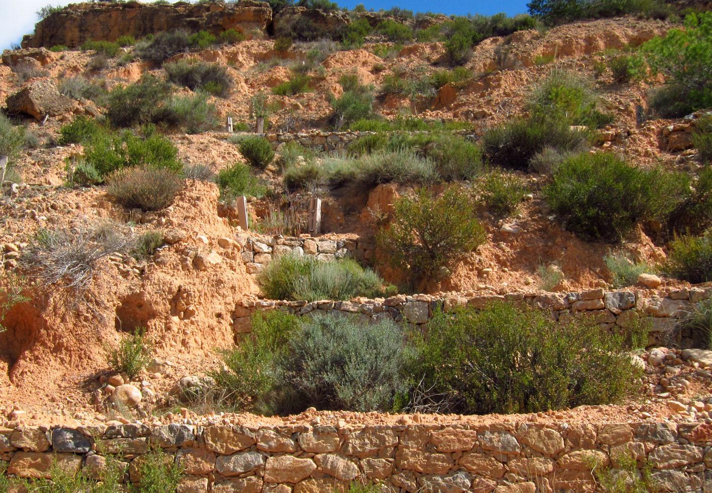
This technology is a restoration technology implemented on ravines and gullies in a degraded semiarid mountain range. The restoration technology consisted of a plantation of seedlings of a variety of native woody species, mostly shrubs, on terraces with stone walls. Using planting holes, one or two rows of seedlings were established on each terrace; Seedlings were protected from extreme radiation and predation by biodegradable seedling shelters. The target area was highly degraded due to long-term overexploitation of resources under harsh environmental conditions. Failed previous reforestation actions on bench terraces led to further degradation in some areas. Degradation resulted in lack of riparian vegetation on the ramblas (ravines with intermittent flow), soil erosion, development of gullies, and frequent floods. To address this problem, the Forest Administration implemented a restoration program on the ravines and gullies of the south-facing side of the Albatera-Crevillente mountain range. The program was implemented in 2006-07.
Purpose of the Technology: The purpose of the restoration was control of concentrated erosion in gullies and ravines; mitigation of landscape degradation; flood prevention; restoration of diversity and cover of vegetation on a degraded semiarid mountain range.
Natural / human environment: The target area is the south-facing side of a mountain range in a semiarid area of Southeast Spain. Exploitation of resources over centuries, mostly grazing and wood gathering, under harsh environmental conditions, led to very low plant cover, mostly consisting of dwarf shrubs sparsed in a matrix of bare soil, lack of riparian vegetation on the ramblas (ravines with intermittent flow), soil erosion, development of gullies, and frequent floods. The exploitation of the land was drastically reduced during the second half of the XXth century due to the general rural land abandonment trend that started in Spain around the 1950’s driven by critical socio-economic changes such as the use of fossil fuels and the sharp increase in activity in the tourism and services business sectors, mostly in the coast land. However, despite the reduction, or even complete abandonment, of rural activity on the mountain range area, there was no sign of spontaneous recovery from degradation. Soil erosion and floods were of major concern for the resource managers in the area (Public Forest Administration), and a number of reforestation and restoration programs have been implemented in the area, with varying degree of success. In more recent decades, new pressures appeared in the mountain area, such as agricultural expansion into the range area (1970s), mining activities (late 1990’s - early 2000’s), and urbanization (2000s). Rural tourism and recreation are new activities in the mountain range area. For the time being, the intensity of these activities is low to moderate. However there is already some evidence of incipient degradation associated to recreation, and some regulation is being demanded by environmental NGOs
2.3 技术照片
媒体库
2.5 已应用该技术的、本评估所涵盖的国家/地区/地点
国家:
西班牙
区域/州/省:
Spain/Alicante
有关地点的进一步说明:
Albatera
具体说明该技术的分布:
- 均匀地分布在一个区域
如果不知道精确的区域,请注明大致覆盖的区域:
- 1-10 平方千米
注释:
Total area covered by the SLM Technology is 5.7 km2.
The MST was applied on the south-facing side of Albatera-Crevillente mountain range. The area consisted of a sequence of southeast and southwest-facing slopes with small ravines (barrrancos) in between. The MST was specifically applied to ravines and gullies.
2.6 实施日期
如果不知道确切的年份,请说明大概的日期:
- 不到10年前(最近)
2.7 技术介绍
详细说明该技术是如何引入的:
- 通过项目/外部干预
3. SLM技术的分类
3.1 该技术的主要目的
- 减少、预防、恢复土地退化
- 保持/提高生物多样性
- 降低灾害风险
3.2 应用该技术的当前土地利用类型
同一土地单元内混合使用的土地::
是

森林/林地
产品和服务:
- 其它森林产品
- 自然保持/保护
- 娱乐/旅游

不毛之地
具体说明:
Trees/ shrubs species: Olea europaea var sylvestris, Ephedra fragilis, Pistacia lentiscus and Pinus halepensis
注释:
Major land use problems (compiler’s opinion): Erosion, water scarcity, low productivity, loss of soil functions (water infiltration, nutrient cycling), low biodiversity, loss of landscape structure, flood risk
Major land use problems (land users’ perception): Low productivity, aridity, limiting conditions for tree cover, erosion
Plantation forestry: Without exploitation
Forest products and services: nature conservation / protection, recreation / tourism
Future (final) land use (after implementation of SLM Technology): Forests / woodlands: Fn: Natural
3.3 由于技术的实施,土地使用是否发生了变化?
注释:
The program was implemented in 2006-07.
3.5 该技术所属的SLM组
- 改良的地面/植被覆盖
- 横坡措施
3.6 包含该技术的可持续土地管理措施

植物措施
- V1:乔木和灌木覆盖层

结构措施
- S1:阶地
3.7 该技术强调的主要土地退化类型

土壤水蚀
- Wg:冲沟侵蚀/沟蚀
- Wo:场外劣化效应

生物性退化
- Bc:植被覆盖的减少
- Bq:数量/生物量减少
- Bs:质量和物种组成/多样性的下降

水质恶化
- Ha:干旱化
- Hs:地表水良变化
注释:
Main type of degradation addressed: Wg: gully erosion / gullying, Wo: offsite degradation effects
Secondary types of degradation addressed: Bc: reduction of vegetation cover, Bq: quantity / biomass decline, Bs: quality and species composition /diversity decline, Ha: aridification, Hs: change in quantity of surface water
Main causes of degradation: deforestation / removal of natural vegetation (incl. forest fires) (Agricultural land expansion. Starting in 1965, peaking in late 1970’s), over-exploitation of vegetation for domestic use (Peaking during 1940’s), poverty / wealth (Poverty)
Secondary causes of degradation: overgrazing (Peaking during 1940’s), industrial activities and mining (Late 1990’s - early 2000’s), urbanisation and infrastructure development (Last 10 years), droughts, population pressure (Relative demographic pressure given the low productivity of the land), land tenure (Lack of proper land demarcation until late 1990’s - early 2000’s, leading to misuse and mismanagement of public land)
3.8 防止、减少或恢复土地退化
注释:
Main goals: rehabilitation / reclamation of denuded land
Secondary goals: prevention of land degradation, mitigation / reduction of land degradation
4. 技术规范、实施活动、投入和成本
4.1 该技术的技术图纸
技术规范(与技术图纸相关):
Technical knowledge required for field staff / advisors: moderate (Needed for field implementation: soil preparation, planting techniques)
Technical knowledge required for land users: high (Land users are Forest Administration staff. High technical knowledge is require for the design of technology implementation)
Main technical functions: control of dispersed runoff: retain / trap, control of dispersed runoff: impede / retard, control of concentrated runoff: retain / trap, control of concentrated runoff: impede / retard, reduction of slope angle
Secondary technical functions: control of raindrop splash, reduction of slope length, improvement of ground cover, increase of surface roughness, improvement of surface structure (crusting, sealing), improvement of topsoil structure (compaction), stabilisation of soil (eg by tree roots against land slides), increase in organic matter, increase in nutrient availability (supply, recycling,…), increase of infiltration, increase / maintain water stored in soil, sediment retention / trapping, sediment harvesting, increase of biomass (quantity), promotion of vegetation species and varieties (quality, eg palatable fodder)
Vegetative measure: Staggered pattern
Vegetative material: T : trees / shrubs
Number of plants per (ha): 610
Spacing between rows / strips / blocks (m): 5
Vertical interval within rows / strips / blocks (m): 5
Vegetative measure: Vegetative material: T : trees / shrubs
Vegetative measure: Vegetative material: T : trees / shrubs
Vegetative measure: Vegetative material: T : trees / shrubs
Trees/ shrubs species: Olea europaea var sylvestris, Ephedra fragilis, Pistacia lentiscus and Pinus halepensis
Wall/ barrier
Height of bunds/banks/others (m): 1-2
Width of bunds/banks/others (m): 1
Length of bunds/banks/others (m): variable
Terrace: bench level
Vertical interval between structures (m): 1-2
Spacing between structures (m): 4-6
Length of bunds/banks/others (m): 3-6
Construction material (other): sandbag
Slope (which determines the spacing indicated above): 25%
Lateral gradient along the structure: 0%
Vegetation is used for stabilisation of structures.
4.2 有关投入和成本计算的一般信息
其它/国家货币(具体说明):
Euro
如相关,注明美元与当地货币的汇率(例如1美元=79.9巴西雷亚尔):1美元=:
0.79
4.3 技术建立活动
| 活动 | 时间(季度) | |
|---|---|---|
| 1. | Building small walls and terraces in ravines and gullies | |
| 2. | Soil preparation and planting holes | during winter |
| 3. | Soil and microcatchment preparation | during winter |
| 4. | Fertilization plantation (holes) | Winter |
| 5. | Fertilization microcatchment | Winter |
| 6. | Plantation (in holes) | during winter |
| 7. | Plantation (microcatchments) | during winter |
| 8. | Tree shelter placement | late winter |
| 9. | tree shelter placement (Microcatchments) | late winter |
4.4 技术建立所需要的费用和投入
| 对投入进行具体说明 | 单位 | 数量 | 单位成本 | 每项投入的总成本 | 土地使用者承担的成本% | |
|---|---|---|---|---|---|---|
| 劳动力 | Labour | ha | 1.0 | 1796.0 | 1796.0 | 100.0 |
| 设备 | Machine use | ha | 1.0 | 853.0 | 853.0 | 100.0 |
| 植物材料 | Seedlings | ha | 1.0 | 252.0 | 252.0 | 100.0 |
| 肥料和杀菌剂 | Compost/manure | ha | 1.0 | 154.0 | 154.0 | 100.0 |
| 其它 | Three shelters | ha | 1.0 | 424.0 | 424.0 | 100.0 |
| 技术建立所需总成本 | 3479.0 | |||||
| 技术建立总成本,美元 | 4403.8 | |||||
注释:
Duration of establishment phase: 5 month(s)
4.6 维护/经常性活动所需要的费用和投入(每年)
注释:
Machinery/ tools: Walking Excavator
5. 自然和人文环境
5.1 气候
年降雨量
- < 250毫米
- 251-500毫米
- 501-750毫米
- 751-1,000毫米
- 1,001-1,500毫米
- 1,501-2,000毫米
- 2,001-3,000毫米
- 3,001-4,000毫米
- > 4,000毫米
有关降雨的规范/注释:
280 mm (mean 1958 – 2007) Rainy seasons: spring and autumn
农业气候带
- 半干旱
Thermal climate class: subtropics
5.2 地形
平均坡度:
- 水平(0-2%)
- 缓降(3-5%)
- 平缓(6-10%)
- 滚坡(11-15%)
- 崎岖(16-30%)
- 陡峭(31-60%)
- 非常陡峭(>60%)
地形:
- 高原/平原
- 山脊
- 山坡
- 山地斜坡
- 麓坡
- 谷底
垂直分布带:
- 0-100 m a.s.l.
- 101-500 m a.s.l.
- 501-1,000 m a.s.l.
- 1,001-1,500 m a.s.l.
- 1,501-2,000 m a.s.l.
- 2,001-2,500 m a.s.l.
- 2,501-3,000 m a.s.l.
- 3,001-4,000 m a.s.l.
- > 4,000 m a.s.l.
说明该技术是否专门应用于:
- 不相关
5.3 土壤
平均土层深度:
- 非常浅(0-20厘米)
- 浅(21-50厘米)
- 中等深度(51-80厘米)
- 深(81-120厘米)
- 非常深(> 120厘米)
土壤质地(表土):
- 粗粒/轻(砂质)
- 中粒(壤土、粉土)
表土有机质:
- 中(1-3%)
如有可能,附上完整的土壤描述或具体说明可用的信息,例如土壤类型、土壤酸碱度、阳离子交换能力、氮、盐度等。:
Soil texture is medium (Sandy- loam (dominant))
Soil fertility is low
Soil drainage/infiltration is good
Soil water storage capacity is medium
5.4 水资源可用性和质量
地下水位表:
> 50米
地表水的可用性:
匮乏/没有
水质(未处理):
仅供农业使用(灌溉)
关于水质和水量的注释和进一步规范:
Water quality (untreated): For agricultural use only (irrigation)(groundwater)
5.5 生物多样性
物种多样性:
- 中等
5.6 应用该技术的土地使用者的特征
非农收入:
- > 收入的50%
个人或集体:
- 员工(公司、政府)
性别:
- 女人
- 男人
说明土地使用者的其他有关特征:
Land users applying the Technology are mainly Leaders / privileged
Population density: 100-200 persons/km2
Annual population growth: 2% - 3%
Market orientation of production system: No forestry production
5.7 应用该技术的土地使用者使用的平均土地面积
- < 0.5 公顷
- 0.5-1 公顷
- 1-2 公顷
- 2-5公顷
- 5-15公顷
- 15-50公顷
- 50-100公顷
- 100-500公顷
- 500-1,000公顷
- 1,000-10,000公顷
- > 10,000公顷
这被认为是小规模、中规模还是大规模的(参照当地实际情况)?:
- 大规模的
注释:
Public land
5.8 土地所有权、土地使用权和水使用权
土地所有权:
- 州
土地使用权:
- 自由进入(无组织)
5.9 进入服务和基础设施的通道
健康:
- 贫瘠
- 适度的
- 好
教育:
- 贫瘠
- 适度的
- 好
技术援助:
- 贫瘠
- 适度的
- 好
就业(例如非农):
- 贫瘠
- 适度的
- 好
市场:
- 贫瘠
- 适度的
- 好
能源:
- 贫瘠
- 适度的
- 好
道路和交通:
- 贫瘠
- 适度的
- 好
饮用水和卫生设施:
- 贫瘠
- 适度的
- 好
金融服务:
- 贫瘠
- 适度的
- 好
6. 影响和结论性说明
6.1 该技术的现场影响
社会文化影响
娱乐机会
SLM/土地退化知识
Improved livelihoods and human well-being
注释/具体说明:
Recreational use
生态影响
水循环/径流
水的回收/收集
地表径流
蒸发
土壤
土壤水分
土壤覆盖层
土壤流失
养分循环/补给
土壤有机物/地下C
生物多样性:植被、动物
生物量/地上C
植物多样性
动物多样性
有益物种
栖息地多样性
6.2 该技术的场外影响已经显现
下游洪水
6.3 技术对渐变气候以及与气候相关的极端情况/灾害的暴露和敏感性(土地使用者认为的极端情况/灾害)
渐变气候
渐变气候
| 季节 | 增加或减少 | 该技术是如何应对的? | |
|---|---|---|---|
| 年温度 | 增加 | 好 |
气候有关的极端情况(灾害)
气象灾害
| 该技术是如何应对的? | |
|---|---|
| 局地暴雨 | 不好 |
| 局地风暴 | 未知 |
气候灾害
| 该技术是如何应对的? | |
|---|---|
| 干旱 | 不好 |
水文灾害
| 该技术是如何应对的? | |
|---|---|
| 比较和缓的(河道)洪水 | 未知 |
其他气候相关的后果
其他气候相关的后果
| 该技术是如何应对的? | |
|---|---|
| 缩短生长期 | 好 |
6.4 成本效益分析
技术收益与技术建立成本相比如何(从土地使用者的角度看)?
短期回报:
轻度消极
长期回报:
积极
7. 参考和链接
7.1 信息的方法/来源
链接和模块
全部展开 全部收起链接
无链接
模块
无模块