Grass buffer zones alongside waterways in cropland [挪威]
- 创建:
- 更新:
- 编制者: Kamilla Skaalsveen
- 编辑者: Anne-Grete Buseth Blankenberg, Dominika Krzeminska, Zhanguo Bai
- 审查者: Rima Mekdaschi Studer, William Critchley
Grasdekt buffersone
technologies_1656 - 挪威
- Grass buffer zones alongside waterways in cropland: Feb. 3, 2023 (public)
- Grass buffer zones alongside waterways in cropland: June 17, 2022 (inactive)
- Grass Covered Riparian Buffer Strips: Sept. 5, 2019 (inactive)
- Grass Covered Riparian Buffer Strips: March 16, 2017 (inactive)
- Grass Covered Riparian Buffer Strips: March 16, 2017 (inactive)
查看章节
全部展开 全部收起1. 一般信息
1.2 参与该技术评估和文件编制的资源人员和机构的联系方式
SLM专业人员:
SLM专业人员:
有助于对技术进行记录/评估的项目名称(如相关)
OPtimal strategies to retAIN and re-use water and nutrients in small agricultural catchments across different soil-climatic regions in Europe (OPTAIN)有助于对技术进行记录/评估的项目名称(如相关)
Preventing and Remediating degradation of soils in Europe through Land Care (EU-RECARE )有助于对技术进行记录/评估的机构名称(如相关)
Norwegian Institute for Agricultural and Environme (Norwegian Institute for Agricultural and Environme) - 挪威1.3 关于使用通过WOCAT记录的数据的条件
编制者和关键资源人员接受有关使用通过WOCAT记录数据的条件。:
是
1.4 所述技术的可持续性声明
这里所描述的技术在土地退化方面是否存在问题,导致无法被认为是一种可持续的土地管理技术?:
否
1.5 参考关于SLM方法(使用WOCAT记录的SLM方法)的调查问卷

Regional Environmental program [挪威]
Regulations and financial grants for reduction of pollution and promotion of the cultural landscape.
- 编制者: Kamilla Skaalsveen
2. SLM技术的说明
2.1 技术简介
技术定义:
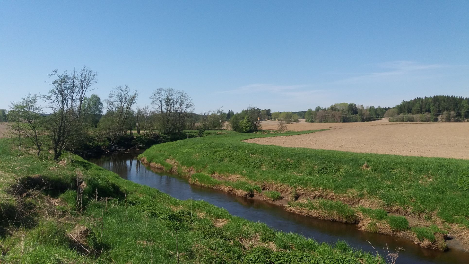
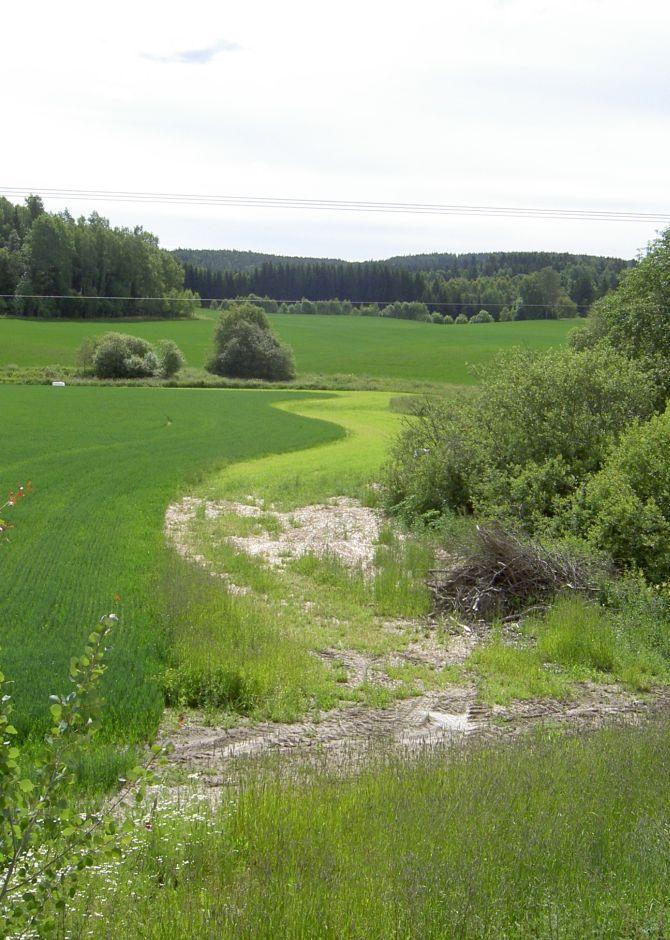
Grass buffer zones are established along waterways in cropland to reduce the surface runoff rate, and the amounts of sediment, nutrients and pesticides in the runoff.
2.2 技术的详细说明
说明:
Commonly used names: buffer zones, buffer strips, riparian buffers
Purpose/aim: Vegetative buffers are areas of permanent vegetation located within and between agricultural fields and the watercourses to which they drain. The purpose of the vegetative buffer is to intercept, and reduce the rates of surface runoff and to reduce loads of sediment, nutrients and pesticide delivered to waterways. The processes involved are filtration, sedimentation, infiltration and absorption. Reducing the input of particles and nutrients into surface waterways is desirable both to improve water quality and to prevent eutrophication of downstream water bodies. In Norway, buffer zones are primarily established to reduce surface runoff of particles and phosphorus. However, vegetation in these zones can also serve other useful functions, such as protection against bank erosion, production of biomass, and/or provision of habitats for wildlife.
Establishment/maintenance activities:
Buffer zones are most commonly designed to retain inputs of nutrients and particles from adjacent fields. Vegetative buffers may be constructed or naturally vegetated, within or alongside fields, or adjacent to drainage ditches, streams, lakes, ponds, and wetlands. The buffer zones may consist of grass for fodder production, or be natural vegetation composed of herbs, weeds, bushes and trees.
In Norway, farmers receive subsidies when the area is still used for production, e.g. grass production for fodder. Farmers leave a strip in cropland for grass and herbs to grow alongside rivers, streams and lakes that intersect their cropland areas. It is recommended to sow grass when establishing grass buffer zones. Robust and dense grass types with a high uptake of nutrients are often the best suited for the purpose. The grass strips should generally not be ploughed, fertilized or treated by herbicides, but some exceptions may be made. The degree to which the grass is harvested varies with the grass type and if it is valuable for livestock fodder.
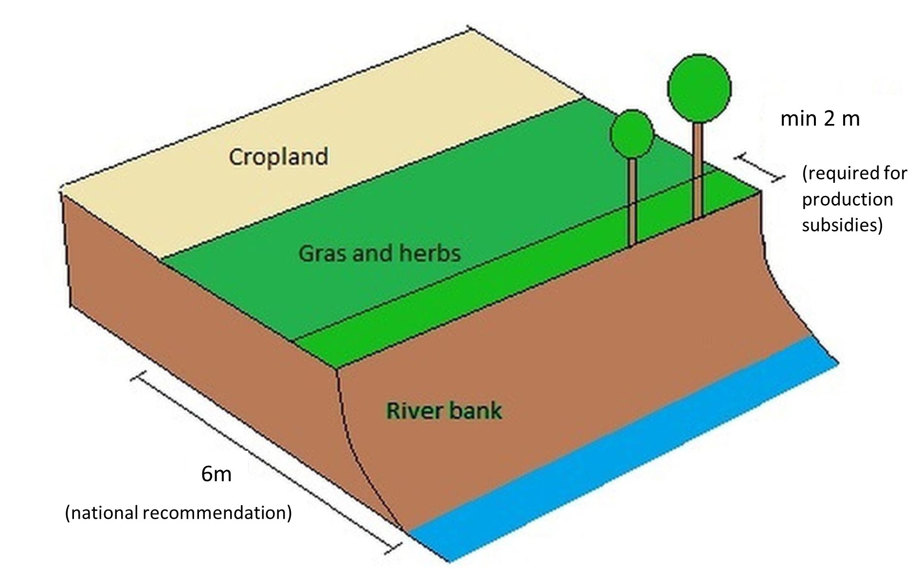
Buffer zones are one of the most common measures in Norway, and the requirements for the dimension of buffer zones have changed with time - and depend on the region. According to current regulations, buffer zones between the field and the watercourse have to be a minimum of 2 meters in order to qualify for production subsidies (PT-forskriften, § 4). In addition, there is a national recommendation (RMP) to maintain a minimum 6-metre wide buffer zone along all watercourses. However, regional guidelines (RMP) can differ from national ones and the width recommendation differ from county to county.
Benefits/impact: The effectiveness of buffer zones in retaining nutrients and soil particles has been explored by many authors. Retention capacity for phosphorus in buffer zones depends on several factors including vegetation, soil type, slope, hydrological conditions, and the width of the zone. There are large variations in the effectiveness of buffer zones: 32-91% retention of sediment, 26-100% retention of phosphorus and 0-100% retention of nitrogen. The retention effect of grass buffer zones along the Hobøl River, measured with rainfall simulation experiments under the BUFFERKLIMA project (Krzeminska et al., 2020), was: 86-94% for sediment, 86-86% for phosphorus and 78-89% for nitrogen.
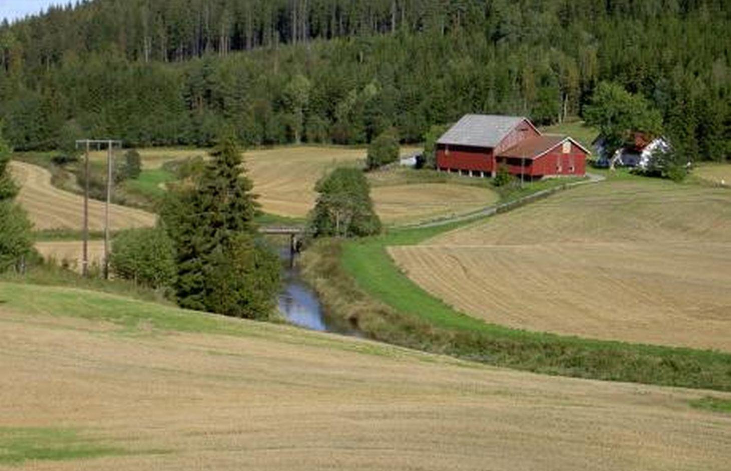
Natural / human environment: The information about this Technology is based on investigations and/or reports from different part of Norway. For the purpose of the OPTAIN project, the technology is further presented in the natural and human environment context of the Kråkstad River catchment - a Norwegian Case Study catchment within the project.
The Kråkstad River is mainly situated in the Ski municipality in the South-Eastern part of Norway. The river catchment is a western tributary of the Vansjø-Hobøl watercourse, also known as the Morsa watercourse. The Kråkstad River catchment area is c. 51 km², 43% of which is agricultural land. Cereals are the major crop, produced on the heavy clays soils. The main environmental challenge in the area is water quality (incl. high phosphorus pollution) and soil erosion (incl. riverbank erosion and quick-clay landslides).The Morsa watercourse is a drinking water resource and there are specific environmental regulations for land management supported by subsidies through the Regional Environmental Programme (RMP).
2.3 技术照片
媒体库
2.5 已应用该技术的、本评估所涵盖的国家/地区/地点
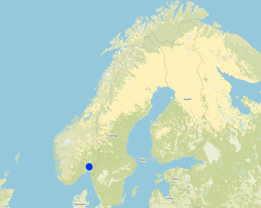
国家:
挪威
区域/州/省:
Viken county
有关地点的进一步说明:
The Vansjø - Hobøl catchment
具体说明该技术的分布:
- 均匀地分布在一个区域
如果不知道精确的区域,请注明大致覆盖的区域:
- 1-10 平方千米
技术现场是否位于永久保护区?:
否
Map
×2.6 实施日期
如果不知道确切的年份,请说明大概的日期:
- 10-50年前
2.7 技术介绍
详细说明该技术是如何引入的:
- 在实验/研究期间
- 通过项目/外部干预
- Regional Environmental Programme (RMP)
注释(项目类型等):
The Morsa Project (morsa.org)
Buffer zones along streams and lakes are measures eligible for subsidies under the Regional Environmental Programme (RMP).
3. SLM技术的分类
3.1 该技术的主要目的
- 减少、预防、恢复土地退化
- 结合其他技术保护流域/下游区域
3.2 应用该技术的当前土地利用类型

农田
- 一年一作
年作 - 具体指明作物:
- 谷类 - 其他
- small grains
每年的生长季节数:
- 1
具体说明:
Longest growing period in days: 135Longest growing period from month to month: May to mid September

森林/林地
产品和服务:
- 薪材
注释:
Major land use problems (compiler’s opinion): Erosion, flooding and landslides, eutrophication of rivers and lakes.
Major land use problems (land users’ perception): Cropland is occupied by the buffer strips, which may lead to decreased production and loss of income.
3.3 由于技术的实施,土地使用是否发生了变化?
由于技术的实施,土地使用是否发生了变化?:
- 是(请在技术实施前填写以下有关土地利用的问题)
同一土地单元内混合使用的土地::
否
农田
- 一年一作
年作 - 具体指明作物:
- 饲料作物 - 草
注释:
When buffer zones are implemented, part of the cropland is occupied by the grass strips. The grass strips should generally not be ploughed, fertilized or treated by herbicides, but some exceptions may be made. The degree to which it is harvested varies with the grass type, and if it is used for animal fodder.
3.4 供水
该技术所应用土地的供水:
- 雨养
3.5 该技术所属的SLM组
- 地表水管理(泉、河、湖、海)
3.6 包含该技术的可持续土地管理措施

植物措施
- V2:草和多年生草本植物
3.7 该技术强调的主要土地退化类型

土壤水蚀
- Wt:表土流失/地表侵蚀
- Wg:冲沟侵蚀/沟蚀
- Wm:块体运动/滑坡
- Wr:河岸侵蚀

水质恶化
- Hp:地表水水质下降
注释:
Main type of degradation addressed:
Wt: loss of topsoil / surface erosion
Hp: decline of surface water quality
Secondary types of degradation addressed:
Wg: gully erosion/gullying,
Wr: riverbank erosion
Wm: mass movements/landslides,
Main causes of degradation:
soil management - use of fertilizer and heavy machinery (compression of the soil and low infiltration rate)
crop management - annual, perennial, tree/shrub
heavy / extreme rainfall (intensity/amounts) - more flooding and erosion, floods
Secondary causes of degradation:
deforestation / removal of natural vegetation (incl. forest fires) - the runoff has a lower retention time in the forest. Leads to higher velocity and more flooding of downstream cropland areas),
change of seasonal rainfall - heavier rainfall events due to climate change,
land tenure
governance / institutional
3.8 防止、减少或恢复土地退化
具体数量名该技术与土地退化有关的目标:
- 防止土地退化
- 减少土地退化
注释:
Main goals: mitigation / reduction of land degradation
Secondary goals: prevention of land degradation
4. 技术规范、实施活动、投入和成本
4.1 该技术的技术图纸
技术规范(与技术图纸相关):
A technical drawing of a grass buffer zone - example setup based on the Norwegian recomendation
Technical knowledge required for field staff / advisors: low
Technical knowledge required for land users: low
Main technical functions: control of concentrated runoff: impede / retard
Secondary technical functions: control of raindrop splash, control of dispersed runoff: retain / trap, control of dispersed runoff: impede / retard, control of concentrated runoff: retain / trap, improvement of ground cover, increase of surface roughness, increase of infiltration, increase / maintain water stored in soil, improvement of water quality, buffering / filtering water, sediment retention / trapping, sediment harvesting
Aligned: -along boundary
Vegetative material: T : trees / shrubs
Vegetative measure: Along waterways
Vegetative material: G : grass
Trees/ shrubs species: Naturally
Grass species: Seeded
作者:
Kamilla Skaalsveen
4.2 有关投入和成本计算的一般信息
具体说明成本和投入是如何计算的:
- 每个技术单元
指定单位:
a buffer zone strip along the stream or lake
指定单位面积(如相关):
dimensions can vary greatly
其它/国家货币(具体说明):
Kroner (NOK)
如相关,注明美元与当地货币的汇率(例如1美元=79.9巴西雷亚尔):1美元=:
8.89
注明雇用劳工的每日平均工资成本:
c.a. 3000 NOK (it is only the cost of the time assuming 8h work per day, 320-500 NOK/hour; person; machinery, equipment, materials not included)
4.3 技术建立活动
| 活动 | 时间(季度) | |
|---|---|---|
| 1. | Plowing | 1 time/yr |
| 2. | Harrowing | 2-3 times/yr |
| 3. | Sowing grass | 2-3 times/yr |
| 4. | Harvesting grass | 2-3 times/yr |
4.4 技术建立所需要的费用和投入
| 对投入进行具体说明 | 单位 | 数量 | 单位成本 | 每项投入的总成本 | 土地使用者承担的成本% | |
|---|---|---|---|---|---|---|
| 劳动力 | Ploughing | zone/farmer/day | 1.0 | 321.0 | 321.0 | 7.0 |
| 劳动力 | Harrowing | zone/farmer/day | 1.0 | 321.0 | 321.0 | 7.0 |
| 劳动力 | Sowing grass | zone/farmer/day | 1.0 | 321.0 | 321.0 | 7.0 |
| 劳动力 | Harvesting grass | zone/farmer/day | 1.0 | 321.0 | 321.0 | 7.0 |
| 技术建立所需总成本 | 1284.0 | |||||
| 技术建立总成本,美元 | 144.43 | |||||
如果土地使用者负担的费用少于100%,请注明由谁负担其余费用:
Grass covered buffer zones are measures eligible for subsidies under the Regional Environmental Programme (RMP)
注释:
The costs of establishment and management of grass covered buffer zone are the same as in the case of regular crop land management. The subsidy is compensation for land withdrawn from the main production (crop land).
Grass covered buffer zones are measures eligible for subsidies under Regional Environmental Programme (RMP) - between 2019 and 2022 the subsidy for grass covered buffer zones was 15 kr/m in Viken county.
4.5 维护/经常性活动
| 活动 | 时间/频率 | |
|---|---|---|
| 1. | Ploughing | Every 5th year |
| 2. | Harrowing | Every 5th year |
| 3. | Sowing grass | Every 5th year |
| 4. | Harvesting grass | 1-2 times/yr |
注释:
These areas are often used as grass production areas so some maintenance and harvesting of grass is needed.
4.6 维护/经常性活动所需要的费用和投入(每年)
| 对投入进行具体说明 | 单位 | 数量 | 单位成本 | 每项投入的总成本 | 土地使用者承担的成本% | |
|---|---|---|---|---|---|---|
| 劳动力 | Ploughing | zone/farmer/day | 1.0 | 53.0 | 53.0 | |
| 劳动力 | Harrowing | zone/farmer/day | 1.0 | 321.0 | 321.0 | |
| 劳动力 | Sowing grass | Day | 1.0 | 321.0 | 321.0 | |
| 劳动力 | Harvesting grass | Day | 1.0 | 321.0 | 321.0 | |
| 技术维护所需总成本 | 1016.0 | |||||
| 技术维护总成本,美元 | 114.29 | |||||
如果土地使用者负担的费用少于100%,请注明由谁负担其余费用:
Grass covered buffer zones are eligible for subsidies under the Regional Environmental Programme (RMP)
注释:
The costs of establishment and management of grass covered buffer zones are are the same as in case of regular crop land management.
Maintenance of grassed buffer zones is a part of the subsidy system:
-production subsidies - the regulations relating to production subsidies include a number of environmental standards that farmers must meet to receive production support, including two-metre buffer zones along water ways. A farmer who does not comply with the requirements may lose part of their production subsidies.
- RMP - Buffer zones may be eligible for subsidies under the Regional Environmental Programme (RMP) – for 2019-2022 the subsidy level for maintaining grass covered buffer zones was 15 kr/m in the Viken region. The subsidy is compensation for land withdrawn from the main production (crop land).
4.7 影响成本的最重要因素
描述影响成本的最决定性因素:
The costs of establishment and management of grass buffer zone are are the same as in case of regular crop land management. The subsidy is compensation for land withdrawn from the main production (crop land).
Establishment and maintenance costs of buffer strip depends mostly on:
- the area (width and continuity) of the buffer strip.
- type of vegetation
- possibility to use the grass as a fodder.
5. 自然和人文环境
5.1 气候
年降雨量
- < 250毫米
- 251-500毫米
- 501-750毫米
- 751-1,000毫米
- 1,001-1,500毫米
- 1,501-2,000毫米
- 2,001-3,000毫米
- 3,001-4,000毫米
- > 4,000毫米
农业气候带
- 半湿润
- 半干旱
Thermal climate class: temperate
Thermal climate class: boreal
5.2 地形
平均坡度:
- 水平(0-2%)
- 缓降(3-5%)
- 平缓(6-10%)
- 滚坡(11-15%)
- 崎岖(16-30%)
- 陡峭(31-60%)
- 非常陡峭(>60%)
地形:
- 高原/平原
- 山脊
- 山坡
- 山地斜坡
- 麓坡
- 谷底
垂直分布带:
- 0-100 m a.s.l.
- 101-500 m a.s.l.
- 501-1,000 m a.s.l.
- 1,001-1,500 m a.s.l.
- 1,501-2,000 m a.s.l.
- 2,001-2,500 m a.s.l.
- 2,501-3,000 m a.s.l.
- 3,001-4,000 m a.s.l.
- > 4,000 m a.s.l.
5.3 土壤
平均土层深度:
- 非常浅(0-20厘米)
- 浅(21-50厘米)
- 中等深度(51-80厘米)
- 深(81-120厘米)
- 非常深(> 120厘米)
土壤质地(表土):
- 中粒(壤土、粉土)
- 细粒/重质(粘土)
土壤质地(地表以下> 20厘米):
- 中粒(壤土、粉土)
- 细粒/重质(粘土)
表土有机质:
- 中(1-3%)
如有可能,附上完整的土壤描述或具体说明可用的信息,例如土壤类型、土壤酸碱度、阳离子交换能力、氮、盐度等。:
Soil fertility is medium-high
Soil drainage/infiltration is poor
Soil water storage capacity is very low-low
5.4 水资源可用性和质量
地下水位表:
< 5米
地表水的可用性:
好
水质(未处理):
仅供农业使用(灌溉)
水质请参考::
地下水和地表水
水的盐度有问题吗?:
否
该区域正在发生洪水吗?:
是
规律性:
频繁
5.5 生物多样性
物种多样性:
- 低
栖息地多样性:
- 低
5.6 应用该技术的土地使用者的特征
定栖或游牧:
- 定栖的
生产系统的市场定位:
- 混合(生计/商业)
- 商业/市场
非农收入:
- 收入的10-50%
- > 收入的50%
相对财富水平:
- 平均水平
- 丰富
个人或集体:
- 个人/家庭
机械化水平:
- 机械化/电动
性别:
- 女人
- 男人
土地使用者的年龄:
- 青年人
- 中年人
说明土地使用者的其他有关特征:
Land users applying the Technology are mainly common / average land users
Population density: < 10 persons/km2
Annual population growth: < 0.5%
10% of the land users are rich and own 10% of the land.
90% of the land users are average wealthy and own 90% of the land.
5.7 应用该技术的土地使用者使用的平均土地面积
- < 0.5 公顷
- 0.5-1 公顷
- 1-2 公顷
- 2-5公顷
- 5-15公顷
- 15-50公顷
- 50-100公顷
- 100-500公顷
- 500-1,000公顷
- 1,000-10,000公顷
- > 10,000公顷
这被认为是小规模、中规模还是大规模的(参照当地实际情况)?:
- 中等规模的
5.8 土地所有权、土地使用权和水使用权
土地所有权:
- 个人,有命名
土地使用权:
- 社区(有组织)
- 个人
用水权:
- 自由进入(无组织)
5.9 进入服务和基础设施的通道
健康:
- 贫瘠
- 适度的
- 好
教育:
- 贫瘠
- 适度的
- 好
技术援助:
- 贫瘠
- 适度的
- 好
就业(例如非农):
- 贫瘠
- 适度的
- 好
市场:
- 贫瘠
- 适度的
- 好
能源:
- 贫瘠
- 适度的
- 好
道路和交通:
- 贫瘠
- 适度的
- 好
饮用水和卫生设施:
- 贫瘠
- 适度的
- 好
金融服务:
- 贫瘠
- 适度的
- 好
6. 影响和结论性说明
6.1 该技术的现场影响
社会经济效应
生产
作物生产
生产区域
注释/具体说明:
The grass (from buffer strips) is often unfit for fodder
收入和成本
农业收入
注释/具体说明:
Despite subsidies, many farmers view grass buffer zones as a financial loss since the grass is often unfit for fodder.
收入来源的多样性
工作量
社会文化影响
Improved livelihoods and human well-being
注释/具体说明:
Because of the drinking water quality
生态影响
水循环/径流
水质
注释/具体说明:
less sediment and nutrient input to surface water
土壤
土壤覆盖层
土壤流失
土壤压实
养分循环/补给
生物多样性:植被、动物
植物多样性
有益物种
栖息地多样性
6.2 该技术的场外影响已经显现
地下水/河流污染
缓冲/过滤能力
6.3 技术对渐变气候以及与气候相关的极端情况/灾害的暴露和敏感性(土地使用者认为的极端情况/灾害)
渐变气候
渐变气候
| 季节 | 增加或减少 | 该技术是如何应对的? | |
|---|---|---|---|
| 年温度 | 增加 | 好 | |
| 年降雨量 | 增加 | 好 |
气候有关的极端情况(灾害)
气象灾害
| 该技术是如何应对的? | |
|---|---|
| 局地暴雨 | 适度 |
| 局地风暴 | 好 |
气候灾害
| 该技术是如何应对的? | |
|---|---|
| 干旱 | 好 |
水文灾害
| 该技术是如何应对的? | |
|---|---|
| 比较和缓的(河道)洪水 | 适度 |
其他气候相关的后果
其他气候相关的后果
| 该技术是如何应对的? | |
|---|---|
| 缩短生长期 | 好 |
6.4 成本效益分析
技术收益与技术建立成本相比如何(从土地使用者的角度看)?
短期回报:
轻度消极
长期回报:
中性/平衡
技术收益与技术维护成本/经常性成本相比如何(从土地使用者的角度看)?
短期回报:
轻度消极
长期回报:
轻度消极
6.5 技术采用
- 11-50%
在所有采用这项技术的人当中,有多少人是自发的,即未获得任何物质奖励/付款?:
- 0-10%
注释:
There is no trend towards spontaneous adoption of the Technology. Doubts about the retention capacity of buffer zones reduce farmers’ motivation.
Local regulations determine that farmers only receive subsidies per production area along with financial grants if they implement the technology.
6.6 适应
最近是否对该技术进行了修改以适应不断变化的条件?:
否
6.7 该技术的优点/长处/机会
| 土地使用者眼中的长处/优势/机会 |
|---|
| Probably good for the environment |
| 编制者或其他关键资源人员认为的长处/优势/机会 |
|---|
|
The grass captures sediments and nutrients from the cropland How can they be sustained / enhanced? May be more efficient with a change in grass type (but this has not been not tested) |
|
Reduced fertilizer usage How can they be sustained / enhanced? Continue in the same way |
|
Co-operation between farmers How can they be sustained / enhanced? Joint utilization of the buffer strips for grass production |
6.8 技术的弱点/缺点/风险及其克服方法
| 土地使用者认为的弱点/缺点/风险 | 如何克服它们? |
|---|---|
| Loss of productive cropland | Narrower buffer strips |
| Not always good for the farm economy | Review the subsidies scheme |
| Doubts about the effectiveness of the technology (infiltration and stream bank erosion) |
| 编制者或其他关键资源人员认为的弱点/缺点/风险 | 如何克服它们? |
|---|---|
| Low infiltration rates | Less heavy machinery on the buffer strips and a wider zone of natural vegetation along the banks |
7. 参考和链接
7.1 信息的方法/来源
- 实地考察、实地调查
BUFFERKLIMA project (Krzeminska et al 2020)
Projects within Halden, MORSA and PURA water region (Blankenberg and Skarbøvik, 2020)
- 根据报告和其他现有文档进行编译
(现场)数据是什么时候汇编的?:
10/02/2022
7.2 参考可用出版物
标题、作者、年份、ISBN:
Blankenberg, A-G.B., Skarbøvik E., 2020. Phosphorus retention, erosion protection and farmers’ perceptions of riparian buffer zones with grass and natural vegetation: Case studies from South-Eastern Norway.
可以从哪里获得?成本如何?
Ambio
标题、作者、年份、ISBN:
Krzeminska D, Blankenberg A‐G, Bøe F, Nemes A, Skarbøvik E. 2020.Renseeffekt og kanterosjon i kantsoner med forskjellig vegetasjonstype.
可以从哪里获得?成本如何?
NIBIO website
标题、作者、年份、ISBN:
Blankenberg, A-G.B., Skarbøvik E., Kværnø S. 2017. Effekt av buffersoner ‐ på vannmiljø og andre økosystemtjenester.
可以从哪里获得?成本如何?
NIBIO website
7.3 链接到网络上的相关信息
标题/说明:
Blankenberg and Skarbøvik, 2020. Phosphorus retention, erosion protection and farmers’ perceptions of riparian buffer zones with grass and natural vegetation: Case studies from South-Eastern Norway.
URL:
https://link.springer.com/content/pdf/10.1007/s13280-020-01361-5.pdf
标题/说明:
Krzeminska D, Blankenberg A‐G, Bøe F, Nemes A, Skarbøvik E. 2020.Renseeffekt og kanterosjon i kantsoner med forskjellig vegetasjonstype.
URL:
https://nibio.brage.unit.no/nibio-xmlui/bitstream/handle/11250/2645890/NIBIO_RAPPORT_2020_6_30.pdf?sequence=2&isAllowed=y
标题/说明:
Blankenberg, A-G.B., Skarbøvik E., Kværnø S. 2017. Effekt av buffersoner ‐ på vannmiljø og andre økosystemtjenester.
URL:
https://nibio.brage.unit.no/nibio-xmlui/bitstream/handle/11250/2448787/NIBIO_RAPPORT_2017_3_14.pdf?sequence=2&isAllowed=y
7.4 一般注释
no remarks
链接和模块
全部展开 全部收起链接
Regional Environmental program [挪威]
Regulations and financial grants for reduction of pollution and promotion of the cultural landscape.
- 编制者: Kamilla Skaalsveen
模块
无模块