Non-inversion tillage for arable land [罗马尼亚]
- 创建:
- 更新:
- 编制者: Olga Vizitiu
- 编辑者: –
- 审查者: Ursula Gaemperli, Gudrun Schwilch, Nina Lauterburg, Alexandra Gavilano
technologies_2950 - 罗马尼亚
查看章节
全部展开 全部收起1. 一般信息
1.2 参与该技术评估和文件编制的资源人员和机构的联系方式
有助于对技术进行记录/评估的项目名称(如相关)
Interactive Soil Quality assessment in Europe and China for Agricultural productivity and Environmental Resilience (EU-iSQAPER)有助于对技术进行记录/评估的机构名称(如相关)
National Research and Development Institute for So (National Research and Development Institute for So) - 罗马尼亚1.3 关于使用通过WOCAT记录的数据的条件
编制者和关键资源人员接受有关使用通过WOCAT记录数据的条件。:
是
1.4 所述技术的可持续性声明
这里所描述的技术在土地退化方面是否存在问题,导致无法被认为是一种可持续的土地管理技术?:
否
2. SLM技术的说明
2.1 技术简介
技术定义:
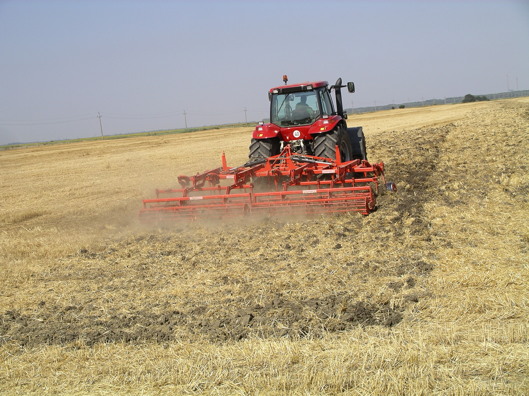
Soil tillage with chisel, non-inversion of furrow, 28 cm depth of tillage implemented.
2.2 技术的详细说明
说明:
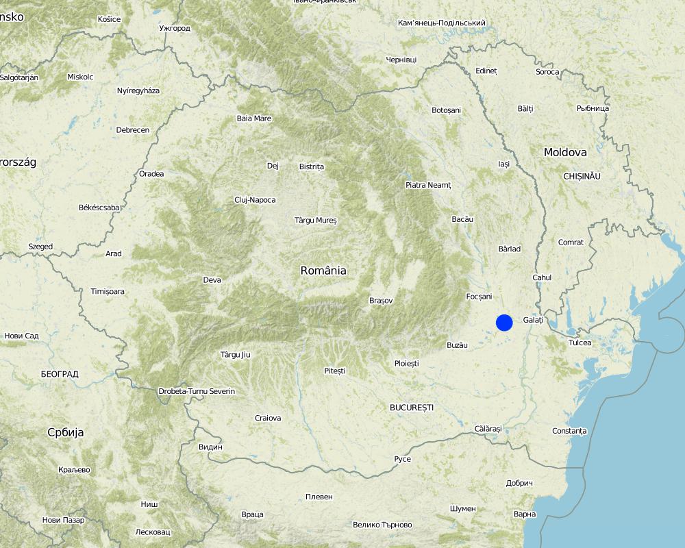
The technology is applied in Braila region and is located in north-eastern part of Romanian Plain. It has an agricultural area of 387,646 ha (of which 350,001 ha are arable land), and has specific geomorphologic, hydrological and climatic conditions which need to use ameliorative agricultural systems. Within Braila County are distinguished the following relief units: Calmatui Plain, part of the Braila Plain (51% from County area) and the Floodplains of Danube (Big Island of Braila), Siret, Buzau and Calmatui rivers (49% from County area).
Braila Plain is characterized by a specific micro-relief of Baragan type with large floodplains, poorly fragmented, with altitudes ranging between 20-25 m in the east part and 35-40 m to the west part, with soils mainly of chernozem type, formed on loess and loess deposits and which shows numerous small depression areas. Floodplains, areas adjacent to Danube, Siret, Buzau and Calmatui rivers are located at lower altitudes, ranging between 2-4 m and 13-15 m and are characterized by the presence of alluvial soils formed on river-limnic and alluvial deposits, with alternating of layers with different textures. According to United Nations Convention to Combat Desertification, Braila County is located in arid region with an average annual temperature of 10.9°C, long-term average annual precipitations (P) of 447 mm, potential evapotranspiration (ETP) of 705 mm (750-800 mm in dry years) and an average climatic water deficit of 258 mm (350-400 mm in dry years). The biophysical aridity index (P/ETP = 0.50-0.65) places the Braila region in area with moderate risk to desertification. Both intensive and extensive farming systems are practiced within Braila County. Intensive agriculture, characterized by high inputs and yield levels, is realized on large vegetal farms. On the other hand, extensive agriculture, with low input and yield levels, is practiced by farmers on small vegetal farms, and is so-called the semi-subsistent agriculture.
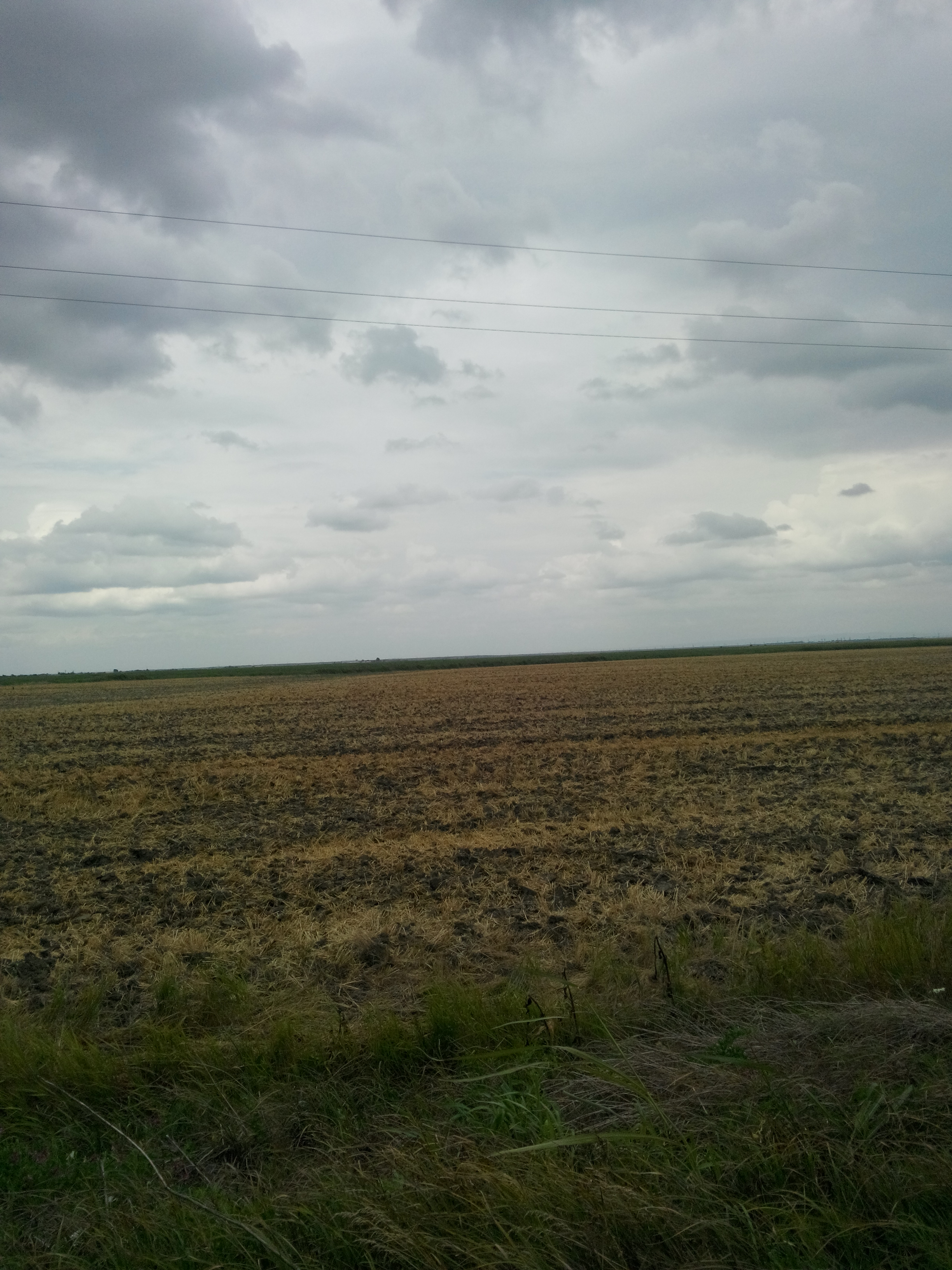
The chisel tillage technology is an agronomic measure, that is practiced on medium to large farms (from 50 ha to more than 1000 ha in size) within the North-Eastern part of the Romanian Plain. Over the past years some farmers have changed the farming system from conventional to reduced or conservation tillage. The most important characteristic of the technology is that the farmers do not invert the furrow during the main soil tillage operation. Also the soils are covered by plant residues (cereals straw and maize stalk chopped) on 30% of soil surface. In this way, in the long term, the soils remain protected from destructive factors, as e.g. erosive rainfalls, increases soil water retention capacity, and with this water availability and infiltration rate increase. The technology is applied on arable land with annual crops. The advantage of the tillage by chisel is that it leaves a higher surface roughness and is less destructive to soil aggregates.
The technology is applied on flat Fluvisols and Chernozems. The soil depth is very deep, the texture is in the medium class within the whole profile and the organic matter content is in medium range (1-3 %). The technology was firstly applied within a research project by the Agricultural Research and Development Station of Braila (ARDS Braila) and later was adopted by some land users within the area. The chisel equipment is usually bought by land users which have big vegetal farms. However, the equipment may be borrowed/leased by other land users from neighborhood.
In the land user's view, the strengths of the technology are as follows: positive effects on soil structure, biodiversity and soil water conservation, is a simple agricultural technique. In addition, the weaknesses of the technology reported by the land user might be: high investment costs for buying new agricultural machinery which can be met by renting from other farmers/agricultural contractors, new technology requires greater skill of the farmer which can be countered by further education and training, and sometimes soil surface neuniformity which can be prevented by additional tillage.
2.3 技术照片
媒体库
2.5 已应用该技术的、本评估所涵盖的国家/地区/地点
国家:
罗马尼亚
区域/州/省:
Braila
有关地点的进一步说明:
Braila
具体说明该技术的分布:
- 均匀地分布在一个区域
如果不知道精确的区域,请注明大致覆盖的区域:
- < 0.1 平方千米(10 公顷)
注释:
Documentation of the technology is based on examination of field plots tilled by chisel smaller than 0.1 km2.
Map
×2.6 实施日期
如果不知道确切的年份,请说明大概的日期:
- 10-50年前
2.7 技术介绍
详细说明该技术是如何引入的:
- 在实验/研究期间
注释(项目类型等):
The technology was firstly implemented in the early 2000's and described by the Agricultural Research and Development Station of Braila (ARDS Braila) which is subordinated to the Academy of Agricultural and Forestry Sciences. The station ARDS Braila conducts research and development in the following subjects: irrigation systems, agricultural technologies and improvement and reclamation of salted soils.
3. SLM技术的分类
3.1 该技术的主要目的
- 减少、预防、恢复土地退化
- 保持/提高生物多样性
- 适应气候变化/极端天气及其影响
3.2 应用该技术的当前土地利用类型

农田
- 一年一作
年作 - 具体指明作物:
- 谷物类 - 玉米
- 谷类 - 小麦(冬季)
- 油料作物 - 向日葵、菜籽、其他
每年的生长季节数:
- 1
注释:
Main crops (cash and food crops): winter wheat, maize, sunflower
3.4 供水
该技术所应用土地的供水:
- 混合雨水灌溉
3.5 该技术所属的SLM组
- 最小的土壤扰动
3.6 包含该技术的可持续土地管理措施

农艺措施
- A3:土壤表面处理
A3:区分耕作制度:
A 3.2: Reduced tillage (> 30% soil cover)
3.7 该技术强调的主要土地退化类型

物理性土壤退化
- Pu:由于其他活动而导致生物生产功能的丧失
注释:
Physical soil deterioration due to soil structure destruction.
3.8 防止、减少或恢复土地退化
具体数量名该技术与土地退化有关的目标:
- 减少土地退化
4. 技术规范、实施活动、投入和成本
4.1 该技术的技术图纸
技术规范(与技术图纸相关):
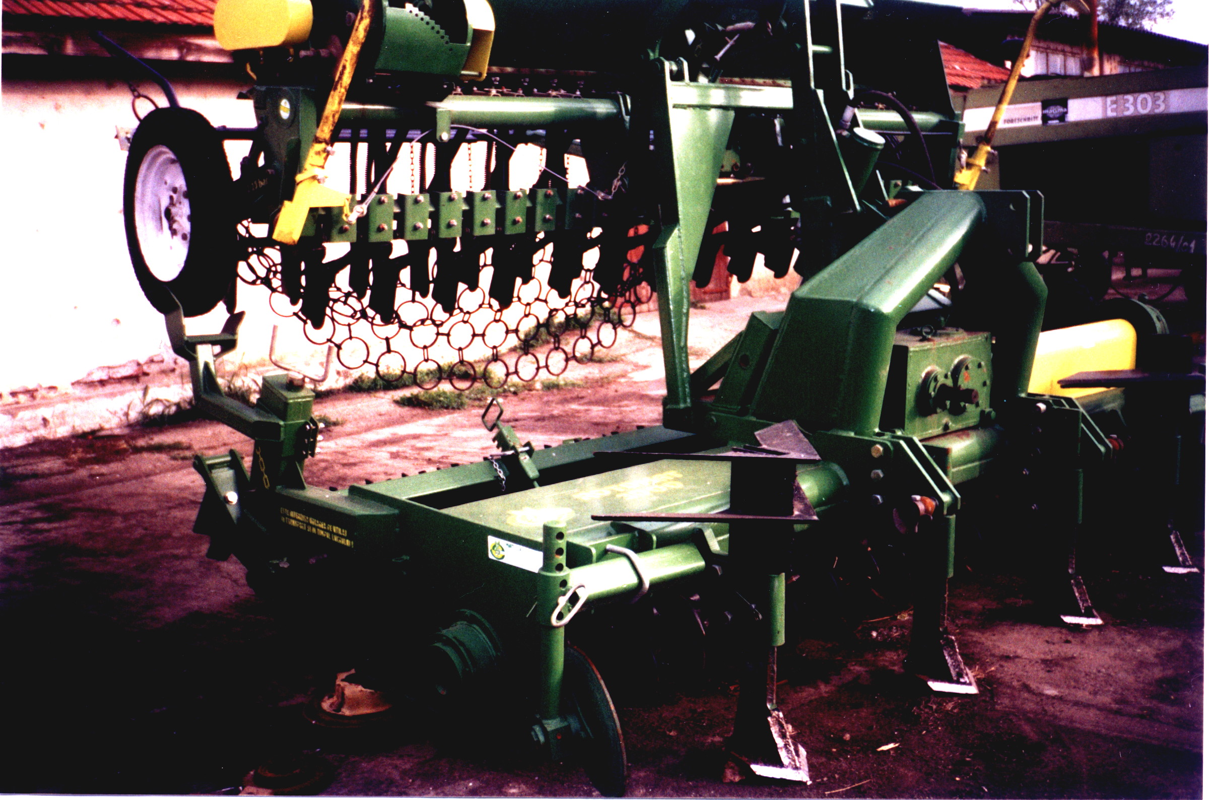
Soil tillage by chisel is done usually by two passes (one pass replace the ploughing and the second pass is done before plant sowing). The main advantage of this technology is that after plant sowing, around 30 % of the soil surface is covered by plant residues from the previous crop which were left on the soil surface. In this way, the water is preserved in soil and the infiltration rate is improved. Also the soil loosening may be done on the whole soil rooting depth.
Dimensions of the chisel implements are as follows: working width - 4 m; number of implements: 13; working depth: 15 - 40 cm; the implement slope angle: 27 degrees; the distance between implements: 30 cm.
4.2 有关投入和成本计算的一般信息
具体说明成本和投入是如何计算的:
- 每个技术区域
注明尺寸和面积单位:
1 hectare
具体说明成本计算所用货币:
- 美元
如相关,注明美元与当地货币的汇率(例如1美元=79.9巴西雷亚尔):1美元=:
4.12
注明雇用劳工的每日平均工资成本:
17.60 USD
4.4 技术建立所需要的费用和投入
注释:
No initial investment needed, as for the machinery land users are working with agricultural contractors from the neighboring area or other land users that own the equipment.
4.5 维护/经常性活动
| 活动 | 时间/频率 | |
|---|---|---|
| 1. | non-inversion tillage by chisel | annually |
4.6 维护/经常性活动所需要的费用和投入(每年)
| 对投入进行具体说明 | 单位 | 数量 | 单位成本 | 每项投入的总成本 | 土地使用者承担的成本% | |
|---|---|---|---|---|---|---|
| 劳动力 | driving tractor with chisel implement | person-days | 0.5 | 17.6 | 8.8 | 100.0 |
| 设备 | chisel plough machinery | machine-hours | 3.0 | 20.2 | 60.6 | 100.0 |
| 技术维护所需总成本 | 69.4 | |||||
| 技术维护总成本,美元 | 16.84 | |||||
4.7 影响成本的最重要因素
描述影响成本的最决定性因素:
Costs are mostly affected by input costs (e.g. seeds, biocides). Costs do not include chisel equipment because the farmer rely on borrowing/leasing the equipment from other land users or agricultural contractors from the neighboring area.
5. 自然和人文环境
5.1 气候
年降雨量
- < 250毫米
- 251-500毫米
- 501-750毫米
- 751-1,000毫米
- 1,001-1,500毫米
- 1,501-2,000毫米
- 2,001-3,000毫米
- 3,001-4,000毫米
- > 4,000毫米
指定年平均降雨量(若已知),单位为mm:
447.00
农业气候带
- 半干旱
5.2 地形
平均坡度:
- 水平(0-2%)
- 缓降(3-5%)
- 平缓(6-10%)
- 滚坡(11-15%)
- 崎岖(16-30%)
- 陡峭(31-60%)
- 非常陡峭(>60%)
地形:
- 高原/平原
- 山脊
- 山坡
- 山地斜坡
- 麓坡
- 谷底
垂直分布带:
- 0-100 m a.s.l.
- 101-500 m a.s.l.
- 501-1,000 m a.s.l.
- 1,001-1,500 m a.s.l.
- 1,501-2,000 m a.s.l.
- 2,001-2,500 m a.s.l.
- 2,501-3,000 m a.s.l.
- 3,001-4,000 m a.s.l.
- > 4,000 m a.s.l.
说明该技术是否专门应用于:
- 不相关
5.3 土壤
平均土层深度:
- 非常浅(0-20厘米)
- 浅(21-50厘米)
- 中等深度(51-80厘米)
- 深(81-120厘米)
- 非常深(> 120厘米)
土壤质地(表土):
- 中粒(壤土、粉土)
土壤质地(地表以下> 20厘米):
- 中粒(壤土、粉土)
表土有机质:
- 中(1-3%)
5.4 水资源可用性和质量
地下水位表:
5-50米
地表水的可用性:
中等
水的盐度有问题吗?:
否
该区域正在发生洪水吗?:
否
5.5 生物多样性
物种多样性:
- 中等
栖息地多样性:
- 中等
5.6 应用该技术的土地使用者的特征
定栖或游牧:
- 定栖的
生产系统的市场定位:
- 混合(生计/商业)
非农收入:
- 低于全部收入的10%
相对财富水平:
- 平均水平
个人或集体:
- 个人/家庭
机械化水平:
- 机械化/电动
性别:
- 男人
土地使用者的年龄:
- 中年人
说明土地使用者的其他有关特征:
The technology was firstly implemented by the Agricultural Research and Development Station of Braila.
5.7 应用该技术的土地使用者使用的平均土地面积
- < 0.5 公顷
- 0.5-1 公顷
- 1-2 公顷
- 2-5公顷
- 5-15公顷
- 15-50公顷
- 50-100公顷
- 100-500公顷
- 500-1,000公顷
- 1,000-10,000公顷
- > 10,000公顷
这被认为是小规模、中规模还是大规模的(参照当地实际情况)?:
- 大规模的
5.8 土地所有权、土地使用权和水使用权
土地所有权:
- 州
- 个人,未命名
土地使用权:
- 租赁
5.9 进入服务和基础设施的通道
健康:
- 贫瘠
- 适度的
- 好
教育:
- 贫瘠
- 适度的
- 好
技术援助:
- 贫瘠
- 适度的
- 好
就业(例如非农):
- 贫瘠
- 适度的
- 好
市场:
- 贫瘠
- 适度的
- 好
能源:
- 贫瘠
- 适度的
- 好
道路和交通:
- 贫瘠
- 适度的
- 好
饮用水和卫生设施:
- 贫瘠
- 适度的
- 好
金融服务:
- 贫瘠
- 适度的
- 好
6. 影响和结论性说明
6.1 该技术的现场影响
社会经济效应
生产
土地管理
注释/具体说明:
The main advantage of the soil tillage by chisel is that the energy consumption is reduced, especially the fuel and labour are reduced.
收入和成本
农业投入费用
注释/具体说明:
The chisel equipments are expensive.
社会文化影响
SLM/土地退化知识
注释/具体说明:
Knowledge about this technology can be also obtained by farmers from the Agricultural Research and Development Station of Braila .
生态影响
土壤
土壤水分
注释/具体说明:
The plant residues from soil surface prevent the soil water loss by evaporation.
土壤有机物/地下C
注释/具体说明:
Leaving the plant residues from the previous crop at the soil surface can improve the soil organic matter content.
生物多样性:植被、动物
有益物种
注释/具体说明:
Leaving the plant residues from the previous crop at the soil surface has beneficial impact on soil fauna.
6.2 该技术的场外影响已经显现
风力搬运沉积物
6.3 技术对渐变气候以及与气候相关的极端情况/灾害的暴露和敏感性(土地使用者认为的极端情况/灾害)
渐变气候
渐变气候
| 季节 | 增加或减少 | 该技术是如何应对的? | |
|---|---|---|---|
| 年温度 | 增加 | 好 | |
| 年降雨量 | 减少 | 好 |
气候有关的极端情况(灾害)
气象灾害
| 该技术是如何应对的? | |
|---|---|
| 局地暴雨 | 好 |
气候灾害
| 该技术是如何应对的? | |
|---|---|
| 干旱 | 好 |
6.4 成本效益分析
技术收益与技术建立成本相比如何(从土地使用者的角度看)?
短期回报:
稍微积极
长期回报:
积极
技术收益与技术维护成本/经常性成本相比如何(从土地使用者的角度看)?
短期回报:
中性/平衡
长期回报:
稍微积极
6.5 技术采用
- 1-10%
在所有采用这项技术的人当中,有多少人是自发的,即未获得任何物质奖励/付款?:
- 91-100%
注释:
One land user has implemented the technology voluntary.
6.6 适应
最近是否对该技术进行了修改以适应不断变化的条件?:
否
6.7 该技术的优点/长处/机会
| 土地使用者眼中的长处/优势/机会 |
|---|
| The technology has positive effects on soil structure and biodiversity. |
| The technology has positive effects on soil water conservation. |
| The technology is a simple agricultural technique. |
| 编制者或其他关键资源人员认为的长处/优势/机会 |
|---|
| The technology can be adapted and used under climate changes extremes. |
6.8 技术的弱点/缺点/风险及其克服方法
| 土地使用者认为的弱点/缺点/风险 | 如何克服它们? |
|---|---|
| High investment costs for buying new agricultural machinery | agricultural contractors |
| New technology requires greater skill of the farmer | education, training |
| Sometimes soil surface neuniformity | additional tillage |
| 编制者或其他关键资源人员认为的弱点/缺点/风险 | 如何克服它们? |
|---|---|
| The farmer's mentality from local area towards conservation agriculture is constraining the adoption of the system by other farmers. | continuous demonstration and dissemination about benefits of the technology |
7. 参考和链接
7.1 信息的方法/来源
- 实地考察、实地调查
2
- 与土地使用者的访谈
2
- 根据报告和其他现有文档进行编译
1
(现场)数据是什么时候汇编的?:
29/09/2017
7.2 参考可用出版物
标题、作者、年份、ISBN:
"Lucrarea conservativa a solului intre traditie si perspectiva in agricultura durabila" (Conservative tillage of soil between tradition and perspective in sustainable agriculture), Elisabeta Dumitru et. al., 2005, ISBN 973-86587-9-9.
链接和模块
全部展开 全部收起链接
无链接
模块
无模块