Ecosystem-wide seasonal grazing management in community land [肯尼亚]
- 创建:
- 更新:
- 编制者: Peter Tyrrell
- 编辑者: Enoch Mobisa, Lance W. Robinson
- 审查者: Donia Mühlematter, Hanspeter Liniger, Rima Mekdaschi Studer, Alexandra Gavilano
technologies_3372 - 肯尼亚
查看章节
全部展开 全部收起1. 一般信息
1.2 参与该技术评估和文件编制的资源人员和机构的联系方式
有助于对技术进行记录/评估的项目名称(如相关)
Book project: Guidelines to Rangeland Management in Sub-Saharan Africa (Rangeland Management)1.3 关于使用通过WOCAT记录的数据的条件
编制者和关键资源人员接受有关使用通过WOCAT记录数据的条件。:
是
1.4 所述技术的可持续性声明
这里所描述的技术在土地退化方面是否存在问题,导致无法被认为是一种可持续的土地管理技术?:
否
1.5 参考关于SLM方法(使用WOCAT记录的SLM方法)的调查问卷
Community-based rangeland management in the southern Kenyan rangelands [肯尼亚]
Olkiramatian Group Ranch strengthened the capacity of its community governance structures and began to engage in more rigorous implementation of seasonal grazing plans. This was based on traditional ecological knowledge and rangeland management practices. The group ranch incorporated conservation, research, and joint rangeland management planning with neighboring communities.
- 编制者: Lance W. Robinson
2. SLM技术的说明
2.1 技术简介
技术定义:
Livestock movements are managed through community governance systems to maintain spatial and temporal heterogeneity of pasture, creating a gradient of quality and quantity of pasture across the landscape. This is achieved through clearly designated seasonal grazing areas for livestock and tight controls on settlement areas, grazing patterns and water points. In addition, at the individual herder level, traditional ecological knowledge plays a strong role in the decisions made to improve livestock production
2.2 技术的详细说明
说明:
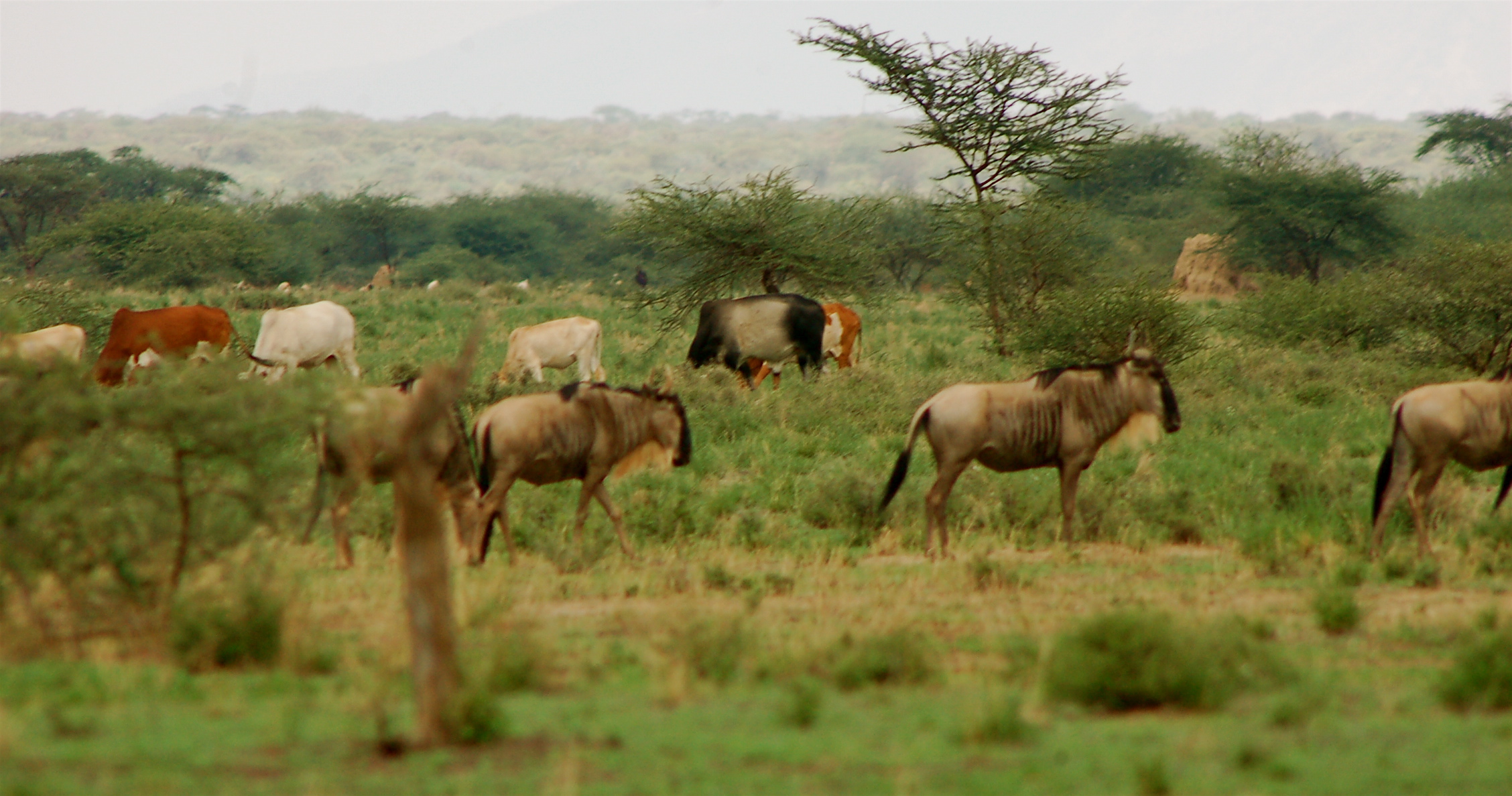
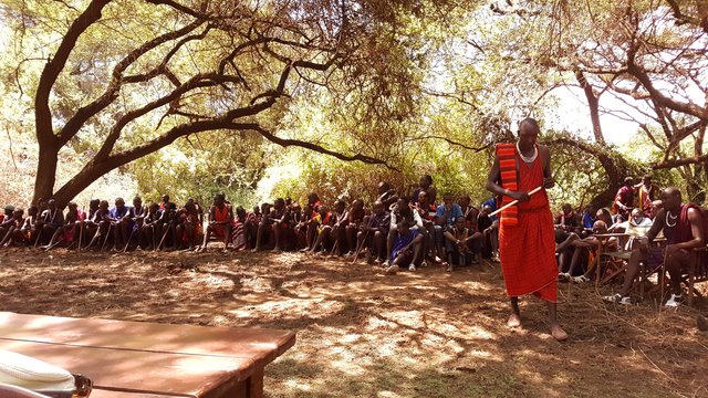
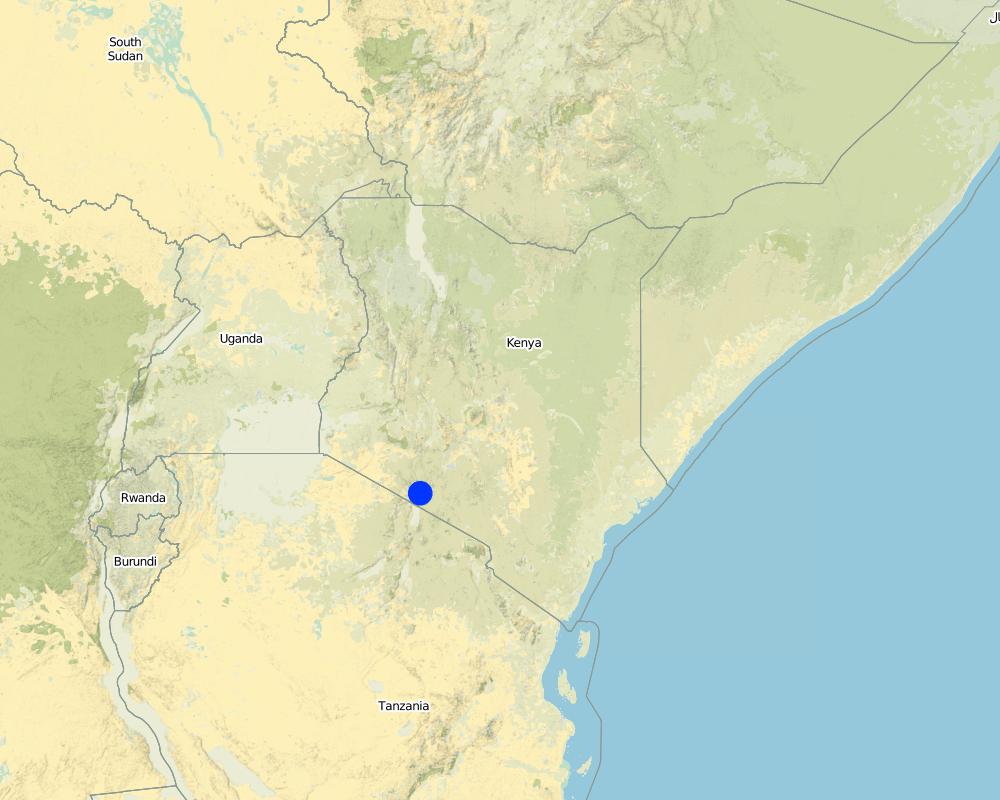
This technology is applied in the South Rift Valley, Kenya, across a semi-arid landscape, with erratic rainfall averaging 400-600 mm per annum. Water availability is an issue. The perennial Ewaso Ngiro South river flows through the Shompole swamp, a vital drought refuge for livestock and wildlife, before ending up in Lake Natron. The area, roughly 1000 km2, is covered by two group ranches, Olkiramatian and Shompole, which are managed as a single ecological unit. A group ranch is a jointly owned freehold land title given to the customary occupants of communal lands. The total number of occupants of both ranches number roughly 20,000 people, with the majority belonging to the Maasai ethnic group. The ranches have not been subdivided and are not fully sedentary, unlike many other areas of southern Kenya.
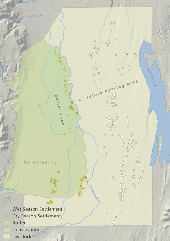
There is a long history of co-existence of wildlife and livestock in Maasialand. In Olkiramatian and Shompole seasonal livestock movements and herding practices are formalized by group ranch grazing plans governed by local committees. The wet season grazing areas are termed “livestock rearing zones”. The dry season grazing areas have been retained as “grass banks” for livestock, and since the early 2000s, have been used additionally as wildlife conservancies for ecotourism (see figure below). Livestock rearing occurs to the east of the Ewaso Ngiro river; grass banks and the wildlife conservancy to the west. Grazing committees from both group ranches manage livestock access to certain areas, with the conservancy (grass bank) rested during the wet season of up to six months. When grazing is permitted in the conservancy, as the dry season progresses, temporary settlements are limited to an area called the “buffer zone”. Livestock must then move into the conservancy from the buffer zones to access this late season grazing. The “livestock rearing zone” is permanently settled and grazed year-round. Within each zone there are small “Olopololis” (grass banks of a few hectares), situated near individual settlements and used to maintain higher quality pasture for weak and young animals. This management strategy ensures that the dry season grazing area is rested during the rains, and it helps to maintain consistently higher biomass and taller grass than that of the wet season grazing area. The higher biomass also corresponds to a rainfall gradient running from the Nguruman Escarpment edge in the western extremity of the group ranches to the dry central rift valley floor in the east. The biomass in the dry season area is used by both livestock and wildlife grazers during the late dry season and in droughts. The grass bank is only grazed out during prolonged dry periods. The Maasai employ a strategy of using the shorter milk-producing grasses of the livestock areas during the rains and the coarser grasses in the grass banks for the dry seasons. The shorter wet season pastures have a higher nutrient content and greater digestibility than the grass bank: this is very important for lactating females. The grass is kept short from both grazing by livestock during the growing seasons and due to intrinsic differences caused by shallower soils and lower rainfall in these grazing areas.
Within this broader governance framework and control of grazing areas, individual decision making is also permitted within these controlled areas. This allows herders to manage livestock to improve production in relation to each herd. For example, individuals might split the herd to take advantage of different energy and nutrient requirements of lactating females, bulls, and calves.
This maintenance and exploitation of forage heterogeneity is vital to the productivity and resilience of the landscape, and this heterogeneity exists at multiple scales, with the major differences existing between the grazing areas, but also smaller difference within them. Resource heterogeneity facilitates wildlife-livestock coexistence. This heterogeneity creates a matrix of varying quality and quantity of forage. Wildlife species have different metabolic requirements and diets, and this varied base ensures that a diverse wild ungulate population is maintained year-round. Late season forage boosts the resilience of wildlife during extreme events. This technology requires a governance structure that is both responsive to the changing ecological conditions and able to build consensus and enforce grazing management.
2.3 技术照片
媒体库
2.5 已应用该技术的、本评估所涵盖的国家/地区/地点
国家:
肯尼亚
区域/州/省:
Kajiado
有关地点的进一步说明:
Olkiramatian
具体说明该技术的分布:
- 均匀地分布在一个区域
如果不知道精确的区域,请注明大致覆盖的区域:
- 100-1,000 平方千米
注释:
The technology formerly worked across the entirety of Maasailand (50,000 km2). However, breakdowns in social structures, culture, and governance arrangements have led to wide-scale losses in traditional grazing management. Olkiramtian and its neighbor Shompole, are two of the few communities managing to graze in such a way to maintain and capitalize on the spatial-temporal heterogeneity of forage resources through merging traditional and modern institutions.
Map
×2.6 实施日期
注明实施年份:
2004
2.7 技术介绍
详细说明该技术是如何引入的:
- 作为传统系统的一部分(> 50 年)
注释(项目类型等):
The grazing management system is adapted from traditional grazing management of Maasai pastoralists.
3. SLM技术的分类
3.1 该技术的主要目的
- 改良生产
- 减少、预防、恢复土地退化
- 保护生态系统
- 保持/提高生物多样性
- 减缓气候变化及其影响
- 创造有益的经济影响
3.2 应用该技术的当前土地利用类型

牧场
粗放式放牧:
- 半游牧畜牧业
动物类型:
- 山羊
- 绵羊
- cattle
注释:
Number of growing seasons per year: 2
Long rains fall between April - June; Short rains fall between October - December.
Livestock density: Cattle 6.2 / km2; Shoats 52.2 / km2
3.4 供水
该技术所应用土地的供水:
- 雨养
注释:
The area is semi-arid and receives rainfall erratically, both in space and time, in a bi-modal pattern.
3.5 该技术所属的SLM组
- 畜牧业和牧场管理
3.6 包含该技术的可持续土地管理措施

管理措施
- M2:改变管理/强度级别
- M3:根据自然和人文环境进行布局
- M4:活动时间安排的重大变化
3.7 该技术强调的主要土地退化类型

土壤水蚀
- Wt:表土流失/地表侵蚀

生物性退化
- Bc:植被覆盖的减少
- Bh:栖息地丧失
- Bq:数量/生物量减少
- Bs:质量和物种组成/多样性的下降
3.8 防止、减少或恢复土地退化
具体数量名该技术与土地退化有关的目标:
- 防止土地退化
注释:
Although in general, this technology aims to prevent land degradation through the maintenance of forage cover; localized degradation does occur across different locations within the landscape, especially in areas of highest livestock impact, such as water points and settlement areas.
4. 技术规范、实施活动、投入和成本
4.1 该技术的技术图纸
技术规范(与技术图纸相关):
The drawing shows the management units used in this seasonally structured grazing management system. The livestock rearing zone, to the east of the Ewaso Nyiro river, is permanently settled and is grazed heavily during the wet season (April - July). During this time herders utilize the short, nutritious grasses in this low biomass area. As forage biomass begins to reduce the community grazing committees meet to discuss the opening of settlements to the west of the Ewaso Nyiro river. This decision is made using traditional ecological knowledge, comparing available forage biomass and the numbers of livestock to previous years and past experiences. Once the grazing has been opened to the west of the river people may settle within the buffer zone. This limits direct access to the higher biomass areas within the conservancy and grass banks, and increases the length of travel for each herd every day, in an effort to preserve forage for longer. Once forage has been depleted in the buffer zones and the periphery of the conservancies, the committees meet and allow access for herders into the conservation areas, which have tall, high biomass, but low-quality grazing. Often access to this area requires considerable distances to be walked by livestock. In recent years, adaptive management systems have led to the settlements within the south of the conservation area to be closed to preserve forage biomass within the swamp and conservation area for a longer period of time; and allow for recovery of partially degraded land.
作者:
Peter Tyrrell
日期:
01/02/2018
4.2 有关投入和成本计算的一般信息
具体说明成本和投入是如何计算的:
- 每个技术单元
指定单位:
The two group ranches
指定单位面积(如相关):
Approximately 1000km2
具体说明成本计算所用货币:
- 美元
注明雇用劳工的每日平均工资成本:
4
4.3 技术建立活动
注释:
No activities were required to establish this practice as it has been ongoing and builds on traditional management structures.
4.4 技术建立所需要的费用和投入
注释:
N/A
4.5 维护/经常性活动
| 活动 | 时间/频率 | |
|---|---|---|
| 1. | Management meetings | Seasonally |
4.6 维护/经常性活动所需要的费用和投入(每年)
注释:
The only real costs of this technology, which is different to any other form of grazing system, would be the cost of management through meetings. Otherwise the costs are just that of any other livestock production enterprise.
4.7 影响成本的最重要因素
描述影响成本的最决定性因素:
There are no or little costs to this technology, as it builds off structures of management which are already in place and work organically within the area.
5. 自然和人文环境
5.1 气候
年降雨量
- < 250毫米
- 251-500毫米
- 501-750毫米
- 751-1,000毫米
- 1,001-1,500毫米
- 1,501-2,000毫米
- 2,001-3,000毫米
- 3,001-4,000毫米
- > 4,000毫米
指定年平均降雨量(若已知),单位为mm:
400.00
有关降雨的规范/注释:
Highly variable rainfall both spatially and temporally. Annual average rainfall has a 33%CV.
注明所考虑的参考气象站名称:
Lale'enok Resource Centre
农业气候带
- 半干旱
- 干旱
5.2 地形
平均坡度:
- 水平(0-2%)
- 缓降(3-5%)
- 平缓(6-10%)
- 滚坡(11-15%)
- 崎岖(16-30%)
- 陡峭(31-60%)
- 非常陡峭(>60%)
地形:
- 高原/平原
- 山脊
- 山坡
- 山地斜坡
- 麓坡
- 谷底
垂直分布带:
- 0-100 m a.s.l.
- 101-500 m a.s.l.
- 501-1,000 m a.s.l.
- 1,001-1,500 m a.s.l.
- 1,501-2,000 m a.s.l.
- 2,001-2,500 m a.s.l.
- 2,501-3,000 m a.s.l.
- 3,001-4,000 m a.s.l.
- > 4,000 m a.s.l.
说明该技术是否专门应用于:
- 不相关
关于地形的注释和进一步规范:
This area lies at the bottom of the rift valley, with the Nguruman Escarpment and Loita Hills towering up to the west. This change in elevation ensures that there is fresh water reaching the area year round and that there is very late season forage available at higher altitudes if required.
5.3 土壤
平均土层深度:
- 非常浅(0-20厘米)
- 浅(21-50厘米)
- 中等深度(51-80厘米)
- 深(81-120厘米)
- 非常深(> 120厘米)
土壤质地(表土):
- 粗粒/轻(砂质)
- 中粒(壤土、粉土)
土壤质地(地表以下> 20厘米):
- 粗粒/轻(砂质)
- 中粒(壤土、粉土)
5.4 水资源可用性和质量
地下水位表:
> 50米
地表水的可用性:
匮乏/没有
水质(未处理):
不良饮用水(需要处理)
水的盐度有问题吗?:
否
该区域正在发生洪水吗?:
是
规律性:
偶然
关于水质和水量的注释和进一步规范:
Seasonal floods down the Ewaso Nyiro river provide an important water source for the Shompole Swamp. This swamp acts as an import drought refuge for livestock.
5.5 生物多样性
物种多样性:
- 高
栖息地多样性:
- 高
关于生物多样性的注释和进一步规范:
The area has an intact community of large herbivores, 21 species of carnivore and a growing population of elephants. This in part due to the habitat diversity and heterogeneity that has been maintained. Habitat diversity is facilitated by elevation changes up the Nguruman Escarpment, a variable rainfall gradient from East to West, the presence of Soda lakes, and the presence of perennial rivers. The area is also an Important Bird Area and is home to two community conservation areas. It holds some of the largest numbers of large mammals outside of government protected areas in Kenya.
5.6 应用该技术的土地使用者的特征
定栖或游牧:
- 半游牧的
生产系统的市场定位:
- 混合(生计/商业)
- 商业/市场
非农收入:
- 低于全部收入的10%
相对财富水平:
- 非常贫瘠
- 贫瘠
个人或集体:
- 个人/家庭
- 团体/社区
机械化水平:
- 手工作业
性别:
- 女人
- 男人
说明土地使用者的其他有关特征:
All ages are involved in this practice and all genders. It is a way of live using this management.
5.7 应用该技术的土地使用者使用的平均土地面积
- < 0.5 公顷
- 0.5-1 公顷
- 1-2 公顷
- 2-5公顷
- 5-15公顷
- 15-50公顷
- 50-100公顷
- 100-500公顷
- 500-1,000公顷
- 1,000-10,000公顷
- > 10,000公顷
这被认为是小规模、中规模还是大规模的(参照当地实际情况)?:
- 中等规模的
注释:
This land is managed under two community land titles. The management is at an intermediate scale as it does not address grazing management beyond the ecosystem boundary and across the greater landscape. This larger-scale approach is, however, a critical component of a larger landscape management system which was previously governed under Maasai culture.
5.8 土地所有权、土地使用权和水使用权
土地所有权:
- 社区/村庄
土地使用权:
- 社区(有组织)
用水权:
- 社区(有组织)
- Traditional methods of water management through comittees exists in some areas. In other area the creation of Water Resource Users Associations has begun to manage water.
注释:
The land is owned under two community titles. The land-use is restricted to members of the group ranches, who may allow for reciprocal grazing rights to be exchanged with neighbouring communities.
5.9 进入服务和基础设施的通道
健康:
- 贫瘠
- 适度的
- 好
教育:
- 贫瘠
- 适度的
- 好
技术援助:
- 贫瘠
- 适度的
- 好
就业(例如非农):
- 贫瘠
- 适度的
- 好
市场:
- 贫瘠
- 适度的
- 好
能源:
- 贫瘠
- 适度的
- 好
道路和交通:
- 贫瘠
- 适度的
- 好
饮用水和卫生设施:
- 贫瘠
- 适度的
- 好
金融服务:
- 贫瘠
- 适度的
- 好
6. 影响和结论性说明
6.1 该技术的现场影响
社会经济效应
生产
饲料生产
注释/具体说明:
This is in contrast to areas without seasonal grazing management.
饲料质量
注释/具体说明:
This management system works best to preserve lower quality higher biomass fodder. Quality may not increase dramatically, but the creation of short areas of well-fertilized grass near settlements may increase the local quality of fodder during the wet season.
生产故障风险
注释/具体说明:
In comparison to other systems the preservation of late season grazing is crucial in preventing complete losses of livestock during droughts.
社会文化影响
文化机会
注释/具体说明:
Management of land in this manner relies on traditional ecological knowledge for both individual and community decision making. This is dependent on cultural values and understanding, and underpins grazing management in Maasai society.
生态影响
生物多样性:植被、动物
植被覆盖
注释/具体说明:
This method increase vegetation cover by maintaining heterogeneity of forage resources across the landscape, and resting pasture seasonally to allow for vegetation regrowth.
生物量/地上C
注释/具体说明:
Late season forage available. Recovery and rest allows for greater productivity and rainfall use efficiency.
动物多样性
注释/具体说明:
Maintenance of spatial and temporal heterogeneity of forage resources ensures that wildlife species have access to the variable resources that they require over time.
6.3 技术对渐变气候以及与气候相关的极端情况/灾害的暴露和敏感性(土地使用者认为的极端情况/灾害)
渐变气候
渐变气候
| 季节 | 增加或减少 | 该技术是如何应对的? | |
|---|---|---|---|
| 年降雨量 | 减少 | 适度 | |
| 季雨量 | 湿季/雨季 | 减少 | 适度 |
气候有关的极端情况(灾害)
气候灾害
| 该技术是如何应对的? | |
|---|---|
| 干旱 | 好 |
6.4 成本效益分析
技术收益与技术建立成本相比如何(从土地使用者的角度看)?
短期回报:
非常积极
长期回报:
非常积极
技术收益与技术维护成本/经常性成本相比如何(从土地使用者的角度看)?
短期回报:
非常积极
长期回报:
非常积极
注释:
No costs to establish and low direct cost of management actions.
6.5 技术采用
- > 50%
在所有采用这项技术的人当中,有多少人是自发的,即未获得任何物质奖励/付款?:
- 91-100%
注释:
This system is adopted by most land-users because of the governance systems in place. There are some individuals who may not choose to abide by the rules set out by the committees, but a combination of peer pressure; traditional curses; and fines usually prevent this.
6.6 适应
最近是否对该技术进行了修改以适应不断变化的条件?:
是
若是,说明它适应了哪些变化的条件:
- 气候变化/极端气候
具体说明技术的适应性(设计、材料/品种等):
The management is constantly being adapted based on the prevailing ecological conditions. In 2015, over fifty settlements were closed by the community grazing and group ranch committee within the dry season grazing area to allow for pasture regeneration and to consolidate preservation of the dry season grass bank.
6.7 该技术的优点/长处/机会
| 土地使用者眼中的长处/优势/机会 |
|---|
| This technology stems from a community based and is not imposed from a top-down perspective, and tries to create consensus among resource users. |
| Allows individual flexibility within the broader grazing structure so that people can manage livestock within their own objectives. |
| This technology provides forage for livestock into the dry season and drought. |
| 编制者或其他关键资源人员认为的长处/优势/机会 |
|---|
| Management in this way also replicates the methodologies used for land management for thousands of years by pastoral people and helps to generate an enabling environment for the coexistence of wildlife, domestic livestock, and people. |
| Ensures that pasture is rested during the growing season within the dry season grazing areas, so that root mass can be established and to ensure grass seed production. |
6.8 技术的弱点/缺点/风险及其克服方法
| 土地使用者认为的弱点/缺点/风险 | 如何克服它们? |
|---|---|
| Exploitation of the system by elites in charge of management decisions, allowing their livestock to access preferential grazing, which may not represent the needs of all groups. | Ensure credible management structures in place; with the new community land act, this should encourage greater equity in decision making. |
| Preventing settlement in areas of traditional occupation by certain households. |
| 编制者或其他关键资源人员认为的弱点/缺点/风险 | 如何克服它们? |
|---|---|
| Lack of focus on a production based system and income generation through livestock sales. | Create and enabling environment for change, through market improvement and learning exchanges. |
| Lack of resting and recovery of forage in the wet season grazing area. | Rotate and rest wet season pasture for a few weeks during the growing period, potentially through grazing in the dry season reserve for a longer period. |
7. 参考和链接
7.1 信息的方法/来源
- 实地考察、实地调查
Living in the area for the last four years.
- 根据报告和其他现有文档进行编译
(现场)数据是什么时候汇编的?:
01/01/2017
7.3 链接到网络上的相关信息
标题/说明:
Seasonal movements of wildlife and livestock in a heterogeneous pastoral landscape: Implications for coexistence and community based conservation
URL:
http://www.sciencedirect.com/science/article/pii/S2351989417301075
链接和模块
全部展开 全部收起链接
Community-based rangeland management in the southern Kenyan rangelands [肯尼亚]
Olkiramatian Group Ranch strengthened the capacity of its community governance structures and began to engage in more rigorous implementation of seasonal grazing plans. This was based on traditional ecological knowledge and rangeland management practices. The group ranch incorporated conservation, research, and joint rangeland management planning with neighboring communities.
- 编制者: Lance W. Robinson
模块
无模块