Double Basin Masonry Check Dam [埃塞俄比亚]
- 创建:
- 更新:
- 编制者: GERBA LETA
- 编辑者: Torben Helbig, Noel Templer, Tabitha Nekesa, Ahmadou Gaye, Siagbé Golli
- 审查者: William Critchley, Rima Mekdaschi Studer, Sally Bunning
NA
technologies_6716 - 埃塞俄比亚
查看章节
全部展开 全部收起1. 一般信息
1.2 参与该技术评估和文件编制的资源人员和机构的联系方式
关键资源人
SLM专业人员:
Abdi Amir
Dry valley Rehabilitation and Productive Use (DVRPU) project of the GIZ
埃塞俄比亚
有助于对技术进行记录/评估的项目名称(如相关)
Soil protection and rehabilitation for food security (ProSo(i)l)有助于对技术进行记录/评估的机构名称(如相关)
Alliance Bioversity and International Center for Tropical Agriculture (Alliance Bioversity-CIAT) - 肯尼亚1.3 关于使用通过WOCAT记录的数据的条件
编制者和关键资源人员接受有关使用通过WOCAT记录数据的条件。:
是
1.4 所述技术的可持续性声明
这里所描述的技术在土地退化方面是否存在问题,导致无法被认为是一种可持续的土地管理技术?:
否
注释:
The Check Dam helps to arrest the runoff of flood and rehabilitate the gully development.
1.5 参考关于SLM方法(使用WOCAT记录的SLM方法)的调查问卷
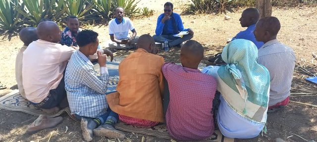
Participatory Rehabilitation of Dry Valleys [埃塞俄比亚]
Participatory rehabilitation and productive use of dry valleys is an approach employed to rehabilitate degraded and degradable land. It is operationalised through the Lowland Soil Rehabilitation Project with local development partners from kebele, district, regional agricultural bureaus, and other relevant stakeholders.
- 编制者: GERBA LETA
2. SLM技术的说明
2.1 技术简介
技术定义:
A double basin masonry check dam is a physical structure that helps to stop gully formation or further development of gullies in dry valleys. It rehabilitates small to a medium-sized deep gullies that are eating into the heart of adjacent land.
2.2 技术的详细说明
说明:
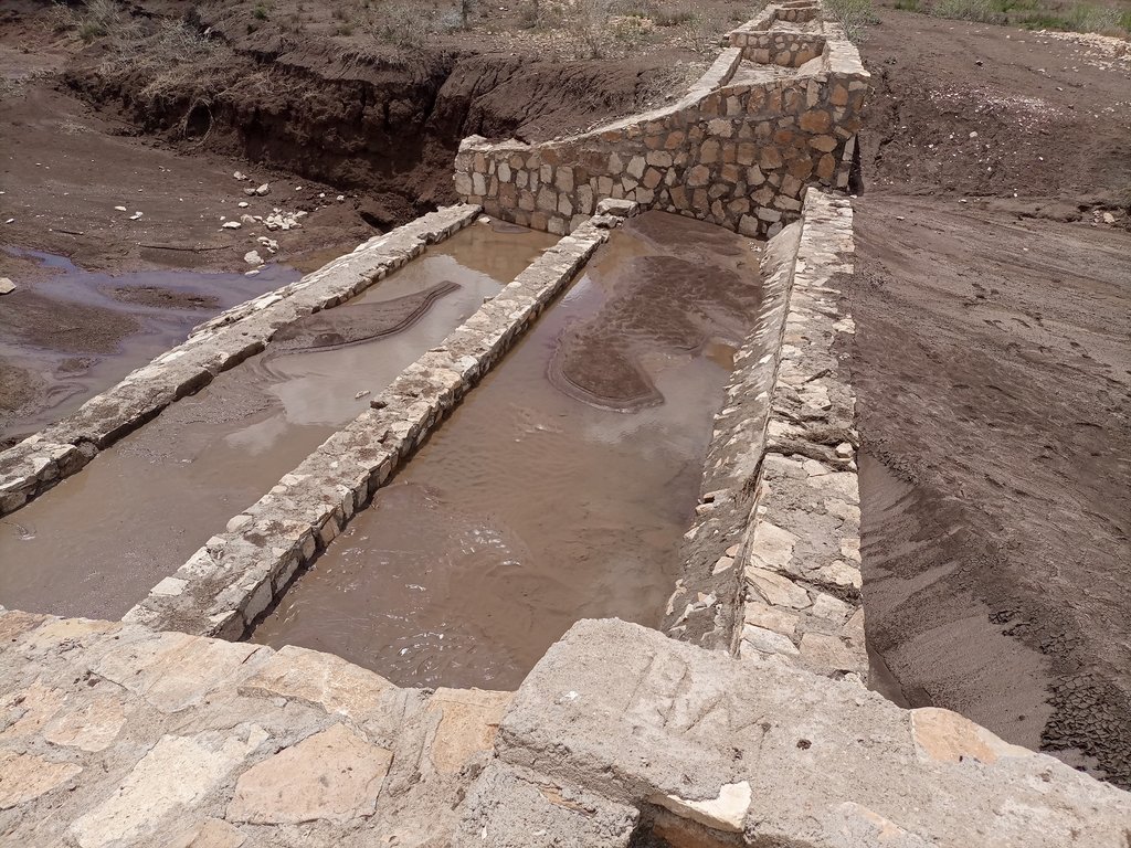
A “double basin masonry check dam” is a structure built in a narrow gully or depression to stop further gully formation. It is made of stone, concrete, gabions and wooden bars and serves as a permanent barrier. In this particular site stone is used as the structure is masonry. The technology is applied in areas where there are concentrated flows of water or runoff. The double basin masonry check dam is sited across a slope or a deep gully to slow water flow and capture sediment from upstream in the basins and behind the structure, thereby preventing expansion of the gully. The width of a check dam is variable. This particular structure is 14 meter wide, three meters deep and about 52 meters long. By helping to fill up the gully with sediment, it leads to rehabilitation and makes productive use of the area for growing trees, forage, and other plants. Apart from reducing the speed of surface runoff, the structure also promotes water infiltration, and recharges the groundwater reserves in the aquifer.
The main inputs necessary to build the check dams are financial resources, technical skills, skilled and unskilled labour, and construction materials including sand, stone, cement, water and other materials. Furthermore, construction tools such as a theodolite, line level, string, hammers, spades, hoes, and other tools are essential for design & construction. Technical skills for designing and profiling, and further capacity-building training are essential also. Application of the technology is also supported by satellite image and ground truthing to ensure the precision of siting.
The agropastoralists in the dry basin areas are pleased to see a huge movement of the soil arrested by the structure. The reduced expansion of the gully into the heart of the farm and grazing lands raises hopes of their land become productive and remaining so for generations to come. This hope and expectation have motivated them to welcome the intervention and develop an understanding of the actual benefits accrued from it. This leads to their support for the construction efforts. The disadvantages are that the technology is labour and resource-intensive which can be unaffordable for resource-poor agropastoralist communities living in food-insecure areas where rainfall is unreliable. This may make the adoption of the technology difficult to establish and nurture on their own without outside support.
2.3 技术照片
关于照片的一般说明:
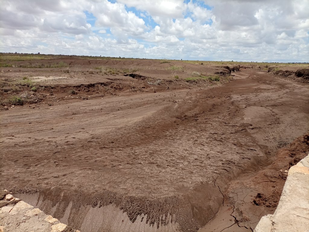
The photos display a large amount of sediment captured by a few days' shower post recurrent droughts experienced in the area over the last two to three years.
2.4 技术视频
注释、简短说明:
Video of the technology was not taken by this particular documentation exercise.
2.5 已应用该技术的、本评估所涵盖的国家/地区/地点
国家:
埃塞俄比亚
区域/州/省:
Somali
有关地点的进一步说明:
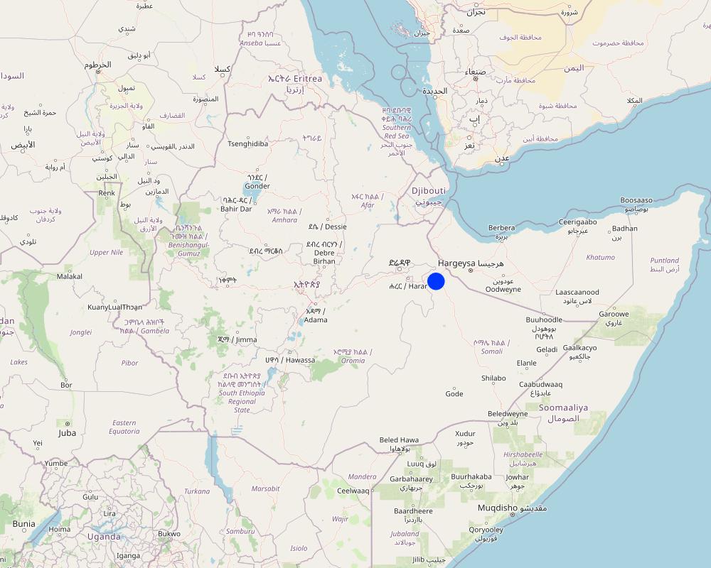
Hadow kebele of south Jigjiga district
具体说明该技术的分布:
- 适用于特定场所/集中在较小区域
技术现场是否位于永久保护区?:
否
注释:
Locating the check dam closer to each other may help to stop the damage of heavy and concentrated flood moving in the drainage basin.
Map
×2.6 实施日期
注明实施年份:
2021
2.7 技术介绍
详细说明该技术是如何引入的:
- 通过项目/外部干预
注释(项目类型等):
Capacity Development and Strengthening Drought Resilience (CDSDR) project of the GIZ in Somali Region.
3. SLM技术的分类
3.1 该技术的主要目的
- 减少、预防、恢复土地退化
- 保护生态系统
- 结合其他技术保护流域/下游区域
- 保持/提高生物多样性
- 降低灾害风险
3.2 应用该技术的当前土地利用类型
同一土地单元内混合使用的土地::
否
3.3 由于技术的实施,土地使用是否发生了变化?
由于技术的实施,土地使用是否发生了变化?:
- 否(继续问题3.4)
3.4 供水
该技术所应用土地的供水:
- 雨养
注释:
Rainfed is the type of water supply that often experiences erratic distribution characterized by the reception of lower amounts. Mostly characterized by erratic and erosive feature.
3.5 该技术所属的SLM组
- 畜牧业和牧场管理
- 横坡措施
- 集水
3.6 包含该技术的可持续土地管理措施

结构措施
- S6:墙、障碍物、栅栏、围墙
3.7 该技术强调的主要土地退化类型

土壤水蚀
- Wt:表土流失/地表侵蚀
- Wg:冲沟侵蚀/沟蚀
- Wm:块体运动/滑坡
3.8 防止、减少或恢复土地退化
具体数量名该技术与土地退化有关的目标:
- 减少土地退化
- 修复/恢复严重退化的土地
注释:
The technology stops the mass movement of soil and water. As a result, it reduces land degradation, rehabilitates the degraded dry valley, and makes the land available for productive uses.
4. 技术规范、实施活动、投入和成本
4.1 该技术的技术图纸
技术规范(与技术图纸相关):
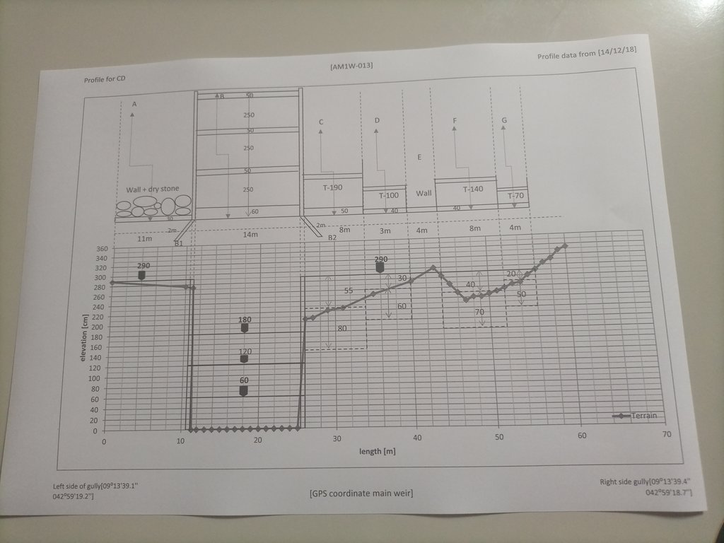
The design (layout - top view) and profile (lower view) of the technology is presented with universal units to clearly read and understand by the SLM experts or engineers. In addition, there are section drawings of the main weir and Bill of Quantity (BOQ).
作者:
Amir Abdi
日期:
14/12/2018
4.2 有关投入和成本计算的一般信息
具体说明成本和投入是如何计算的:
- 每个技术单元
指定单位:
check dam
指定单位面积(如相关):
14m*3m*52m =2184m3
具体说明成本计算所用货币:
- 美元
注明雇用劳工的每日平均工资成本:
8.5 - 16 USD based on their skills
4.3 技术建立活动
| 活动 | 时间(季度) | |
|---|---|---|
| 1. | Conduct rapid assessment and Surveillance of intervention site | During the off-season |
| 2. | Finalize site selection | ditto |
| 3. | Layout, Design and profiling works | |
| 4. | Identify and train masonry workers | During off-season |
| 5. | Material supply | |
| 6. | Start actual layout and excavation work | |
| 7. | Supervision... |
注释:
Once intended to put the technology or the structure in place, a series of activities are conducted involving experts and contract workers until the activities are effectively finalized.
4.4 技术建立所需要的费用和投入
如果您无法分解上表中的成本,请估算建立该技术所需要的总成本。:
9200.0
如果土地使用者负担的费用少于100%,请注明由谁负担其余费用:
The project is responsible to cover the cost.
注释:
The cost for an unskilled casual laborer a day is 8.5 USD whereas the daily cost of a skilled Masonry worker is 16 USD per day.
4.5 维护/经常性活动
| 活动 | 时间/频率 | |
|---|---|---|
| 1. | Oversee and identify damage | During and after rainy season |
| 2. | Measure the degrees of damage | ditto |
| 3. | Quantify cost and materials needed | |
| 4. | Schedule the maintenance work | Right before the off-season |
| 5. | Employ the workers and reconstruct the damaged parts or upgrade it. | During off-season |
注释:
As some of the technology implementation sites are inaccessible during the rainy season, implementing the activities during the off-season is commendable.
4.6 维护/经常性活动所需要的费用和投入(每年)
如果您无法分解上表中的成本,请估算维护该技术所需要的总成本。:
3244.0
如果土地使用者负担的费用少于100%,请注明由谁负担其余费用:
The project is expected to cover the entire maintenance cost. However, maintenance cost is attributed to various factors including the degree of damage, material costs at the time, etc. The figure merely represents an estimation of the cost, on average.
注释:
As the dry land receive erratic and erosive rain, damage to the structure is not uncommon. Combining fast-growing trees and deep-rooted perennial fodder grass stabilizes the sediment and reduces the speed of run-off on top of the structure. Therefore, associating the structure with biological barriers right after the first season of rain is a mandatory action that assists to reduce the damage and maintenance cost that is not affordable by resource-poor communities.
4.7 影响成本的最重要因素
描述影响成本的最决定性因素:
Inflation and increasingly changing material prices, labor and transportation costs.
5. 自然和人文环境
5.1 气候
年降雨量
- < 250毫米
- 251-500毫米
- 501-750毫米
- 751-1,000毫米
- 1,001-1,500毫米
- 1,501-2,000毫米
- 2,001-3,000毫米
- 3,001-4,000毫米
- > 4,000毫米
有关降雨的规范/注释:
Rainfall distribution is erratic and erosive.
注明所考虑的参考气象站名称:
Jijiga Meteorology station
农业气候带
- 半干旱
There are bimodal rainfall patterns but the distribution in each respective season is not uniform. Particularly, the past consecutive seasons have been characterized by drought.
5.2 地形
平均坡度:
- 水平(0-2%)
- 缓降(3-5%)
- 平缓(6-10%)
- 滚坡(11-15%)
- 崎岖(16-30%)
- 陡峭(31-60%)
- 非常陡峭(>60%)
地形:
- 高原/平原
- 山脊
- 山坡
- 山地斜坡
- 麓坡
- 谷底
垂直分布带:
- 0-100 m a.s.l.
- 101-500 m a.s.l.
- 501-1,000 m a.s.l.
- 1,001-1,500 m a.s.l.
- 1,501-2,000 m a.s.l.
- 2,001-2,500 m a.s.l.
- 2,501-3,000 m a.s.l.
- 3,001-4,000 m a.s.l.
- > 4,000 m a.s.l.
说明该技术是否专门应用于:
- 凹陷情况
关于地形的注释和进一步规范:
The technology is implemented in the gully or depression to reduce the speed of runoff and hold back the sediment and running water itself.
5.3 土壤
平均土层深度:
- 非常浅(0-20厘米)
- 浅(21-50厘米)
- 中等深度(51-80厘米)
- 深(81-120厘米)
- 非常深(> 120厘米)
土壤质地(表土):
- 中粒(壤土、粉土)
土壤质地(地表以下> 20厘米):
- 中粒(壤土、粉土)
表土有机质:
- 中(1-3%)
5.4 水资源可用性和质量
地下水位表:
> 50米
地表水的可用性:
匮乏/没有
水质(未处理):
良好饮用水
水质请参考::
地下水
水的盐度有问题吗?:
是
具体说明:
Land users communicated the presence of a medium level of water salinity.
该区域正在发生洪水吗?:
是
规律性:
偶然
关于水质和水量的注释和进一步规范:
The water quality is a relative description as it is not supported by facts. Both livestock and human beings are using ponds and still water for drinking after rainfall.
5.5 生物多样性
物种多样性:
- 低
栖息地多样性:
- 低
关于生物多样性的注释和进一步规范:
A few tree and shrub species are common in the area. Acacia, opentia (Euphorbia species), and some invasive weed species are common.
5.6 应用该技术的土地使用者的特征
定栖或游牧:
- 半游牧的
其它(具体说明):
Agro-pastoralist
非农收入:
- 低于全部收入的10%
相对财富水平:
- 贫瘠
个人或集体:
- 团体/社区
机械化水平:
- 手工作业
- 畜力牵引
性别:
- 女人
- 男人
说明土地使用者的其他有关特征:
The agro-pastoralist settlement pattern is stable except their mobility with their livestock looking for water and feed. Land users of various age groups are benefiting from the technology.
5.7 应用该技术的土地使用者使用的平均土地面积
- < 0.5 公顷
- 0.5-1 公顷
- 1-2 公顷
- 2-5公顷
- 5-15公顷
- 15-50公顷
- 50-100公顷
- 100-500公顷
- 500-1,000公顷
- 1,000-10,000公顷
- > 10,000公顷
这被认为是小规模、中规模还是大规模的(参照当地实际情况)?:
- 小规模的
5.8 土地所有权、土地使用权和水使用权
土地所有权:
- 社区/村庄
- 个人,未命名
土地使用权:
- 社区(有组织)
- 个人
用水权:
- 社区(有组织)
- 个人
土地使用权是否基于传统的法律制度?:
是
具体说明:
Land use is largely communal and individual inherit it from their lineage.
5.9 进入服务和基础设施的通道
健康:
- 贫瘠
- 适度的
- 好
教育:
- 贫瘠
- 适度的
- 好
技术援助:
- 贫瘠
- 适度的
- 好
就业(例如非农):
- 贫瘠
- 适度的
- 好
市场:
- 贫瘠
- 适度的
- 好
能源:
- 贫瘠
- 适度的
- 好
道路和交通:
- 贫瘠
- 适度的
- 好
饮用水和卫生设施:
- 贫瘠
- 适度的
- 好
金融服务:
- 贫瘠
- 适度的
- 好
注释:
Not much service is available in the pastoralist area except that the road paths through the area also create access to the market and other service centers.
6. 影响和结论性说明
6.1 该技术的现场影响
社会经济效应
生产
饲料生产
注释/具体说明:
With the development of the sediments trapped by the structure by fodder crops of multipurpose tree species, it is possible to boost production and ensure the sustainability of the structure.
饲料质量
注释/具体说明:
As the sediment brings in fertile topsoil from the upstream catchments, the likelihood of producing quality fodder in the rehabilitated area is so high.
木材生产
注释/具体说明:
The multipurpose tree species assumed to be planted in the rehabilitated area are expected to increase wood production.
水资源可用性和质量
饮用水的可用性
注释/具体说明:
As the rehabilitated valley reduces runoff and increases the groundwater reserves, it caters to the opportunity to access drinking water.
饮用水的质量
注释/具体说明:
Succeeding vegetation covers enables to filter of the water and improves the quality of surface and subsurface water.
家畜用水的可用性
注释/具体说明:
Slightly increases as the structure and rehabilitated areas improves water infiltration and formation of still water or micro ponds behind the structure.
家畜用水的质量
注释/具体说明:
Simultaneously increases with the availability of surface and subsurface water.
社会文化影响
食品安全/自给自足
注释/具体说明:
Reduction of gully formations that consume the rangeland allows accessing relatively more rangeland areas for the livestock to graze over. This inevitably improves the food security of the pastoralist community.
SLM/土地退化知识
注释/具体说明:
The technology and its function along the mainstreaming work with local development actors certainly improve the understanding and evidence-based knowledge of the land users.
生态影响
水循环/径流
水量
注释/具体说明:
The technology is believed to increase both surface and groundwater quantity in the intervention valley.
水质
地表径流
注释/具体说明:
Surface runoff speed and volume are gradually decreased with the rehabilitation of the gully and the development of the area behind the structure.
多余水的排放
地下水位/含水层
土壤
土壤水分
注释/具体说明:
Soil moisture in the rehabilitated area positively increased.
土壤覆盖层
土壤流失
注释/具体说明:
As the structure on the upstream side reduces the speed of runoff, soil, and water loss decrease, and soil accumulation is increasing over time.
土壤堆积
土壤结壳/密封
生物多样性:植被、动物
植被覆盖
注释/具体说明:
It increases with the deposition of sediments. Seeds of different trees and vegetation can emerge as succession species.
植物多样性
注释/具体说明:
Increases!
减少气候和灾害风险
洪水影响
注释/具体说明:
The structure and rehabilitated areas reduces the speed and impacts of the flood.
滑坡/泥石流
干旱影响
碳和温室气体的排放
注释/具体说明:
Overtime, tree cover reduces emission of carbon and green gases.
对现场影响的评估(测量)进行具体说明:
Assessment of on-site impacts desires long-term follow-up, data collection, and analysis.
6.2 该技术的场外影响已经显现
水资源可用性
注释/具体说明:
As the technology put in place in recent times, off-site impacts need assessment based on facts.
下游洪水
注释/具体说明:
The structure and rehabilitated areas inevitably reduces downstream flooding and siltation in the future.
下游淤积
注释/具体说明:
There is visible siltation held back by the structure. However, quantifying demands empirical analysis.
地下水/河流污染
缓冲/过滤能力
对邻近农田的破坏
对公共/私人基础设施的破坏
温室气体的影响
对场外影响(测量)的评估进行具体说明:
The facts regarding the off-site impacts will certainly be assessed as a long-term impact.
6.3 技术对渐变气候以及与气候相关的极端情况/灾害的暴露和敏感性(土地使用者认为的极端情况/灾害)
渐变气候
渐变气候
| 季节 | 增加或减少 | 该技术是如何应对的? | |
|---|---|---|---|
| 年温度 | 增加 | 适度 | |
| 年降雨量 | 减少 | 适度 |
气候有关的极端情况(灾害)
水文灾害
| 该技术是如何应对的? | |
|---|---|
| 比较和缓的(河道)洪水 | 未知 |
| 山洪暴发 | 非常好 |
| 滑坡 | 好 |
注释:
Similar to on-site impacts, the off-site impact assessment needs, facts, and long-term follow-up.
6.4 成本效益分析
技术收益与技术建立成本相比如何(从土地使用者的角度看)?
短期回报:
积极
长期回报:
非常积极
技术收益与技术维护成本/经常性成本相比如何(从土地使用者的角度看)?
短期回报:
积极
长期回报:
非常积极
6.5 技术采用
- 单例/实验
如若可行,进行量化(住户数量和/或覆盖面积):
Adoption rate is yet to be evaluated. The technology put in communal land.
注释:
No community so far adopted and implemented the technology on its own.
6.6 适应
最近是否对该技术进行了修改以适应不断变化的条件?:
否
6.7 该技术的优点/长处/机会
| 土地使用者眼中的长处/优势/机会 |
|---|
| Rehabilitate the gully, and stop and reverse the gully formation. |
| It creates the opportunity for productive use of the degraded environment. |
| Recharge the groundwater aquifer and supply still water for temporary use by local people and livestock. |
| 编制者或其他关键资源人员认为的长处/优势/机会 |
|---|
| Promote regeneration of the lost species through resilience building. |
| Improve the landscape feature. |
| Improve the ecosystem and its overall services. |
6.8 技术的弱点/缺点/风险及其克服方法
| 土地使用者认为的弱点/缺点/风险 | 如何克服它们? |
|---|---|
| High investment cost to implement the technology. | Promote government awareness and emphasis on the benefit and investment in developing the technology. |
| Lack of implementation skills. | Develop the skills and motivation of the community and other stakeholders. |
| Conflict of interest on the use of the rehabilitated land in the intersection of neighboring kebeles. | Awareness creation and promote behavioral change on the joint benefit of the technology. |
| 编制者或其他关键资源人员认为的弱点/缺点/风险 | 如何克服它们? |
|---|---|
| Inability to put micro check dams along the drainage line before it cuts deep into the soil. | Improve surveillance and promote early intervention. |
| Lower level of participation from the land users. | Develop the capacity, awareness and motivation of the land users. |
| Stakeholders and land users lower level of environmental education, improper land management and the consequent climate change and other associated adversities. | Promote environmental education, emerging climate change and climate variability in adult and vocational education. |
7. 参考和链接
7.1 信息的方法/来源
- 实地考察、实地调查
Four individuals
- 与SLM专业人员/专家的访谈
Two individuals.
(现场)数据是什么时候汇编的?:
23/03/2023
注释:
The flash flood post three years of drought is so damaging. The fragile soil that has been exposed to the sun is easily detached and moved away by the flood. Substantial tons of soil stopped by the check dam signals the positive effects of the structure in changing the trends.
7.2 参考可用出版物
标题、作者、年份、ISBN:
Criteria for optimizing check dam location and maintenance requirements. Hassanli, A. M. & Beecham. 2013; ISBN: 971-1-60876-146-3
可以从哪里获得?成本如何?
https://www.researchgate.net/publication/287636490_Criteria_for_optimizing_check_dam_location_and_maintenance_requirements
7.3 链接到网络上的相关信息
标题/说明:
Different Types of Check Dams & Design Procedures
URL:
https://forestrybloq.com/different-types-of-check-dams/
7.4 一般注释
The questionnaire is comprehensive. However, to answer every question, there must be a tradition of long-term data collection and documentation exercises by either the project or the partners government organizations. In that way, it is possible to fully address the multifaceted demands included in the questionnaires such as " the before and after SLM intervention" which is dire to address them for those projects at their early stages of implementation.
链接和模块
全部展开 全部收起链接

Participatory Rehabilitation of Dry Valleys [埃塞俄比亚]
Participatory rehabilitation and productive use of dry valleys is an approach employed to rehabilitate degraded and degradable land. It is operationalised through the Lowland Soil Rehabilitation Project with local development partners from kebele, district, regional agricultural bureaus, and other relevant stakeholders.
- 编制者: GERBA LETA
模块
无模块


