Dawa-Cheffa Traditional Checkdam (Ethiopia)

Kiter

Description

A structural measure constructed by stone/soil/wood acrross the gully to control erosion and create favourble condition for crop cultivation.

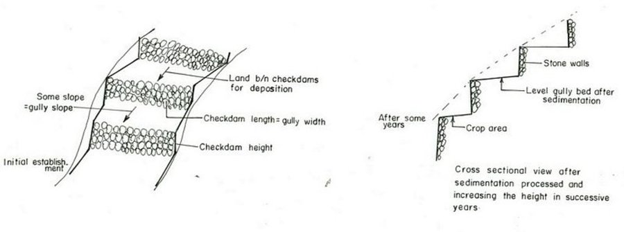
The technology is known by the farmers for more than a century. Since the area is highly affected by gully erosion, this practice is widely used by farmers in the area and also widely practiced. Its construction starts from the bottom of the gully and proceeds upslope with different dimensions. The height depends on the depth of the gully and it is increased from year to year. On the average the width is 1m and hieght is 1.80m. The technology is used to develop big gullies and treatment of small gully like depressions, attain slope change to enhance land suitability to crop production and to conserve soil and water. The construction of the stone checkdam starts with small heights and some height is added every year until the intended height is reached. The increase in height could be done during maintenance also. The major objective being to stop gully growth, trap sediment and retain water running down the gully. In the course of increasing the height, the area for sediment deposition gets wider. The technology is suitable to areas with low rainfalls of rugged topography having a network of gullies.

Location

Location: Koshem Watershed, Amhara Regional State, Ethiopia

No. of Technology sites analysed:

Geo-reference of selected sites
  • 38.0, 11.0

Spread of the Technology: evenly spread over an area (approx. 10-100 km2)

In a permanently protected area?:

Date of implementation: more than 50 years ago (traditional)

Type of introduction

Classification of the Technology

Main purpose
  • improve production
  • reduce, prevent, restore land degradation
  • conserve ecosystem
  • protect a watershed/ downstream areas – in combination with other Technologies
  • preserve/ improve biodiversity
  • reduce risk of disasters
  • adapt to climate change/ extremes and its impacts
  • mitigate climate change and its impacts
  • create beneficial economic impact
  • create beneficial social impact
Land use

  • Cropland
    • Annual cropping: cereals - maize, cereals - sorghum, legumes and pulses - beans, legumes and pulses - other, oilseed crops - sunflower, rapeseed, other, haricot bean, teff
    • Perennial (non-woody) cropping
    • Tree and shrub cropping: citrus, coffee, open grown, fruits, other, mango, mangosteen, guava, papaya, acacia, eucalyptus, khata edulis, ageava sisal, banana, lemon
    Number of growing seasons per year: 2
    Is intercropping practiced? Ja
  • Grazing land
  • Forest/ woodlands
    • (Semi-)natural forests/ woodlands. Management: Clear felling
    Products and services: Timber, Fuelwood, Grazing/ browsing
Water supply
  • rainfed
  • mixed rainfed-irrigated
  • full irrigation

Purpose related to land degradation
  • prevent land degradation
  • reduce land degradation
  • restore/ rehabilitate severely degraded land
  • adapt to land degradation
  • not applicable
Degradation addressed
  • soil erosion by water - Wt: loss of topsoil/ surface erosion, Wg: gully erosion/ gullying
  • chemical soil deterioration - Cn: fertility decline and reduced organic matter content (not caused by erosion)
SLM group
  • surface water management (spring, river, lakes, sea)
SLM measures
  • agronomic measures - A1: Vegetation/ soil cover, A2: Organic matter/ soil fertility, A3: Soil surface treatment, A6: Residue management, A7: Others
  • vegetative measures -
  • structural measures - S6: Walls, barriers, palisades, fences

Technical drawing

Technical specifications
Amhara

Technical knowledge required for field staff / advisors: high

Technical knowledge required for land users: moderate

Main technical functions: increase / maintain water stored in soil, sediment retention / trapping, sediment harvesting

Secondary technical functions: reduction of slope angle, reduction of slope length, increase of infiltration

Mixed cropping / intercropping
Material/ species: sorghum/maize +haricot beans
Quantity/ density: 70,000 sor
Remarks: broadcast

Agronomic measure: mixed cropping / intercropping
Material/ species: teff + sunflower
Quantity/ density: -
Remarks: broadcast

Manure / compost / residues
Material/ species: Animal dung, fuelwood ash, leaves, soil
Quantity/ density: 0.6 ton/ha

Contour tillage
Remarks: along contour

Agronomic measure: Sediment trapped by checkdam
Remarks: along the contour

Agronomic measure: Seedbed preparation by hoe

Aligned: -contour
Vegetative material: T : trees / shrubs
Number of plants per (ha): 1500
Vertical interval between rows / strips / blocks (m): 1-1.8m
Spacing between rows / strips / blocks (m): 8-10m
Vertical interval within rows / strips / blocks (m): 1-2m
Width within rows / strips / blocks (m): 1x1

Vegetative measure: aligned: contour
Vegetative material: G : grass
Number of plants per (ha): -
Vertical interval between rows / strips / blocks (m): 1-1.8m
Spacing between rows / strips / blocks (m): 8-10m
Vertical interval within rows / strips / blocks (m): -
Width within rows / strips / blocks (m): -

Vegetative measure: aligned: contour
Vegetative material: G : grass
Number of plants per (ha): 2000
Vertical interval between rows / strips / blocks (m): 1-1.8m
Spacing between rows / strips / blocks (m): 8-10m
Vertical interval within rows / strips / blocks (m): -
Width within rows / strips / blocks (m): -

Vegetative measure: Vegetative material: G : grass

Vegetative measure: Vegetative material: G : grass

Trees/ shrubs species: acacia, eucalyptus, khata edulis, ageava sisal

Fruit trees / shrubs species: coffee, papaya, guava, banana, lemon, manago, orange

Grass species: elephant grass, local grass

Slope (which determines the spacing indicated above): 12.00%

If the original slope has changed as a result of the Technology, the slope today is (see figure below): 3.00%

Gradient along the rows / strips: 0.00%

Structural measure: Checkdam
Vertical interval between structures (m): 1
Spacing between structures (m): 8m
Depth of ditches/pits/dams (m): 0.3m
Width of ditches/pits/dams (m): 1m
Length of ditches/pits/dams (m): 5m
Height of bunds/banks/others (m): 0.5-1m
Width of bunds/banks/others (m): 1m
Length of bunds/banks/others (m): 5.m

Construction material (earth): Soil is embnked upslope of the stone wall as reinforcement

Construction material (stone): Stone is used to construct the embankment/wall/and is supported by soil in the upslope side to reinf

Construction material (wood): Wood used as support at the downslope side

Slope (which determines the spacing indicated above): 12%

If the original slope has changed as a result of the Technology, the slope today is: 3%

Lateral gradient along the structure: 0%

For water harvesting: the ratio between the area where the harvested water is applied and the total area from which water is collected is: 1:3

Vegetation is used for stabilisation of structures.

Change of land use type: gully converted to cropland

Other type of management: fencing and guarding - protect animals from interering to plantations

Establishment and maintenance: activities, inputs and costs

Calculation of inputs and costs
  • Costs are calculated:
  • Currency used for cost calculation: Birr
  • Exchange rate (to USD): 1 USD = 8.6 Birr
  • Average wage cost of hired labour per day: 0.70
Most important factors affecting the costs
labour, slope and depth of the gully, width of the gully, availability of construction material, soil depth. The establishment cost considerts the cost incurred over 15 years.
Establishment activities
  1. Seedling production (Timing/ frequency: March to June)
  2. Planting (Timing/ frequency: June to July)
  3. Excavation (Timing/ frequency: dry season)
  4. Stone collection (Timing/ frequency: dry season)
  5. Construction (Timing/ frequency: dry season)
  6. Fencing (Timing/ frequency: after plantation)
Establishment inputs and costs
Specify input Unit Quantity Costs per Unit (Birr) Total costs per input (Birr) % of costs borne by land users
Labour
Labour ha 1.0 4625.0 4625.0 90.0
Equipment
Tools ha 1.0 120.0 120.0 95.0
Construction material
Stone ha 1.0 100.0
Total costs for establishment of the Technology 4'745.0
Total costs for establishment of the Technology in USD 551.74
Maintenance activities
  1. clean crop residue (Timing/ frequency: Early January /)
  2. primary digging (Timing/ frequency: Feb-March /)
  3. harrowing (Timing/ frequency: March /)
  4. manure application (Timing/ frequency: March /)
  5. planting (Timing/ frequency: April /)
  6. weeding and cultivation (Timing/ frequency: Late June-August /)
  7. harvest (Timing/ frequency: November-December /)
  8. replanting (Timing/ frequency: during rains /once a year)
  9. pruning and thining (Timing/ frequency: dry season /once a year)
  10. Stone collection (Timing/ frequency: dry season/once a year)
  11. Placing the stones where maintenance is required (Timing/ frequency: dry season/once a year)
  12. repairing breaks in fences (Timing/ frequency: before replanting / annual)
Maintenance inputs and costs
Specify input Unit Quantity Costs per Unit (Birr) Total costs per input (Birr) % of costs borne by land users
Labour
Labour ha 1.0 624.0 624.0 100.0
Equipment
Tools ha 1.0 30.0 30.0 100.0
Construction material
Stone ha 1.0 100.0
Total costs for maintenance of the Technology 654.0
Total costs for maintenance of the Technology in USD 76.05

Natural environment

Average annual rainfall
  • < 250 mm
  • 251-500 mm
  • 501-750 mm
  • 751-1,000 mm
  • 1,001-1,500 mm
  • 1,501-2,000 mm
  • 2,001-3,000 mm
  • 3,001-4,000 mm
  • > 4,000 mm
Agro-climatic zone
  • humid
  • sub-humid
  • semi-arid
  • arid
Specifications on climate
Specification 500-750 mm (600mm)
Specification 750-1000 mm (900mm)

Semi-arid: In the SWC area the semiarid part is about 70%
Sub-humid: Comprises about 30%
Slope
  • flat (0-2%)
  • gentle (3-5%)
  • moderate (6-10%)
  • rolling (11-15%)
  • hilly (16-30%)
  • steep (31-60%)
  • very steep (>60%)
Landforms
  • plateau/plains
  • ridges
  • mountain slopes
  • hill slopes
  • footslopes
  • valley floors
Altitude
  • 0-100 m a.s.l.
  • 101-500 m a.s.l.
  • 501-1,000 m a.s.l.
  • 1,001-1,500 m a.s.l.
  • 1,501-2,000 m a.s.l.
  • 2,001-2,500 m a.s.l.
  • 2,501-3,000 m a.s.l.
  • 3,001-4,000 m a.s.l.
  • > 4,000 m a.s.l.
Technology is applied in
  • convex situations
  • concave situations
  • not relevant
Soil depth
  • very shallow (0-20 cm)
  • shallow (21-50 cm)
  • moderately deep (51-80 cm)
  • deep (81-120 cm)
  • very deep (> 120 cm)
Soil texture (topsoil)
  • coarse/ light (sandy)
  • medium (loamy, silty)
  • fine/ heavy (clay)
Soil texture (> 20 cm below surface)
  • coarse/ light (sandy)
  • medium (loamy, silty)
  • fine/ heavy (clay)
Topsoil organic matter content
  • high (>3%)
  • medium (1-3%)
  • low (<1%)
Groundwater table
  • on surface
  • < 5 m
  • 5-50 m
  • > 50 m
Availability of surface water
  • excess
  • good
  • medium
  • poor/ none
Water quality (untreated)
  • good drinking water
  • poor drinking water (treatment required)
  • for agricultural use only (irrigation)
  • unusable
Is salinity a problem?
  • Ja
  • Nee

Occurrence of flooding
  • Ja
  • Nee
Species diversity
  • high
  • medium
  • low
Habitat diversity
  • high
  • medium
  • low

Characteristics of land users applying the Technology

Market orientation
  • subsistence (self-supply)
  • mixed (subsistence/ commercial)
  • commercial/ market
Off-farm income
  • less than 10% of all income
  • 10-50% of all income
  • > 50% of all income
Relative level of wealth
  • very poor
  • poor
  • average
  • rich
  • very rich
Level of mechanization
  • manual work
  • animal traction
  • mechanized/ motorized
Sedentary or nomadic
  • Sedentary
  • Semi-nomadic
  • Nomadic
Individuals or groups
  • individual/ household
  • groups/ community
  • cooperative
  • employee (company, government)
Gender
  • women
  • men
Age
  • children
  • youth
  • middle-aged
  • elderly
Area used per household
  • < 0.5 ha
  • 0.5-1 ha
  • 1-2 ha
  • 2-5 ha
  • 5-15 ha
  • 15-50 ha
  • 50-100 ha
  • 100-500 ha
  • 500-1,000 ha
  • 1,000-10,000 ha
  • > 10,000 ha
Scale
  • small-scale
  • medium-scale
  • large-scale
Land ownership
  • state
  • company
  • communal/ village
  • group
  • individual, not titled
  • individual, titled
Land use rights
  • open access (unorganized)
  • communal (organized)
  • leased
  • individual
Water use rights
  • open access (unorganized)
  • communal (organized)
  • leased
  • individual
Access to services and infrastructure

Impacts

Socio-economic impacts
Crop production
decreased
x
increased


The cost benefit anlysis for sorghum shows negative profit but for other crops such as combination of coffe, papaya, chat the profit is high

fodder production
decreased
x
increased

fodder quality
decreased
x
increased

farm income
decreased
x
increased


for cropping patterns which consider field crops + cash crops is high

Socio-cultural impacts
SLM/ land degradation knowledge
reduced
x
improved

Ecological impacts
surface runoff
increased
x
decreased

Quantity before SLM: 70
Quantity after SLM: 5

soil moisture
decreased
x
increased


soil depth increased by depostion infiltration enhanced

soil cover
reduced
x
improved


plantations

soil loss
increased
x
decreased

Quantity before SLM: 10
Quantity after SLM: 0
checdams decrease gully slope

Soil fertility
decreased
x
increased


Fertile top soil erdoed upslope is trapped in the gully

Biodiversity
decreased
x
increased


combined application of useful plants and crop

Off-site impacts
reliable and stable stream flows in dry season (incl. low flows)
reduced
x
increased


high percolation rate of rain water

downstream flooding (undesired)
increased
x
reduced


runoff is trapped by supportive technologies undertaken in the upper catchment and runoof velocity retarded by checkdams

downstream siltation
increased
x
decreased


sediment trapped in the gullies

Cost-benefit analysis

Benefits compared with establishment costs
Short-term returns
very negative
x
very positive

Long-term returns
very negative
x
very positive

Benefits compared with maintenance costs
Short-term returns
very negative
x
very positive

Long-term returns
very negative
x
very positive

Climate change

-

Adoption and adaptation

Percentage of land users in the area who have adopted the Technology
  • single cases/ experimental
  • 1-10%
  • 11-50%
  • > 50%
Of all those who have adopted the Technology, how many have done so without receiving material incentives?
  • 0-10%
  • 11-50%
  • 51-90%
  • 91-100%
Number of households and/ or area covered
25000
Has the Technology been modified recently to adapt to changing conditions?
  • Ja
  • Nee
To which changing conditions?
  • climatic change/ extremes
  • changing markets
  • labour availability (e.g. due to migration)

Conclusions and lessons learnt

Strengths: land user's view
  • Land reclaimed

    How can they be sustained / enhanced? fertility of soils increased by accumulated top soil from other area.
  • retain moisture

    How can they be sustained / enhanced? water stored in the soil.
Strengths: compiler’s or other key resource person’s view
  • Reduce runoff speed

    How can they be sustained / enhanced? exercise frequent maintenance and stablize the structure with vegetative measures
  • Reduce soil loss

    How can they be sustained / enhanced? soil is trapped by the checkdam
  • Moisture retention

    How can they be sustained / enhanced? the soil trapped provides more space for water to be stored.
  • reduce slope length

    How can they be sustained / enhanced? by raising the gully bed.
Weaknesses/ disadvantages/ risks: land user's viewhow to overcome
Weaknesses/ disadvantages/ risks: compiler’s or other key resource person’s viewhow to overcome

References

Compiler
  • Unknown User
Editors
Reviewer
  • Fabian Ottiger
  • Alexandra Gavilano
Date of documentation: Mei 29, 2011
Last update: Sept. 9, 2019
Resource persons
Full description in the WOCAT database
Linked SLM data
Documentation was faciliated by
Institution Project
Key references
  • Monthly, quarterly and annual achievement reports of the DWARDO:
  • Work norm of MERET:
  • Ethiopian Highlands Reclamation stdy:
  • Soil and water conservation , Morgan 1986:
This work is licensed under Creative Commons Attribution-NonCommercial-ShareaAlike 4.0 International