Marshy land transformed into productive land [Bangladesh]
- Creation:
- Update:
- Compiler: Rahatul Islam
- Editor: –
- Reviewers: Alexandra Gavilano, Ursula Gaemperli, Donia Mühlematter
technologies_1769 - Bangladesh
View sections
Expand all Collapse all1. General information
1.2 Contact details of resource persons and institutions involved in the assessment and documentation of the Technology
1.3 Conditions regarding the use of data documented through WOCAT
The compiler and key resource person(s) accept the conditions regarding the use of data documented through WOCAT:
Ja
1.4 Declaration on sustainability of the described Technology
Is the Technology described here problematic with regard to land degradation, so that it cannot be declared a sustainable land management technology?
Nee
2. Description of the SLM Technology
2.1 Short description of the Technology
Definition of the Technology:
Marshy land is transformed into a ridge and ditch area, where the ridges are wide enough for the nursery of diverse plants and seedlings and where after 6-8 years the yearly management practices the land got strong enough for various agricultural practices (i.e. guava, hog plum, plums and timber wood plantation).
2.2 Detailed description of the Technology
Description:
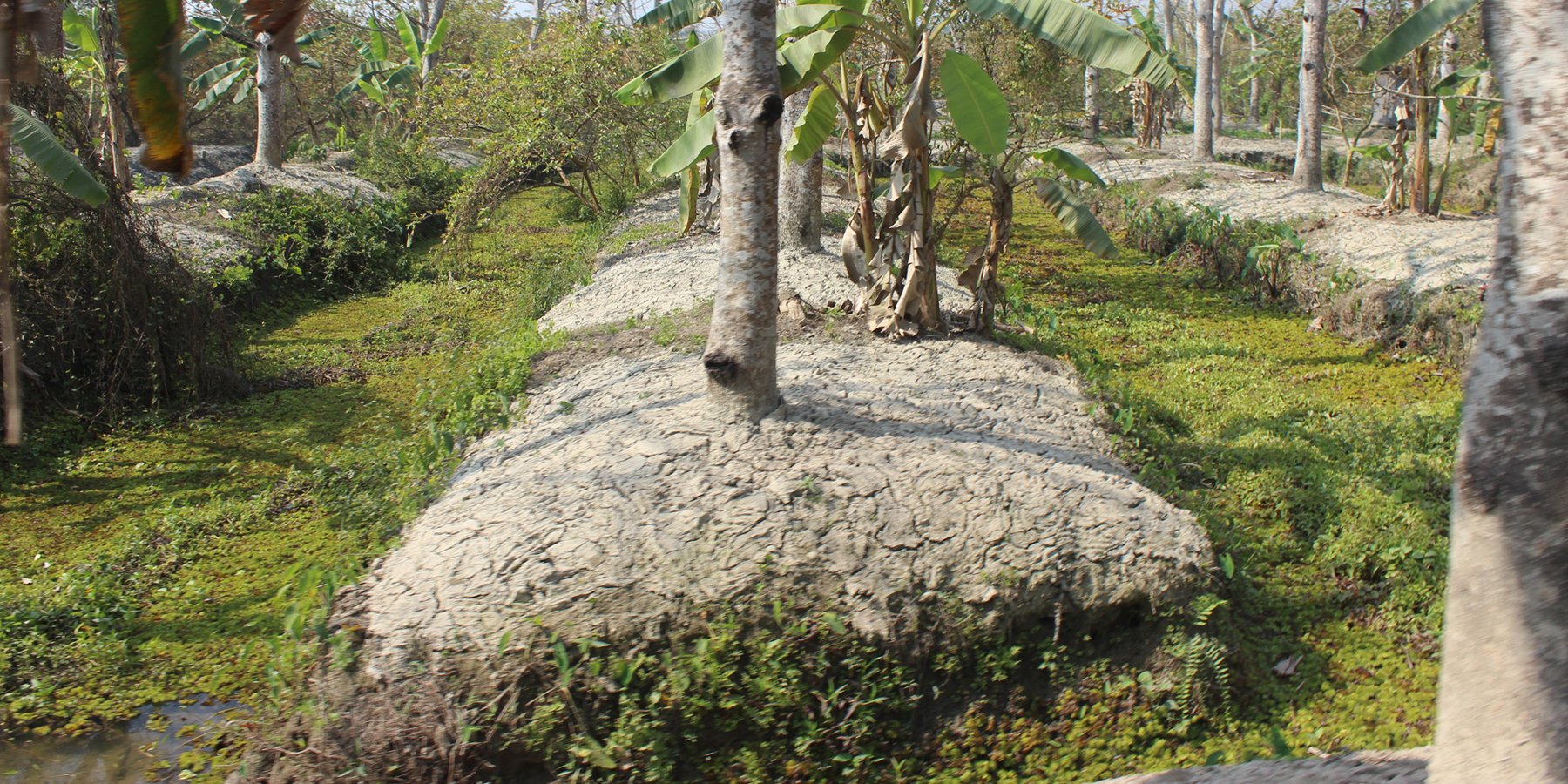
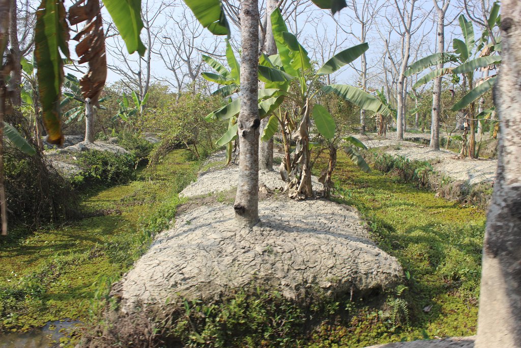
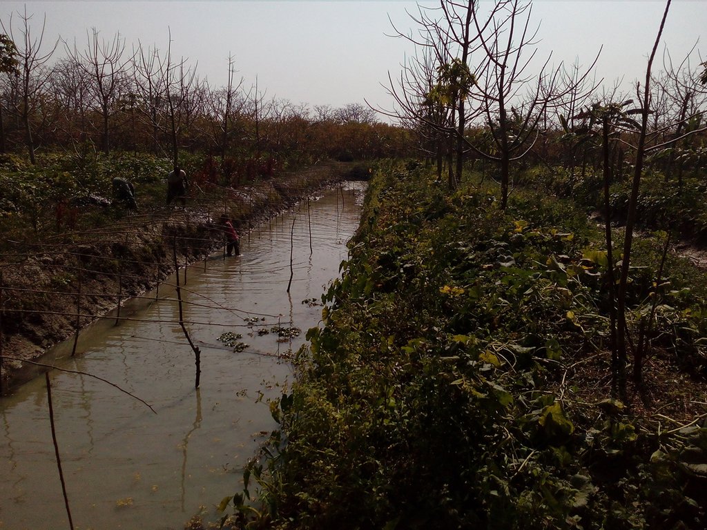
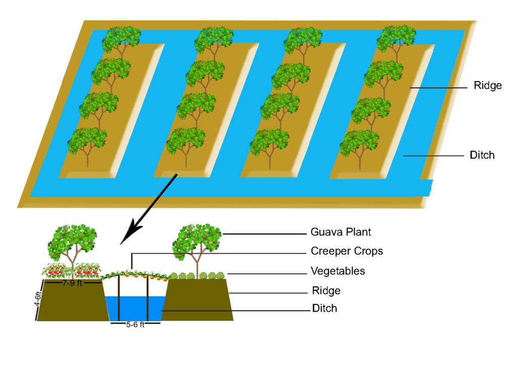
The technology of marshy land convert into ridge and ditch was taken by a community of southern of Bangladesh in order to make that area productive. Long year ago a continuous marshy land covered most of the area of southern Bangladesh like Pirjpur, Jhalokath. This area was flooded more than 9 month and remain perennial wet, that were totally unproductive. So, that technology not only increases agricultural production or economical benefits but also creates a green belt by developing agro-forest. The technology consists of ridge and ditch area. Ridges are elevated beds - land which is 4-6 feet high from surface and 7-9 feet wide. Length of each bed is variable according to size of the land. And ditches are canals - areas that are 5-6 feet wide and deeper than the normal surface area.
At initial stage elevated areas are not strong enough to start cultivating trees like guava, hug plum or other fruit plants. So they use it for nursery of diversified plants, fruit trees such as Banana and Papaya, vegetables, preparation of seedling sapling or as seedbed (rice). Management practices are running every year to develop the ridges and make them strong. Land users are putting soil/muck from the ditches on the ridges to make them higher and to give better protection from flooding water, to increase the fertility, to conserve moisture and reserve organic matter. Though eroded soil and other plant residues are accumulated in the ditches so ultimately they return over the ridge surface. Land become suitable after 4-5 year for planting various trees like guava hog plum, plums, lemons, Areca nuts and various timber producing tress like Teak (Tectona grandis), Mahogany (Swietenia mahagoni). Approximately 7 – 8 year after fruit trees are become appropriate and the physical and biological conditions of the sites have improved. Then land user start to cultivate various vegetables and other agricultural practices. Furthermore, sometime users set up a platform for creeper crops on the canal which works as support for Pumpkins and gourds. Trees and vegetables are irrigated from ditch/canal where water is reserve over the year, even in dry season if necessary. As a result of growing biomass, land degradation from the site has reduced and the fertility of the soil has increased. When fruit trees have reached its harvesting stage, the land users collect fruits for sale with expected income of about 1000USD. Vegetable also provide more than 500USD benefit from each site every year. Approximately 25 years after Mahogany, Teak, and other timber producing trees are getting mature and reach their harvesting stage. Land user cut the trees for selling with expected income of about 10000 USD from each site and size of approximately one hectare.
The technology is working well and is easily manageable by the land users. Nowadays not only farmers but also a large portion of population are interacting with that technology and their lifestyle have changed. Many people are also working to manufacture initial nursery products like seedling bag, earthen pot, creeping materials like bamboo, string, yarn, net, seedling and other material for preparing plant nursery, fruit garden, mixed agro-forest etc. Other people work to transport product from the area to the consumers and some people work to manufacture vehicles like boats, local vans etc. Also locale communities developed the largest floating market of Bangladesh.
The farmers are applying the technology without any extra financial support. According to the land users, they estimate about 200 – 300 family which have applied the technology. Approximately 350 person-day/ha were employed for construction and 50 person – day/ha sufficient for yearly maintenance work. 1600 USD was spending on the construction and most of the cost covered by owner. Farmers have faced some drawback such as undeveloped communication infrastructure and insufficiently developed market places. On the other hand, if they get support from government and related authority, this technology even become more beneficial for them.
2.3 Photos of the Technology
2.5 Country/ region/ locations where the Technology has been applied and which are covered by this assessment
Country:
Bangladesh
Region/ State/ Province:
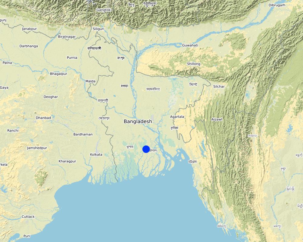
Atghar Kuriana Union, Swarupkati, Pirojpur
Further specification of location:
Barisal
Specify the spread of the Technology:
- evenly spread over an area
If precise area is not known, indicate approximate area covered:
- 10-100 km2
Comments:
sites are increasing day by day and enter into deep swampy land.
The technology expanding with time.
Map
×2.6 Date of implementation
If precise year is not known, indicate approximate date:
- 10-50 years ago
2.7 Introduction of the Technology
Specify how the Technology was introduced:
- through land users' innovation
3. Classification of the SLM Technology
3.1 Main purpose(s) of the Technology
- improve production
- create beneficial economic impact
- create beneficial social impact
3.2 Current land use type(s) where the Technology is applied
Land use mixed within the same land unit:
Ja
Specify mixed land use (crops/ grazing/ trees):
- Agroforestry

Cropland
- Annual cropping
- Perennial (non-woody) cropping
- Tree and shrub cropping
Annual cropping - Specify crops:
- vegetables - other
- rice
Perennial (non-woody) cropping - Specify crops:
- banana/plantain/abaca
Tree and shrub cropping - Specify crops:
- mango, mangosteen, guava
- papaya
Number of growing seasons per year:
- 1
Specify:
perennial
Is intercropping practiced?
Ja

Forest/ woodlands
Type of tree:
- Tectona grandis
- Swietenia mahagoni
Products and services:
- Timber
- Fruits and nuts
Comments:
Main crops are guava and hog plum. vegetables are harvested within five to six month. Bananas and papaya stay for several years. woody trees are harvest after they get mature.
3.4 Water supply
Water supply for the land on which the Technology is applied:
- rainfed
3.5 SLM group to which the Technology belongs
- agroforestry
- wetland protection/ management
- convert marshy land into productive ridge and ditch
3.6 SLM measures comprising the Technology

agronomic measures
- A1: Vegetation/ soil cover

vegetative measures
- V1: Tree and shrub cover

structural measures
- S2: Bunds, banks
3.7 Main types of land degradation addressed by the Technology

physical soil deterioration
- Pw: waterlogging

water degradation
- Hs: change in quantity of surface water
Comments:
Land was lower and flooded more than 9 month and remain perennial wet. So the technology helps to overcome waterlogged condition and remain surface water over the year even in dry season at ditch area.
3.8 Prevention, reduction, or restoration of land degradation
Specify the goal of the Technology with regard to land degradation:
- restore/ rehabilitate severely degraded land
4. Technical specifications, implementation activities, inputs, and costs
4.1 Technical drawing of the Technology
Technical specifications (related to technical drawing):
Method of marshy land transform into productive land bases on ridges and ditches. ridges are 7-9 feet wide and 4-6 feet high. Height is variable because yearly management practices increase the height of the ridges. Ditches are connected with each other from the edge/end of the each ridge. This types of connection support water movement and the moving of the boats for crop management and crop harvesting.
Author:
Selim Hossain
Date:
03/02/2017
4.2 General information regarding the calculation of inputs and costs
Specify how costs and inputs were calculated:
- per Technology area
Indicate size and area unit:
1 hectare
Specify currency used for cost calculations:
- USD
Indicate average wage cost of hired labour per day:
5 USD
4.3 Establishment activities
| Activity | Timing (season) | |
|---|---|---|
| 1. | Develop ridge and ditch | 7-15 days |
| 2. | vegetative cover with vegetables, seedling, sapling | 2-3 months |
| 3. | fruit trees, timber producing trees | 3-25 years |
Comments:
Mainly the structural measure are important. But other measures are also important to make the technology stable. At initial stage without vegetative measure, soil will not become stable enough to take further steps of plantation.
4.4 Costs and inputs needed for establishment
| Specify input | Unit | Quantity | Costs per Unit | Total costs per input | % of costs borne by land users | |
|---|---|---|---|---|---|---|
| Labour | skilled labor | person-days | 300.0 | 5.0 | 1500.0 | 100.0 |
| Plant material | seedling (fruit trees) | piece | 500.0 | 0.1 | 50.0 | 100.0 |
| Plant material | seedling (timber producing trees) | piece | 300.0 | 0.1 | 30.0 | 100.0 |
| Other | seedling bag | 1000.0 | 0.01 | 10.0 | 100.0 | |
| Other | earthen pot | 1000.0 | 0.01 | 10.0 | 100.0 | |
| Total costs for establishment of the Technology | 1600.0 | |||||
| Total costs for establishment of the Technology in USD | 1600.0 | |||||
If you are unable to break down the costs in the table above, give an estimation of the total costs of establishing the Technology:
3.0
4.5 Maintenance/ recurrent activities
| Activity | Timing/ frequency | |
|---|---|---|
| 1. | management practice to make ridges and ditches uniform and productive | 3-7days |
| 2. | seasonal vegetable | 2-3 month |
4.6 Costs and inputs needed for maintenance/ recurrent activities (per year)
| Specify input | Unit | Quantity | Costs per Unit | Total costs per input | % of costs borne by land users | |
|---|---|---|---|---|---|---|
| Labour | skilled labor | person-days | 50.0 | 5.0 | 250.0 | 100.0 |
| Plant material | seedling vegetable ( e.g gourd) | pieces | 250.0 | 0.05 | 12.5 | 100.0 |
| Construction material | bamboo | pieces | 50.0 | 1.0 | 50.0 | 100.0 |
| Construction material | string, ropes | piece | 1.0 | 5.0 | 5.0 | 100.0 |
| Total costs for maintenance of the Technology | 317.5 | |||||
| Total costs for maintenance of the Technology in USD | 317.5 | |||||
4.7 Most important factors affecting the costs
Describe the most determinate factors affecting the costs:
Basket, spade and other equipment which are needs to develop the site is not carried by land user, these are collecting by laborers. transportation cost also carried by local traders. farmers are represent their product in local market (floating guava market) and then local traders are buy it and transport it to city or capital
5. Natural and human environment
5.1 Climate
Annual rainfall
- < 250 mm
- 251-500 mm
- 501-750 mm
- 751-1,000 mm
- 1,001-1,500 mm
- 1,501-2,000 mm
- 2,001-3,000 mm
- 3,001-4,000 mm
- > 4,000 mm
Specifications/ comments on rainfall:
Length of rainy season 5 month that causes water level becoming close to the bed.
Agro-climatic zone
- sub-humid
5.2 Topography
Slopes on average:
- flat (0-2%)
- gentle (3-5%)
- moderate (6-10%)
- rolling (11-15%)
- hilly (16-30%)
- steep (31-60%)
- very steep (>60%)
Landforms:
- plateau/plains
- ridges
- mountain slopes
- hill slopes
- footslopes
- valley floors
Altitudinal zone:
- 0-100 m a.s.l.
- 101-500 m a.s.l.
- 501-1,000 m a.s.l.
- 1,001-1,500 m a.s.l.
- 1,501-2,000 m a.s.l.
- 2,001-2,500 m a.s.l.
- 2,501-3,000 m a.s.l.
- 3,001-4,000 m a.s.l.
- > 4,000 m a.s.l.
Indicate if the Technology is specifically applied in:
- not relevant
5.3 Soils
Soil depth on average:
- very shallow (0-20 cm)
- shallow (21-50 cm)
- moderately deep (51-80 cm)
- deep (81-120 cm)
- very deep (> 120 cm)
Soil texture (topsoil):
- medium (loamy, silty)
Soil texture (> 20 cm below surface):
- medium (loamy, silty)
Topsoil organic matter:
- high (>3%)
5.4 Water availability and quality
Ground water table:
< 5 m
Availability of surface water:
good
Water quality (untreated):
for agricultural use only (irrigation)
Is water salinity a problem?
Nee
Is flooding of the area occurring?
Ja
Regularity:
episodically
Comments and further specifications on water quality and quantity:
flooding normally occur in rainy season but it is not destructive for the technology
5.5 Biodiversity
Species diversity:
- medium
Habitat diversity:
- medium
Comments and further specifications on biodiversity:
This green belt workes as shelter for birds.
5.6 Characteristics of land users applying the Technology
Sedentary or nomadic:
- Sedentary
Market orientation of production system:
- mixed (subsistence/ commercial)
Off-farm income:
- 10-50% of all income
Relative level of wealth:
- rich
Individuals or groups:
- individual/ household
Level of mechanization:
- manual work
Gender:
- women
- men
Age of land users:
- middle-aged
5.7 Average area of land used by land users applying the Technology
- < 0.5 ha
- 0.5-1 ha
- 1-2 ha
- 2-5 ha
- 5-15 ha
- 15-50 ha
- 50-100 ha
- 100-500 ha
- 500-1,000 ha
- 1,000-10,000 ha
- > 10,000 ha
Is this considered small-, medium- or large-scale (referring to local context)?
- medium-scale
Comments:
Size depends on user capability. Sometime users like to make smaller sites which are easy to maintain. Larger sites reduce waste of land and give extra space to cultivation.
5.8 Land ownership, land use rights, and water use rights
Land ownership:
- individual, titled
Land use rights:
- individual
Water use rights:
- open access (unorganized)
5.9 Access to services and infrastructure
health:
- poor
- moderate
- good
education:
- poor
- moderate
- good
technical assistance:
- poor
- moderate
- good
employment (e.g. off-farm):
- poor
- moderate
- good
markets:
- poor
- moderate
- good
energy:
- poor
- moderate
- good
roads and transport:
- poor
- moderate
- good
drinking water and sanitation:
- poor
- moderate
- good
financial services:
- poor
- moderate
- good
6. Impacts and concluding statements
6.1 On-site impacts the Technology has shown
Socio-economic impacts
Production
crop production
Comments/ specify:
bare land become productive
crop quality
Comments/ specify:
organic materials are mainly used
fodder production
Comments/ specify:
vegetable and fruit resides can use as animal food
fodder quality
wood production
Comments/ specify:
timber trees not only fill local demand but also supply in many area of Bangladesh
forest/ woodland quality
risk of production failure
Comments/ specify:
Crop failure by flooding is protected
product diversity
Comments/ specify:
Here produce timber, fruit, vegetable, seedling sapling etc
production area
Comments/ specify:
production area remarkably increase
land management
Comments/ specify:
Very easy and local farmers manage it easily.
Water availability and quality
irrigation water availability
Comments/ specify:
Water is available even in dry season
irrigation water quality
demand for irrigation water
Comments/ specify:
ditch contain enough water in available condition for plant
Income and costs
expenses on agricultural inputs
farm income
diversity of income sources
Comments/ specify:
Peoples not only depend on agriculture.
economic disparities
Comments/ specify:
It reduces the economic disparities as it opens new working places.
workload
Socio-cultural impacts
food security/ self-sufficiency
Comments/ specify:
Net yearly production of food increases.
health situation
Comments/ specify:
People get proper nutrient from fruits and vegetable, which are totally chemical free
land use/ water rights
cultural opportunities
situation of socially and economically disadvantaged groups
Comments/ specify:
not only men but also women are work on site. normally land users family members are always help them every way
Ecological impacts
Water cycle/ runoff
water quantity
Comments/ specify:
Total amount of water is reduced.
water quality
Comments/ specify:
Good quality water found in all seasons.
excess water drainage
Comments/ specify:
Drainage condition of cultivated ridge area is very good
evaporation
Comments/ specify:
Vegetative cover reduces the total evaporation .
Soil
soil moisture
Comments/ specify:
Yearly management practice helps to increase the soil moisture.
soil cover
Comments/ specify:
Annual and perennial crops cover the area.
soil loss
nutrient cycling/ recharge
Comments/ specify:
Plant residue.
soil organic matter/ below ground C
Comments/ specify:
Release reserved carbon from muck.
Biodiversity: vegetation, animals
Vegetation cover
Comments/ specify:
A bare land convert into vegetative cover
biomass/ above ground C
plant diversity
Comments/ specify:
Variety among plants and crops is seem.
animal diversity
Comments/ specify:
The trees serve as nesting habitat
beneficial species
Climate and disaster risk reduction
flood impacts
Comments/ specify:
ridges are free from flood
drought impacts
Comments/ specify:
water reserved in ditch in dry season
emission of carbon and greenhouse gases
Comments/ specify:
large vegetation consume huge amount of carbon dioxide and greenhouse gases
wind velocity
micro-climate
6.2 Off-site impacts the Technology has shown
water availability
buffering/ filtering capacity
wind transported sediments
damage on neighbours' fields
damage on public/ private infrastructure
impact of greenhouse gases
6.4 Cost-benefit analysis
How do the benefits compare with the establishment costs (from land users’ perspective)?
Short-term returns:
slightly negative
Long-term returns:
very positive
How do the benefits compare with the maintenance/ recurrent costs (from land users' perspective)?
Short-term returns:
slightly positive
Long-term returns:
very positive
Comments:
To develop such kinds of structure requires a huge amount of investment which is not covered in a short time. But in the future it becomes highly beneficial. Yearly maintenance practices not only increase soil fertility, moisture and nutrient availability but land become higher from flooding water as well.
6.5 Adoption of the Technology
- 1-10%
Of all those who have adopted the Technology, how many did so spontaneously, i.e. without receiving any material incentives/ payments?
- 51-90%
6.6 Adaptation
Has the Technology been modified recently to adapt to changing conditions?
Nee
6.7 Strengths/ advantages/ opportunities of the Technology
| Strengths/ advantages/ opportunities in the land user’s view |
|---|
| The Technology increase the amount of productive land. |
| Peoples economic condition have changed to the better. This technology creates working place for many people. |
| The Technology increase availability of fresh products. e.g vegetable, fruits. |
| The development of largest floating market of Bangladesh is seen as very positive. |
| Strengths/ advantages/ opportunities in the compiler’s or other key resource person’s view |
|---|
| The Technology increase the greenhouse gas consumption. |
| Seedling and sapling are distributed in whole country and increase the vegetation cover. |
| It fulfills the demand of timber and it reduces the deforestation of natural forests. |
6.8 Weaknesses/ disadvantages/ risks of the Technology and ways of overcoming them
| Weaknesses/ disadvantages/ risks in the land user’s view | How can they be overcome? |
|---|---|
| The communication and transport infrastructure is not very well developped. | Reconstruction of the road. |
| Floating market are temporary and disapear after morning. | Make stable market places. |
| Farmer have no precise knowledge about crop, seeds and hybrid varieties. | Government and non-government organizations services is required. |
| Weaknesses/ disadvantages/ risks in the compiler’s or other key resource person’s view | How can they be overcome? |
|---|---|
| Water ecosystem is hampered | More research should be taken |
| Huge amount of reserved carbon get released. | Planting enough tree to consume that |
7. References and links
7.1 Methods/ sources of information
- field visits, field surveys
- interviews with land users
When were the data compiled (in the field)?
24/01/2017
Links and modules
Expand all Collapse allLinks
No links
Modules
No modules


