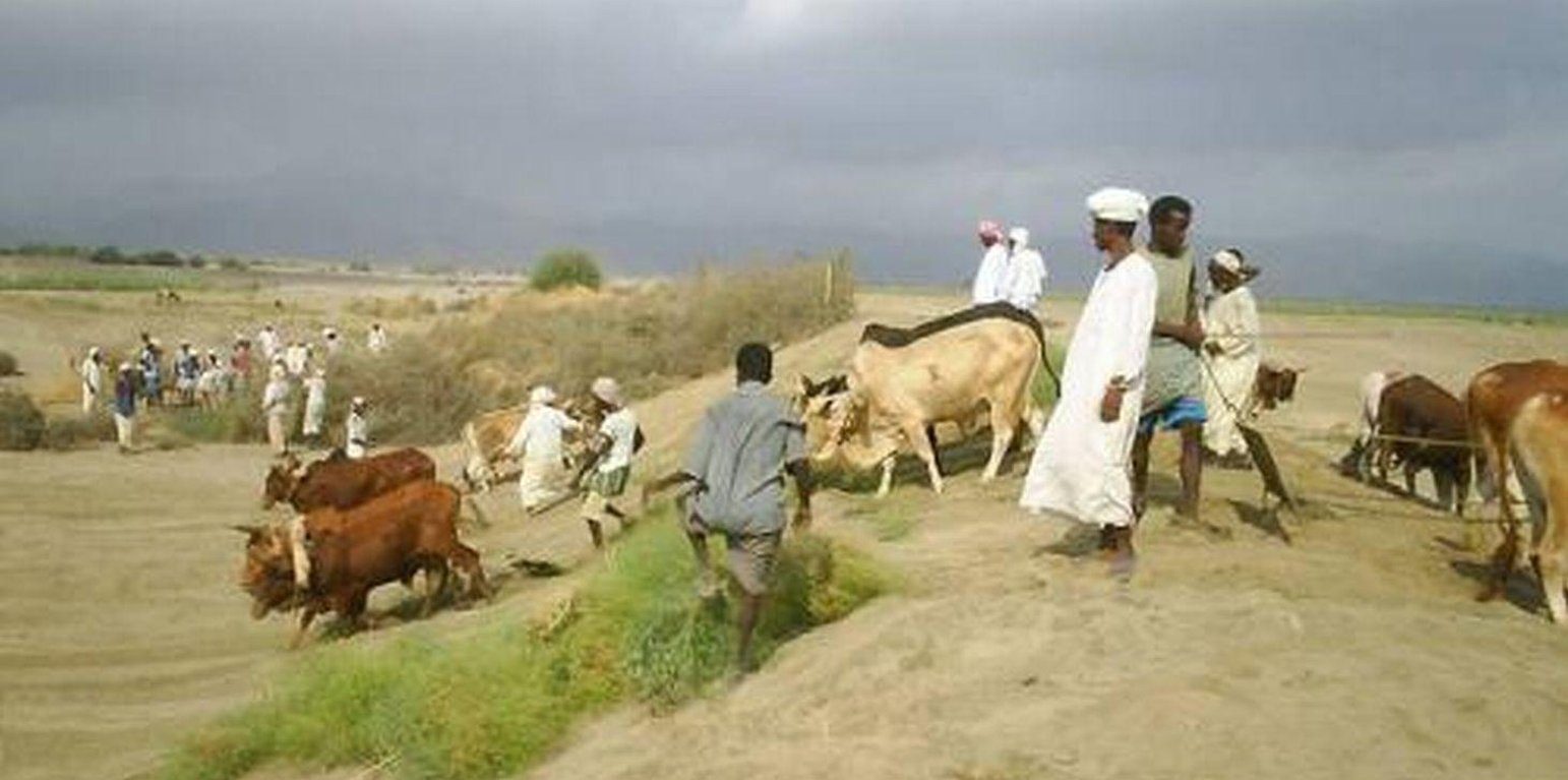
Social organisation and community action are prerequisites for spate irrigation systems: construction of an agim in a dry river bed (IFAD)

Spate Irrigation (Eritrea)

Description

Spate irrigation is a traditional water diversion and spreading technology.

Spate irrigation has a long history in Eritrea and still forms the livelihood base for rural communities in arid lowlands of the country.

Purpose of the Technology: It is a traditional water diversion and spreading technique under which seasonal floods of short duration – springing from the rainfall-rich highlands – are diverted from ephemeral rivers (wadis) to irrigate cascades of leveled and bunded fields in the coastal plains.

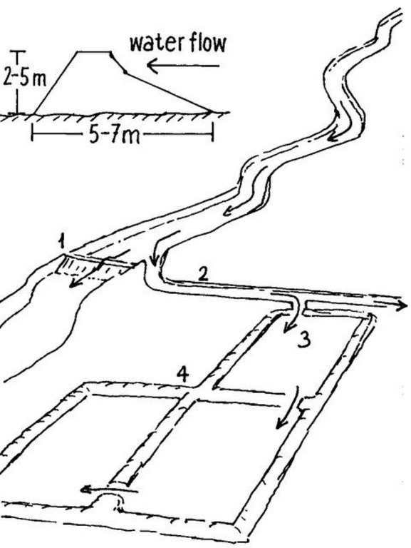
Establishment / maintenance activities and inputs: The diversion structures include the following elements: (1) the ‘agim’, a temporary 3-4 m high river diversion structure on the low-flow side of the wadi, made from brushwood, tree trunks, earth, stones and/or boulders, erected to divert a large part of the flow during a spate flow to adjacent agricultural fields; (2) a primary, and several secondary, distribution canals; unlined, bordered by earthen embankments; convey and spread the floodwater to the irrigable fields; (3) the fields, rectangular shaped, of about 1–2 ha, separated by earthen bunds. Floodwater is distributed from field to field: when a field is completely flooded (to a depth of about 0.5 m), water is conveyed to the immediate downstream field by breaching one of the bunds. This process continues until all the water is used up. Arable fields need to be flooded several times. The water soaks deep into the soil profile (up to 2.4 m) and provides moisture sufficient for two or even three harvests: crop growth is entirely dependent on the residual soil moisture. The main crop grown is sorghum; maize is the next most important. Sedimentation is as important as water management: With each flood, soil is built up by depositing rich sediment on the fields. Due to the force of the floods, the diversion structures are frequently damaged and/or washed away. Reconstruction and maintenance are labour-intensive and require collective community action.

Natural / human environment: Elaborate local regulations, organization and cooperation at the community level are prerequisites for successful management of spate irrigation systems.

Location

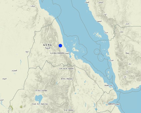
Location: Wadi Laba, Sheeb area, Eastern lowlands, Eritrea

No. of Technology sites analysed:

Geo-reference of selected sites
  • 39.0, 16.0

Spread of the Technology: evenly spread over an area (160.0 km²)

In a permanently protected area?:

Date of implementation: more than 50 years ago (traditional)

Type of introduction
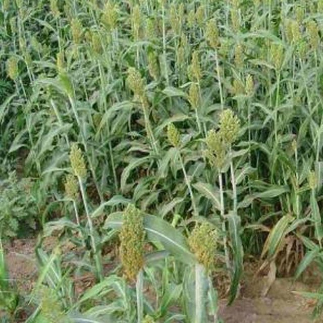
Fertile sediments and spate irrigation result in high sorghum yields (IFAD)

Classification of the Technology

Main purpose
  • improve production
  • reduce, prevent, restore land degradation
  • conserve ecosystem
  • protect a watershed/ downstream areas – in combination with other Technologies
  • preserve/ improve biodiversity
  • reduce risk of disasters
  • adapt to climate change/ extremes and its impacts
  • mitigate climate change and its impacts
  • create beneficial economic impact
  • create beneficial social impact
Land use

  • Cropland
    • Annual cropping: cereals - maize, cereals - sorghum

Water supply
  • rainfed
  • mixed rainfed-irrigated
  • full irrigation

Purpose related to land degradation
  • prevent land degradation
  • reduce land degradation
  • restore/ rehabilitate severely degraded land
  • adapt to land degradation
  • not applicable
Degradation addressed
SLM group
  • irrigation management (incl. water supply, drainage)
  • surface water management (spring, river, lakes, sea)
SLM measures
  • structural measures - S3: Graded ditches, channels, waterways

Technical drawing

Technical specifications
Cross section of an agim (top left); Components of a traditional spate irrigation system: (1) agim; (2) main distribution canal; (3) irrigated fields; (4) earthen embankments. Arrows indicate the water flow

Technical knowledge required for field staff / advisors: high

Technical knowledge required for land users: high

Main technical functions: control of concentrated runoff: drain / divert, increase of infiltration, water harvesting / increase water supply, water spreading

Diversion ditch/ drainage
Depth of ditches/pits/dams (m): 4.00

Construction material (earth): earth

Construction material (stone): stones

Construction material (wood): brushwood, tree trunks
Author: Mats Gurtner, Center for Development and Environment, University of Bern

Establishment and maintenance: activities, inputs and costs

Calculation of inputs and costs
  • Costs are calculated:
  • Currency used for cost calculation: n.a.
  • Exchange rate (to USD): 1 USD = n.a
  • Average wage cost of hired labour per day: n.a
Most important factors affecting the costs
Data on labour inputs for construction/maintenance of canals and field bunds are not included, therefore not included in the tables above. Costs for agim reconstruction are 40% of establishment. Total maintenance costs depend on the number of reconstructions during normal spate season (2-4 times). The yearly cost (establishment and maintenance) reaches US$ 60-156.
Establishment activities
  1. Construction of diversion structure (agim) (Timing/ frequency: before rainy season)
  2. Construction of main distribution canal (Timing/ frequency: before rainy season)
  3. Construction of secondary distribution canals (Timing/ frequency: before rainy season)
  4. Leveling of fields (Timing/ frequency: before rainy season)
  5. Establish embankments around fields and within fields (Timing/ frequency: before rainy season)
Establishment inputs and costs
Specify input Unit Quantity Costs per Unit (n.a.) Total costs per input (n.a.) % of costs borne by land users
Labour
Labour ha 1.0 24.0 24.0
Equipment
Animal traction ha 1.0 36.0 36.0
Total costs for establishment of the Technology 60.0
Total costs for establishment of the Technology in USD 60.0
Maintenance activities
  1. Reconstruction / repair of diversion structures (2-4 times / year; collective community action) (Timing/ frequency: 2-4 times / year)
  2. Desilting / repair of distribution canals (Timing/ frequency: annual)
  3. Raising of bund heights due to silting up of fields (Timing/ frequency: annual)
  4. Flood fields (community action, during highland rainy season: July-September). Most likely a field receives 3 irrigation turns, on a bi-weekly interval between any 2 turns (Timing/ frequency: rainy season (july-september))
  5. Soil tillage (15 cm deep; using oxen-drawn plough) to break capillary uplift of soil water and to create evaporation barrier (Timing/ frequency: end of flooding season)
Maintenance inputs and costs
Specify input Unit Quantity Costs per Unit (n.a.) Total costs per input (n.a.) % of costs borne by land users
Labour
Labour ha 1.0 24.0 24.0
Equipment
Animal traction ha 1.0 36.0 36.0
Total costs for maintenance of the Technology 60.0
Total costs for maintenance of the Technology in USD 60.0

Natural environment

Average annual rainfall
  • < 250 mm
  • 251-500 mm
  • 501-750 mm
  • 751-1,000 mm
  • 1,001-1,500 mm
  • 1,501-2,000 mm
  • 2,001-3,000 mm
  • 3,001-4,000 mm
  • > 4,000 mm
Agro-climatic zone
  • humid
  • sub-humid
  • semi-arid
  • arid
Specifications on climate
Thermal climate class: tropics
Slope
  • flat (0-2%)
  • gentle (3-5%)
  • moderate (6-10%)
  • rolling (11-15%)
  • hilly (16-30%)
  • steep (31-60%)
  • very steep (>60%)
Landforms
  • plateau/plains
  • ridges
  • mountain slopes
  • hill slopes
  • footslopes
  • valley floors
Altitude
  • 0-100 m a.s.l.
  • 101-500 m a.s.l.
  • 501-1,000 m a.s.l.
  • 1,001-1,500 m a.s.l.
  • 1,501-2,000 m a.s.l.
  • 2,001-2,500 m a.s.l.
  • 2,501-3,000 m a.s.l.
  • 3,001-4,000 m a.s.l.
  • > 4,000 m a.s.l.
Technology is applied in
  • convex situations
  • concave situations
  • not relevant
Soil depth
  • very shallow (0-20 cm)
  • shallow (21-50 cm)
  • moderately deep (51-80 cm)
  • deep (81-120 cm)
  • very deep (> 120 cm)
Soil texture (topsoil)
  • coarse/ light (sandy)
  • medium (loamy, silty)
  • fine/ heavy (clay)
Soil texture (> 20 cm below surface)
  • coarse/ light (sandy)
  • medium (loamy, silty)
  • fine/ heavy (clay)
Topsoil organic matter content
  • high (>3%)
  • medium (1-3%)
  • low (<1%)
Groundwater table
  • on surface
  • < 5 m
  • 5-50 m
  • > 50 m
Availability of surface water
  • excess
  • good
  • medium
  • poor/ none
Water quality (untreated)
  • good drinking water
  • poor drinking water (treatment required)
  • for agricultural use only (irrigation)
  • unusable
Water quality refers to:
Is salinity a problem?
  • Yes
  • No

Occurrence of flooding
  • Yes
  • No
Species diversity
  • high
  • medium
  • low
Habitat diversity
  • high
  • medium
  • low

Characteristics of land users applying the Technology

Market orientation
  • subsistence (self-supply)
  • mixed (subsistence/ commercial)
  • commercial/ market
Off-farm income
  • less than 10% of all income
  • 10-50% of all income
  • > 50% of all income
Relative level of wealth
  • very poor
  • poor
  • average
  • rich
  • very rich
Level of mechanization
  • manual work
  • animal traction
  • mechanized/ motorized
Sedentary or nomadic
  • Sedentary
  • Semi-nomadic
  • Nomadic
Individuals or groups
  • individual/ household
  • groups/ community
  • cooperative
  • employee (company, government)
Gender
  • women
  • men
Age
  • children
  • youth
  • middle-aged
  • elderly
Area used per household
  • < 0.5 ha
  • 0.5-1 ha
  • 1-2 ha
  • 2-5 ha
  • 5-15 ha
  • 15-50 ha
  • 50-100 ha
  • 100-500 ha
  • 500-1,000 ha
  • 1,000-10,000 ha
  • > 10,000 ha
Scale
  • small-scale
  • medium-scale
  • large-scale
Land ownership
  • state
  • company
  • communal/ village
  • group
  • individual, not titled
  • individual, titled
Land use rights
  • open access (unorganized)
  • communal (organized)
  • leased
  • individual
Water use rights
  • open access (unorganized)
  • communal (organized)
  • leased
  • individual
Access to services and infrastructure

Impacts

Socio-economic impacts
Crop production
decreased
increased

fodder production
decreased
increased


Residues are fed to livestock

production area (new land under cultivation/ use)
decreased
increased


Without irrigation, agricultural production is not possible

farm income
decreased
increased

Socio-cultural impacts
food security/ self-sufficiency
reduced
improved

community institutions
weakened
strengthened

Ecological impacts
harvesting/ collection of water (runoff, dew, snow, etc)
reduced
improved

soil moisture
decreased
increased

nutrient cycling/ recharge
decreased
increased

Off-site impacts

Cost-benefit analysis

Benefits compared with establishment costs
Benefits compared with maintenance costs
no data

Climate change

Gradual climate change
annual temperature increase

not well at all
very well
Climate-related extremes (disasters)
local rainstorm

not well at all
very well
local windstorm

not well at all
very well
drought

not well at all
very well
general (river) flood

not well at all
very well

Adoption and adaptation

Percentage of land users in the area who have adopted the Technology
  • single cases/ experimental
  • 1-10%
  • 11-50%
  • > 50%
Of all those who have adopted the Technology, how many have done so without receiving material incentives?
  • 0-10%
  • 11-50%
  • 51-90%
  • 91-100%
Has the Technology been modified recently to adapt to changing conditions?
  • Yes
  • No
To which changing conditions?
  • climatic change/ extremes
  • changing markets
  • labour availability (e.g. due to migration)

Conclusions and lessons learnt

Strengths: land user's view
Strengths: compiler’s or other key resource person’s view
  • Spate irrigation forms the livelihood base for rural communities in arid lowlands of the country
Weaknesses/ disadvantages/ risks: land user's viewhow to overcome
  • Highly labour-intensive and time consuming maintenance; water diversion structures are frequently breached / washed away by heavy floods; canals are obstructed through deposition of boulders, gravel and coarse sediments. To overcome all 3 problems, recommendations focus on building permanent flood diversion and distribution structures which:
  • Great demand for wood: huge numbers of trees are annually needed for (re-)constructing diversion structures (1) withstand the force of heavy floods and divert the water effectively;
  • Irrigation efficiency is only about 20% because of the difficulty of controlling large amounts of water in a short period of time (and often at night) and because water is lost by percolation, seepage and evaporation (2) eliminate the need to cut trees
  • None (3) reduce human and animal labour inputs
  • None (4) increase productivity; Lining the main canals with cements would reduce water loss by percolation and seepage. Proper leveling of basin fields helps to distribute the floodwater uniformly
Weaknesses/ disadvantages/ risks: compiler’s or other key resource person’s viewhow to overcome

References

Compiler
  • Unknown User
Editors
Reviewer
  • Fabian Ottiger
  • Deborah Niggli
  • Alexandra Gavilano
Date of documentation: Oct. 8, 2010
Last update: March 18, 2019
Resource persons
Full description in the WOCAT database
Linked SLM data
Documentation was faciliated by
Institution Project
Key references
  • Abraham Mehari H, Van Steenbergen F, Verheijen O, Van Aarst S:Spate Irrigation, Livelihood Improvement and Adaptation to Climate Variability and Change:
  • Mehretab Tesfai Stroosnijder L:The Eritrean spate irrigation system:
  • Berhane Haile G, Van Steenbergen F: Agricultural Water Management in Ephemeral Rivers: Community Management in Spate Irrigation in Eritrea; in African Water Journal:
Links to relevant information which is available online
This work is licensed under Creative Commons Attribution-NonCommercial-ShareaAlike 4.0 International