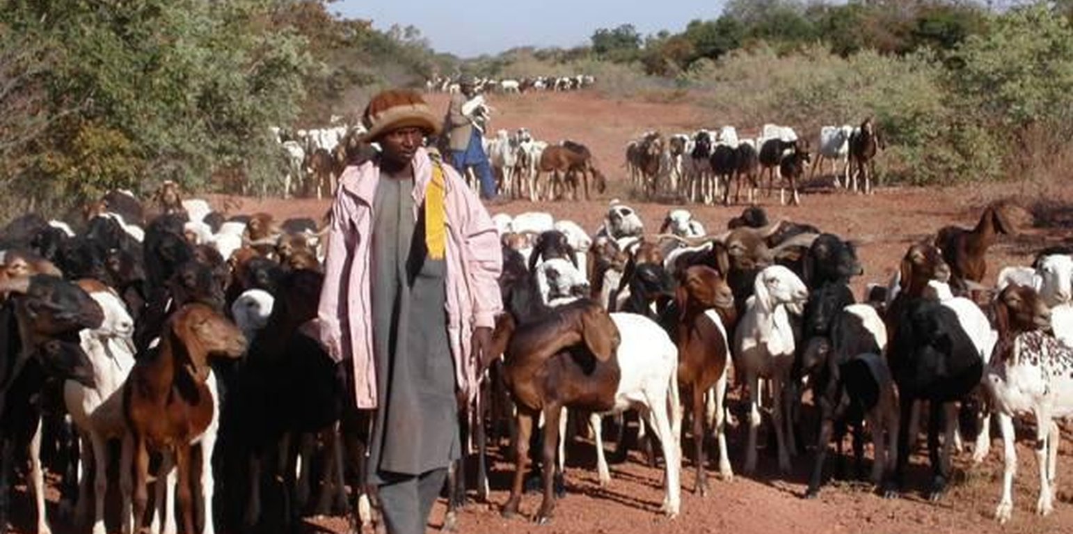
A herd of small ruminants passing a well established couloir (Fodé Boubacar Camara, PAFN)

Couloirs de passage (Niger)

Description

The ‘couloirs de passage’ are formally defined passageways which channel the movements of livestock herds in the agro-pastoral zones of Niger, by linking pastures, water points and coralling areas, be it within village areas (internal couloirs) or on open land (external couloirs).

The main goal of the couloirs is the prevention of conflict between agriculturalists and pastoralists regarding the use of limited land and water resources. These conflicts are often provoked by cattle entering cropping areas. The establishment of demarcated passageways allows the livestock to access water points and pastures without causing damage to cropland. The corridors are regulated through the ‘code rural’ – a national law defining the land use rights of the pastoralists. Demarcation of couloirs is based on a consensual decision of all concerned interest groups. Internal couloirs are negotiated in a general on-site assembly involving all stakeholders (farmers, breeders, women’s groups, local authorities). For the demarcation of external couloirs the involvement of transhumance herders and neighboring villages is indispensable. Once an agreement on the course of the couloir is achieved, demarcation with stones and/or boundary planting with selected tree species is carried out by the local land users - with financial and technical assistance of the government or NGOs. Common species involve: Euphorbia balsamifera, Acacia spp. (A. nilotica; A. senegal); and Faidherbia albida. Management committees at the community level draw up regulations for the management of the couloirs (maintenance and protection of vegetation). Protection of plants is achieved through dead branches (at the initial stage), daily control by forest guards, and information campaigns. The technology is a sustainable solution to the described conflicts. As a valuable by-product the trees along the demarcation lines provide of wood and non-woody by-products.

Location

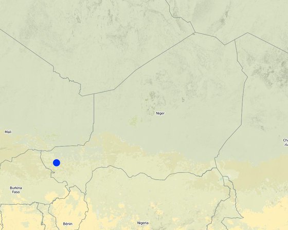
Location: Tillabéri North, Niger

No. of Technology sites analysed:

Geo-reference of selected sites
  • 1.4, 14.1

Spread of the Technology: applied at specific points/ concentrated on a small area

In a permanently protected area?:

Date of implementation:

Type of introduction
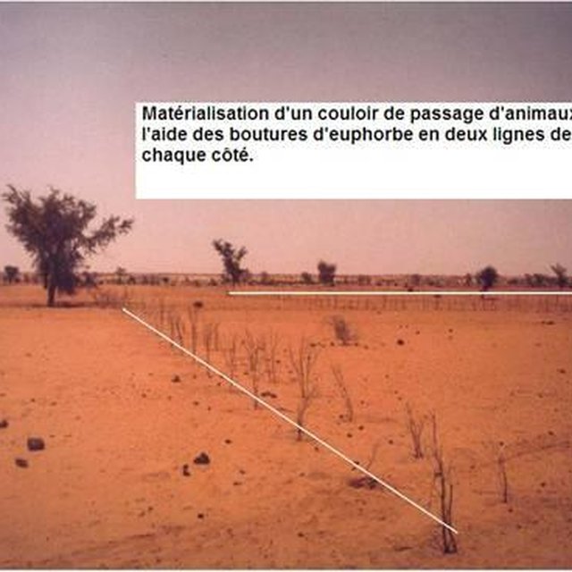
Demarcation of a couloir de passage with two lines of Euphorbia seedlings (LUCOP / Abdoulaye Soumaila)
Finding a consensus on a new couloir de passage in a general assembly involving all stakeholders at community level (Charles Bielders, property of)

Classification of the Technology

Main purpose
  • improve production
  • reduce, prevent, restore land degradation
  • conserve ecosystem
  • protect a watershed/ downstream areas – in combination with other Technologies
  • preserve/ improve biodiversity
  • reduce risk of disasters
  • adapt to climate change/ extremes and its impacts
  • mitigate climate change and its impacts
  • create beneficial economic impact
  • create beneficial social impact
Land use
Land use mixed within the same land unit: Yes - Silvo-pastoralism

  • Grazing land
    • Semi-nomadic pastoralism
  • Forest/ woodlands
Water supply
  • rainfed
  • mixed rainfed-irrigated
  • full irrigation

Purpose related to land degradation
  • prevent land degradation
  • reduce land degradation
  • restore/ rehabilitate severely degraded land
  • adapt to land degradation
  • not applicable
Degradation addressed
  • soil erosion by water - Wt: loss of topsoil/ surface erosion
  • soil erosion by wind - Et: loss of topsoil
  • biological degradation - Bc: reduction of vegetation cover
SLM group
  • pastoralism and grazing land management
SLM measures
  • vegetative measures - V1: Tree and shrub cover
  • management measures - M3: Layout according to natural and human environment

Technical drawing

Technical specifications

Establishment and maintenance: activities, inputs and costs

Calculation of inputs and costs
  • Costs are calculated:
  • Currency used for cost calculation: USD
  • Exchange rate (to USD): 1 USD = n.a
  • Average wage cost of hired labour per day: 1.5
Most important factors affecting the costs
The costs of the planning meeting (general assembly) and the stones for delimitation were not taken into account. Daily salary for field work is US$ 1.5.
Establishment activities
  1. Identification of an existing couloir or definition of a new passageway by means of a general assembly (Timing/ frequency: None)
  2. Alignment of corridor boundaries e.g. by establishing stone lines. Internal couloirs are 10 to 50 m wide, whereas external couloirs exceed a width of 50 m (Timing/ frequency: None)
  3. Digging 40 cm deep pits; tree planting along boundaries (with a spacing of 1-3 meters, depending on the species selected and the secondary objective) (Timing/ frequency: None)
Establishment inputs and costs
Specify input Unit Quantity Costs per Unit (USD) Total costs per input (USD) % of costs borne by land users
Labour
Identification of an existing couloir or definition of a new passageway persons/day 25.0 1.5 37.5 5.0
Plant material
Tree planting along boundaries (seedlings) pieces 670.0 2.05 1373.5 5.0
Total costs for establishment of the Technology 1'411.0
Total costs for establishment of the Technology in USD 1'411.0
Maintenance activities
  1. Protection of trees (through dead branches, guards, information campaigns) (Timing/ frequency: None)
  2. Replanting tree seedlings to fill gaps (annually, beginning of rainy season) (Timing/ frequency: None)
Maintenance inputs and costs
Specify input Unit Quantity Costs per Unit (USD) Total costs per input (USD) % of costs borne by land users
Labour
Protection of trees persons/day 4.0 1.5 6.0 100.0
Plant material
Replanting tree seedlings pieces 67.0 2.0448 137.0 100.0
Total costs for maintenance of the Technology 143.0
Total costs for maintenance of the Technology in USD 143.0

Natural environment

Average annual rainfall
  • < 250 mm
  • 251-500 mm
  • 501-750 mm
  • 751-1,000 mm
  • 1,001-1,500 mm
  • 1,501-2,000 mm
  • 2,001-3,000 mm
  • 3,001-4,000 mm
  • > 4,000 mm
Agro-climatic zone
  • humid
  • sub-humid
  • semi-arid
  • arid
Specifications on climate
Thermal climate class: tropics
Slope
  • flat (0-2%)
  • gentle (3-5%)
  • moderate (6-10%)
  • rolling (11-15%)
  • hilly (16-30%)
  • steep (31-60%)
  • very steep (>60%)
Landforms
  • plateau/plains
  • ridges
  • mountain slopes
  • hill slopes
  • footslopes
  • valley floors
Altitude
  • 0-100 m a.s.l.
  • 101-500 m a.s.l.
  • 501-1,000 m a.s.l.
  • 1,001-1,500 m a.s.l.
  • 1,501-2,000 m a.s.l.
  • 2,001-2,500 m a.s.l.
  • 2,501-3,000 m a.s.l.
  • 3,001-4,000 m a.s.l.
  • > 4,000 m a.s.l.
Technology is applied in
  • convex situations
  • concave situations
  • not relevant
Soil depth
  • very shallow (0-20 cm)
  • shallow (21-50 cm)
  • moderately deep (51-80 cm)
  • deep (81-120 cm)
  • very deep (> 120 cm)
Soil texture (topsoil)
  • coarse/ light (sandy)
  • medium (loamy, silty)
  • fine/ heavy (clay)
Soil texture (> 20 cm below surface)
  • coarse/ light (sandy)
  • medium (loamy, silty)
  • fine/ heavy (clay)
Topsoil organic matter content
  • high (>3%)
  • medium (1-3%)
  • low (<1%)
Groundwater table
  • on surface
  • < 5 m
  • 5-50 m
  • > 50 m
Availability of surface water
  • excess
  • good
  • medium
  • poor/ none
Water quality (untreated)
  • good drinking water
  • poor drinking water (treatment required)
  • for agricultural use only (irrigation)
  • unusable
Is salinity a problem?
  • Yes
  • No

Occurrence of flooding
  • Yes
  • No
Species diversity
  • high
  • medium
  • low
Habitat diversity
  • high
  • medium
  • low

Characteristics of land users applying the Technology

Market orientation
  • subsistence (self-supply)
  • mixed (subsistence/ commercial)
  • commercial/ market
Off-farm income
  • less than 10% of all income
  • 10-50% of all income
  • > 50% of all income
Relative level of wealth
  • very poor
  • poor
  • average
  • rich
  • very rich
Level of mechanization
  • manual work
  • animal traction
  • mechanized/ motorized
Sedentary or nomadic
  • Sedentary
  • Semi-nomadic
  • Nomadic
Individuals or groups
  • individual/ household
  • groups/ community
  • cooperative
  • employee (company, government)
Gender
  • women
  • men
Age
  • children
  • youth
  • middle-aged
  • elderly
Area used per household
  • < 0.5 ha
  • 0.5-1 ha
  • 1-2 ha
  • 2-5 ha
  • 5-15 ha
  • 15-50 ha
  • 50-100 ha
  • 100-500 ha
  • 500-1,000 ha
  • 1,000-10,000 ha
  • > 10,000 ha
Scale
  • small-scale
  • medium-scale
  • large-scale
Land ownership
  • state
  • company
  • communal/ village
  • group
  • individual, not titled
  • individual, titled
Land use rights
  • open access (unorganized)
  • communal (organized)
  • leased
  • individual
Water use rights
  • open access (unorganized)
  • communal (organized)
  • leased
  • individual
Access to services and infrastructure

Impacts

Socio-economic impacts
Crop production
decreased
x
increased

fodder production
decreased
x
increased

fodder quality
decreased
x
increased

animal production
decreased
x
increased

farm income
decreased
x
increased

Socio-cultural impacts
cultural opportunities (eg spiritual, aesthetic, others)
reduced
x
improved

community institutions
weakened
x
strengthened


Through mutual aid in technology implementation

national institutions
weakened
x
strengthened


Code rural secretariat

SLM/ land degradation knowledge
reduced
x
improved

Ecological impacts
soil cover
reduced
x
improved

soil loss
increased
x
decreased

nutrient cycling/ recharge
decreased
x
increased

biomass/ above ground C
decreased
x
increased

animal diversity
decreased
x
increased

fire risk
increased
x
decreased

wind velocity
increased
x
decreased

Off-site impacts
wind transported sediments
increased
x
reduced

damage on neighbours' fields
increased
x
reduced

damage on public/ private infrastructure
increased
x
reduced

Cost-benefit analysis

Benefits compared with establishment costs
Short-term returns
very negative
x
very positive

Long-term returns
very negative
x
very positive

Benefits compared with maintenance costs
Short-term returns
very negative
x
very positive

Long-term returns
very negative
x
very positive

Peace between communities is the key result on short term and on long term. Ecological and economic benefits are linked to the plantation of trees and the improved management of natural resources

Climate change

-

Adoption and adaptation

Percentage of land users in the area who have adopted the Technology
  • single cases/ experimental
  • 1-10%
  • 11-50%
  • > 50%
Of all those who have adopted the Technology, how many have done so without receiving material incentives?
  • 0-10%
  • 11-50%
  • 51-90%
  • 91-100%
Has the Technology been modified recently to adapt to changing conditions?
  • Yes
  • No
To which changing conditions?
  • climatic change/ extremes
  • changing markets
  • labour availability (e.g. due to migration)

Conclusions and lessons learnt

Strengths: land user's view
Strengths: compiler’s or other key resource person’s view
  • The technology provides a sustainable solution to conflicts between agriculturalists and pastoralists
Weaknesses/ disadvantages/ risks: land user's viewhow to overcome
  • Implementation constraints: plant production is very expensive and reaching a consensus on the transformation of private cropland to communal passageways is very difficult definition of the couloirs as public infrastructure and enhancement of organizational capacities of the local population through training and information sessions
  • Maintenance constraints: maintenance can only be realized by adjacent land owners, as the community organizations are weak reinforce the institutional capacities of livestock owners and farmers to manage the couloirs
  • In the pastoral zone the couloirs lead to conflicts between pastoralists and private ranches establish community-based land tenure commissions and introduce new laws on land property in the pastoral zone
Weaknesses/ disadvantages/ risks: compiler’s or other key resource person’s viewhow to overcome

References

Compiler
  • Lemma Ababu
Editors
Reviewer
  • Alexandra Gavilano
Date of documentation: Nov. 11, 2010
Last update: June 6, 2019
Resource persons
Full description in the WOCAT database
Linked SLM data
Documentation was faciliated by
Institution Project
Key references
  • Projet LUCOP/Tillabéry. 2004. Referential des measures techniques de recuperation, de protection et d’exploitation durable des terres, 2nd edition, 2004, 51 pp:
  • Hiernaux P., E. Tielkes, E. Schlecht. 2001. Elevage et gestion des parcours au Sahel, Workshop proceedings organised by Eric Tielkes et Abdoulaye Soumaila, Verlag Ulrich E. Grauer, Beuren, Stuttgart, Germany, 2001:
Links to relevant information which is available online
This work is licensed under Creative Commons Attribution-NonCommercial-ShareaAlike 4.0 International