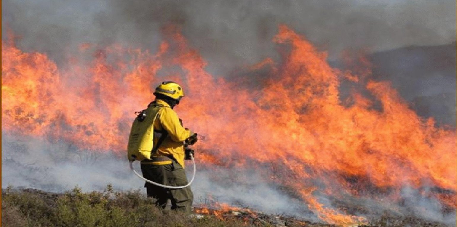
fire fighter monitoring the spread of a prescribed fire

Prescribed fire (Portugal)

Fogo Controlado

Description

Use of prescribed fire (or ‘controlled burn’) to reduce the fuel load in the form of live and dead plant material and thus to prevent the likelihood of more damaging wildfire.

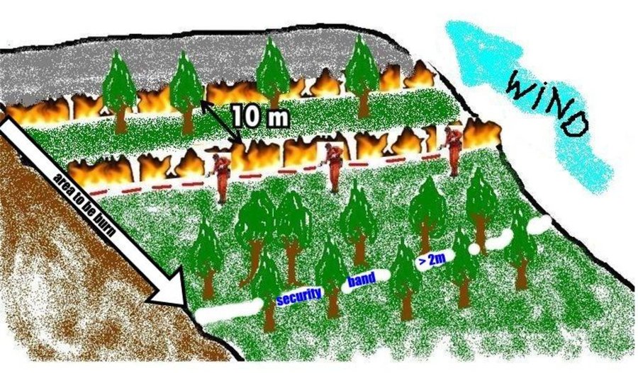
This technique is an essential management tool that applies fire to control the quantity of forest or scrubland fuels. The type of fire depends on the specific goals and on the weather conditions. Firstly, it is important to consider slope angle and the kind of fuels to be burned. Weather conditions include temperature, wind direction and air humidity. Another important aspect is the ability to control the speed of flame spread. In order to carry out the controlled fire, a plan has to be drawn up and approved and a fully-trained, authorised technician must be present in addition to the appropriate support teams (fire fighters, forest management teams). These teams use water or other means of combating the fire in the event of it possibly getting out of control and are in charge of the burning process.

Purpose of the Technology: The main purposes are enhancement of grazing areas and the creation of the so-called primary network for wildfire defence, which is a national network to limit the spread of wildfire. It involves strategically burning key sites (e.g. mountain ridges) to restrict the spread of the wildfire.

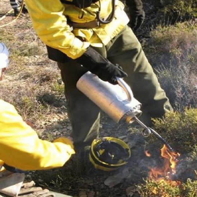
Establishment / maintenance activities and inputs: An analysis of weather conditions is made prior to carry out the prescribed fire. On the day of the prescribed fire itself, safety checks are made and the specific tasks of all the team members are defined. Wind direction and strength need to be minimal and are strictly controlled during burning. The size of the team depends on the specific problems of the area to be treated. Team size needed for about 10 ha is around 10 persons. The team members start along a line working from the top on the mountain along the contour and move downwards. Gentle breeze should be against the direction of the spreading of the fire. Workers use a drip-feed fuel can. There is also a strategy for prescribed fires by burning a strip along ridges of the mountains to avoid spreading of accidental wildfires and to burn in catchments the lowest point from which fire can spread to different areas and spread in different directions on the slopes.

Natural / human environment: Improved grazing management might also reduce the fuel load. Abandoning grazing in the forest can increase the fuel load and aggravate the occurrence and impact of wildfires. The creation or maintenance of grazing areas is determined by the size of the herd. Prescribed fire used as a means of improving grazing enables the local population needs to be addressed while considering environmental concerns. The prescribed fire also helps to protect the local population and their property by reducing the likelihood of devastating wildfire.

Location

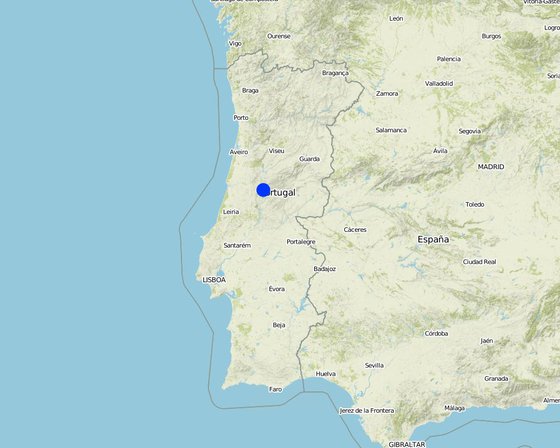
Location: Leiria, Castanheira de Pêra, Portugal

No. of Technology sites analysed:

Geo-reference of selected sites
  • -8.169, 40.0759

Spread of the Technology: evenly spread over an area (0.57 km²)

In a permanently protected area?:

Date of implementation: more than 50 years ago (traditional)

Type of introduction
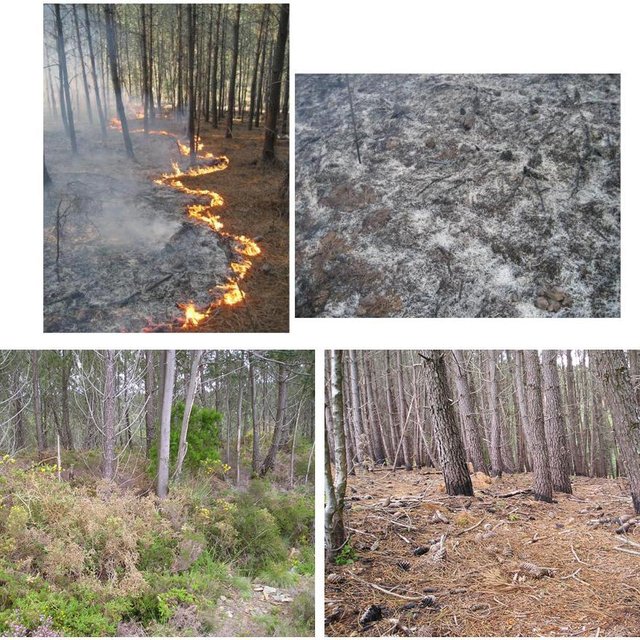
Fuels reduction using prescribed fire technique and final result just after the fire execution (Erik Slingerland)
: a fire torch being prepared in order to start a prescribed fire (Photos: Portuguese

Classification of the Technology

Main purpose
  • improve production
  • reduce, prevent, restore land degradation
  • conserve ecosystem
  • protect a watershed/ downstream areas – in combination with other Technologies
  • preserve/ improve biodiversity
  • reduce risk of disasters
  • adapt to climate change/ extremes and its impacts
  • mitigate climate change and its impacts
  • create beneficial economic impact
  • create beneficial social impact
Land use

  • Grazing land
    • Semi-nomadic pastoralism
  • Forest/ woodlandsProducts and services: Timber, Grazing/ browsing
Water supply
  • rainfed
  • mixed rainfed-irrigated
  • full irrigation

Purpose related to land degradation
  • prevent land degradation
  • reduce land degradation
  • restore/ rehabilitate severely degraded land
  • adapt to land degradation
  • not applicable
Degradation addressed
  • biological degradation - Bf: detrimental effects of fires
SLM group
  • natural and semi-natural forest management
  • Prescribed fire
SLM measures
  • management measures - M5: Control/ change of species composition

Technical drawing

Technical specifications
Prescribed fire is a practice used to manage vegetation in wildfire-prone areas. It consists of slowly burning strategic areas in the wet season, under specific weather and ground conditions and procedures: the soil should be moist, burning typically carried out in thin strips (normally 10m distance between two fire lines) from the top to the bottom of the slope, there should be only a gentle breeze blowing upslope and the ignition points should be 2m apart along the contour. The fire is allowed to progress downslope against the wind, which therefore provides some control. Burning is achieved by a number of the team who are prepared to dowse the flames if the fire gets out of hand. This degree of control is only possible when burning small areas with the same slope angle.

Location: Castanheira de Pêra. Leiria, Portugal

Date: January, 2009

Technical knowledge required for field staff / advisors: high (Specific training)

Technical knowledge required for land users: low

Technical knowledge required for Fire men: moderate

Main technical functions: control of fires, reduction of dry material (fuel for wildfires), spatial arrangement and diversification of land use

Secondary technical functions: control of dispersed runoff: impede / retard, increase of infiltration

Layout change according to natural and human environment
Author: Adapted from Pedro Palheiro

Establishment and maintenance: activities, inputs and costs

Calculation of inputs and costs
  • Costs are calculated:
  • Currency used for cost calculation: EURO
  • Exchange rate (to USD): 1 USD = 136.94 EURO
  • Average wage cost of hired labour per day: 100.00
Most important factors affecting the costs
Prescribed fire costs: timing, the right number in the team, fuel type and specific local conditions (slope and vegetation) are the most important determining factors affecting the costs.
Establishment activities
  1. Planning and implementation (Timing/ frequency: 1 morning (5h))
  2. Fire control equipment (Timing/ frequency: None)
  3. Monitoring prescribed fire (Timing/ frequency: 1 morning (5h))
Establishment inputs and costs
Specify input Unit Quantity Costs per Unit (EURO) Total costs per input (EURO) % of costs borne by land users
Labour
Labour ha 1.0 25.0 25.0
Equipment
Machine use ha 1.0 25.0 25.0
Total costs for establishment of the Technology 50.0
Total costs for establishment of the Technology in USD 0.37
Maintenance activities
  1. No maintenance is necessary. Every 3 to 5 years, prescribed fire is carried out again, repeating the process described abovet. (Timing/ frequency: On 3-4 or 4-5 years)

Natural environment

Average annual rainfall
  • < 250 mm
  • 251-500 mm
  • 501-750 mm
  • 751-1,000 mm
  • 1,001-1,500 mm
  • 1,501-2,000 mm
  • 2,001-3,000 mm
  • 3,001-4,000 mm
  • > 4,000 mm
Agro-climatic zone
  • humid
  • sub-humid
  • semi-arid
  • arid
Specifications on climate
Thermal climate class: temperate
Slope
  • flat (0-2%)
  • gentle (3-5%)
  • moderate (6-10%)
  • rolling (11-15%)
  • hilly (16-30%)
  • steep (31-60%)
  • very steep (>60%)
Landforms
  • plateau/plains
  • ridges
  • mountain slopes
  • hill slopes
  • footslopes
  • valley floors
Altitude
  • 0-100 m a.s.l.
  • 101-500 m a.s.l.
  • 501-1,000 m a.s.l.
  • 1,001-1,500 m a.s.l.
  • 1,501-2,000 m a.s.l.
  • 2,001-2,500 m a.s.l.
  • 2,501-3,000 m a.s.l.
  • 3,001-4,000 m a.s.l.
  • > 4,000 m a.s.l.
Technology is applied in
  • convex situations
  • concave situations
  • not relevant
Soil depth
  • very shallow (0-20 cm)
  • shallow (21-50 cm)
  • moderately deep (51-80 cm)
  • deep (81-120 cm)
  • very deep (> 120 cm)
Soil texture (topsoil)
  • coarse/ light (sandy)
  • medium (loamy, silty)
  • fine/ heavy (clay)
Soil texture (> 20 cm below surface)
  • coarse/ light (sandy)
  • medium (loamy, silty)
  • fine/ heavy (clay)
Topsoil organic matter content
  • high (>3%)
  • medium (1-3%)
  • low (<1%)
Groundwater table
  • on surface
  • < 5 m
  • 5-50 m
  • > 50 m
Availability of surface water
  • excess
  • good
  • medium
  • poor/ none
Water quality (untreated)
  • good drinking water
  • poor drinking water (treatment required)
  • for agricultural use only (irrigation)
  • unusable
Water quality refers to:
Is salinity a problem?
  • Yes
  • No

Occurrence of flooding
  • Yes
  • No
Species diversity
  • high
  • medium
  • low
Habitat diversity
  • high
  • medium
  • low

Characteristics of land users applying the Technology

Market orientation
  • subsistence (self-supply)
  • mixed (subsistence/ commercial)
  • commercial/ market
Off-farm income
  • less than 10% of all income
  • 10-50% of all income
  • > 50% of all income
Relative level of wealth
  • very poor
  • poor
  • average
  • rich
  • very rich
Level of mechanization
  • manual work
  • animal traction
  • mechanized/ motorized
Sedentary or nomadic
  • Sedentary
  • Semi-nomadic
  • Nomadic
Individuals or groups
  • individual/ household
  • groups/ community
  • cooperative
  • employee (company, government)
Gender
  • women
  • men
Age
  • children
  • youth
  • middle-aged
  • elderly
Area used per household
  • < 0.5 ha
  • 0.5-1 ha
  • 1-2 ha
  • 2-5 ha
  • 5-15 ha
  • 15-50 ha
  • 50-100 ha
  • 100-500 ha
  • 500-1,000 ha
  • 1,000-10,000 ha
  • > 10,000 ha
Scale
  • small-scale
  • medium-scale
  • large-scale
Land ownership
  • state
  • company
  • communal/ village
  • group
  • individual, not titled
  • individual, titled
Land use rights
  • open access (unorganized)
  • communal (organized)
  • leased
  • individual
Water use rights
  • open access (unorganized)
  • communal (organized)
  • leased
  • individual
Access to services and infrastructure
health

poor
x
good
education

poor
x
good
technical assistance

poor
x
good
employment (e.g. off-farm)

poor
x
good
markets

poor
x
good
energy

poor
x
good
roads and transport

poor
x
good
drinking water and sanitation

poor
x
good
financial services

poor
x
good

Impacts

Socio-economic impacts
fodder production
decreased
x
increased


Under investigation.

fodder quality
decreased
x
increased

risk of production failure
increased
x
decreased

drinking water availability
decreased
x
increased

drinking water quality
decreased
x
increased

Socio-cultural impacts
food security/ self-sufficiency
reduced
x
improved

cultural opportunities (eg spiritual, aesthetic, others)
reduced
x
improved

recreational opportunities
reduced
x
improved

community institutions
weakened
x
strengthened

national institutions
weakened
x
strengthened

Improved livelihoods and human well-being
None
x
None


There are not direct improves on livelihoods, they are the results of the prevention of forest fires.

Ecological impacts
water quality
decreased
x
increased


if decreased: Resulting from rainfall infiltration that will carry out pollutants and contaminate water recharge.

surface runoff
increased
x
decreased

soil moisture
decreased
x
increased

soil cover
reduced
x
improved

soil loss
increased
x
decreased

soil crusting/ sealing
increased
x
reduced

nutrient cycling/ recharge
decreased
x
increased

plant diversity
decreased
x
increased

invasive alien species
increased
x
reduced

animal diversity
decreased
x
increased

beneficial species (predators, earthworms, pollinators)
decreased
x
increased

habitat diversity
decreased
x
increased

pest/ disease control
decreased
x
increased

fire risk
increased
x
decreased


Avoid extreme/catastrophic events of hot fires

Off-site impacts
reliable and stable stream flows in dry season (incl. low flows)
reduced
x
increased

downstream flooding (undesired)
increased
x
reduced

downstream siltation
increased
x
decreased

buffering/ filtering capacity (by soil, vegetation, wetlands)
reduced
x
improved

wind transported sediments
increased
x
reduced

damage on neighbours' fields
increased
x
reduced

damage on public/ private infrastructure
increased
x
reduced

Cost-benefit analysis

Benefits compared with establishment costs
Short-term returns
very negative
x
very positive

Long-term returns
very negative
x
very positive

Benefits compared with maintenance costs
The major benefit it is to prevent fores fires by reducing fuel quantities. A second benefit it is the increase of pasture on the next years that will be available to animals.

Climate change

Climate-related extremes (disasters)
drought

not well at all
x
very well
Other climate-related consequences
wheather conditions

not well at all
x
very well

Adoption and adaptation

Percentage of land users in the area who have adopted the Technology
  • single cases/ experimental
  • 1-10%
  • 11-50%
  • > 50%
Of all those who have adopted the Technology, how many have done so without receiving material incentives?
  • 0-10%
  • 11-50%
  • 51-90%
  • 91-100%
Has the Technology been modified recently to adapt to changing conditions?
  • Yes
  • No
To which changing conditions?
  • climatic change/ extremes
  • changing markets
  • labour availability (e.g. due to migration)

Conclusions and lessons learnt

Strengths: land user's view
Strengths: compiler’s or other key resource person’s view
  • The vegetation is adapted to the fire – impact minimization.

    How can they be sustained / enhanced? ore use of controlled fires.
  • With prescribed burning, larger areas can be treated compared to other fire control techniques, limited to strips in strategic areas, which are so difficult and expensive, whereas with prescribed burning, there is effective control of the vegetation over a large area”.

    How can they be sustained / enhanced? continue the use of controlled burning.
  • Difficult operating conditions and high costs make the technology unsuitable for certain areas costs

    How can they be sustained / enhanced? continued use of the controlled fire technique instead of other techniques.
  • It is cheaper than other control measures, for instance mechanical ones
  • In comparison with other techniques that manage biomass, this technique is more conservational, and it is culturally embedded in the local population way of life. It contributes to landscape diversification and the development of the local economy. It introduces fire as an essential feature of the Mediterranean landscape in a controlled manner.
Weaknesses/ disadvantages/ risks: land user's viewhow to overcome
Weaknesses/ disadvantages/ risks: compiler’s or other key resource person’s viewhow to overcome
  • Air pollution ensure that the wind direction does not carry smoke over settlements. However, it is not possible to eliminate the smoke problem. In particular, a certain degree of moisture is required in the fuel load to enable the fire to be controlled, in order that the burning temperature is low and this tends to produce smoke.
  • Lack of knowledge of people living near the burnt areas improved education via schools, community meetings and in pamphlets.
  • Possibility of the control loss of the prescribed fire care needed to prevent this happening.
  • Safety of the personnel carrying out the burn conduct risk assessment exercises, carry out detailed planning and only apply the technology under the right weather conditions

References

Compiler
  • Manuela Carreiras
Editors
Reviewer
  • Deborah Niggli
  • Alexandra Gavilano
Date of documentation: July 1, 2011
Last update: June 14, 2019
Resource persons
Full description in the WOCAT database
Linked SLM data
Documentation was faciliated by
Institution Project
Key references
  • Fernandes, P., Botelho, H., Loureiro, C. 2002. Manual de formação para a técnica do fogo controlado. CNEFF, UTAD, Maio de 2002:
This work is licensed under Creative Commons Attribution-NonCommercial-ShareaAlike 4.0 International