Prescribed fire [Portugal]
- Creation:
- Update:
- Compiler: Manuela Carreiras
- Editor: –
- Reviewers: Deborah Niggli, Alexandra Gavilano
Fogo Controlado
technologies_1534 - Portugal
View sections
Expand all Collapse all1. General information
1.2 Contact details of resource persons and institutions involved in the assessment and documentation of the Technology
SLM specialist:
Name of project which facilitated the documentation/ evaluation of the Technology (if relevant)
DESIRE (EU-DES!RE)Name of the institution(s) which facilitated the documentation/ evaluation of the Technology (if relevant)
Centro de Estudos de Rescursos Naturais, Ambiente e Sociedade (CERNAS) - Portugal1.3 Conditions regarding the use of data documented through WOCAT
The compiler and key resource person(s) accept the conditions regarding the use of data documented through WOCAT:
Yes
1.5 Reference to Questionnaire(s) on SLM Approaches (documented using WOCAT)
Forest Intervention Area (ZIF) [Portugal]
Forest Intervention Area (ZIF) is a territorial unit, where the main land use is forestry. This approach assembles and organizes small forest holders and defines a joint intervention for forest management and protection. Defined by law in 2005, and revised in 2009, each ZIF of private forest has to include …
- Compiler: Celeste Coelho
2. Description of the SLM Technology
2.1 Short description of the Technology
Definition of the Technology:
Use of prescribed fire (or ‘controlled burn’) to reduce the fuel load in the form of live and dead plant material and thus to prevent the likelihood of more damaging wildfire.
2.2 Detailed description of the Technology
Description:
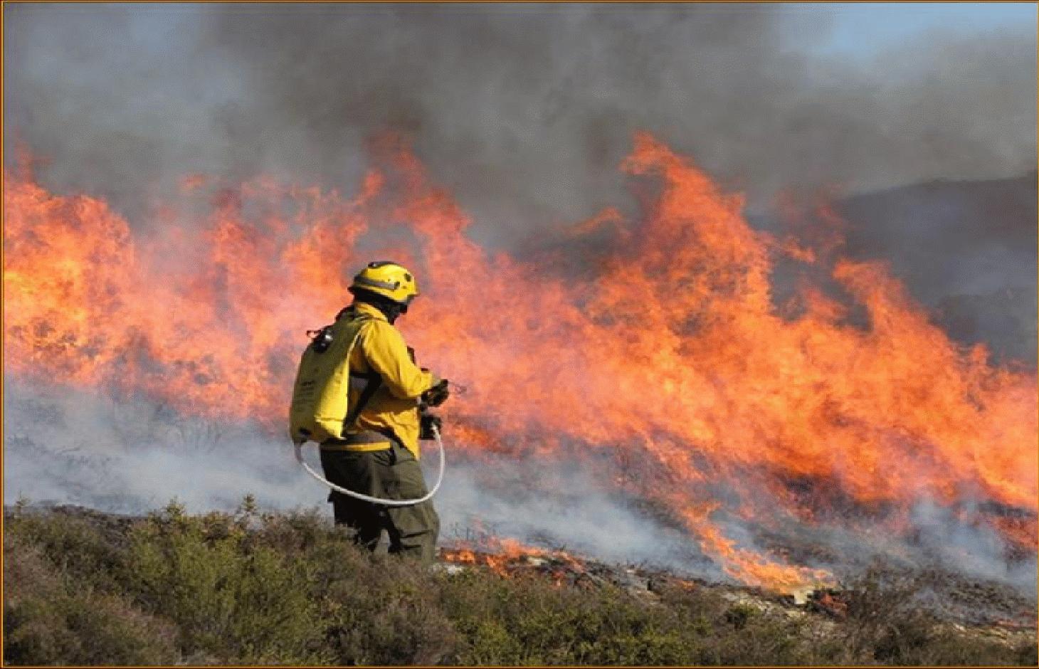
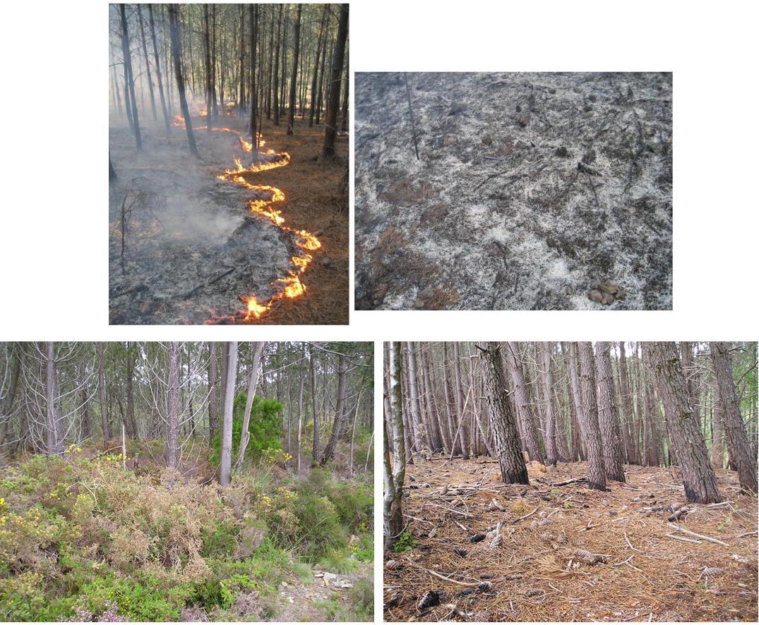
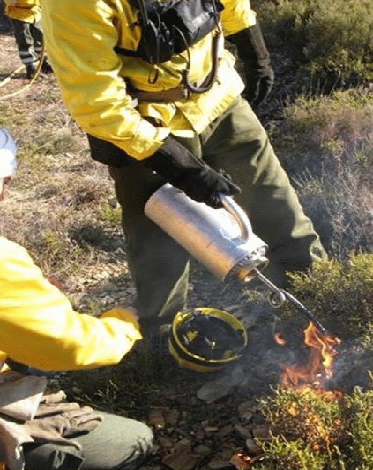
This technique is an essential management tool that applies fire to control the quantity of forest or scrubland fuels. The type of fire depends on the specific goals and on the weather conditions. Firstly, it is important to consider slope angle and the kind of fuels to be burned. Weather conditions include temperature, wind direction and air humidity. Another important aspect is the ability to control the speed of flame spread. In order to carry out the controlled fire, a plan has to be drawn up and approved and a fully-trained, authorised technician must be present in addition to the appropriate support teams (fire fighters, forest management teams). These teams use water or other means of combating the fire in the event of it possibly getting out of control and are in charge of the burning process.
Purpose of the Technology: The main purposes are enhancement of grazing areas and the creation of the so-called primary network for wildfire defence, which is a national network to limit the spread of wildfire. It involves strategically burning key sites (e.g. mountain ridges) to restrict the spread of the wildfire.
Establishment / maintenance activities and inputs: An analysis of weather conditions is made prior to carry out the prescribed fire. On the day of the prescribed fire itself, safety checks are made and the specific tasks of all the team members are defined. Wind direction and strength need to be minimal and are strictly controlled during burning. The size of the team depends on the specific problems of the area to be treated. Team size needed for about 10 ha is around 10 persons. The team members start along a line working from the top on the mountain along the contour and move downwards. Gentle breeze should be against the direction of the spreading of the fire. Workers use a drip-feed fuel can. There is also a strategy for prescribed fires by burning a strip along ridges of the mountains to avoid spreading of accidental wildfires and to burn in catchments the lowest point from which fire can spread to different areas and spread in different directions on the slopes.
Natural / human environment: Improved grazing management might also reduce the fuel load. Abandoning grazing in the forest can increase the fuel load and aggravate the occurrence and impact of wildfires. The creation or maintenance of grazing areas is determined by the size of the herd. Prescribed fire used as a means of improving grazing enables the local population needs to be addressed while considering environmental concerns. The prescribed fire also helps to protect the local population and their property by reducing the likelihood of devastating wildfire.
2.3 Photos of the Technology
Media Gallery
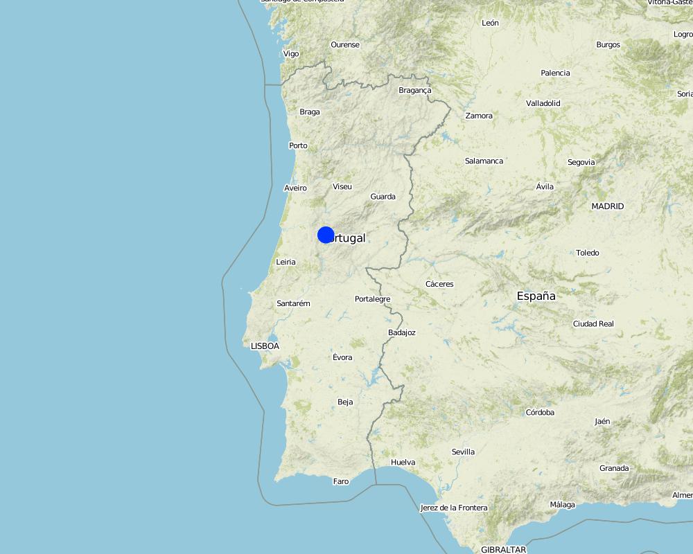
2.5 Country/ region/ locations where the Technology has been applied and which are covered by this assessment
Country:
Portugal
Region/ State/ Province:
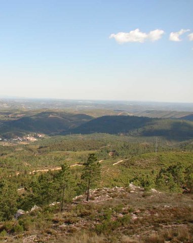
Castanheira de Pêra
Further specification of location:
Leiria
Specify the spread of the Technology:
- evenly spread over an area
If the Technology is evenly spread over an area, specify area covered (in km2):
0.57
Comments:
Total area covered by the SLM Technology is 0.57 km2.
Map
×2.6 Date of implementation
If precise year is not known, indicate approximate date:
- more than 50 years ago (traditional)
2.7 Introduction of the Technology
Specify how the Technology was introduced:
- as part of a traditional system (> 50 years)
3. Classification of the SLM Technology
3.2 Current land use type(s) where the Technology is applied

Grazing land
Extensive grazing:
- Semi-nomadic pastoralism

Forest/ woodlands
- Shrublands/pasture
Products and services:
- Timber
- Grazing/ browsing
Comments:
Major land use problems (compiler’s opinion): The problem is linked to the loss of traditional natural pasture use. Since there is nowadays no grazing/pasture use of forests, the fuel load remains uncontrolled. It is also linked to minimising wildfire impacts and the creation of grazing land. As more people visit forest areas for leisure and accidentally set fire. Another problem is vandalism and arson.
Semi-nomadism / pastoralism: Yes
Other type of forest: Shrublands/pasture
Forest products and services: timber, grazing / browsing
Livestock density: < 1 LU/km2
3.4 Water supply
Water supply for the land on which the Technology is applied:
- rainfed
3.5 SLM group to which the Technology belongs
- natural and semi-natural forest management
- Prescribed fire
3.6 SLM measures comprising the Technology

management measures
- M5: Control/ change of species composition
Comments:
Main measures: management measures
3.7 Main types of land degradation addressed by the Technology

biological degradation
- Bf: detrimental effects of fires
Comments:
Main type of degradation addressed: Bf: detrimental effects of fires
Main causes of degradation: deforestation / removal of natural vegetation (incl. forest fires), other natural causes (avalanches, volcanic eruptions, mud flows, highly susceptible natural resources, extreme topography, etc.) specify (Wildfire), population pressure (An decline of population during the last decades resulting in less grazing contributes to increased wildfire risk.)
3.8 Prevention, reduction, or restoration of land degradation
Specify the goal of the Technology with regard to land degradation:
- reduce land degradation
Comments:
Main goals: mitigation / reduction of land degradation
4. Technical specifications, implementation activities, inputs, and costs
4.1 Technical drawing of the Technology
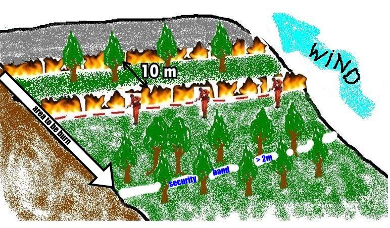
Technical specifications (related to technical drawing):
Prescribed fire is a practice used to manage vegetation in wildfire-prone areas. It consists of slowly burning strategic areas in the wet season, under specific weather and ground conditions and procedures: the soil should be moist, burning typically carried out in thin strips (normally 10m distance between two fire lines) from the top to the bottom of the slope, there should be only a gentle breeze blowing upslope and the ignition points should be 2m apart along the contour. The fire is allowed to progress downslope against the wind, which therefore provides some control. Burning is achieved by a number of the team who are prepared to dowse the flames if the fire gets out of hand. This degree of control is only possible when burning small areas with the same slope angle.
Location: Castanheira de Pêra. Leiria, Portugal
Date: January, 2009
Technical knowledge required for field staff / advisors: high (Specific training)
Technical knowledge required for land users: low
Technical knowledge required for Fire men: moderate
Main technical functions: control of fires, reduction of dry material (fuel for wildfires), spatial arrangement and diversification of land use
Secondary technical functions: control of dispersed runoff: impede / retard, increase of infiltration
Layout change according to natural and human environment
Author:
Adapted from Pedro Palheiro
4.2 General information regarding the calculation of inputs and costs
other/ national currency (specify):
EURO
If relevant, indicate exchange rate from USD to local currency (e.g. 1 USD = 79.9 Brazilian Real): 1 USD =:
136.94
Indicate average wage cost of hired labour per day:
100.00
4.3 Establishment activities
| Activity | Timing (season) | |
|---|---|---|
| 1. | Planning and implementation | 1 morning (5h) |
| 2. | Fire control equipment | |
| 3. | Monitoring prescribed fire | 1 morning (5h) |
4.4 Costs and inputs needed for establishment
| Specify input | Unit | Quantity | Costs per Unit | Total costs per input | % of costs borne by land users | |
|---|---|---|---|---|---|---|
| Labour | Labour | ha | 1.0 | 25.0 | 25.0 | |
| Equipment | Machine use | ha | 1.0 | 25.0 | 25.0 | |
| Total costs for establishment of the Technology | 50.0 | |||||
| Total costs for establishment of the Technology in USD | 0.37 | |||||
4.5 Maintenance/ recurrent activities
| Activity | Timing/ frequency | |
|---|---|---|
| 1. | No maintenance is necessary. Every 3 to 5 years, prescribed fire is carried out again, repeating the process described abovet. | On 3-4 or 4-5 years |
4.6 Costs and inputs needed for maintenance/ recurrent activities (per year)
Comments:
Calculation of costs has been made based on the prescribed fire conducted for the DESIRE project. They represent the costs to burn 3-4ha, during a morning and including human resources (12 people), equipment (fire torch, fuel, special fire protection clothing, scythes, and hoses) and specialized fire fighting vehicles.
4.7 Most important factors affecting the costs
Describe the most determinate factors affecting the costs:
Prescribed fire costs: timing, the right number in the team, fuel type and specific local conditions (slope and vegetation) are the most important determining factors affecting the costs.
5. Natural and human environment
5.1 Climate
Annual rainfall
- < 250 mm
- 251-500 mm
- 501-750 mm
- 751-1,000 mm
- 1,001-1,500 mm
- 1,501-2,000 mm
- 2,001-3,000 mm
- 3,001-4,000 mm
- > 4,000 mm
Agro-climatic zone
- sub-humid
Thermal climate class: temperate
5.2 Topography
Slopes on average:
- flat (0-2%)
- gentle (3-5%)
- moderate (6-10%)
- rolling (11-15%)
- hilly (16-30%)
- steep (31-60%)
- very steep (>60%)
Landforms:
- plateau/plains
- ridges
- mountain slopes
- hill slopes
- footslopes
- valley floors
Altitudinal zone:
- 0-100 m a.s.l.
- 101-500 m a.s.l.
- 501-1,000 m a.s.l.
- 1,001-1,500 m a.s.l.
- 1,501-2,000 m a.s.l.
- 2,001-2,500 m a.s.l.
- 2,501-3,000 m a.s.l.
- 3,001-4,000 m a.s.l.
- > 4,000 m a.s.l.
5.3 Soils
Soil depth on average:
- very shallow (0-20 cm)
- shallow (21-50 cm)
- moderately deep (51-80 cm)
- deep (81-120 cm)
- very deep (> 120 cm)
Soil texture (topsoil):
- coarse/ light (sandy)
- medium (loamy, silty)
Topsoil organic matter:
- low (<1%)
5.4 Water availability and quality
Ground water table:
> 50 m
Availability of surface water:
poor/ none
Water quality (untreated):
good drinking water
5.5 Biodiversity
Species diversity:
- medium
5.6 Characteristics of land users applying the Technology
Market orientation of production system:
- subsistence (self-supply)
- mixed (subsistence/ commercial)
Relative level of wealth:
- poor
- average
Individuals or groups:
- employee (company, government)
Indicate other relevant characteristics of the land users:
Population density: < 10 persons/km2
Annual population growth: negative
25% of the land users are average wealthy.
75% of the land users are poor.
Market orientation of production system: Mixed (for example, mechanised agroforestry) Wild fire risk reduction
5.7 Average area of land used by land users applying the Technology
- < 0.5 ha
- 0.5-1 ha
- 1-2 ha
- 2-5 ha
- 5-15 ha
- 15-50 ha
- 50-100 ha
- 100-500 ha
- 500-1,000 ha
- 1,000-10,000 ha
- > 10,000 ha
Comments:
Average area of land owned or leased by land users applying the Technology: 0.5-1 ha, 0.5-1 ha, 2-5 ha
5.8 Land ownership, land use rights, and water use rights
Land ownership:
- communal/ village
Land use rights:
- communal (organized)
Water use rights:
- open access (unorganized)
5.9 Access to services and infrastructure
health:
- poor
- moderate
- good
education:
- poor
- moderate
- good
technical assistance:
- poor
- moderate
- good
employment (e.g. off-farm):
- poor
- moderate
- good
markets:
- poor
- moderate
- good
energy:
- poor
- moderate
- good
roads and transport:
- poor
- moderate
- good
drinking water and sanitation:
- poor
- moderate
- good
financial services:
- poor
- moderate
- good
6. Impacts and concluding statements
6.1 On-site impacts the Technology has shown
Socio-economic impacts
Production
fodder production
Comments/ specify:
Under investigation.
fodder quality
risk of production failure
Water availability and quality
drinking water availability
drinking water quality
Socio-cultural impacts
food security/ self-sufficiency
cultural opportunities
recreational opportunities
community institutions
national institutions
Improved livelihoods and human well-being
Comments/ specify:
There are not direct improves on livelihoods, they are the results of the prevention of forest fires.
Ecological impacts
Water cycle/ runoff
water quality
Comments/ specify:
if decreased: Resulting from rainfall infiltration that will carry out pollutants and contaminate water recharge.
surface runoff
Soil
soil moisture
soil cover
soil loss
soil crusting/ sealing
nutrient cycling/ recharge
Biodiversity: vegetation, animals
plant diversity
invasive alien species
animal diversity
beneficial species
habitat diversity
pest/ disease control
Climate and disaster risk reduction
fire risk
Comments/ specify:
Avoid extreme/catastrophic events of hot fires
6.2 Off-site impacts the Technology has shown
reliable and stable stream flows in dry season
downstream flooding
downstream siltation
buffering/ filtering capacity
wind transported sediments
damage on neighbours' fields
damage on public/ private infrastructure
6.3 Exposure and sensitivity of the Technology to gradual climate change and climate-related extremes/ disasters (as perceived by land users)
Climate-related extremes (disasters)
Climatological disasters
| How does the Technology cope with it? | |
|---|---|
| drought | well |
Other climate-related consequences
Other climate-related consequences
| How does the Technology cope with it? | |
|---|---|
| wheather conditions | not well |
Comments:
As a result of the characteristics of the technique, it is not possible to make modifications except to select the right weather conditions and the fuel load.
6.4 Cost-benefit analysis
How do the benefits compare with the establishment costs (from land users’ perspective)?
Short-term returns:
very positive
Long-term returns:
very positive
Comments:
The major benefit it is to prevent fores fires by reducing fuel quantities. A second benefit it is the increase of pasture on the next years that will be available to animals.
6.5 Adoption of the Technology
Comments:
There is a strong trend towards spontaneous adoption of the Technology
Comments on adoption trend: In vulnerable areas, there is a need for reduction of the fuel load, removal of the vegetative cover or promotion of new plant growth.
6.7 Strengths/ advantages/ opportunities of the Technology
| Strengths/ advantages/ opportunities in the compiler’s or other key resource person’s view |
|---|
|
The vegetation is adapted to the fire – impact minimization. How can they be sustained / enhanced? ore use of controlled fires. |
|
With prescribed burning, larger areas can be treated compared to other fire control techniques, limited to strips in strategic areas, which are so difficult and expensive, whereas with prescribed burning, there is effective control of the vegetation over a large area”. How can they be sustained / enhanced? continue the use of controlled burning. |
|
Difficult operating conditions and high costs make the technology unsuitable for certain areas costs How can they be sustained / enhanced? continued use of the controlled fire technique instead of other techniques. |
| It is cheaper than other control measures, for instance mechanical ones |
| In comparison with other techniques that manage biomass, this technique is more conservational, and it is culturally embedded in the local population way of life. It contributes to landscape diversification and the development of the local economy. It introduces fire as an essential feature of the Mediterranean landscape in a controlled manner. |
6.8 Weaknesses/ disadvantages/ risks of the Technology and ways of overcoming them
| Weaknesses/ disadvantages/ risks in the compiler’s or other key resource person’s view | How can they be overcome? |
|---|---|
| Air pollution | ensure that the wind direction does not carry smoke over settlements. However, it is not possible to eliminate the smoke problem. In particular, a certain degree of moisture is required in the fuel load to enable the fire to be controlled, in order that the burning temperature is low and this tends to produce smoke. |
| Lack of knowledge of people living near the burnt areas | improved education via schools, community meetings and in pamphlets. |
| Possibility of the control loss of the prescribed fire | care needed to prevent this happening. |
| Safety of the personnel carrying out the burn | conduct risk assessment exercises, carry out detailed planning and only apply the technology under the right weather conditions |
7. References and links
7.1 Methods/ sources of information
7.2 References to available publications
Title, author, year, ISBN:
Fernandes, P., Botelho, H., Loureiro, C. 2002. Manual de formação para a técnica do fogo controlado. CNEFF, UTAD, Maio de 2002
Links and modules
Expand all Collapse allLinks
Forest Intervention Area (ZIF) [Portugal]
Forest Intervention Area (ZIF) is a territorial unit, where the main land use is forestry. This approach assembles and organizes small forest holders and defines a joint intervention for forest management and protection. Defined by law in 2005, and revised in 2009, each ZIF of private forest has to include …
- Compiler: Celeste Coelho
Modules
No modules