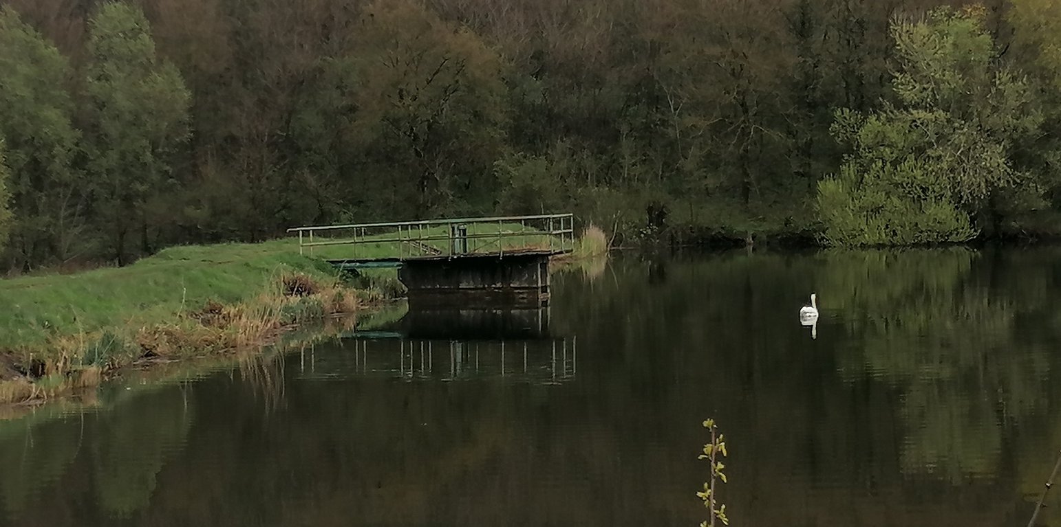
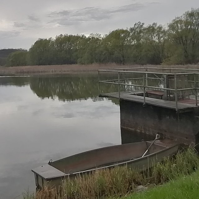
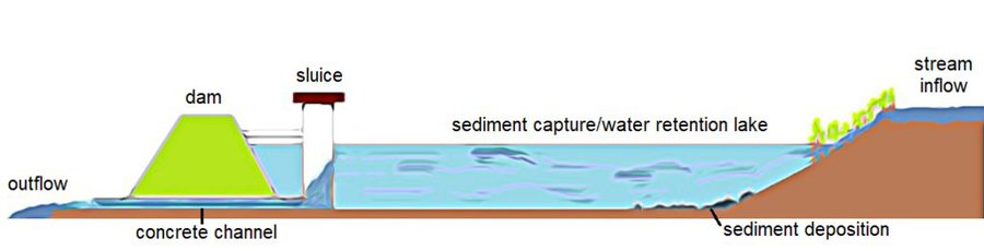
Sediment capture ponds are built on the stream carrying water from the catchment area (Piroska Kassai)

Water retention/sediment capture pond (Hungary)

Víztározó/üledékfelfogó tó

Description

Sediment capture ponds are constructed and located along networks of ditches which drain watersheds. They slow the velocity of water and cause the deposition of suspended materials. These ponds help to avoid sediment accumulation in the ditches themselves, and can decrease sediment and nutrient pollution of surface water bodies downstream.

Sediment capture ponds are designed to be able to retain runoff water during rainy periods. They are located along networks of ditches which drain watersheds – and are constructed through mechanical excavation. The technology is usually applied in hilly areas, but sometimes downstream ponds are located in or near urban zones. The ponds slow the velocity of water and cause deposition of suspended materials. They help to avoid sediment accumulation in the ditches themselves, and can decrease sediment and nutrient pollution of surface water bodies downstream. Water retention in the upstream area results in better infiltration and provides a source of water for wildlife. As sediment is regularly deposited in the ponds, they need to be desilted to maintain effectiveness.

Location

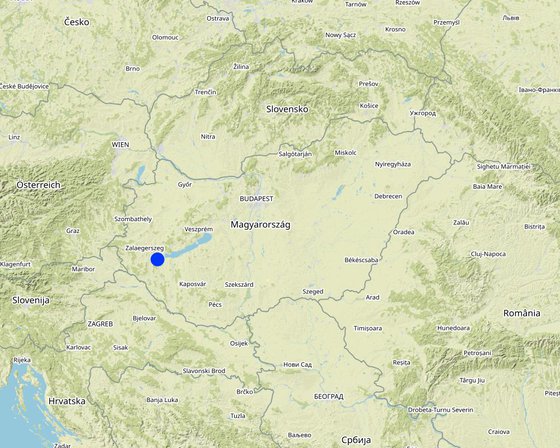
Location: Esztergályhorváti, Zala County, Hungary

No. of Technology sites analysed: single site

Geo-reference of selected sites
  • 17.09655, 46.69078

Spread of the Technology: applied at specific points/ concentrated on a small area

In a permanently protected area?: No

Date of implementation: 10-50 years ago

Type of introduction
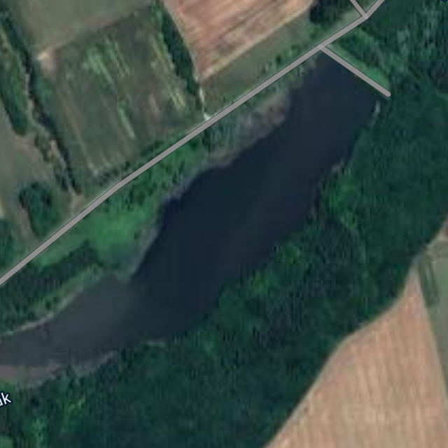
Water retention/sediment capture pond
Water retention/sediment capture pond (Piroska Kassai)

Classification of the Technology

Main purpose
  • improve production
  • reduce, prevent, restore land degradation
  • conserve ecosystem
  • protect a watershed/ downstream areas – in combination with other Technologies
  • preserve/ improve biodiversity
  • reduce risk of disasters
  • adapt to climate change/ extremes and its impacts
  • mitigate climate change and its impacts
  • create beneficial economic impact
  • create beneficial social impact
Land use
Land use mixed within the same land unit: No

  • Cropland
    • Annual cropping: cereals - barley, cereals - maize, cereals - wheat (winter), oilseed crops - sunflower, rapeseed, other
    Number of growing seasons per year: 1
    Is intercropping practiced? Yes
    Is crop rotation practiced? Yes
Water supply
  • rainfed
  • mixed rainfed-irrigated
  • full irrigation

Purpose related to land degradation
  • prevent land degradation
  • reduce land degradation
  • restore/ rehabilitate severely degraded land
  • adapt to land degradation
  • not applicable
Degradation addressed
  • water degradation - Hp: decline of surface water quality
SLM group
  • water harvesting
  • surface water management (spring, river, lakes, sea)
  • wetland protection/ management
SLM measures
  • structural measures - S5: Dams, pans, ponds

Technical drawing

Technical specifications
Larger sedimentation ponds can be several square kilometers in size, while others are only a few tens or hundreds of square meters. Generally, the size of sedimentation ponds depends on the characteristics of the surrounding area, the amount and frequency of rainfall, and the sources of water supply to the pond. The depth of a sedimentation pond can also vary depending on its purpose and location. In general, sedimentation ponds are designed to have a shallow depth, typically around 1 to 3 meters.
Author: Piroska Kassai

Establishment and maintenance: activities, inputs and costs

Calculation of inputs and costs
  • Costs are calculated: per Technology unit (unit: Pond volume, length: 108,000 m3)
  • Currency used for cost calculation: USD
  • Exchange rate (to USD): 1 USD = n.a
  • Average wage cost of hired labour per day: 50
Most important factors affecting the costs
amount of sediments, topographical conditions
Establishment activities
  1. excavation of pond (Timing/ frequency: not relevant)
  2. building dam (Timing/ frequency: None)
  3. building flood gate (Timing/ frequency: None)
  4. excavation of ditch system (Timing/ frequency: None)
Establishment inputs and costs (per Pond)
Specify input Unit Quantity Costs per Unit (USD) Total costs per input (USD) % of costs borne by land users
Other
building the wole system by contractor whole pond and belongings 1.0 1420000.0 1420000.0
Total costs for establishment of the Technology 1'420'000.0
Total costs for establishment of the Technology in USD 1'420'000.0
Maintenance activities
  1. periodic excavation of deposited sediments (Timing/ frequency: not relevant)
Maintenance inputs and costs (per Pond)
Specify input Unit Quantity Costs per Unit (USD) Total costs per input (USD) % of costs borne by land users
Other
periodic excavation of deposited sediments is carried out by contractor whole work 1.0 40000.0 40000.0
Total costs for maintenance of the Technology 40'000.0
Total costs for maintenance of the Technology in USD 40'000.0

Natural environment

Average annual rainfall
  • < 250 mm
  • 251-500 mm
  • 501-750 mm
  • 751-1,000 mm
  • 1,001-1,500 mm
  • 1,501-2,000 mm
  • 2,001-3,000 mm
  • 3,001-4,000 mm
  • > 4,000 mm
Agro-climatic zone
  • humid
  • sub-humid
  • semi-arid
  • arid
Specifications on climate
Average annual rainfall in mm: 653.0
distribution is uneven
Name of the meteorological station: Keszthely meteorological station
distribution of rainfall is uneven, heat waves often occur during summertime
Slope
  • flat (0-2%)
  • gentle (3-5%)
  • moderate (6-10%)
  • rolling (11-15%)
  • hilly (16-30%)
  • steep (31-60%)
  • very steep (>60%)
Landforms
  • plateau/plains
  • ridges
  • mountain slopes
  • hill slopes
  • footslopes
  • valley floors
Altitude
  • 0-100 m a.s.l.
  • 101-500 m a.s.l.
  • 501-1,000 m a.s.l.
  • 1,001-1,500 m a.s.l.
  • 1,501-2,000 m a.s.l.
  • 2,001-2,500 m a.s.l.
  • 2,501-3,000 m a.s.l.
  • 3,001-4,000 m a.s.l.
  • > 4,000 m a.s.l.
Technology is applied in
  • convex situations
  • concave situations
  • not relevant
Soil depth
  • very shallow (0-20 cm)
  • shallow (21-50 cm)
  • moderately deep (51-80 cm)
  • deep (81-120 cm)
  • very deep (> 120 cm)
Soil texture (topsoil)
  • coarse/ light (sandy)
  • medium (loamy, silty)
  • fine/ heavy (clay)
Soil texture (> 20 cm below surface)
  • coarse/ light (sandy)
  • medium (loamy, silty)
  • fine/ heavy (clay)
Topsoil organic matter content
  • high (>3%)
  • medium (1-3%)
  • low (<1%)
Groundwater table
  • on surface
  • < 5 m
  • 5-50 m
  • > 50 m
Availability of surface water
  • excess
  • good
  • medium
  • poor/ none
Water quality (untreated)
  • good drinking water
  • poor drinking water (treatment required)
  • for agricultural use only (irrigation)
  • unusable
Water quality refers to: ground water
Is salinity a problem?
  • Yes
  • No

Occurrence of flooding
  • Yes
  • No
Species diversity
  • high
  • medium
  • low
Habitat diversity
  • high
  • medium
  • low

Characteristics of land users applying the Technology

Market orientation
  • subsistence (self-supply)
  • mixed (subsistence/ commercial)
  • commercial/ market
Off-farm income
  • less than 10% of all income
  • 10-50% of all income
  • > 50% of all income
Relative level of wealth
  • very poor
  • poor
  • average
  • rich
  • very rich
Level of mechanization
  • manual work
  • animal traction
  • mechanized/ motorized
Sedentary or nomadic
  • Sedentary
  • Semi-nomadic
  • Nomadic
Individuals or groups
  • individual/ household
  • groups/ community
  • cooperative
  • employee (company, government)
Gender
  • women
  • men
Age
  • children
  • youth
  • middle-aged
  • elderly
Area used per household
  • < 0.5 ha
  • 0.5-1 ha
  • 1-2 ha
  • 2-5 ha
  • 5-15 ha
  • 15-50 ha
  • 50-100 ha
  • 100-500 ha
  • 500-1,000 ha
  • 1,000-10,000 ha
  • > 10,000 ha
Scale
  • small-scale
  • medium-scale
  • large-scale
Land ownership
  • state
  • company
  • communal/ village
  • group
  • individual, not titled
  • individual, titled
Land use rights
  • open access (unorganized)
  • communal (organized)
  • leased
  • individual
Water use rights
  • open access (unorganized)
  • communal (organized)
  • leased
  • individual
Access to services and infrastructure
health

poor
x
good
education

poor
x
good
technical assistance

poor
x
good
employment (e.g. off-farm)

poor
x
good
markets

poor
x
good
energy

poor
x
good
roads and transport

poor
x
good
drinking water and sanitation

poor
x
good
financial services

poor
x
good

Impacts

Socio-economic impacts
irrigation water availability
decreased
x
increased


Water of sediment capture/retention ponds can be used for irrigation purposes, depending on the quality of the water and the intended use of the irrigation.

Socio-cultural impacts
recreational opportunities
reduced
x
improved


Some retention ponds allow for some recreational activities too such as fishing, bird-watching, or walking trails around the pond.

Ecological impacts
water quality
decreased
x
increased


The water flowing out of the stormwater retention pond may be clearer than the water flowing into it because the sedimentation process in the pond removes suspended solids from the water.

harvesting/ collection of water (runoff, dew, snow, etc)
reduced
x
improved


Water retention ponds are an effective way to collect and manage stormwater runoff.

surface runoff
increased
x
decreased


Water retention ponds can help to reduce surface runoff during periods of heavy rainfall or snowmelt, which can help to mitigate the risk of flooding and erosion.

soil loss
increased
x
decreased


By reducing the volume and peak flow rate of stormwater runoff, retention ponds can help to reduce the velocity and erosive power of water

animal diversity
decreased
x
increased


Water retention ponds can have both positive and negative effects on biodiversity. Besides fish and waterfowl, mosquitoes may also proliferate, which can be disturbing for nearby settlements.

habitat diversity
decreased
x
increased

flood impacts
increased
x
decreased


Stormwater retention ponds are the most effective solutions to prevent floods and their impacts

landslides/ debris flows
increased
x
decreased

micro-climate
worsened
x
improved


Ponds can increase humidity levels and the presence of vegetation around the water body can also have a cooling effect

Off-site impacts
downstream flooding (undesired)
increased
x
reduced

downstream siltation
increased
x
decreased


Lakes are capable of capturing large amounts of sediment.

groundwater/ river pollution
increased
x
reduced


The stream water flowing out of lakes is generally much cleaner and less polluted due to the settling of suspended sediment.

buffering/ filtering capacity (by soil, vegetation, wetlands)
reduced
x
improved


Stormwater retention ponds and other similar water bodies can act as natural filters.

damage on public/ private infrastructure
increased
x
reduced


By providing a place for the excess water to go, these ponds reduce the amount of water that flows onto streets and buildings, which can help prevent flash flooding and water damage.

Cost-benefit analysis

Benefits compared with establishment costs
Short-term returns
very negative
x
very positive

Long-term returns
very negative
x
very positive

Benefits compared with maintenance costs
Short-term returns
very negative
x
very positive

Long-term returns
very negative
x
very positive

These ponds are not generally constructed by land users, but by municipalities using grants/subsidies. Therefore, it is a very cost-effective solution from land users perspective in both the short and long term.

Climate change

Gradual climate change
annual temperature increase

not well at all
x
very well
annual rainfall decrease

not well at all
x
very well
Climate-related extremes (disasters)
general (river) flood

not well at all
x
very well
flash flood

not well at all
x
very well

Adoption and adaptation

Percentage of land users in the area who have adopted the Technology
  • single cases/ experimental
  • 1-10%
  • 11-50%
  • > 50%
Of all those who have adopted the Technology, how many have done so without receiving material incentives?
  • 0-10%
  • 11-50%
  • 51-90%
  • 91-100%
Has the Technology been modified recently to adapt to changing conditions?
  • Yes
  • No
To which changing conditions?
  • climatic change/ extremes
  • changing markets
  • labour availability (e.g. due to migration)

Conclusions and lessons learnt

Strengths: land user's view
  • water reservoir for irrigation
Strengths: compiler’s or other key resource person’s view
  • possible fish pond management
  • recreation
  • increasing habitat and bio diversity
Weaknesses/ disadvantages/ risks: land user's viewhow to overcome
  • habitats for mosquitoes
Weaknesses/ disadvantages/ risks: compiler’s or other key resource person’s viewhow to overcome

References

Compiler
  • Brigitta Szabó
Editors
  • Piroska Kassai
  • Zoltan Toth
Reviewer
  • William Critchley
  • Rima Mekdaschi Studer
Date of documentation: March 29, 2022
Last update: April 21, 2023
Resource persons
Full description in the WOCAT database
Linked SLM data
Documentation was faciliated by
Institution Project
Key references
  • Ponds - Planning, Design, Construction (Agriculture Handbook 590), USDA, ISBN 9781365086069: enbook.hu, 25 USD
Links to relevant information which is available online
This work is licensed under Creative Commons Attribution-NonCommercial-ShareaAlike 4.0 International