Water retention/sediment capture pond [Hungary]
- Creation:
- Update:
- Compiler: Brigitta Szabó
- Editors: Piroska Kassai, Zoltan Toth
- Reviewers: William Critchley, Rima Mekdaschi Studer
Víztározó/üledékfelfogó tó
technologies_6196 - Hungary
View sections
Expand all Collapse all1. General information
1.2 Contact details of resource persons and institutions involved in the assessment and documentation of the Technology
Name of project which facilitated the documentation/ evaluation of the Technology (if relevant)
OPtimal strategies to retAIN and re-use water and nutrients in small agricultural catchments across different soil-climatic regions in Europe (OPTAIN)Name of the institution(s) which facilitated the documentation/ evaluation of the Technology (if relevant)
Institute for Soil Sciences, Centre for Agricultural Research (ATK TAKI) - Hungary1.3 Conditions regarding the use of data documented through WOCAT
The compiler and key resource person(s) accept the conditions regarding the use of data documented through WOCAT:
Yes
1.4 Declaration on sustainability of the described Technology
Is the Technology described here problematic with regard to land degradation, so that it cannot be declared a sustainable land management technology?
No
1.5 Reference to Questionnaire(s) on SLM Approaches (documented using WOCAT)

Farmer own initiated water harvesting pond in the … [Bangladesh]
This is an indigenous approach to store rain water for irrigating rice and other crops in the hillside earthen dam.
- Compiler: Tuku Talukder
2. Description of the SLM Technology
2.1 Short description of the Technology
Definition of the Technology:
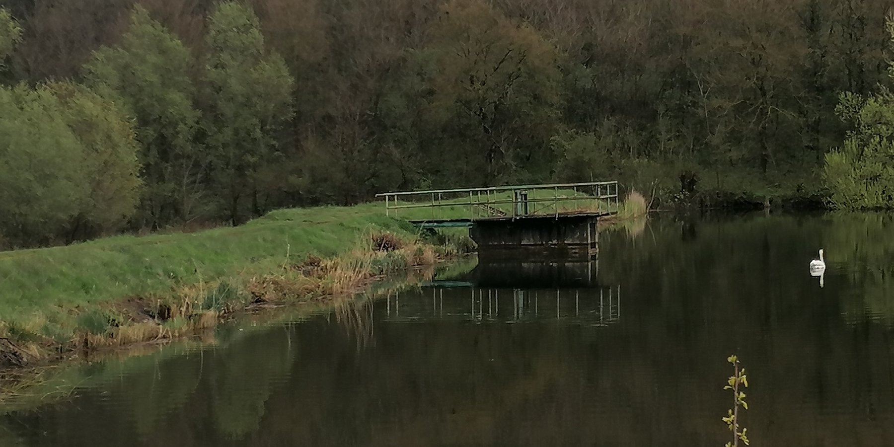
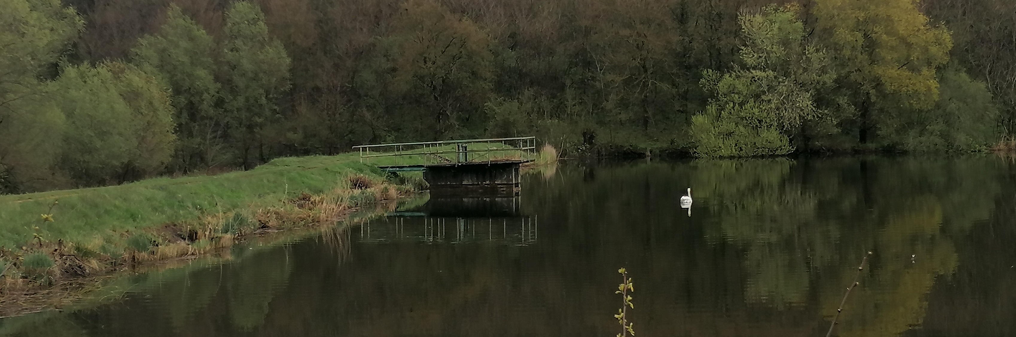
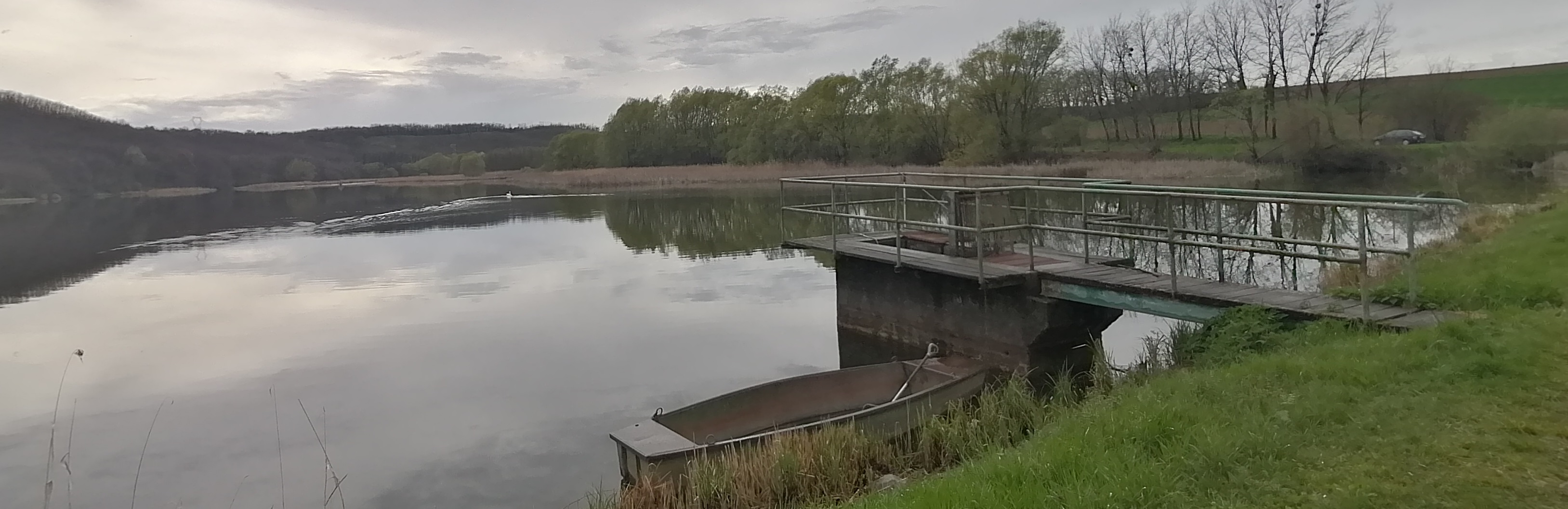
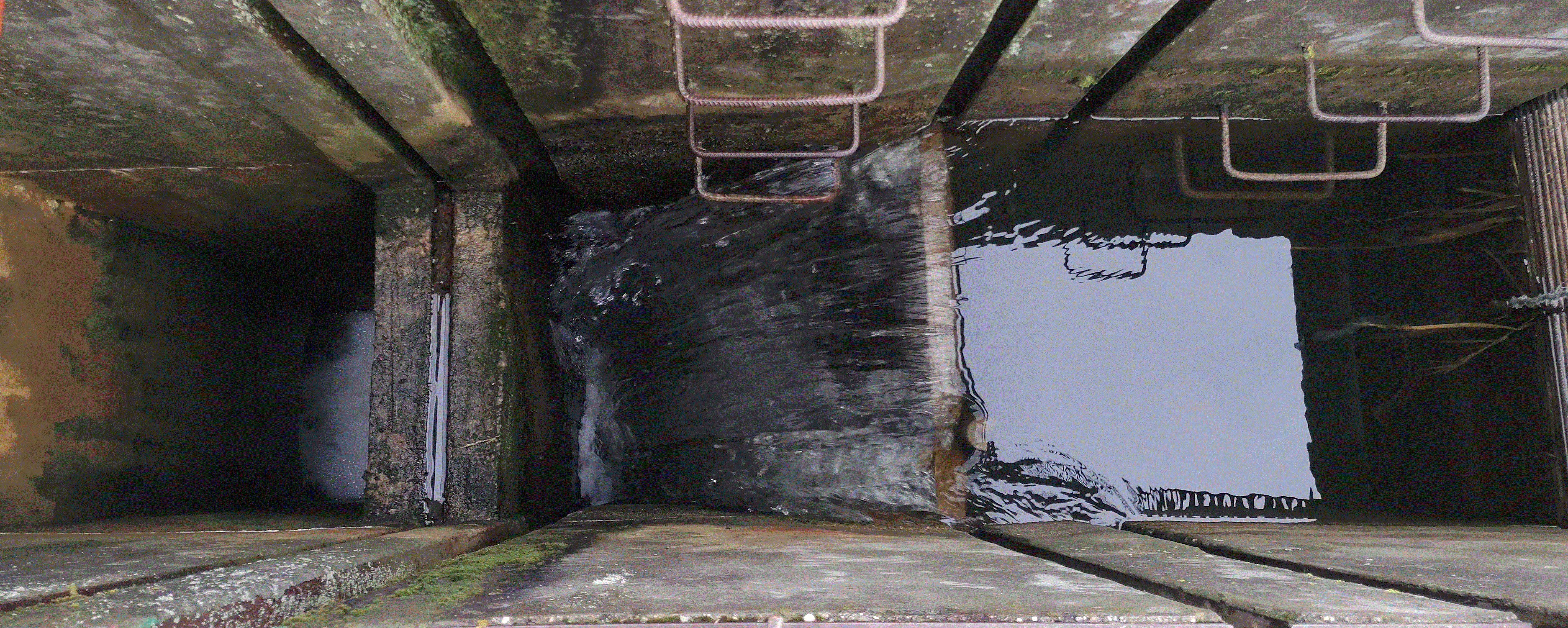
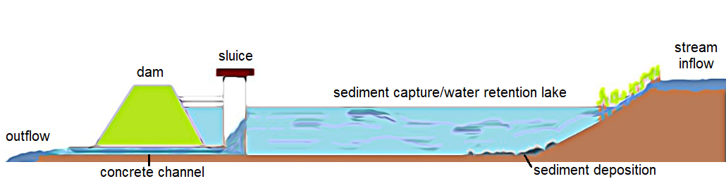
Sediment capture ponds are constructed and located along networks of ditches which drain watersheds. They slow the velocity of water and cause the deposition of suspended materials. These ponds help to avoid sediment accumulation in the ditches themselves, and can decrease sediment and nutrient pollution of surface water bodies downstream.
2.2 Detailed description of the Technology
Description:
Sediment capture ponds are designed to be able to retain runoff water during rainy periods. They are located along networks of ditches which drain watersheds – and are constructed through mechanical excavation. The technology is usually applied in hilly areas, but sometimes downstream ponds are located in or near urban zones. The ponds slow the velocity of water and cause deposition of suspended materials. They help to avoid sediment accumulation in the ditches themselves, and can decrease sediment and nutrient pollution of surface water bodies downstream. Water retention in the upstream area results in better infiltration and provides a source of water for wildlife. As sediment is regularly deposited in the ponds, they need to be desilted to maintain effectiveness.
2.3 Photos of the Technology
Media Gallery
2.4 Videos of the Technology
Comments, short description:
video is not available
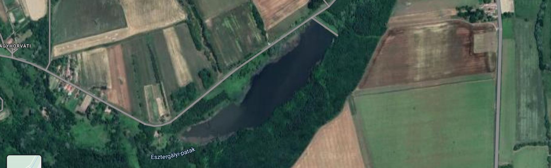
2.5 Country/ region/ locations where the Technology has been applied and which are covered by this assessment
Country:
Hungary
Region/ State/ Province:
Zala County
Further specification of location:
Esztergályhorváti
Specify the spread of the Technology:
- applied at specific points/ concentrated on a small area
Is/are the technology site(s) located in a permanently protected area?
No
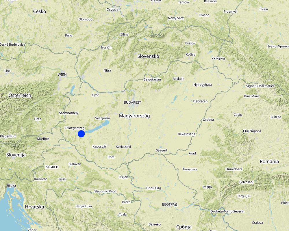
Map
×2.6 Date of implementation
If precise year is not known, indicate approximate date:
- 10-50 years ago
2.7 Introduction of the Technology
Specify how the Technology was introduced:
- through projects/ external interventions
Comments (type of project, etc.):
A project supported the management of the catchment area to improve municipal security and recreation.
3. Classification of the SLM Technology
3.1 Main purpose(s) of the Technology
- reduce, prevent, restore land degradation
- protect a watershed/ downstream areas – in combination with other Technologies
- reduce risk of disasters
- mitigate climate change and its impacts
- create beneficial social impact
3.2 Current land use type(s) where the Technology is applied
Land use mixed within the same land unit:
No

Cropland
- Annual cropping
Annual cropping - Specify crops:
- cereals - barley
- cereals - maize
- cereals - wheat (winter)
- oilseed crops - sunflower, rapeseed, other
Number of growing seasons per year:
- 1
Is intercropping practiced?
Yes
If yes, specify which crops are intercropped:
cover crops are grown between cash crops
Is crop rotation practiced?
Yes
If yes, specify:
oilseed rape - winter wheat - maize - spring barley
3.3 Has land use changed due to the implementation of the Technology?
Has land use changed due to the implementation of the Technology?
- No (Continue with question 3.4)
Land use mixed within the same land unit:
No
3.4 Water supply
Water supply for the land on which the Technology is applied:
- rainfed
3.5 SLM group to which the Technology belongs
- water harvesting
- surface water management (spring, river, lakes, sea)
- wetland protection/ management
3.6 SLM measures comprising the Technology

structural measures
- S5: Dams, pans, ponds
3.7 Main types of land degradation addressed by the Technology

water degradation
- Hp: decline of surface water quality
3.8 Prevention, reduction, or restoration of land degradation
Specify the goal of the Technology with regard to land degradation:
- prevent land degradation
- adapt to land degradation
4. Technical specifications, implementation activities, inputs, and costs
4.1 Technical drawing of the Technology
Technical specifications (related to technical drawing):
Larger sedimentation ponds can be several square kilometers in size, while others are only a few tens or hundreds of square meters. Generally, the size of sedimentation ponds depends on the characteristics of the surrounding area, the amount and frequency of rainfall, and the sources of water supply to the pond. The depth of a sedimentation pond can also vary depending on its purpose and location. In general, sedimentation ponds are designed to have a shallow depth, typically around 1 to 3 meters.
Author:
Piroska Kassai
Date:
17/04/2023
4.2 General information regarding the calculation of inputs and costs
Specify how costs and inputs were calculated:
- per Technology unit
Specify unit:
Pond
Specify dimensions of unit (if relevant):
108,000 m3
Specify currency used for cost calculations:
- USD
Indicate average wage cost of hired labour per day:
50
4.3 Establishment activities
| Activity | Timing (season) | |
|---|---|---|
| 1. | excavation of pond | not relevant |
| 2. | building dam | |
| 3. | building flood gate | |
| 4. | excavation of ditch system |
4.4 Costs and inputs needed for establishment
| Specify input | Unit | Quantity | Costs per Unit | Total costs per input | % of costs borne by land users | |
|---|---|---|---|---|---|---|
| Other | building the wole system by contractor | whole pond and belongings | 1.0 | 1420000.0 | 1420000.0 | |
| Total costs for establishment of the Technology | 1420000.0 | |||||
| Total costs for establishment of the Technology in USD | 1420000.0 | |||||
If you are unable to break down the costs in the table above, give an estimation of the total costs of establishing the Technology:
1420000.0
If land user bore less than 100% of costs, indicate who covered the remaining costs:
costs were covered by public and municipal funds
4.5 Maintenance/ recurrent activities
| Activity | Timing/ frequency | |
|---|---|---|
| 1. | periodic excavation of deposited sediments | not relevant |
4.6 Costs and inputs needed for maintenance/ recurrent activities (per year)
| Specify input | Unit | Quantity | Costs per Unit | Total costs per input | % of costs borne by land users | |
|---|---|---|---|---|---|---|
| Other | periodic excavation of deposited sediments is carried out by contractor | whole work | 1.0 | 40000.0 | 40000.0 | |
| Total costs for maintenance of the Technology | 40000.0 | |||||
| Total costs for maintenance of the Technology in USD | 40000.0 | |||||
If you are unable to break down the costs in the table above, give an estimation of the total costs of maintaining the Technology:
40000.0
4.7 Most important factors affecting the costs
Describe the most determinate factors affecting the costs:
amount of sediments, topographical conditions
5. Natural and human environment
5.1 Climate
Annual rainfall
- < 250 mm
- 251-500 mm
- 501-750 mm
- 751-1,000 mm
- 1,001-1,500 mm
- 1,501-2,000 mm
- 2,001-3,000 mm
- 3,001-4,000 mm
- > 4,000 mm
Specify average annual rainfall (if known), in mm:
653.00
Specifications/ comments on rainfall:
distribution is uneven
Indicate the name of the reference meteorological station considered:
Keszthely meteorological station
Agro-climatic zone
- sub-humid
distribution of rainfall is uneven, heat waves often occur during summertime
5.2 Topography
Slopes on average:
- flat (0-2%)
- gentle (3-5%)
- moderate (6-10%)
- rolling (11-15%)
- hilly (16-30%)
- steep (31-60%)
- very steep (>60%)
Landforms:
- plateau/plains
- ridges
- mountain slopes
- hill slopes
- footslopes
- valley floors
Altitudinal zone:
- 0-100 m a.s.l.
- 101-500 m a.s.l.
- 501-1,000 m a.s.l.
- 1,001-1,500 m a.s.l.
- 1,501-2,000 m a.s.l.
- 2,001-2,500 m a.s.l.
- 2,501-3,000 m a.s.l.
- 3,001-4,000 m a.s.l.
- > 4,000 m a.s.l.
Indicate if the Technology is specifically applied in:
- concave situations
Comments and further specifications on topography:
landscape is hilly and different land use patterns (arable land, ward and forest) are mixed in the area
5.3 Soils
Soil depth on average:
- very shallow (0-20 cm)
- shallow (21-50 cm)
- moderately deep (51-80 cm)
- deep (81-120 cm)
- very deep (> 120 cm)
Soil texture (topsoil):
- fine/ heavy (clay)
Soil texture (> 20 cm below surface):
- fine/ heavy (clay)
Topsoil organic matter:
- medium (1-3%)
If available, attach full soil description or specify the available information, e.g. soil type, soil PH/ acidity, Cation Exchange Capacity, nitrogen, salinity etc.
Soil type is Luvisol
5.4 Water availability and quality
Ground water table:
5-50 m
Availability of surface water:
good
Water quality (untreated):
good drinking water
Water quality refers to:
ground water
Is water salinity a problem?
No
Is flooding of the area occurring?
No
Comments and further specifications on water quality and quantity:
source of pollution is agriculture (manure, fertilisers, pesticides)
5.5 Biodiversity
Species diversity:
- medium
Habitat diversity:
- high
5.6 Characteristics of land users applying the Technology
Sedentary or nomadic:
- Sedentary
Market orientation of production system:
- commercial/ market
Off-farm income:
- less than 10% of all income
Relative level of wealth:
- average
Individuals or groups:
- individual/ household
- groups/ community
Level of mechanization:
- mechanized/ motorized
Gender:
- women
- men
Age of land users:
- middle-aged
- elderly
Indicate other relevant characteristics of the land users:
The pond was built by communal and local water authority collaboration.
5.7 Average area of land used by land users applying the Technology
- < 0.5 ha
- 0.5-1 ha
- 1-2 ha
- 2-5 ha
- 5-15 ha
- 15-50 ha
- 50-100 ha
- 100-500 ha
- 500-1,000 ha
- 1,000-10,000 ha
- > 10,000 ha
Is this considered small-, medium- or large-scale (referring to local context)?
- medium-scale
- large-scale
Comments:
large cooperatives and small farms are mixed in the area
5.8 Land ownership, land use rights, and water use rights
Land ownership:
- individual, not titled
- individual, titled
Land use rights:
- leased
- individual
Water use rights:
- communal (organized)
Are land use rights based on a traditional legal system?
Yes
5.9 Access to services and infrastructure
health:
- poor
- moderate
- good
education:
- poor
- moderate
- good
technical assistance:
- poor
- moderate
- good
employment (e.g. off-farm):
- poor
- moderate
- good
markets:
- poor
- moderate
- good
energy:
- poor
- moderate
- good
roads and transport:
- poor
- moderate
- good
drinking water and sanitation:
- poor
- moderate
- good
financial services:
- poor
- moderate
- good
6. Impacts and concluding statements
6.1 On-site impacts the Technology has shown
Socio-economic impacts
Water availability and quality
irrigation water availability
Comments/ specify:
Water of sediment capture/retention ponds can be used for irrigation purposes, depending on the quality of the water and the intended use of the irrigation.
Socio-cultural impacts
recreational opportunities
Comments/ specify:
Some retention ponds allow for some recreational activities too such as fishing, bird-watching, or walking trails around the pond.
Ecological impacts
Water cycle/ runoff
water quality
Comments/ specify:
The water flowing out of the stormwater retention pond may be clearer than the water flowing into it because the sedimentation process in the pond removes suspended solids from the water.
harvesting/ collection of water
Comments/ specify:
Water retention ponds are an effective way to collect and manage stormwater runoff.
surface runoff
Comments/ specify:
Water retention ponds can help to reduce surface runoff during periods of heavy rainfall or snowmelt, which can help to mitigate the risk of flooding and erosion.
Soil
soil loss
Comments/ specify:
By reducing the volume and peak flow rate of stormwater runoff, retention ponds can help to reduce the velocity and erosive power of water
Biodiversity: vegetation, animals
animal diversity
Comments/ specify:
Water retention ponds can have both positive and negative effects on biodiversity. Besides fish and waterfowl, mosquitoes may also proliferate, which can be disturbing for nearby settlements.
habitat diversity
Climate and disaster risk reduction
flood impacts
Comments/ specify:
Stormwater retention ponds are the most effective solutions to prevent floods and their impacts
landslides/ debris flows
micro-climate
Comments/ specify:
Ponds can increase humidity levels and the presence of vegetation around the water body can also have a cooling effect
6.2 Off-site impacts the Technology has shown
downstream flooding
downstream siltation
Comments/ specify:
Lakes are capable of capturing large amounts of sediment.
groundwater/ river pollution
Comments/ specify:
The stream water flowing out of lakes is generally much cleaner and less polluted due to the settling of suspended sediment.
buffering/ filtering capacity
Comments/ specify:
Stormwater retention ponds and other similar water bodies can act as natural filters.
damage on public/ private infrastructure
Comments/ specify:
By providing a place for the excess water to go, these ponds reduce the amount of water that flows onto streets and buildings, which can help prevent flash flooding and water damage.
6.3 Exposure and sensitivity of the Technology to gradual climate change and climate-related extremes/ disasters (as perceived by land users)
Gradual climate change
Gradual climate change
| Season | increase or decrease | How does the Technology cope with it? | |
|---|---|---|---|
| annual temperature | increase | well | |
| annual rainfall | decrease | very well |
Climate-related extremes (disasters)
Hydrological disasters
| How does the Technology cope with it? | |
|---|---|
| general (river) flood | well |
| flash flood | moderately |
6.4 Cost-benefit analysis
How do the benefits compare with the establishment costs (from land users’ perspective)?
Short-term returns:
positive
Long-term returns:
positive
How do the benefits compare with the maintenance/ recurrent costs (from land users' perspective)?
Short-term returns:
neutral/ balanced
Long-term returns:
positive
Comments:
These ponds are not generally constructed by land users, but by municipalities using grants/subsidies. Therefore, it is a very cost-effective solution from land users perspective in both the short and long term.
6.5 Adoption of the Technology
- single cases/ experimental
Of all those who have adopted the Technology, how many did so spontaneously, i.e. without receiving any material incentives/ payments?
- 0-10%
Comments:
zero
6.6 Adaptation
Has the Technology been modified recently to adapt to changing conditions?
No
6.7 Strengths/ advantages/ opportunities of the Technology
| Strengths/ advantages/ opportunities in the land user’s view |
|---|
| water reservoir for irrigation |
| Strengths/ advantages/ opportunities in the compiler’s or other key resource person’s view |
|---|
| possible fish pond management |
| recreation |
| increasing habitat and bio diversity |
6.8 Weaknesses/ disadvantages/ risks of the Technology and ways of overcoming them
| Weaknesses/ disadvantages/ risks in the land user’s view | How can they be overcome? |
|---|---|
| habitats for mosquitoes |
7. References and links
7.1 Methods/ sources of information
- field visits, field surveys
5
- interviews with land users
5
When were the data compiled (in the field)?
15/10/2022
7.2 References to available publications
Title, author, year, ISBN:
Ponds - Planning, Design, Construction (Agriculture Handbook 590), USDA, ISBN 9781365086069
Available from where? Costs?
enbook.hu, 25 USD
7.3 Links to relevant online information
Title/ description:
European NWRM Platform
URL:
http://nwrm.eu/measures-catalogue
7.4 General comments
Questionnaire is very detailed
Links and modules
Expand all Collapse allLinks
Farmer own initiated water harvesting pond in the … [Bangladesh]
This is an indigenous approach to store rain water for irrigating rice and other crops in the hillside earthen dam.
- Compiler: Tuku Talukder
Modules
No modules