Mechanical benches (Wafa SAIDI)

Mechanical Benches (Tunisia)

المصاطب الميكانيكية

Description

Mechanical bench terraces are a landscaping technique employed on sloping terrain. These are essentially mechanically constructed earthen levees or embankments established along contour lines.

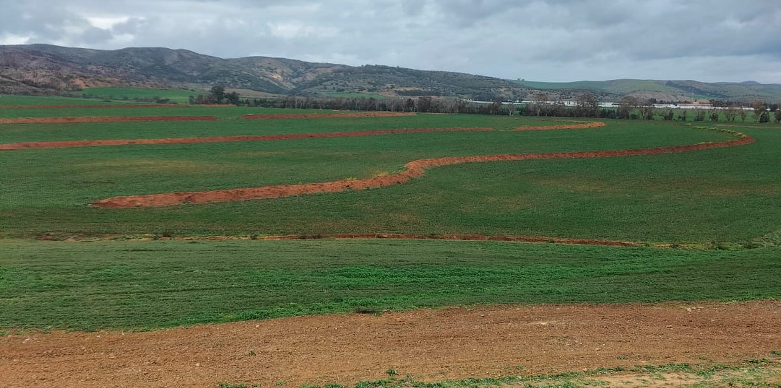
Mechanical bench terraces are anti-erosion structures that consist of embankment bunds accompanied by drainage channels. They are suitable for areas with high average annual rainfall and low rainfall intensity. The ideal conditions for their implementation include light to medium-textured soil rich in humus, a minimum top layer depth of 1.5 m, and a gentle slope ranging from 4 to 6%.
Designed as cascading structures that break the length of the slope, these terraces provide several advantages, including improvements in water quality and reduced downstream sedimentation. Properly constructed, this practice facilitates water infiltration into the soil, enhances soil fertility, and contributes to slowing erosion in small watersheds, while also aiding in surface water storage on farms. These embankments are designed to:
- prevent erosion on cereal-growing lands
- create a micro-climate favourable to arboriculture
- orient land cultivation along contour lines
- facilitate crop rotation
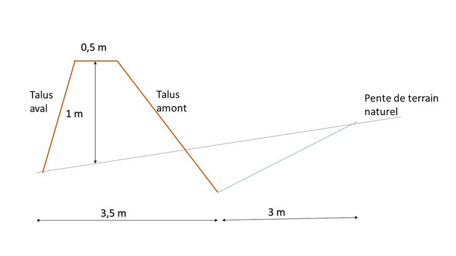
The technical specifications, including inter-embankment spacing, height, and width, vary based on site-specific conditions and conservation objectives. The installation and maintenance of mechanical total retention embankments requires several key activities and inputs, including:
- site analysis and planning to determine appropriate design and construction specifications
- heavy machinery and equipment for construction
- appropriate construction materials
- ongoing maintenance, including erosion and sedimentation monitoring, as well as periodic maintenance to repair or replace damaged terraces
Land users may hold differing opinions on total retention embankments, as they present both advantages and potential disadvantages. Some users appreciate the positive impacts on water quality and erosion reduction, while others are concerned about potential disruptions to land-use activities and the reduction in utilized agricultural area.

Location

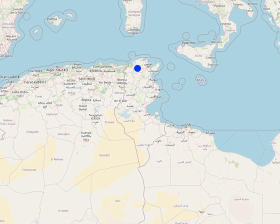
Location: Mjez El Bab, Béja, Tunisia

No. of Technology sites analysed: single site

Geo-reference of selected sites
  • 9.37799, 36.68886

Spread of the Technology: evenly spread over an area (approx. > 10,000 km2)

In a permanently protected area?: No

Date of implementation: 10-50 years ago

Type of introduction
A site featuring mechanical embankments (Wafa SAIDI)

Classification of the Technology

Main purpose
  • improve production
  • reduce, prevent, restore land degradation
  • conserve ecosystem
  • protect a watershed/ downstream areas – in combination with other Technologies
  • preserve/ improve biodiversity
  • reduce risk of disasters
  • adapt to climate change/ extremes and its impacts
  • mitigate climate change and its impacts
  • create beneficial economic impact
  • create beneficial social impact
Land use
Land use mixed within the same land unit: No

  • Cropland
    • Annual cropping: fodder crops - other. Cropping system: Wheat or similar rotation with hay/pasture
    Number of growing seasons per year: 1
    Is intercropping practiced? Yes
Water supply
  • rainfed
  • mixed rainfed-irrigated
  • full irrigation

Purpose related to land degradation
  • prevent land degradation
  • reduce land degradation
  • restore/ rehabilitate severely degraded land
  • adapt to land degradation
  • not applicable
Degradation addressed
  • soil erosion by water - Wt: loss of topsoil/ surface erosion
  • chemical soil deterioration - Cn: fertility decline and reduced organic matter content (not caused by erosion)
SLM group
  • improved ground/ vegetation cover
  • cross-slope measure
  • water harvesting
  • Intercropping
SLM measures
  • structural measures - S1: Terraces
  • management measures - M2: Change of management/ intensity level

Technical drawing

Technical specifications
- Natural slope: 4 to 6%.
- Crest width: 0.5 m
- Bund height: 1 m
- Width of base of embankment: 3.5 m
- Channel width: 3 m
Author: Wafa Saidi

Establishment and maintenance: activities, inputs and costs

Calculation of inputs and costs
  • Costs are calculated: per Technology area (size and area unit: ha)
  • Currency used for cost calculation: Tunisian dinars
  • Exchange rate (to USD): 1 USD = 3.1 Tunisian dinars
  • Average wage cost of hired labour per day: 20
Most important factors affecting the costs
The cost of installing mechanical embankments is contingent on the site's condition. If the site is rocky or the soil is hard, construction may prove more challenging and time-consuming. Additionally, the size of a embankment bench influences the overall cost, as larger embankments require more materials, labor, and equipment. Labour costs depend on the location and the availability of workers.
Establishment activities
  1. Site selection: The first step is to select a suitable site for the mechanical embankments. The site must be located on a slope with sufficient rainfall for the embankment to be effective in terms of water conservation. (Timing/ frequency: None)
  2. Study and design: The next step is to study the site and design the mechanical embankments. The design of the embankment should consider the topography of the site, as well as factors such as soil type and the rainfall pattern in the area. These embankments should be engineered with the purpose of retaining all the water and soil that flows into them. (Timing/ frequency: None)
  3. Site preparation: Once the design has been completed, the site must be prepared for the construction of the mechanical benches. This may involve removing vegetation, levelling the site and preparing the foundations. (Timing/ frequency: None)
  4. Construction of the embankment: The mechanical embankment is built using a combination of earthmoving equipment and manual labor. (Timing/ frequency: None)
  5. Installation of water diversion structures: Water diversion structures are installed to ensure the retention of all water flowing over the embankment. These structures can include check dams, infiltration trenches and swales. (Timing/ frequency: None)
  6. Completion of the ridge of the embankment by means of a trax (Timing/ frequency: None)
  7. Subsoiling or ploughing (Timing/ frequency: None)
Total establishment costs (estimation)
2500.0
Maintenance activities
  1. Repair damage caused by erosion (Timing/ frequency: None)
Total maintenance costs (estimation)
375.0

Natural environment

Average annual rainfall
  • < 250 mm
  • 251-500 mm
  • 501-750 mm
  • 751-1,000 mm
  • 1,001-1,500 mm
  • 1,501-2,000 mm
  • 2,001-3,000 mm
  • 3,001-4,000 mm
  • > 4,000 mm
Agro-climatic zone
  • humid
  • sub-humid
  • semi-arid
  • arid
Specifications on climate
The region exhibits highly irregular rainfall patterns from one year to the next, with several consecutive dry years, adding an element of uncertainty to the harvesting of field crops. February, October, and November experience the highest levels of rainfall in the region.
Name of the meteorological station: Mjez El Beb CTV
The governorate of Béja has an average annual temperature of approximately 18°C. Summers are characterized by hot weather, with average temperatures generally exceeding 25°C. High temperatures typically range between 27 and 32°C. Winters are relatively mild, with average temperatures ranging from 10 to 12°C. Low temperatures during winter average between 5 and 7°C.
Slope
  • flat (0-2%)
  • gentle (3-5%)
  • moderate (6-10%)
  • rolling (11-15%)
  • hilly (16-30%)
  • steep (31-60%)
  • very steep (>60%)
Landforms
  • plateau/plains
  • ridges
  • mountain slopes
  • hill slopes
  • footslopes
  • valley floors
Altitude
  • 0-100 m a.s.l.
  • 101-500 m a.s.l.
  • 501-1,000 m a.s.l.
  • 1,001-1,500 m a.s.l.
  • 1,501-2,000 m a.s.l.
  • 2,001-2,500 m a.s.l.
  • 2,501-3,000 m a.s.l.
  • 3,001-4,000 m a.s.l.
  • > 4,000 m a.s.l.
Technology is applied in
  • convex situations
  • concave situations
  • not relevant
Soil depth
  • very shallow (0-20 cm)
  • shallow (21-50 cm)
  • moderately deep (51-80 cm)
  • deep (81-120 cm)
  • very deep (> 120 cm)
Soil texture (topsoil)
  • coarse/ light (sandy)
  • medium (loamy, silty)
  • fine/ heavy (clay)
Soil texture (> 20 cm below surface)
  • coarse/ light (sandy)
  • medium (loamy, silty)
  • fine/ heavy (clay)
Topsoil organic matter content
  • high (>3%)
  • medium (1-3%)
  • low (<1%)
Groundwater table
  • on surface
  • < 5 m
  • 5-50 m
  • > 50 m
Availability of surface water
  • excess
  • good
  • medium
  • poor/ none
Water quality (untreated)
  • good drinking water
  • poor drinking water (treatment required)
  • for agricultural use only (irrigation)
  • unusable
Water quality refers to: both ground and surface water
Is salinity a problem?
  • Yes
  • No

Occurrence of flooding
  • Yes
  • No
Species diversity
  • high
  • medium
  • low
Habitat diversity
  • high
  • medium
  • low

Characteristics of land users applying the Technology

Market orientation
  • subsistence (self-supply)
  • mixed (subsistence/ commercial)
  • commercial/ market
Off-farm income
  • less than 10% of all income
  • 10-50% of all income
  • > 50% of all income
Relative level of wealth
  • very poor
  • poor
  • average
  • rich
  • very rich
Level of mechanization
  • manual work
  • animal traction
  • mechanized/ motorized
Sedentary or nomadic
  • Sedentary
  • Semi-nomadic
  • Nomadic
Individuals or groups
  • individual/ household
  • groups/ community
  • cooperative
  • employee (company, government)
Gender
  • women
  • men
Age
  • children
  • youth
  • middle-aged
  • elderly
Area used per household
  • < 0.5 ha
  • 0.5-1 ha
  • 1-2 ha
  • 2-5 ha
  • 5-15 ha
  • 15-50 ha
  • 50-100 ha
  • 100-500 ha
  • 500-1,000 ha
  • 1,000-10,000 ha
  • > 10,000 ha
Scale
  • small-scale
  • medium-scale
  • large-scale
Land ownership
  • state
  • company
  • communal/ village
  • group
  • individual, not titled
  • individual, titled
Land use rights
  • open access (unorganized)
  • communal (organized)
  • leased
  • individual
Water use rights
  • open access (unorganized)
  • communal (organized)
  • leased
  • individual
Access to services and infrastructure
health

poor
x
good
education

poor
x
good
technical assistance

poor
x
good
employment (e.g. off-farm)

poor
x
good
markets

poor
x
good
energy

poor
x
good
roads and transport

poor
x
good
drinking water and sanitation

poor
x
good
financial services

poor
x
good

Impacts

Socio-economic impacts
Crop production
decreased
x
increased


A 40% increase in dry-year cereal yields

crop quality
decreased
x
increased

risk of production failure
increased
x
decreased

product diversity
decreased
x
increased

production area (new land under cultivation/ use)
decreased
x
increased

farm income
decreased
x
increased

Quantity before SLM: 0%
Quantity after SLM: 50%

workload
increased
x
decreased


Cultivating soil on land equipped with mechanical embankments necessitates following the contour lines, imposing a heavier workload.

Socio-cultural impacts
food security/ self-sufficiency
reduced
x
improved

Ecological impacts
harvesting/ collection of water (runoff, dew, snow, etc)
reduced
x
improved

Quantity before SLM: 0%
Quantity after SLM: 25%

surface runoff
increased
x
decreased

soil moisture
decreased
x
increased


The design of the full-retention mechanical embankment helps capture and retain water, ensuring enhanced moisture availability.

soil loss
increased
x
decreased

Quantity before SLM: 80%
Quantity after SLM: 20%

soil accumulation
decreased
x
increased

nutrient cycling/ recharge
decreased
x
increased

soil organic matter/ below ground C
decreased
x
increased

vegetation cover
decreased
x
increased

plant diversity
decreased
x
increased


The landscaping of the land with mechanical embankments facilitates intercropping.

flood impacts
increased
x
decreased


Embankments are obstacles that slow down the velocity of runoff water.

drought impacts
increased
x
decreased


The design features of mechanical retention embankments help mitigate the effects of heat and drought.

impacts of cyclones, rain storms
increased
x
decreased

micro-climate
worsened
x
improved

Off-site impacts
downstream siltation
increased
x
decreased

Cost-benefit analysis

Benefits compared with establishment costs
Short-term returns
very negative
x
very positive

Long-term returns
very negative
x
very positive

Benefits compared with maintenance costs
Short-term returns
very negative
x
very positive

Long-term returns
very negative
x
very positive

Climate change

Gradual climate change
seasonal rainfall decrease

not well at all
x
very well
Season: wet/ rainy season
Climate-related extremes (disasters)
local rainstorm

not well at all
x
very well

Adoption and adaptation

Percentage of land users in the area who have adopted the Technology
  • single cases/ experimental
  • 1-10%
  • 11-50%
  • > 50%
Of all those who have adopted the Technology, how many have done so without receiving material incentives?
  • 0-10%
  • 11-50%
  • 51-90%
  • 91-100%
Has the Technology been modified recently to adapt to changing conditions?
  • Yes
  • No
To which changing conditions?
  • climatic change/ extremes
  • changing markets
  • labour availability (e.g. due to migration)

Conclusions and lessons learnt

Strengths: land user's view
  • This technology ensures optimum soil moisture retention.
  • The embankments slow the flow of water, allowing it to infiltrate into the soil rather than causing runoff. This helps prevent soil erosion, preserves topsoil and promotes soil health and stability.
  • Embankments create microclimates suitable for vegetation growth.
Strengths: compiler’s or other key resource person’s view
  • Mechanical embankment technology adheres to the principles of sustainable land management, emphasizing the preservation of ecosystems, erosion mitigation, and responsible utilization of natural resources
  • Mechanical embankments help land users adapt to the challenges posed by climate change. Through the conservation of water, soil erosion control, and facilitation of vegetation growth, these embankments enable land users to mitigate the impacts of shifting climatic conditions, fostering the development of more resilient and sustainable landscapes.
Weaknesses/ disadvantages/ risks: land user's viewhow to overcome
  • Reduced arable land Diversify crops
  • Workload
Weaknesses/ disadvantages/ risks: compiler’s or other key resource person’s viewhow to overcome
  • Technical complexity Ongoing education
  • Maintenance and repairs Biological consolidation of embankments with cactus, acacia, olive trees, etc.

References

Compiler
  • Wafa Saidi
Editors
  • Siagbé Golli
  • Faouzi Harrouchi
  • faouzi BATTI
  • Fatma Maaloul
  • Tabitha Nekesa
  • Ahmadou Gaye
Reviewer
  • William Critchley
  • Rima Mekdaschi Studer
Date of documentation: Feb. 20, 2023
Last update: April 23, 2024
Resource persons
Full description in the WOCAT database
Linked SLM data
Documentation was faciliated by
Institution Project
Key references
  • Guide de conservation des eaux et du Sol, Ministère de l’agriculture, Direction Générale de l'Aménagement et de la Conservations des Terres Agricoles, 1995: Ministère de l’agriculture, Direction Générale de l'Aménagement et de la Conservations des Terres Agricoles: Directorate-General for the Development and Conservation of Agricultural Lands, 1995: Ministry of Agriculture, Directorate-General for the Development and Conservation of Agricultural Lands.
  • Carte agricole de la Tunisie, Ministère de l’agriculture, 2005: Ministry of Agriculture, Directorate-General for the Development and Conservation of Agricultural Lands
Links to relevant information which is available online
This work is licensed under Creative Commons Attribution-NonCommercial-ShareaAlike 4.0 International