Mechanical Benches [Tunisia]
- Creation:
- Update:
- Compiler: Wafa Saidi
- Editors: Siagbé Golli, Faouzi Harrouchi, faouzi BATTI, Fatma Maaloul, Tabitha Nekesa, Ahmadou Gaye
- Reviewers: William Critchley, Rima Mekdaschi Studer
المصاطب الميكانيكية
technologies_6655 - Tunisia
View sections
Expand all Collapse all1. General information
1.2 Contact details of resource persons and institutions involved in the assessment and documentation of the Technology
Key resource person(s)
SLM specialist:
Brahmi Mongi
Arrondissement Conservation des Eaux et des Sols, Commissariats Régionaux au Développement Agricole Béja
Tunisia
Name of project which facilitated the documentation/ evaluation of the Technology (if relevant)
Soil protection and rehabilitation for food security (ProSo(i)l)Name of the institution(s) which facilitated the documentation/ evaluation of the Technology (if relevant)
Direction Générale de l’Amenagement et de Conservation des Terres Agricoles (DG/ACTA) - TunisiaName of the institution(s) which facilitated the documentation/ evaluation of the Technology (if relevant)
GIZ Tunisia (GIZ Tunisia) - Tunisia1.3 Conditions regarding the use of data documented through WOCAT
The compiler and key resource person(s) accept the conditions regarding the use of data documented through WOCAT:
Yes
1.4 Declaration on sustainability of the described Technology
Is the Technology described here problematic with regard to land degradation, so that it cannot be declared a sustainable land management technology?
No
1.5 Reference to Questionnaire(s) on SLM Approaches (documented using WOCAT)
Territorial Natural Resource Management Observatory [Tunisia]
A territorial natural resources management observatory is a scientific, technical and institutional system set up in a given area to observe, monitor and improve knowledge.
- Compiler: Wafa Saidi
Integrated Territorial Planning and Development Project (PADIT) [Tunisia]
The PADIT approach comprises a cross-cutting participatory methodology to rural development, rallying various stakeholders around a project, within a location, to identify the main economic areas of the rural community concerned, and draw up a prioritized list of actions to strengthen and support development efforts in their location.
- Compiler: Wafa Saidi
2. Description of the SLM Technology
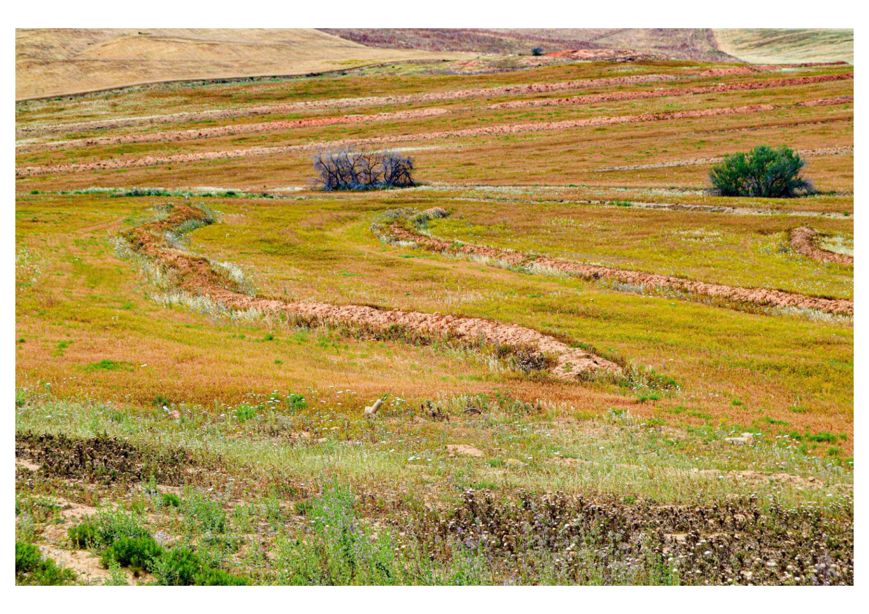
2.1 Short description of the Technology
Definition of the Technology:
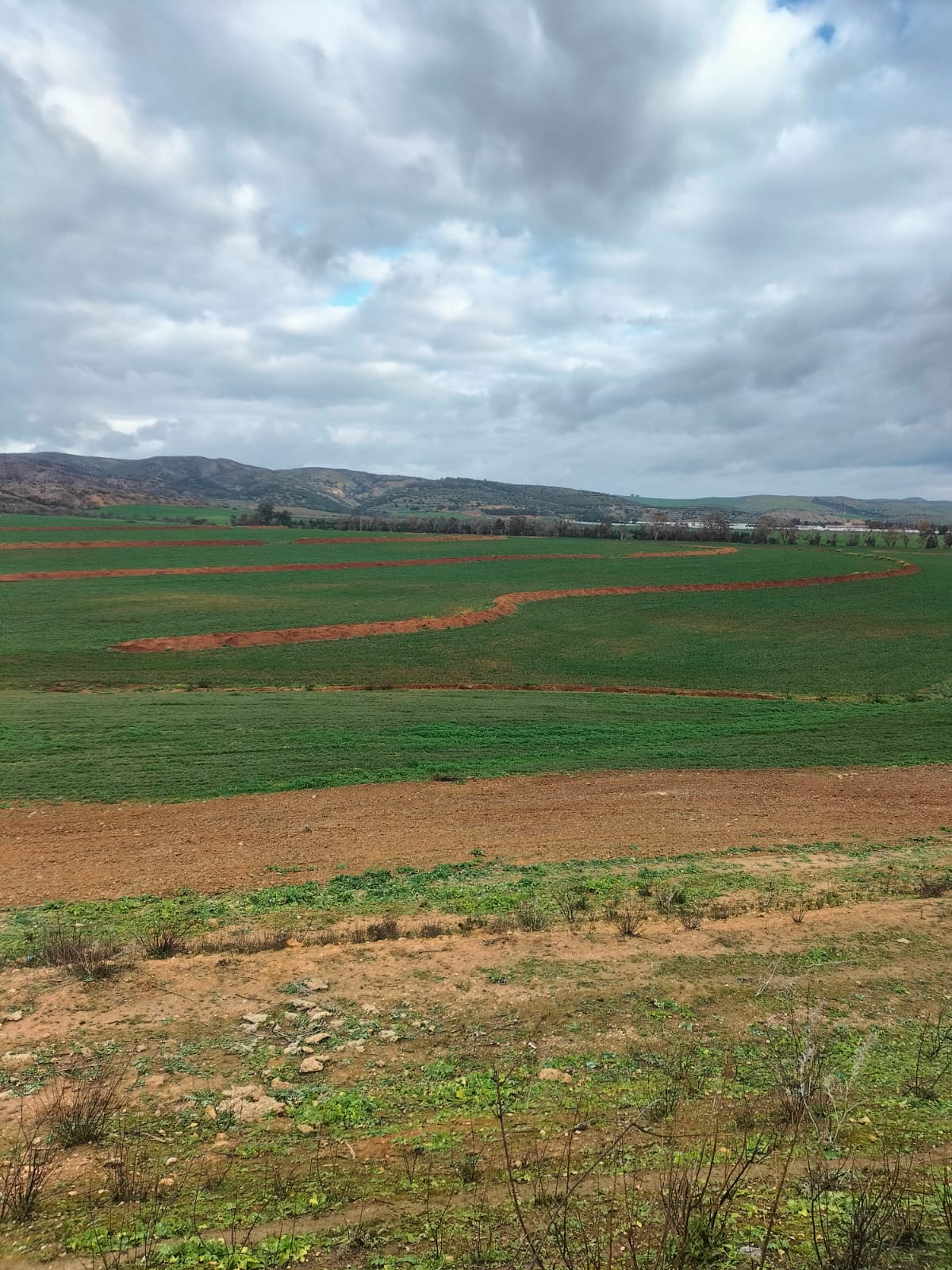
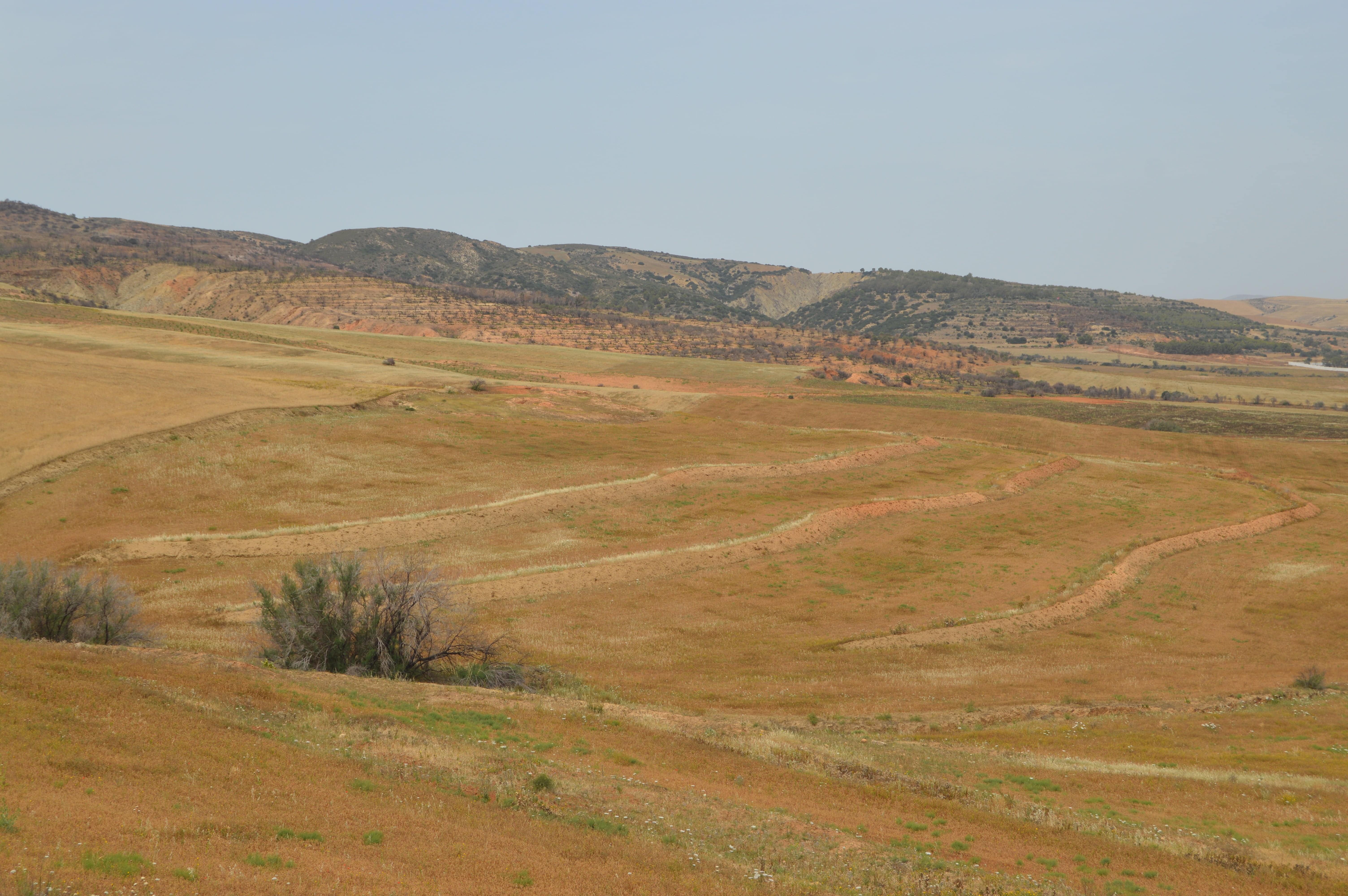
Mechanical bench terraces are a landscaping technique employed on sloping terrain. These are essentially mechanically constructed earthen levees or embankments established along contour lines.
2.2 Detailed description of the Technology
Description:
Mechanical bench terraces are anti-erosion structures that consist of embankment bunds accompanied by drainage channels. They are suitable for areas with high average annual rainfall and low rainfall intensity. The ideal conditions for their implementation include light to medium-textured soil rich in humus, a minimum top layer depth of 1.5 m, and a gentle slope ranging from 4 to 6%.
Designed as cascading structures that break the length of the slope, these terraces provide several advantages, including improvements in water quality and reduced downstream sedimentation. Properly constructed, this practice facilitates water infiltration into the soil, enhances soil fertility, and contributes to slowing erosion in small watersheds, while also aiding in surface water storage on farms. These embankments are designed to:
- prevent erosion on cereal-growing lands
- create a micro-climate favourable to arboriculture
- orient land cultivation along contour lines
- facilitate crop rotation
The technical specifications, including inter-embankment spacing, height, and width, vary based on site-specific conditions and conservation objectives. The installation and maintenance of mechanical total retention embankments requires several key activities and inputs, including:
- site analysis and planning to determine appropriate design and construction specifications
- heavy machinery and equipment for construction
- appropriate construction materials
- ongoing maintenance, including erosion and sedimentation monitoring, as well as periodic maintenance to repair or replace damaged terraces
Land users may hold differing opinions on total retention embankments, as they present both advantages and potential disadvantages. Some users appreciate the positive impacts on water quality and erosion reduction, while others are concerned about potential disruptions to land-use activities and the reduction in utilized agricultural area.
2.3 Photos of the Technology
Media Gallery
2.5 Country/ region/ locations where the Technology has been applied and which are covered by this assessment
Country:
Tunisia
Region/ State/ Province:
Béja
Further specification of location:
Mjez El Bab
Specify the spread of the Technology:
- evenly spread over an area
If precise area is not known, indicate approximate area covered:
- > 10,000 km2
Is/are the technology site(s) located in a permanently protected area?
No
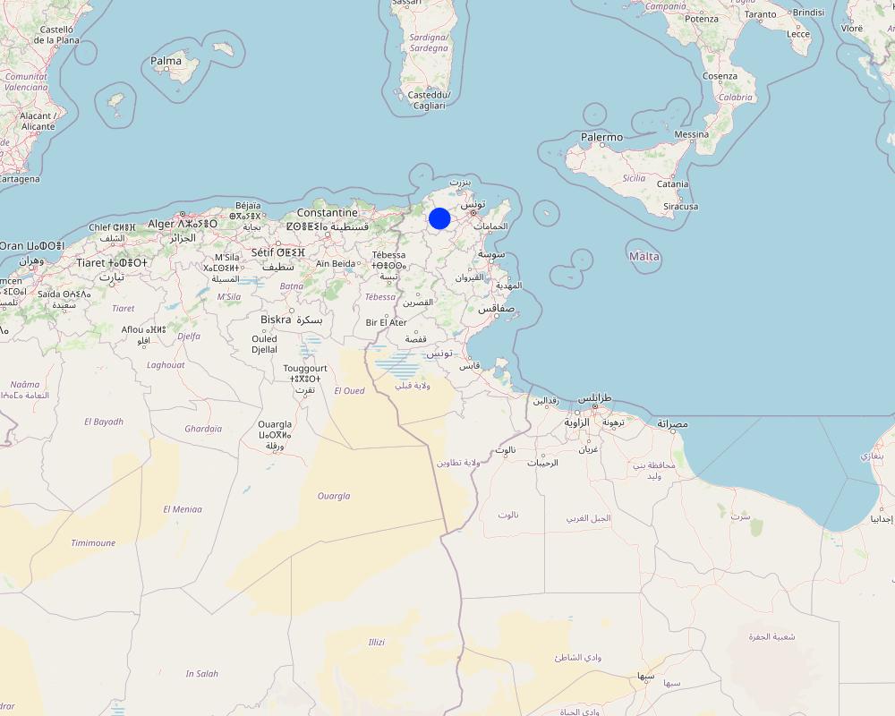
Map
×2.6 Date of implementation
If precise year is not known, indicate approximate date:
- 10-50 years ago
2.7 Introduction of the Technology
Specify how the Technology was introduced:
- through projects/ external interventions
Comments (type of project, etc.):
The CES strategy planned for the 1990-2001 decade.
3. Classification of the SLM Technology
3.1 Main purpose(s) of the Technology
- improve production
- reduce, prevent, restore land degradation
- protect a watershed/ downstream areas – in combination with other Technologies
- create beneficial economic impact
3.2 Current land use type(s) where the Technology is applied
Land use mixed within the same land unit:
No

Cropland
- Annual cropping
Annual cropping - Specify crops:
- fodder crops - other
Annual cropping system:
Wheat or similar rotation with hay/pasture
Number of growing seasons per year:
- 1
Is intercropping practiced?
Yes
If yes, specify which crops are intercropped:
Fenugreek, Vetch
3.3 Has land use changed due to the implementation of the Technology?
Has land use changed due to the implementation of the Technology?
- No (Continue with question 3.4)
3.4 Water supply
Water supply for the land on which the Technology is applied:
- rainfed
3.5 SLM group to which the Technology belongs
- improved ground/ vegetation cover
- cross-slope measure
- water harvesting
- Intercropping
3.6 SLM measures comprising the Technology

structural measures
- S1: Terraces

management measures
- M2: Change of management/ intensity level
3.7 Main types of land degradation addressed by the Technology

soil erosion by water
- Wt: loss of topsoil/ surface erosion

chemical soil deterioration
- Cn: fertility decline and reduced organic matter content (not caused by erosion)
3.8 Prevention, reduction, or restoration of land degradation
Specify the goal of the Technology with regard to land degradation:
- reduce land degradation
- restore/ rehabilitate severely degraded land
4. Technical specifications, implementation activities, inputs, and costs
4.1 Technical drawing of the Technology
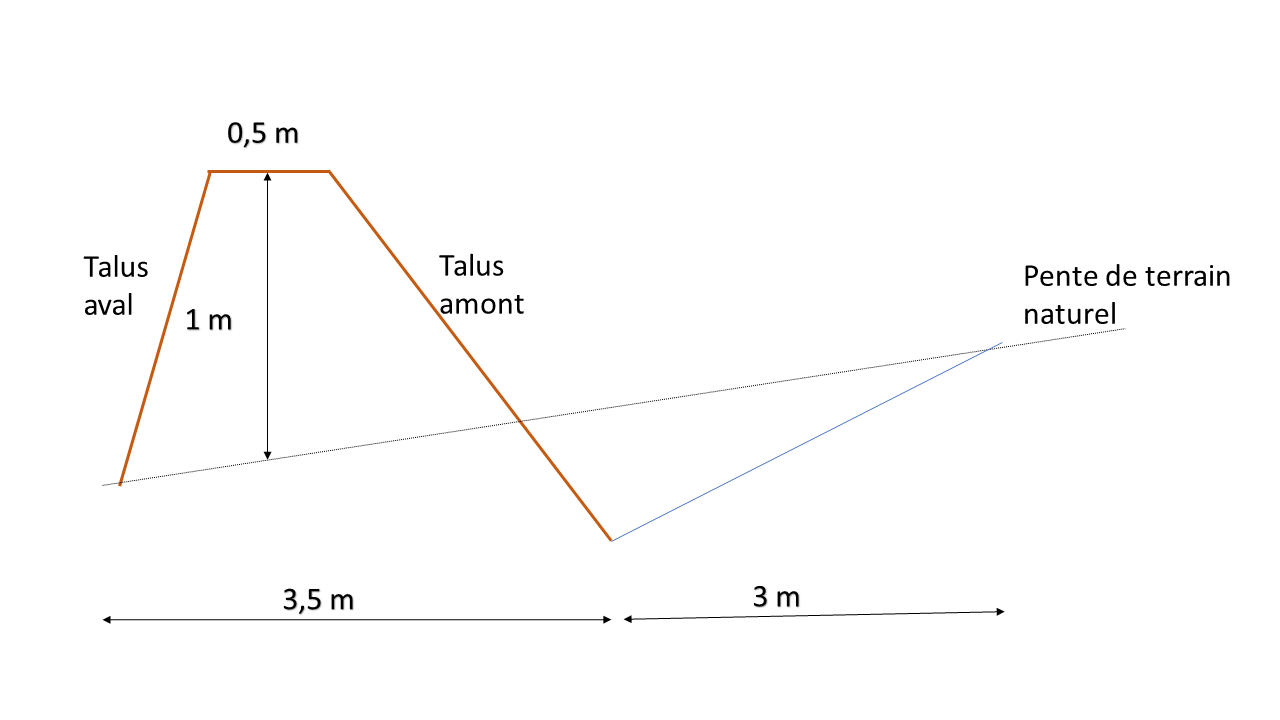
Technical specifications (related to technical drawing):
- Natural slope: 4 to 6%.
- Crest width: 0.5 m
- Bund height: 1 m
- Width of base of embankment: 3.5 m
- Channel width: 3 m
Author:
Wafa Saidi
Date:
03/2023
4.2 General information regarding the calculation of inputs and costs
Specify how costs and inputs were calculated:
- per Technology area
Indicate size and area unit:
ha
other/ national currency (specify):
Tunisian dinars
If relevant, indicate exchange rate from USD to local currency (e.g. 1 USD = 79.9 Brazilian Real): 1 USD =:
3.1
Indicate average wage cost of hired labour per day:
20
4.3 Establishment activities
| Activity | Timing (season) | |
|---|---|---|
| 1. | Site selection: The first step is to select a suitable site for the mechanical embankments. The site must be located on a slope with sufficient rainfall for the embankment to be effective in terms of water conservation. | |
| 2. | Study and design: The next step is to study the site and design the mechanical embankments. The design of the embankment should consider the topography of the site, as well as factors such as soil type and the rainfall pattern in the area. These embankments should be engineered with the purpose of retaining all the water and soil that flows into them. | |
| 3. | Site preparation: Once the design has been completed, the site must be prepared for the construction of the mechanical benches. This may involve removing vegetation, levelling the site and preparing the foundations. | |
| 4. | Construction of the embankment: The mechanical embankment is built using a combination of earthmoving equipment and manual labor. | |
| 5. | Installation of water diversion structures: Water diversion structures are installed to ensure the retention of all water flowing over the embankment. These structures can include check dams, infiltration trenches and swales. | |
| 6. | Completion of the ridge of the embankment by means of a trax | |
| 7. | Subsoiling or ploughing |
4.4 Costs and inputs needed for establishment
If you are unable to break down the costs in the table above, give an estimation of the total costs of establishing the Technology:
2500.0
If land user bore less than 100% of costs, indicate who covered the remaining costs:
Directorate-General for the Development and Conservation of Agricultural Lands
4.5 Maintenance/ recurrent activities
| Activity | Timing/ frequency | |
|---|---|---|
| 1. | Repair damage caused by erosion |
4.6 Costs and inputs needed for maintenance/ recurrent activities (per year)
If you are unable to break down the costs in the table above, give an estimation of the total costs of maintaining the Technology:
375.0
If land user bore less than 100% of costs, indicate who covered the remaining costs:
Directorate-General for the Development and Conservation of Agricultural Lands (DGACTA)
4.7 Most important factors affecting the costs
Describe the most determinate factors affecting the costs:
The cost of installing mechanical embankments is contingent on the site's condition. If the site is rocky or the soil is hard, construction may prove more challenging and time-consuming. Additionally, the size of a embankment bench influences the overall cost, as larger embankments require more materials, labor, and equipment.
Labour costs depend on the location and the availability of workers.
5. Natural and human environment
5.1 Climate
Annual rainfall
- < 250 mm
- 251-500 mm
- 501-750 mm
- 751-1,000 mm
- 1,001-1,500 mm
- 1,501-2,000 mm
- 2,001-3,000 mm
- 3,001-4,000 mm
- > 4,000 mm
Specifications/ comments on rainfall:
The region exhibits highly irregular rainfall patterns from one year to the next, with several consecutive dry years, adding an element of uncertainty to the harvesting of field crops. February, October, and November experience the highest levels of rainfall in the region.
Indicate the name of the reference meteorological station considered:
Mjez El Beb CTV
Agro-climatic zone
- semi-arid
The governorate of Béja has an average annual temperature of approximately 18°C. Summers are characterized by hot weather, with average temperatures generally exceeding 25°C. High temperatures typically range between 27 and 32°C. Winters are relatively mild, with average temperatures ranging from 10 to 12°C. Low temperatures during winter average between 5 and 7°C.
5.2 Topography
Slopes on average:
- flat (0-2%)
- gentle (3-5%)
- moderate (6-10%)
- rolling (11-15%)
- hilly (16-30%)
- steep (31-60%)
- very steep (>60%)
Landforms:
- plateau/plains
- ridges
- mountain slopes
- hill slopes
- footslopes
- valley floors
Altitudinal zone:
- 0-100 m a.s.l.
- 101-500 m a.s.l.
- 501-1,000 m a.s.l.
- 1,001-1,500 m a.s.l.
- 1,501-2,000 m a.s.l.
- 2,001-2,500 m a.s.l.
- 2,501-3,000 m a.s.l.
- 3,001-4,000 m a.s.l.
- > 4,000 m a.s.l.
Indicate if the Technology is specifically applied in:
- not relevant
5.3 Soils
Soil depth on average:
- very shallow (0-20 cm)
- shallow (21-50 cm)
- moderately deep (51-80 cm)
- deep (81-120 cm)
- very deep (> 120 cm)
Soil texture (topsoil):
- medium (loamy, silty)
- fine/ heavy (clay)
Soil texture (> 20 cm below surface):
- medium (loamy, silty)
- fine/ heavy (clay)
Topsoil organic matter:
- medium (1-3%)
If available, attach full soil description or specify the available information, e.g. soil type, soil PH/ acidity, Cation Exchange Capacity, nitrogen, salinity etc.
Topsoil texture: medium fine
Reference soil depth (cm): 100
Organic carbon in topsoil (wt.%): 0.65
Topsoil pH (H2O): 6.9
Topsoil calcium carbonate (wt.%): 0.4
Topsoil gypsum (wt.%): 0.2
Topsoil sodicity (ESP) (%): 2
Topsoil salinity (ECe) (dS/m): 2.7
Subsoil texture: clayey silt (light) clayey silty clay (light)
Subsoil organic carbon (wt%): 0.27
Subsoil pH (H2O): 7.3
Subsoil calcium carbonate (weight %): 1.7
Subsoil gypsum (weight %): 0.5
Subsoil sodicity (ESP) (%): 2
Subsoil salinity (ECe) (dS/m): 1.7
5.4 Water availability and quality
Ground water table:
> 50 m
Availability of surface water:
good
Water quality (untreated):
poor drinking water (treatment required)
Water quality refers to:
both ground and surface water
Is water salinity a problem?
No
Is flooding of the area occurring?
Yes
Regularity:
episodically
5.5 Biodiversity
Species diversity:
- medium
Habitat diversity:
- medium
5.6 Characteristics of land users applying the Technology
Sedentary or nomadic:
- Sedentary
Market orientation of production system:
- commercial/ market
Off-farm income:
- 10-50% of all income
Relative level of wealth:
- rich
Individuals or groups:
- individual/ household
Level of mechanization:
- mechanized/ motorized
Gender:
- men
Age of land users:
- youth
5.7 Average area of land used by land users applying the Technology
- < 0.5 ha
- 0.5-1 ha
- 1-2 ha
- 2-5 ha
- 5-15 ha
- 15-50 ha
- 50-100 ha
- 100-500 ha
- 500-1,000 ha
- 1,000-10,000 ha
- > 10,000 ha
Is this considered small-, medium- or large-scale (referring to local context)?
- large-scale
5.8 Land ownership, land use rights, and water use rights
Land ownership:
- individual, titled
Land use rights:
- individual
Water use rights:
- individual
Are land use rights based on a traditional legal system?
No
5.9 Access to services and infrastructure
health:
- poor
- moderate
- good
education:
- poor
- moderate
- good
technical assistance:
- poor
- moderate
- good
employment (e.g. off-farm):
- poor
- moderate
- good
markets:
- poor
- moderate
- good
energy:
- poor
- moderate
- good
roads and transport:
- poor
- moderate
- good
drinking water and sanitation:
- poor
- moderate
- good
financial services:
- poor
- moderate
- good
6. Impacts and concluding statements
6.1 On-site impacts the Technology has shown
Socio-economic impacts
Production
crop production
Comments/ specify:
A 40% increase in dry-year cereal yields
crop quality
risk of production failure
product diversity
production area
Income and costs
farm income
Quantity before SLM:
0%
Quantity after SLM:
50%
workload
Comments/ specify:
Cultivating soil on land equipped with mechanical embankments necessitates following the contour lines, imposing a heavier workload.
Socio-cultural impacts
food security/ self-sufficiency
Ecological impacts
Water cycle/ runoff
harvesting/ collection of water
Quantity before SLM:
0%
Quantity after SLM:
25%
surface runoff
Soil
soil moisture
Comments/ specify:
The design of the full-retention mechanical embankment helps capture and retain water, ensuring enhanced moisture availability.
soil loss
Quantity before SLM:
80%
Quantity after SLM:
20%
soil accumulation
nutrient cycling/ recharge
soil organic matter/ below ground C
Biodiversity: vegetation, animals
Vegetation cover
plant diversity
Comments/ specify:
The landscaping of the land with mechanical embankments facilitates intercropping.
Climate and disaster risk reduction
flood impacts
Comments/ specify:
Embankments are obstacles that slow down the velocity of runoff water.
drought impacts
Comments/ specify:
The design features of mechanical retention embankments help mitigate the effects of heat and drought.
impacts of cyclones, rain storms
micro-climate
Specify assessment of on-site impacts (measurements):
On-site impact assessment is based on observations of land users and the results of research projects.
6.2 Off-site impacts the Technology has shown
downstream siltation
Specify assessment of off-site impacts (measurements):
The assessment of external impacts is based on experts' estimates.
6.3 Exposure and sensitivity of the Technology to gradual climate change and climate-related extremes/ disasters (as perceived by land users)
Gradual climate change
Gradual climate change
| Season | increase or decrease | How does the Technology cope with it? | |
|---|---|---|---|
| seasonal rainfall | wet/ rainy season | decrease | very well |
Climate-related extremes (disasters)
Meteorological disasters
| How does the Technology cope with it? | |
|---|---|
| local rainstorm | very well |
6.4 Cost-benefit analysis
How do the benefits compare with the establishment costs (from land users’ perspective)?
Short-term returns:
very positive
Long-term returns:
very positive
How do the benefits compare with the maintenance/ recurrent costs (from land users' perspective)?
Short-term returns:
very positive
Long-term returns:
very positive
6.5 Adoption of the Technology
- > 50%
Of all those who have adopted the Technology, how many did so spontaneously, i.e. without receiving any material incentives/ payments?
- 11-50%
6.6 Adaptation
Has the Technology been modified recently to adapt to changing conditions?
No
6.7 Strengths/ advantages/ opportunities of the Technology
| Strengths/ advantages/ opportunities in the land user’s view |
|---|
| This technology ensures optimum soil moisture retention. |
| The embankments slow the flow of water, allowing it to infiltrate into the soil rather than causing runoff. This helps prevent soil erosion, preserves topsoil and promotes soil health and stability. |
| Embankments create microclimates suitable for vegetation growth. |
| Strengths/ advantages/ opportunities in the compiler’s or other key resource person’s view |
|---|
| Mechanical embankment technology adheres to the principles of sustainable land management, emphasizing the preservation of ecosystems, erosion mitigation, and responsible utilization of natural resources |
| Mechanical embankments help land users adapt to the challenges posed by climate change. Through the conservation of water, soil erosion control, and facilitation of vegetation growth, these embankments enable land users to mitigate the impacts of shifting climatic conditions, fostering the development of more resilient and sustainable landscapes. |
6.8 Weaknesses/ disadvantages/ risks of the Technology and ways of overcoming them
| Weaknesses/ disadvantages/ risks in the land user’s view | How can they be overcome? |
|---|---|
| Reduced arable land | Diversify crops |
| Workload |
| Weaknesses/ disadvantages/ risks in the compiler’s or other key resource person’s view | How can they be overcome? |
|---|---|
| Technical complexity | Ongoing education |
| Maintenance and repairs | Biological consolidation of embankments with cactus, acacia, olive trees, etc. |
7. References and links
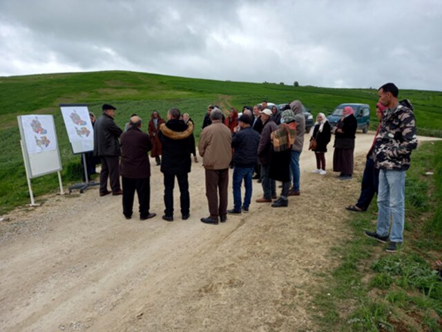
7.1 Methods/ sources of information
- field visits, field surveys
A field survey was conducted.
- interviews with land users
A farmer was interviewed.
- interviews with SLM specialists/ experts
- compilation from reports and other existing documentation
When were the data compiled (in the field)?
04/02/2023
7.2 References to available publications
Title, author, year, ISBN:
Guide de conservation des eaux et du Sol, Ministère de l’agriculture, Direction Générale de l'Aménagement et de la Conservations des Terres Agricoles, 1995: Ministère de l’agriculture, Direction Générale de l'Aménagement et de la Conservations des Terres Agricoles
Available from where? Costs?
Directorate-General for the Development and Conservation of Agricultural Lands, 1995: Ministry of Agriculture, Directorate-General for the Development and Conservation of Agricultural Lands.
Title, author, year, ISBN:
Carte agricole de la Tunisie, Ministère de l’agriculture, 2005
Available from where? Costs?
Ministry of Agriculture, Directorate-General for the Development and Conservation of Agricultural Lands
7.3 Links to relevant online information
Title/ description:
Influence du facteur lithologique sur l'échec des aménagements en banquettes de terre dans un petit bassin versant semi-aride tunisien, Noemen Baccari, 2021
URL:
https://www.researchgate.net/publication/349718199_Influence_du_facteur_lithologique_sur_l'echec_des_amenagements_en_banquettes_de_terre_dans_un_petit_bassin_versant_semi-aride_tunisien_Influence_of_lithological_factors_on_the_failure_of_ground_embank
Title/ description:
Evolution des techniques de conservation des eaux et des sols en Tunisie, Mohamed Boufaroua, 2004
URL:
https://beep.ird.fr/collect/bre/index/assoc/23-625-6.dir/23-625-635.pdf
Title/ description:
Les aménagements de conservation des eaux et des sols en banquettes : analyse, fonctionnement et essai de modélisation en milieu méditerranéen (El-Gouazine, Tunisie centrale), Youssef Al Ali, 2007
URL:
http://www.secheresse.info/spip.php?article24124
Title/ description:
Harmonized World Soil Database, FAO, 2009
URL:
https://www.fao.org/soils-portal/data-hub/soil-maps-and-databases/harmonized-world-soil-database-v12/en/
Links and modules
Expand all Collapse allLinks
Territorial Natural Resource Management Observatory [Tunisia]
A territorial natural resources management observatory is a scientific, technical and institutional system set up in a given area to observe, monitor and improve knowledge.
- Compiler: Wafa Saidi
Integrated Territorial Planning and Development Project (PADIT) [Tunisia]
The PADIT approach comprises a cross-cutting participatory methodology to rural development, rallying various stakeholders around a project, within a location, to identify the main economic areas of the rural community concerned, and draw up a prioritized list of actions to strengthen and support development efforts in their location.
- Compiler: Wafa Saidi
Modules
No modules