Participatory Understanding of Groundwater Dynamics: Threats and Responsive Management [India]
- Creation:
- Update:
- Compiler: Pratik Ramteke
- Editor: –
- Reviewers: Rima Mekdaschi Studer, William Critchley
CDVI 3D Model
approaches_7555 - India
View sections
Expand all Collapse all1. General information
1.2 Contact details of resource persons and institutions involved in the assessment and documentation of the Approach
land user:
Yadav Ankita
ankita.yadav@wotr.org.in
Watershed Organisation Trust (WOTR), Pune
India
land user:
Ghodake Navnath
navnath.ghodake@wotr.org.in
Watershed Organisation Trust (WOTR), Pune
India
Name of the institution(s) which facilitated the documentation/ evaluation of the Approach (if relevant)
Watershed Organisation Trust (WOTR) - India1.3 Conditions regarding the use of data documented through WOCAT
When were the data compiled (in the field)?
30/04/2021
The compiler and key resource person(s) accept the conditions regarding the use of data documented through WOCAT:
Yes
2. Description of the SLM Approach
2.1 Short description of the Approach
CoDriVE-VI is a participatory approach that integrates local knowledge with scientific data through 3D visual modelling to assess groundwater vulnerability and support sustainable, community-based groundwater management. It overlays surface and subsurface features, enabling villagers to visualize aquifer systems and develop informed water use plans.
2.2 Detailed description of the Approach
Detailed description of the Approach:
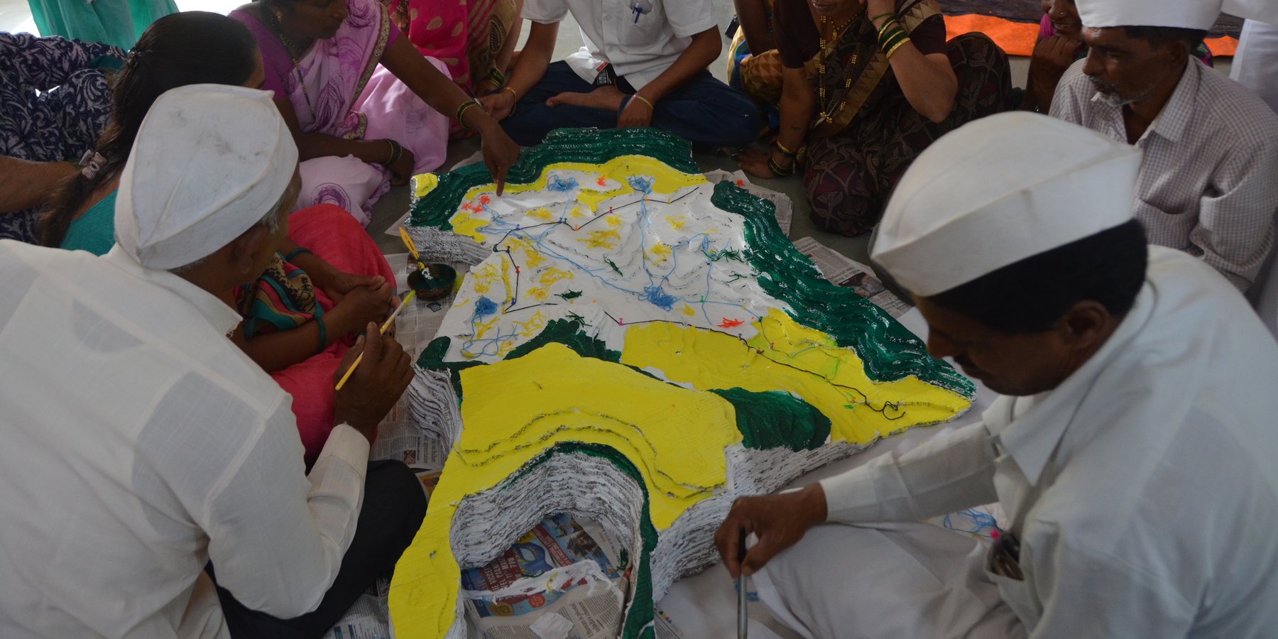
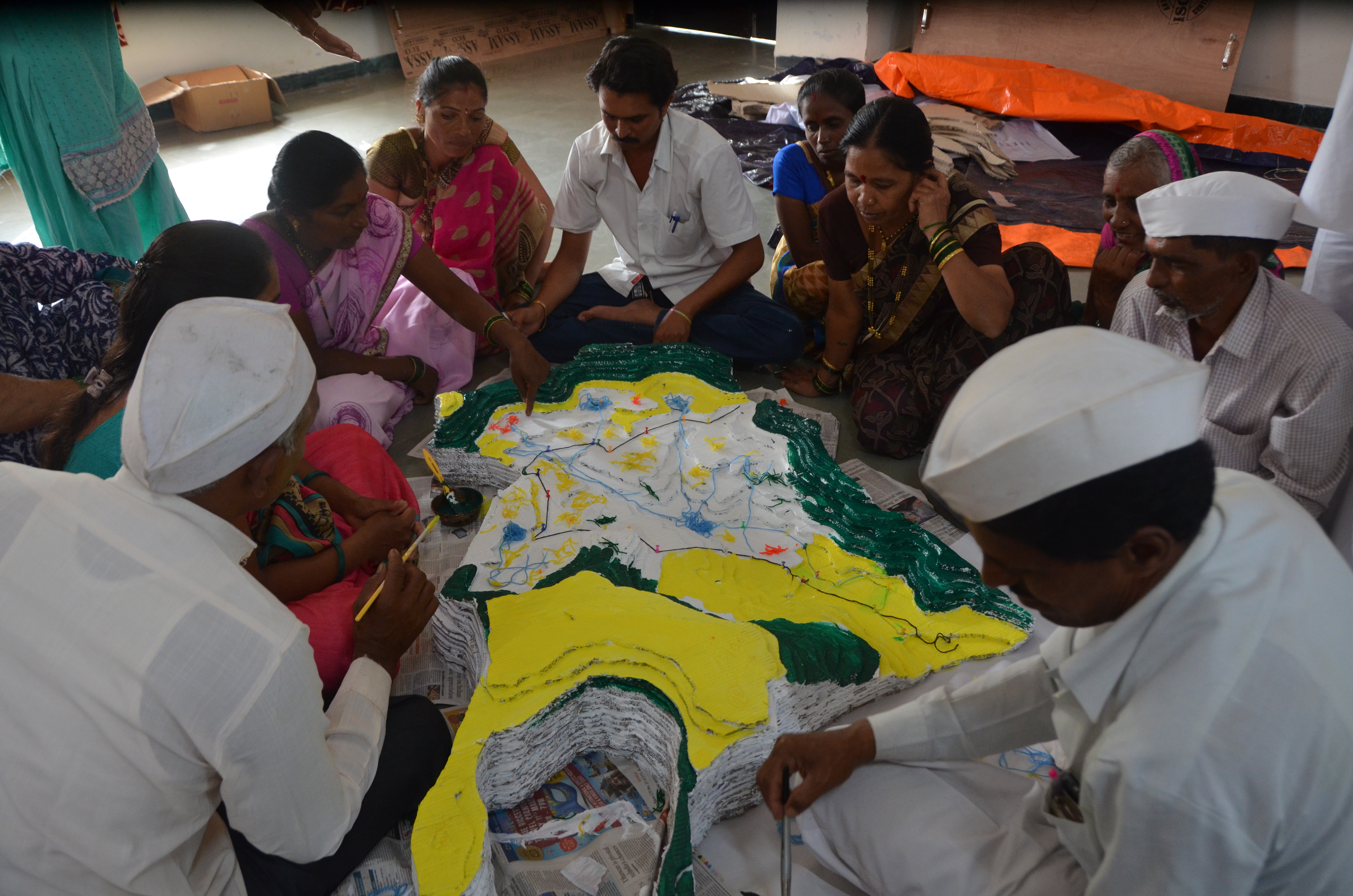
CoDriVE-VI (Community-driven Vulnerability Evaluation – Visual Integrator) is a participatory approach developed by the Watershed Organisation Trust (WOTR) to support sustainable groundwater management. It aims to demystify the invisible subsurface and make aquifer systems understandable to rural communities by combining scientific tools with local knowledge in a hands-on, visual format. While the process is facilitated by WOTR, communities are placed at the center of the process, contributing traditional insights, assisting with data collection, and actively participating in constructing and interpreting the 3D model. Thus, the approach is best described as participatory, with strong elements of community ownership and engagement.
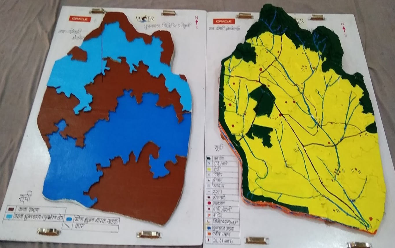
The “Visual Integrator” refers to the integration of both surface and subsurface data—such as topography, drainage, geology, well inventory details, and geophysical survey results—into a tangible, scaled three-dimensional model. This participatory 3D modelling (P3DM) process helps communities visualize how aquifers relate to the landscape, showing key features such as recharge zones, discharge points, and areas of intensive groundwater extraction.
“Vulnerability evaluation” is carried out through the community’s participatory analysis of the model. Using the integrated visual platform, villagers can identify zones that are more vulnerable to depletion—such as those with low recharge, high borewell density, or historically declining water tables. While a formal vulnerability matrix is not used, the 3D model serves as a practical vulnerability map. It guides discussions and decisions around water budgeting, aquifer recharge, crop-water planning, and the development of informal rules for responsible groundwater use.
The methodology combines participatory rural appraisal with hydrogeological and geospatial techniques. After an initial orientation and trust-building phase, communities help map surface features. Subsurface data is then collected through geological mapping, well inventory surveys, and geophysical methods like Vertical Electrical Sounding (VES). The data are analyzed using GIS tools and inverse slope modelling. The 3D model is then constructed using layered cardboard sheets, with communities contributing throughout the process—cutting, assembling, painting, and validating the layers.
The CoDriVE-VI process unfolds in several stages: community mobilization and planning; surface and subsurface data collection; model building in participatory workshops; and result interpretation and management planning. Key stakeholders include community members, WOTR facilitators, technical experts (geologists and GIS specialists), and local governance representatives.
Participants found the visual models highly effective in helping them grasp aquifer dynamics, leading to a shift in perception—from seeing groundwater as an individual entitlement to recognizing it as a shared resource. This in turn fostered collective decision-making. The approach has also contributed to improved groundwater literacy, informed water budgeting, and motivated some villages to initiate local groundwater governance practices.
While climate change is a key driver of groundwater stress, the approach also acknowledges other socio-economic and environmental pressures—such as population growth, land-use change, deforestation, and the uncontrolled proliferation of borewells—as critical factors influencing groundwater vulnerability. By visualizing these interconnections, CoDriVE-VI supports more holistic and sustainable groundwater management at the community level.
2.3 Photos of the Approach
Media Gallery
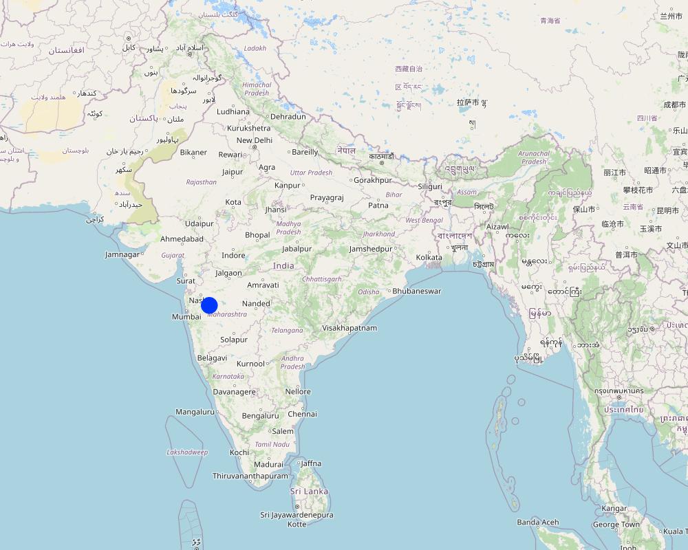
2.5 Country/ region/ locations where the Approach has been applied
Country:
India
Region/ State/ Province:
Maharashtra
Further specification of location:
Darewadi,Post. Kauthe Malkapur Tal. Sangamner, Dist. Ahilyanagar, Maharashtra
Map
×2.6 Dates of initiation and termination of the Approach
Indicate year of initiation:
2017
Comments:
The tool was developed based on experiences from multiple village-level implementations in Maharashtra. The approach is ongoing.
2.8 Main aims/ objectives of the Approach
1. To build the capacity of rural communities to understand groundwater systems, including aquifer behavior and climate and non-climate stressors affecting groundwater availability.
2. To make subsurface aquifer characteristics visible and comprehensible through participatory 3D modelling that integrates scientific and local knowledge.
3. To foster collective ownership and sustainable management of groundwater as a shared, finite resource.
4. To support community-led evaluation of groundwater vulnerability and guide responsive actions such as water budgeting and recharge planning.
5. To document, preserve, and apply indigenous spatial knowledge related to land use, topography, and local water systems.
6. To enable informed decision-making by facilitating the transfer of community-generated insights to local governance bodies and development agencies.
2.9 Conditions enabling or hindering implementation of the Technology/ Technologies applied under the Approach
social/ cultural/ religious norms and values
- enabling
The participatory nature of CoDriVE aligns well with community-based traditions and values. Villagers appreciated visual models and collective dialogue.
availability/ access to financial resources and services
- hindering
Physical model preparation and technical surveys (like geophysical VES) require resources. Financial constraints can limit replication or scaling.
institutional setting
- enabling
Support from institutions like WOTR and local governance structures helped facilitate workshops and technical assessments.
collaboration/ coordination of actors
- enabling
Strong collaboration between communities, facilitators, technical experts, and local leaders enabled smooth implementation
legal framework (land tenure, land and water use rights)
- hindering
Customary laws viewing groundwater as private property can hinder the recognition of aquifers as shared resources.
policies
- enabling
National and state-level programs like Atal Bhujal Yojana and Maharashtra Groundwater Act 2009 support aquifer-based planning and groundwater literacy.
land governance (decision-making, implementation and enforcement)
- enabling
Local institutions and village-level bodies were engaged in discussions and planning.
knowledge about SLM, access to technical support
- enabling
Technical support from WOTR and use of local knowledge supported learning and capacity building
markets (to purchase inputs, sell products) and prices
- enabling
workload, availability of manpower
- enabling
Community enthusiasm and involvement were high during workshops and model building.
- hindering
Manual preparation of 3D models requires time and coordination, which may be demanding in some villages.
other
- enabling
Visual and tactile tools helped bridge the knowledge gap between experts and villagers.
- hindering
Initial complexity of scientific terms (e.g., aquifer, resistivity) required careful facilitation and adaptation
3. Participation and roles of stakeholders involved
3.1 Stakeholders involved in the Approach and their roles
- local land users/ local communities
Villagers and farmers from Ahilyanagar and Jalna districts, Maharashtra
They participated actively in the mapping exercises, provided indigenous knowledge on topography and land use, contributed to well inventory and aquifer-related insights, and were directly involved in building the 3D models. Their engagement was central in interpreting subsurface information and applying it to groundwater planning.
- community-based organizations
Village Water Management Committees, Water Stewardship groups
Helped mobilize community members, facilitated communication between villagers and technical teams, and supported local-level planning and rule-setting for groundwater use.
- SLM specialists/ agricultural advisers
WOTR technical staff and hydrogeology facilitators
Provided scientific inputs on geology and hydrogeology, conducted well and geophysical surveys, interpreted data, supported the construction of groundwater potential maps, and trained community members in groundwater management
- researchers
Researchers and field investigators from WOTR and contributing institutions
Developed the methodology, documented experiences, synthesised scientific and community knowledge, and analysed feedback for continuous improvement of the tool.
- NGO
Watershed Organisation Trust (WOTR)
Lead agency responsible for conceptualizing, facilitating, implementing, and documenting the approach. Conducted workshops, managed technical assessments, trained field teams, and engaged communities.
- private sector
HSBC Software Development India (as supporter)
Provided financial support for printing and disseminating the CoDriVE-VI manual.
- local government
Gram Panchayat members, Sarpanches
Participated in workshops, helped validate maps and data, encouraged community participation, and supported local rule-making for sustainable groundwater use.
- national government (planners, decision-makers)
Indirectly linked via supportive policies (e.g., Atal Bhujal Yojana, National Aquifer Management Project (NAQUIM))
Although not directly involved in implementation, national policies provided support for the overall context and justification of aquifer-based participatory planning and water budgeting.
- international organization
ProSoil project (GIZ)
Supported in publishing and promoting the CoDriVE-VI manual, including showcasing it at UNCCD COP14
If several stakeholders were involved, indicate lead agency:
Watershed Organisation Trust (WOTR)
3.2 Involvement of local land users/ local communities in the different phases of the Approach
| Involvement of local land users/ local communities | Specify who was involved and describe activities | |
|---|---|---|
| initiation/ motivation | interactive | Local villagers in the project areas (e.g., Ahilyanagar and Jalna districts) were engaged early through orientation sessions. While the initiative was introduced by WOTR, community members showed interest and contributed knowledge from the beginning, especially around their water challenges and local hydrogeology. |
| planning | interactive | Villagers participated in identifying key features for surface mapping, shared traditional knowledge of aquifers and land use, and were involved in selecting locations for surveys. Their inputs shaped both the design and scale of the models. |
| implementation | interactive | Community members took part in well inventory surveys, guided geological observations, and actively built the 3D physical models. They also helped colour-code aquifer zones under facilitators’ guidance, and validated the data presented. |
| monitoring/ evaluation | interactive | During workshops and feedback sessions, villagers evaluated the accuracy of models, reflected on the implications of subsurface characteristics, and discussed how to use the insights for water budgeting and community planning |
| research | Community knowledge directly contributed to the research process by enriching scientific interpretations with local hydrogeological understanding. Their experiences and reflections were documented and used to improve the approach. |
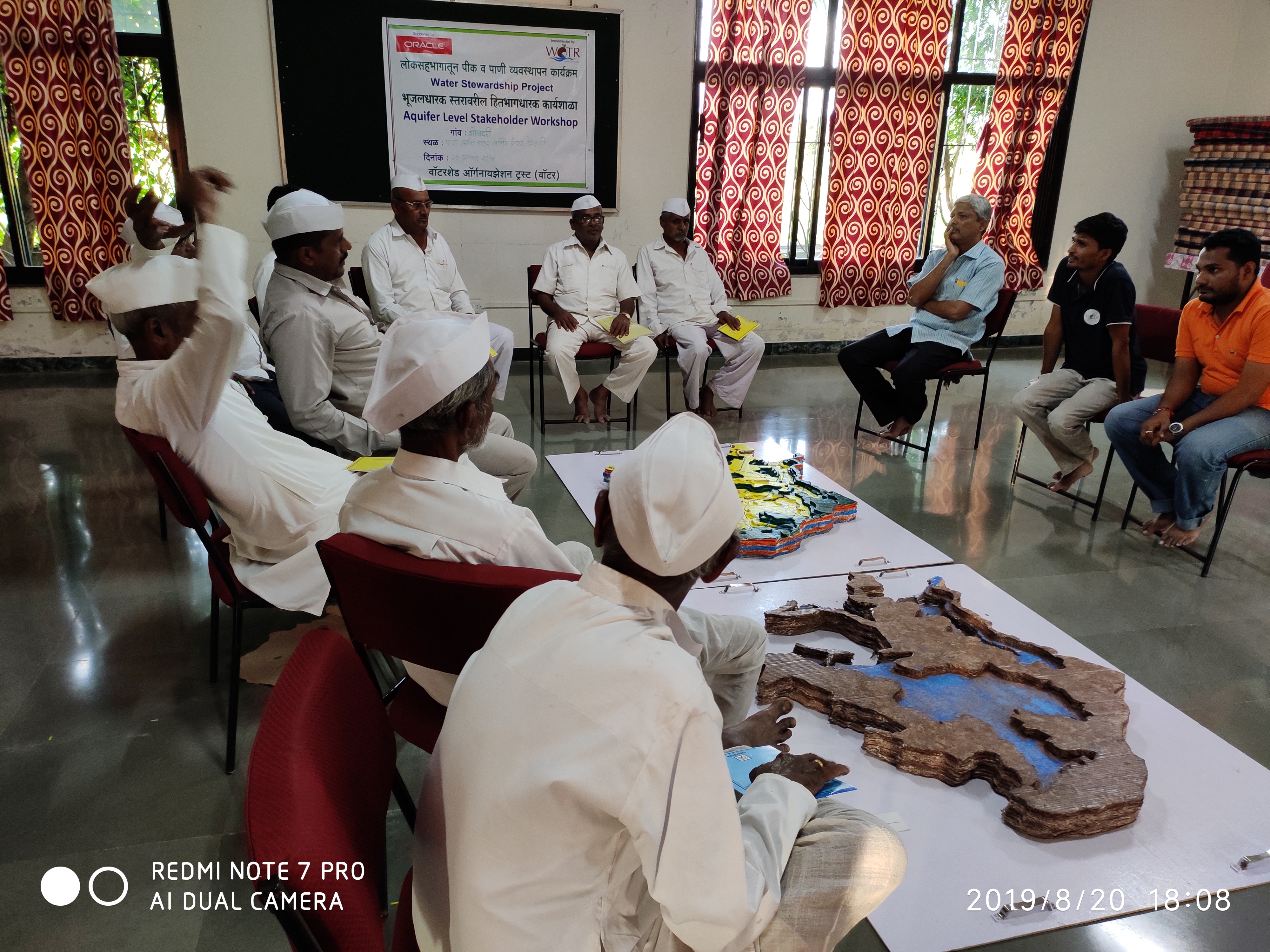
3.3 Flow chart (if available)
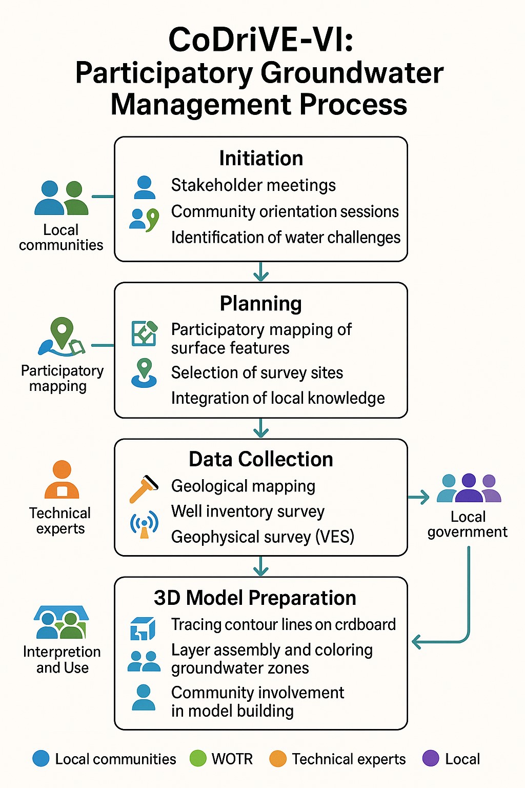
Description:
The visual summary illustrates the four key stages of the CoDriVE-VI approach
Initiation
-Stakeholder meetings and community orientation sessions are conducted.
-Local water-related challenges are identified.
-Builds a foundation for participatory engagement and problem recognition.
Planning
-Participatory mapping of surface features is carried out.
-Survey sites are selected based on local inputs and technical feasibility.
-Local knowledge is integrated with scientific planning.
Data Collection
-Technical experts conduct geological mapping and well inventory surveys.
- Geophysical surveys (e.g., Vertical Electrical Sounding - VES) are performed.
- Scientific data on groundwater systems is gathered for model development.
3D Model Preparation
-Contour lines are traced on cardboard to build physical models.
-Groundwater zones are assembled and color-coded.
-Communities are actively involved in model building and interpretation for better understanding and use.
Author:
Pratik Ramteke
3.4 Decision-making on the selection of SLM Technology/ Technologies
Specify who decided on the selection of the Technology/ Technologies to be implemented:
- all relevant actors, as part of a participatory approach
Explain:
The selection and design of the CoDriVE tool was done through participatory processes involving local communities, WOTR facilitators, and technical experts. Villagers contributed local knowledge and needs, while experts provided scientific input, ensuring collective decision-making.
Specify on what basis decisions were made:
- evaluation of well-documented SLM knowledge (evidence-based decision-making)
- research findings
- personal experience and opinions (undocumented)
- Decisions were based on field experiences from over 25 villages, scientific methods (e.g., VES surveys, GIS analysis), and documented evidence on aquifer-based planning. Local knowledge and experiential insights also guided model design and validation.
4. Technical support, capacity building, and knowledge management
4.1 Capacity building/ training
Was training provided to land users/ other stakeholders?
Yes
Specify who was trained:
- land users
- field staff/ advisers
If relevant, specify gender, age, status, ethnicity, etc.
Training involved both male and female community members, including farmers, youth, and local leaders from diverse socio-economic backgrounds in the villages. Inclusive participation was encouraged throughout
Form of training:
- on-the-job
- farmer-to-farmer
- demonstration areas
- public meetings
Subjects covered:
•Basic concepts of hydrogeology and aquifers
•Groundwater vulnerability and common pool resource concepts
•Surface and subsurface mapping
•Use of Participatory 3D Modelling (P3DM)
•Groundwater budgeting
•Climate change impacts on water resources
•Community-led planning and rule-setting for water use
4.2 Advisory service
Do land users have access to an advisory service?
Yes
Specify whether advisory service is provided:
- on land users' fields
- at permanent centres
Describe/ comments:
WOTR provided technical assistance through facilitators and hydrogeology experts. These acted as advisors, guiding communities in surveys, model interpretation, and decision-making.
4.3 Institution strengthening (organizational development)
Have institutions been established or strengthened through the Approach?
- yes, moderately
Specify the level(s) at which institutions have been strengthened or established:
- local
Describe institution, roles and responsibilities, members, etc.
Village Water User Groups (VWUGs) and local governance committees were strengthened to coordinate groundwater management activities. Their roles included planning water use, monitoring aquifer health, implementing community water rules, and facilitating knowledge sharing. Members typically included local farmers, community leaders, and field facilitators
Specify type of support:
- capacity building/ training
- equipment
Give further details:
The strengthening focused on enhancing institutional capacity to support community-driven water resource management. Training sessions improved leadership and technical skills, enabling institutions to take ownership of groundwater sustainability. Equipment such as GPS units and simple monitoring devices were provided to aid local data collection and verification.
4.4 Monitoring and evaluation
Is monitoring and evaluation part of the Approach?
Yes
Comments:
Monitoring was integrated through periodic community workshops, feedback sessions, and participatory verification of groundwater models. Evaluation focused on assessing the accuracy of aquifer mapping, effectiveness of capacity building, and impact on local water management practices.
If yes, is this documentation intended to be used for monitoring and evaluation?
Yes
Comments:
This documentation serves as a reference for tracking the implementation process, assessing community engagement, and evaluating outcomes. It can be used to guide adaptive management and inform replication in other regions.
4.5 Research
Was research part of the Approach?
Yes
Specify topics:
- sociology
- ecology
- technology
- Hydrogeology and participatory modelling
Give further details and indicate who did the research:
Research was integral to developing and refining the CoDriVE methodology. Hydrogeologists and social scientists collaborated with local communities to understand groundwater systems and social dynamics influencing water use. Technology research focused on participatory 3D modeling tools and groundwater budgeting techniques. WOTR staff, partnered with academic institutions and experts in hydrogeology, led the research activities. Community feedback was also systematically documented to improve approaches.
5. Financing and external material support
5.1 Annual budget for the SLM component of the Approach
If precise annual budget is not known, indicate range:
- 10,000-100,000
Comments (e.g. main sources of funding/ major donors):
Funding mainly came from government development programs and international donor agencies supporting WOTR’s groundwater management initiatives. Major donors included state water departments and NGOs focused on sustainable water use.
5.2 Financial/ material support provided to land users
Did land users receive financial/ material support for implementing the Technology/ Technologies?
Yes
If yes, specify type(s) of support, conditions, and provider(s):
Material support included provision of tools and equipment such as GPS devices and monitoring kits, provided free or at subsidized cost by project partners. Some minor financial incentives were given as stipends during training sessions. Support was conditional on active participation in capacity-building and water management activities. Providers included WOTR and partner NGOs.
5.3 Subsidies for specific inputs (including labour)
- labour
| To which extent | Specify subsidies |
|---|---|
| partly financed | Labour costs for technical support and community mobilization were partly supported by the implementing agency or development partners |
If labour by land users was a substantial input, was it:
- voluntary
Comments:
Most of the labour contributed by land users and local communities during planning, mapping, and 3D model building was voluntary. In some cases, key technical or facilitative roles were partly supported by the implementing agency. No direct subsidies were provided for equipment, tools, or construction inputs under this approach
5.4 Credit
Was credit provided under the Approach for SLM activities?
No
5.5 Other incentives or instruments
Were other incentives or instruments used to promote implementation of SLM Technologies?
Yes
If yes, specify:
Supportive policies included local water governance regulations encouraging sustainable groundwater use and community rule enforcement. NGO advocacy helped secure government backing for participatory water management.
6. Impact analysis and concluding statements
6.1 Impacts of the Approach
Did the Approach empower local land users, improve stakeholder participation?
- No
- Yes, little
- Yes, moderately
- Yes, greatly
The participatory 3D modelling process directly involved villagers in mapping and decision-making. It created a sense of shared ownership over groundwater resources, enabling community-level rule-making and active participation in groundwater governance
Did the Approach enable evidence-based decision-making?
- No
- Yes, little
- Yes, moderately
- Yes, greatly
Scientific tools such as geophysical surveys, geological mapping, and GIS-based groundwater potential maps enabled villagers to base water management decisions on accurate data integrated with traditional knowledge
Did the Approach help land users to implement and maintain SLM Technologies?
- No
- Yes, little
- Yes, moderately
- Yes, greatly
By making aquifer dynamics visible, the approach supported sustainable agricultural planning and water budgeting, which are part of SLM practices, although it focused more on literacy and awareness than direct technology implementation
Did the Approach improve coordination and cost-effective implementation of SLM?
- No
- Yes, little
- Yes, moderately
- Yes, greatly
It fostered collaboration among community members, local institutions, and technical experts, creating alignment in groundwater-related decisions.
Did the Approach mobilize/ improve access to financial resources for SLM implementation?
- No
- Yes, little
- Yes, moderately
- Yes, greatly
The approach was low-cost and supported by NGOs and donor funding.
Did the Approach improve knowledge and capacities of land users to implement SLM?
- No
- Yes, little
- Yes, moderately
- Yes, greatly
The process enhanced groundwater literacy, built capacity for aquifer-based planning, and enabled villagers to understand recharge/discharge zones and water budgeting.
Did the Approach improve knowledge and capacities of other stakeholders?
- No
- Yes, little
- Yes, moderately
- Yes, greatly
Local government representatives and NGO facilitators gained insights into how to communicate complex hydrogeological data using participatory tools, enhancing their capacity to support SLM.
Did the Approach build/ strengthen institutions, collaboration between stakeholders?
- No
- Yes, little
- Yes, moderately
- Yes, greatly
Village Water Committees and informal community groups were strengthened through workshops, joint planning, and shared understanding of groundwater resources
Did the Approach mitigate conflicts?
- No
- Yes, little
- Yes, moderately
- Yes, greatly
By visualizing the shared nature of groundwater resources, it reduced the perception of groundwater as private property and encouraged collective action, which can mitigate user-level conflicts.
Did the Approach empower socially and economically disadvantaged groups?
- No
- Yes, little
- Yes, moderately
- Yes, greatly
The approach was inclusive and community-wide. Women’s participation was specifically encouraged, though economic empowerment was not a primary focus.
Did the Approach improve gender equality and empower women and girls?
- No
- Yes, little
- Yes, moderately
- Yes, greatly
Women were involved in workshops and discussions, recognizing their central role in water use.
Did the Approach encourage young people/ the next generation of land users to engage in SLM?
- No
- Yes, little
- Yes, moderately
- Yes, greatly
The participatory and educational nature of the tool could be adapted for such use.
Did the Approach improve issues of land tenure/ user rights that hindered implementation of SLM Technologies?
- No
- Yes, little
- Yes, moderately
- Yes, greatly
The approach challenged the perception of groundwater as an individual property, promoting a common-pool perspective.
Did the Approach lead to improved food security/ improved nutrition?
- No
- Yes, little
- Yes, moderately
- Yes, greatly
While not directly linked, improved water planning and sustainable groundwater use could contribute indirectly to more reliable irrigation and reduced crop failure.
Did the Approach improve access to markets?
- No
- Yes, little
- Yes, moderately
- Yes, greatly
Did the Approach lead to improved access to water and sanitation?
- No
- Yes, little
- Yes, moderately
- Yes, greatly
By improving groundwater management and awareness, the approach contributed to more sustainable access to water for drinking and agriculture.
Did the Approach lead to more sustainable use/ sources of energy?
- No
- Yes, little
- Yes, moderately
- Yes, greatly
Did the Approach improve the capacity of the land users to adapt to climate changes/ extremes and mitigate climate related disasters?
- No
- Yes, little
- Yes, moderately
- Yes, greatly
The tool helped communities understand climate variability's impact on aquifers, supported water risk assessment, and promoted resilience through informed water use planning.
Did the Approach lead to employment, income opportunities?
- No
- Yes, little
- Yes, moderately
- Yes, greatly
Indirect employment through training, facilitation, and workshops was possible.
6.2 Main motivation of land users to implement SLM
- reduced risk of disasters
By understanding groundwater vulnerability and recharge/discharge zones, communities became more aware of water-related risks (e.g., drought, borewell failure) and were motivated to manage aquifers collectively.
- prestige, social pressure/ social cohesion
As the model was collectively built and discussed in village workshops, peer learning and mutual accountability encouraged participation and collective rule-making.
- affiliation to movement/ project/ group/ networks
Community involvement in WOTR’s Water Stewardship Initiative and other participatory planning efforts created a sense of belonging and continuity with ongoing development processes.
- environmental consciousness
The process helped villagers visualize aquifers as finite, shared resources, leading to increased awareness of groundwater overuse and its ecological consequences.
- customs and beliefs, morals
The participatory nature respected local knowledge systems, and community values around fairness and shared responsibility played a motivating role
- enhanced SLM knowledge and skills
Through participation in surveys and the creation of 3D models, communities gained knowledge about geology, aquifers, and sustainable groundwater use.
- conflict mitigation
A visual understanding of shared aquifers helped reduce tensions among farmers and shifted the perspective from private groundwater ownership to common-pool resource management.
6.3 Sustainability of Approach activities
Can the land users sustain what has been implemented through the Approach (without external support)?
- uncertain
If no or uncertain, specify and comment:
While the approach may be effective, its long-term viability or replication across other areas could be "uncertain" because:
It relies on external scientific expertise (e.g., geophysical surveys, 3D model building).
There are financial implications (e.g., cost of equipment, facilitation, training).
Communities might not be able to independently replicate or sustain it without ongoing support.
6.4 Strengths/ advantages of the Approach
| Strengths/ advantages/ opportunities in the land user’s view |
|---|
| Enhanced groundwater understanding: The 3D model helped farmers visualize aquifer connectivity, which improved their awareness of water scarcity and led to better planning |
| Collective decision-making: The approach promoted social cohesion and encouraged joint management of groundwater as a common resource. |
| Practical application: Enabled decisions on water budgeting, cropping patterns, and site selection for recharge structures |
| Inclusiveness: Encouraged participation of all sections of the village including women and marginal landholders |
| Created a visual tool that villagers could present in Gram Sabha meetings and discussions with local authorities |
| Strengths/ advantages/ opportunities in the compiler’s or other key resource person’s view |
|---|
| Bridges science and local knowledge: CoDriVE-VI effectively demystifies hydrogeology by integrating local understanding with technical surveys |
| Low-cost and replicable: Uses locally available materials (e.g., cardboard) and community manpower. |
| Supports policy alignment: The approach aligns with national programs like NAQUIM and Atal Bhujal Yojana, enabling scale-up |
| Encourages behaviour change through experiential learning—participants shift from individual to community-centered groundwater thinking |
6.5 Weaknesses/ disadvantages of the Approach and ways of overcoming them
| Weaknesses/ disadvantages/ risks in the land user’s view | How can they be overcome? |
|---|---|
| Time-consuming model preparation: Building the physical 3D model takes effort and coordination. | Train local youth/facilitators to manage the model-building steps and streamline the process |
| Initial difficulty in understanding hydrogeological concepts: Terms like "resistivity" or "aquifer" were hard to grasp | Use simplified language, analogies, and step-by-step facilitation. |
| Models can be physically damaged over time | Store models in safe, community-designated spaces or digitize versions where feasible. |
| Weaknesses/ disadvantages/ risks in the compiler’s or other key resource person’s view | How can they be overcome? |
|---|---|
| Limited scalability without facilitation support: While the model is low-cost, initiating the process requires trained facilitators | Create a cadre of local groundwater ambassadors trained in CoDriVE-VI. |
| Not linked directly to economic incentives: Without immediate financial benefits, long-term engagement may decline. | Integrate with livelihood programs (e.g., water-efficient cropping, irrigation advisories). |
| Not institutionalized within local governance systems | Advocate for formal integration into Gram Panchayat and watershed planning protocols. |
7. References and links
7.1 Methods/ sources of information
- field visits, field surveys
15
- interviews with land users
5
- interviews with SLM specialists/ experts
3
- compilation from reports and other existing documentation
7.2 References to available publications
Title, author, year, ISBN:
Chemburkar S., Kale E., 2021. Making the Invisible, Visible: Manual for preparing Co-DriVE - Visual Integrator to o
7.3 Links to relevant information which is available online
Title/ description:
Manual for preparing CoDriVE
URL:
https://wotr-website-publications.s3.ap-south-1.amazonaws.com/156_Making_the_Invisible_Visible_A_Manual_for_Preparing_the_CoDriVE_Visual_Integrator.pdf
Title/ description:
Report
URL:
Chemburkar S., Kale E., 2021. Making the Invisible, Visible: Manual for preparing Co-DriVE - Visual Integrator to overlay surface and sub-surface characteristics for sustainable groundwater management, WOTR
Links and modules
Expand all Collapse allLinks
No links
Modules
No modules