Sand dune stabilisation [Niger]
- Creation:
- Update:
- Compiler: Charles Bielders
- Editor: –
- Reviewers: David Streiff, Deborah Niggli
Fixation des dunes
technologies_1101 - Niger
View sections
Expand all Collapse all1. General information
1.2 Contact details of resource persons and institutions involved in the assessment and documentation of the Technology
SLM specialist:
SLM specialist:
SLM specialist:
SLM specialist:
SLM specialist:
Niger
Name of project which facilitated the documentation/ evaluation of the Technology (if relevant)
Projet de développement rural de Tahoua, Niger (PDRT)Name of project which facilitated the documentation/ evaluation of the Technology (if relevant)
Book project: where the land is greener - Case Studies and Analysis of Soil and Water Conservation Initiatives Worldwide (where the land is greener)Name of the institution(s) which facilitated the documentation/ evaluation of the Technology (if relevant)
Université catholique de Louvain (Université catholique de Louvain) - BelgiumName of the institution(s) which facilitated the documentation/ evaluation of the Technology (if relevant)
Centre for Agriculture in the Tropics and Subtropics (Centre for Agriculture in the Tropics and Subtropics) - GermanyName of the institution(s) which facilitated the documentation/ evaluation of the Technology (if relevant)
ICRISAT International Crops Research Institute for the Semi-Arid Tropics (ICRISAT) - NigerName of the institution(s) which facilitated the documentation/ evaluation of the Technology (if relevant)
CDE Centre for Development and Environment (CDE Centre for Development and Environment) - SwitzerlandName of the institution(s) which facilitated the documentation/ evaluation of the Technology (if relevant)
Université catholique de Louvain (Université catholique de Louvain) - Belgium1.3 Conditions regarding the use of data documented through WOCAT
When were the data compiled (in the field)?
01/08/1999
The compiler and key resource person(s) accept the conditions regarding the use of data documented through WOCAT:
Yes
1.5 Reference to Questionnaire(s) on SLM Approaches
Participatory land rehabilitation [Niger]
Planning and management of individual and village land, based on land users' participation, with simultaneous promotion of women's activities.
- Compiler: Eric Tielkes
2. Description of the SLM Technology
2.1 Short description of the Technology
Definition of the Technology:
A combination of three measures to stabilise dunes: area closure, the use of palisades, and vegetative fixation through natural regeneration as
well as planting.
2.2 Detailed description of the Technology
Description:
In the Sahelian zone of Niger, sand dune encroachment can lead to loss of agricultural and pastoral land, and threatens villages. These dunes may form as a result of an increase in wind erosion, but more frequently originate from formerly stabilised dunes that have become mobile again following the disappearance of vegetation. Vegetation loss may occur through a combination of unfavourable climatic conditions and overexploitation by grazing and fuelwood gathering.
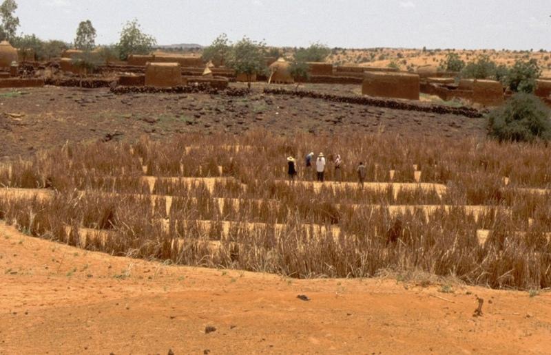
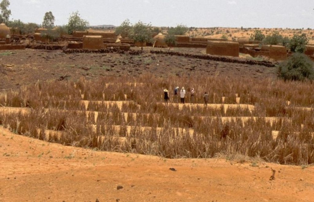
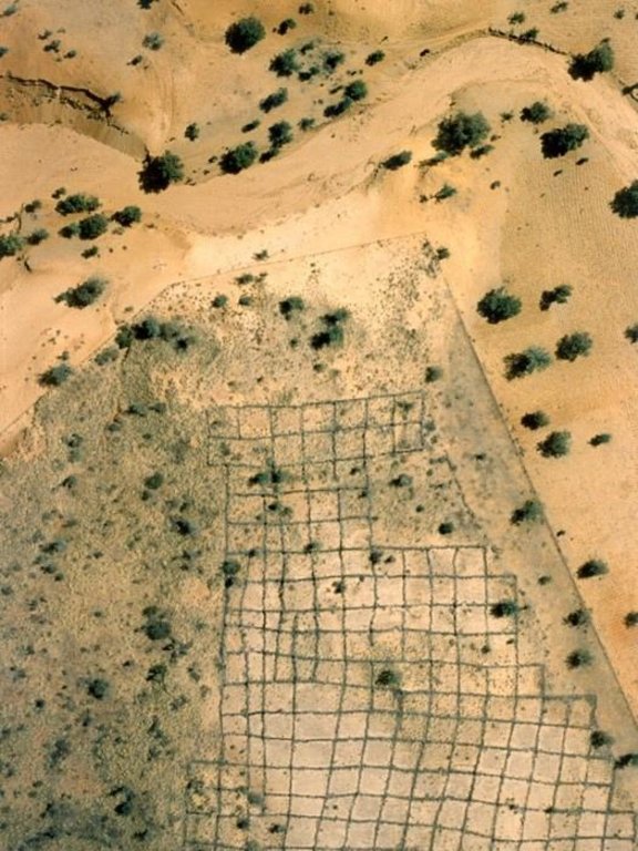
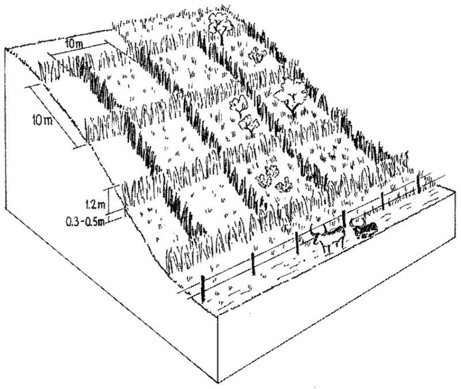
Purpose of the Technology: Sustainable dune fixation requires the regeneration of vegetation on the mobile parts of the dunes. For plants to establish, the dunes need to be protected by mechanical measures while being defended against any kind of use. Hence, the technique of dune stabilisation consists of a combination of three measures. These are as follows: (1) Area closure by wire fencing and guarding to prevent exploitation of the area during the rehabilitation phase until vegetation is sufficiently established (2-3 years). (2) Construction of millet stalk palisades arranged ideally in ‘checker-board’ squares, which act as windbreaks. These physical structures are a barrier to sand transport by wind, and thus are a prerequisite for revegetation. After two years the palisades fall apart and decompose - and the vegetation takes over the dune fixation function. Small erosion gullies can be controlled by check dams made from stone or millet stalks. (3) Natural regeneration, planting and seeding of annual and perennial plants (including Acacia spp. and Prosopis spp.) for soil stabilisation.
Establishment / maintenance activities and inputs: As soon as vegetation cover is established on the denuded surfaces the dunes can be used for grazing or for harvesting of herbs and fuelwood. Period and frequency of use should be determined in common agreement with all actors involved. In addition the pasture on the dune can be used as a ’reserve’ for late dry-season grazing, depending on vegetation development and herd size. Between 1991 and 1995, just over 250 ha of sand dunes were stabilised in the case study area. Incentives were provided by the ‘Projet de Développement Rural de Tahoua’ (PDRT, see also ‘Participatory land rehabilitation’ approach). After 1995 no further dunes were stabilised due to the high cost of the wire fencing, which local communities simply could not afford themselves. However, as the objective of the fence is to keep out humans and animals during critical periods (the rainy season), the same effect could be obtained at no financial cost through ‘social fencing’, that is agreement between stakeholders on where there should be no grazing. Furthermore the technology itself - which works well - could be relevant to situations where higher investment can be justified for specific reasons.
2.3 Photos of the Technology
2.5 Country/ region/ locations where the Technology has been applied and which are covered by this assessment
Country:
Niger
Region/ State/ Province:
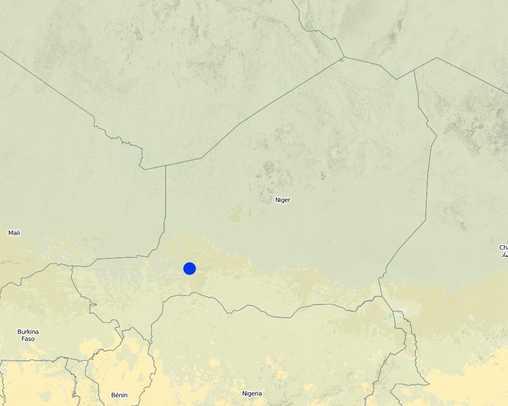
District of Tahoua
Map
×2.7 Introduction of the Technology
Specify how the Technology was introduced:
- through projects/ external interventions
3. Classification of the SLM Technology
3.1 Main purpose(s) of the Technology
- reduce, prevent, restore land degradation
- reduce loss of land
3.2 Current land use type(s) where the Technology is applied

Grazing land
Extensive grazing land:
- Semi-nomadism/ pastoralism
- Ranching
Comments:
Major land use problems (compiler’s opinion): The area suffers from an imbalance between availability of natural resources (constrained by soil fertility and rainfall) and the rapid growth of the human and livestock populations. As a result, there is chronic food insufficiency and an associated overexploitation of the natural resource base. Accelerated wind and water erosion further enhance the degradation of the soil resources. From the farmers’ perspective, the main problems are lack of grazing land, wood and drinking water (due to sinking water tables), insufficient and unevenly distributed rainfall. Sand dunes are fragile: when overexploited, they soon remain with only unpalatable plant species, eg Panicum turgidum. When the vegetation cover on dunes decreases even further, dunes start moving again, threatening fields, villages or depressions used for fruit and vegetable cropping.
3.3 Further information about land use
Water supply for the land on which the Technology is applied:
- rainfed
Specify:
Longest growing period in days: 90; Longest growing period from month to month: Jul - Sep
3.4 SLM group to which the Technology belongs
- area closure (stop use, support restoration)
- improved ground/ vegetation cover
3.5 Spread of the Technology
Comments:
Total area covered by the SLM Technology is 2 km2.
3.6 SLM measures comprising the Technology

vegetative measures
- V1: Tree and shrub cover

structural measures
- S6: Walls, barriers, palisades, fences

management measures
- M1: Change of land use type
3.7 Main types of land degradation addressed by the Technology

soil erosion by wind
- Et: loss of topsoil
- Eo: offsite degradation effects

chemical soil deterioration
- Cn: fertility decline and reduced organic matter content (not caused by erosion)

biological degradation
- Bs: quality and species composition/ diversity decline
Comments:
Main causes of degradation: droughts (manque de pluie; pluie mal répartie), land tenure, faim
Secondary causes of degradation: soil management (pas de jachère; pas suffisamment d'intrants. Mulching, engrais, mat. organique), deforestation / removal of natural vegetation (incl. forest fires) (combustibles), over-exploitation of vegetation for domestic use, overgrazing, population pressure (croissance de la population), poverty / wealth (Manque de moyens financiers), labour availability, education, access to knowledge and support services
3.8 Prevention, reduction, or restoration of land degradation
Specify the goal of the Technology with regard to land degradation:
- prevent land degradation
- restore/ rehabilitate severely degraded land
4. Technical specifications, implementation activities, inputs, and costs
4.1 Technical drawing of the Technology
4.2 Technical specifications/ explanations of technical drawing
Sand dunes in the process of stabilisation: millet stalk palisades hinder detachment and displacement of sand particles through wind, and help vegetative cover to re-establish. Fences exclude animals during the restoration process.
Technical knowledge required for field staff / advisors: moderate
Technical knowledge required for land users: low
Main technical functions: improvement of ground cover, sediment retention / trapping, sediment harvesting, reduction in wind speed, stabilise sand dune surface, control detachment of particles by wind
Secondary technical functions: increase in organic matter
Agronomic measure: regenerated and seeded vegetation cover
Structural measure: millet stalk palisades
Structural measure: check dams (optional)
Change of land use practices / intensity level: area closure, controlled grazing
4.3 General information regarding the calculation of inputs and costs
Specify currency used for cost calculations:
- US Dollars
4.4 Establishment activities
| Activity | Type of measure | Timing | |
|---|---|---|---|
| 1. | Construction of wire fence around the dune | Structural | December to June |
| 2. | Palisade construction, 2000 m/ha. | Structural | December to June |
| 3. | Guarding the fenced area | Management | all year round |
4.5 Costs and inputs needed for establishment
| Specify input | Unit | Quantity | Costs per Unit | Total costs per input | % of costs borne by land users | |
|---|---|---|---|---|---|---|
| Labour | Enclose area and protect | ha | 1.0 | 300.0 | 300.0 | 100.0 |
| Equipment | Tools | ha | 1.0 | 10.0 | 10.0 | |
| Plant material | Tree seedlings | ha | 1.0 | 20.0 | 20.0 | |
| Construction material | Wire fence | ha | 1.0 | 1120.0 | 1120.0 | |
| Total costs for establishment of the Technology | 1450.0 | |||||
Comments:
Duration of establishment phase: 36 month(s)
In the Sahelian zone of Niger, wind erosion constitutes one of the major causes of land degradation. Measures to combat wind erosion and sand encroachment were developed through a rural development project. However in this case the cost was too high to justify continuation: nevertheless the technology itself may be applicable in other situations
4.6 Maintenance/ recurrent activities
| Activity | Type of measure | Timing/ frequency | |
|---|---|---|---|
| 1. | Harvesting of millet stalks , 2,000 bundles/ha (1 bundle = 6-10 kg). | Agronomic | October to February / initial establishment |
| 2. | Seeding of herbaceous plants | Agronomic | May, just before rainy season / initial establishment |
| 3. | Transplanting of locally available trees reared in a tree nursery | Agronomic | June to July, early rainy season / initial establishment |
| 4. | Replanting of dead tree/shrub seedlings (20% replanting). | Agronomic | June to July / |
| 5. | Guarding the area closure | Management | all year round / |
| 6. | Controlled grazing once the dune has been stabilised: for periods of between 1 day and a week every 2 to 3 weeks – as determined | Management | / between 1 day and a week every 2 to 3 weeks |
4.7 Costs and inputs needed for maintenance/ recurrent activities (per year)
| Specify input | Unit | Quantity | Costs per Unit | Total costs per input | % of costs borne by land users | |
|---|---|---|---|---|---|---|
| Labour | Maintain area and guarding | ha | 1.0 | 45.0 | 45.0 | 100.0 |
| Plant material | Tree seedlings | ha | 1.0 | 5.0 | 5.0 | |
| Total costs for maintenance of the Technology | 50.0 | |||||
Comments:
Labour (per ha, for establishment) includes installing wire fence (16 person days), collecting and transporting millet stalks and installing palisades (175 person days), sowing of herbaceous plants (2 person days), planting tree/shrub species (6 person days). Seedlings: under PDRT the tree nursery was financed by the project and the plants delivered to the ‘village’ - planting was done by the local population.
5. Natural and human environment
5.1 Climate
Annual rainfall
- < 250 mm
- 251-500 mm
- 501-750 mm
- 751-1,000 mm
- 1,001-1,500 mm
- 1,501-2,000 mm
- 2,001-3,000 mm
- 3,001-4,000 mm
- > 4,000 mm
Specify average annual rainfall (if known), in mm:
300.00
Agro-climatic zone
- semi-arid
5.2 Topography
Slopes on average:
- flat (0-2%)
- gentle (3-5%)
- moderate (6-10%)
- rolling (11-15%)
- hilly (16-30%)
- steep (31-60%)
- very steep (>60%)
Landforms:
- plateau/plains
- ridges
- mountain slopes
- hill slopes
- footslopes
- valley floors
Altitudinal zone:
- 0-100 m a.s.l.
- 101-500 m a.s.l.
- 501-1,000 m a.s.l.
- 1,001-1,500 m a.s.l.
- 1,501-2,000 m a.s.l.
- 2,001-2,500 m a.s.l.
- 2,501-3,000 m a.s.l.
- 3,001-4,000 m a.s.l.
- > 4,000 m a.s.l.
5.3 Soils
Soil depth on average:
- very shallow (0-20 cm)
- shallow (21-50 cm)
- moderately deep (51-80 cm)
- deep (81-120 cm)
- very deep (> 120 cm)
Soil texture (topsoil):
- coarse/ light (sandy)
Topsoil organic matter:
- low (<1%)
If available, attach full soil description or specify the available information, e.g. soil type, soil PH/ acidity, Cation Exchange Capacity, nitrogen, salinity etc.
Soil fertility is low
Soil drainage / infiltration is good
5.6 Characteristics of land users applying the Technology
Market orientation of production system:
- mixed (subsistence/ commercial
Off-farm income:
- > 50% of all income
Indicate other relevant characteristics of the land users:
Off-farm income specification: due to out-migration of labour, commerce and also arts and crafts
5.7 Average area of land owned or leased by land users applying the Technology
- < 0.5 ha
- 0.5-1 ha
- 1-2 ha
- 2-5 ha
- 5-15 ha
- 15-50 ha
- 50-100 ha
- 100-500 ha
- 500-1,000 ha
- 1,000-10,000 ha
- > 10,000 ha
Comments:
Average area of land owned or leased by land users applying the Technology: Also 15-50 ha
5.8 Land ownership, land use rights, and water use rights
Land ownership:
- communal/ village
Land use rights:
- open access (unorganized)
6. Impacts and concluding statements
6.1 On-site impacts the Technology has shown
Socio-economic impacts
Production
wood production
production area
Comments/ specify:
temporary loss of land, reduced access to pastures
land management
Income and costs
expenses on agricultural inputs
Comments/ specify:
Millet stalks are taken from the fields where they have a function as mulch and fodder
workload
Other socio-economic impacts
initial costs
Socio-cultural impacts
community institutions
SLM/ land degradation knowledge
conflict mitigation
Comments/ specify:
Socio-cultural conflicts between agriculturalists and pastoralists
requires concerted action
Comments/ specify:
Requires concerted action from all land users during, but even more after, rehabilitation
Ecological impacts
Soil
soil moisture
soil cover
soil loss
Climate and disaster risk reduction
wind velocity
Other ecological impacts
soil fertility
biodiversity
soil erosion locally
6.2 Off-site impacts the Technology has shown
wind transported sediments
land or village protected from sand encroachment
Comments regarding impact assessment:
Off-site benefits are difficult to assess and do not necessarily accrue to the local land users
6.4 Cost-benefit analysis
How do the benefits compare with the establishment costs (from land users’ perspective)?
Short-term returns:
very negative
Long-term returns:
negative
How do the benefits compare with the maintenance/ recurrent costs (from land users' perspective)?
Short-term returns:
negative
Long-term returns:
negative
6.5 Adoption of the Technology
Of all those who have adopted the Technology, how many have did so spontaneously, i.e. without receiving any material incentives/ payments?
- 0-10%
Comments:
There is no trend towards spontaneous adoption of the Technology
Comments on adoption trend: There is no spontaneous adoption as the technology is too expensive, labour intensive, and implemented on communal land.
6.7 Strengths/ advantages/ opportunities of the Technology
| Strengths/ advantages/ opportunities in the compiler’s or other key resource person’s view |
|---|
|
Technically it is feasible to prevent dune encroachment and hence reduce the danger it exerts on arable/pastoral land and villages How can they be sustained / enhanced? Prevent overexploitation, apply SWC measures that are technically and financially feasible (eg use cheaper fencing material or ‘social fencing’). |
|
Decrease loss of arable/pastoral land How can they be sustained / enhanced? Prevent overexploitation. |
|
Additional income to the land user How can they be sustained / enhanced? Planting multipurpose tree/shrub species on the protected dunes, encourage pasture management systems eg rotational grazing. |
6.8 Weaknesses/ disadvantages/ risks of the Technology and ways of overcoming them
| Weaknesses/ disadvantages/ risks in the compiler’s or other key resource person’s view | How can they be overcome? |
|---|---|
| Soil cover is very sensitive to overexploitation |
In order to increase acceptance, involve the whole community in the planning and management processes of the stabilised dune. |
| Social conflicts between farmers and herders due to area closure | In order to increase acceptance, involve all actors, including pastoralists or their representatives, in the planning and management process of the stabilised dune. |
|
Use materials for the palisades that do not have an alternative use as fodder (as millet stalks do) for example twigs of Leptadenia pyrotechnica). Plastic nets exist for making palisades, but these are very expensive. Labour requirements difficult to circumvent. |
Initiate the establishment of sustainable management systems eg communally managed rotational grazing systems. |
|
Area closure to prevent exploitation of stabilised dunes means restricted access to potential grazing areas |
Involved actors can agree upon a local convention that prohibits access during rehabilitation – ‘social fencing’ – and restricted exploitation after this phase. PDRT started to plant Euphorbia balsamifera within the fence with the idea of eventually removing and using it on another site. |
| High costs for fencing |
Links and modules
Expand all Collapse allLinks

Participatory land rehabilitation [Niger]
Planning and management of individual and village land, based on land users' participation, with simultaneous promotion of women's activities.
- Compiler: Eric Tielkes
Modules
No modules


