Water Storage Bank in small-scale agricultural areas [Thailand]
- Creation:
- Update:
- Compiler: Bunjirtluk Jintaridth
- Editor: –
- Reviewer: Rima Mekdaschi Studer
Bo Bao Kanomkrok
technologies_4123 - Thailand
View sections
Expand all Collapse all1. General information
1.2 Contact details of resource persons and institutions involved in the assessment and documentation of the Technology
Key resource person(s)
SLM specialist:
Suriyawongpongsa Munthana
(66)87391298 / 66816319368
musu_98@hotmail.com / -
Nakornnayok Station, Land Development Department (Regional 1)
Nakhon Nayok Province, THAILAND
Thailand
SLM specialist:
Jintaridth Bunjirtluk
(66)982523431 / -
jintaridth@yahoo.com / -
Land Development Department
156/1 Paholyothin Rd., Jatujak, Bangkok 10900
Thailand
SLM specialist:
Na Lampang Ratikorn
- / -
ratikorn_na@hotmail.com / -
Land Development Department
-
Thailand
land user:
Ketkaew Sommai
- / -
- / -
Tung Kra Prong Study Center
287 Moo 12 , Paka Tumbon, Banna Amphoe, Nakornnayok province
Thailand
1.3 Conditions regarding the use of data documented through WOCAT
When were the data compiled (in the field)?
13/09/2018
The compiler and key resource person(s) accept the conditions regarding the use of data documented through WOCAT:
Yes
1.4 Declaration on sustainability of the described Technology
Is the Technology described here problematic with regard to land degradation, so that it cannot be declared a sustainable land management technology?
No
2. Description of the SLM Technology
2.1 Short description of the Technology
Definition of the Technology:
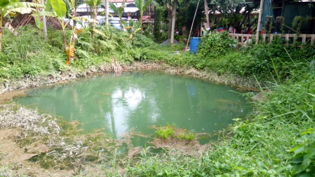
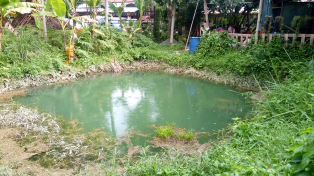
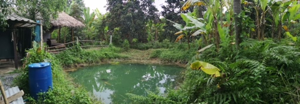
Bo Bao Kanomkrok is the well drilled as a source of water for agricultural purpose. It is drilled in a form of quadrilateral to store water in the flooding season and to prevent water from drying up in the area, including increasing agricultural activities in the dry season.
2.2 Detailed description of the Technology
Description:
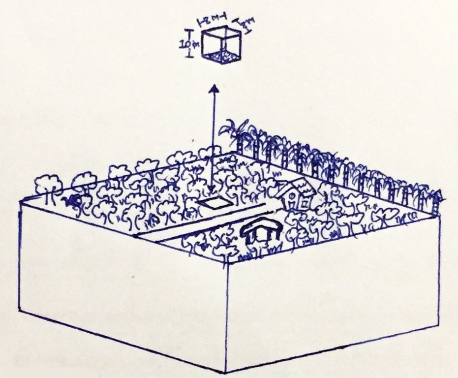
Bo Bao Kanomkrok is the well drilled as a source of water for agricultural purpose. It is drilled in a form of quadrilateral to store water in the flooding season and to prevent water from drying up in the area, including increasing agricultural activities in the dry season. Moreover, Bo Bao Kanomkrok is drilled in the agricultural area with the dimension of: 8 meters width, 8 meters length and 10 meters depth. It has the capacity of 640 m3 to be used in the agricultural area of about 6 rai. Water is available through the dry season all year long. The well is to be drilled vertically with no slope. When the well is completely drilled, muddy soil is coated around the drilled well in order to prevent water from seeping. Plants are grown around the edge of the drilled well to prevent the drilled well from collapsing.
This technology is the This technology is the extension that receives benefits from building the dam whereby the dam will replenish and increase the amount of water
Therefore, Bo Bao Kanomkrok is an appropriate alternative and low costs in storing water to use in the small-scale agricultural area. It is a good prototype for extending to other agricultural plots in the community and adjacent communities. in the well sufficiently in the small-scale agricultural area consisting of fruit-bearing trees, perennial crops and vegetables such as sweet yellow marian plums, durians, santols, hairy-leafed apitongs, Barking Deer's Mango, hedge bamboo, Paco fern, bananas, Garcinia cowa, Brazilian Pepper-tree etc. Ban Thung Krapong Learning Center, Nakhon Nayok province is the prototype community arising from learning to solve problems by themselves and studying from the nature and the environment in the community.
Bo Bao Kanomkrok must be maintained from the owner so that it will have efficiency in storing water throughout the year. Choosing the area to drill requires experiences and expertise in choosing the area with spring. For the dam, it is one part to refill Bo Bao Kanomkrok for enough water usage throughout the year.
themselves and studying from the nature and the environment in the community.
Production and Socio-economic Aspect Quality, variety of productivity and production areas increase by managing the land more systematically, resulting in increasing agricultural products and incomes. Social and Cultural aspect Increasing food security, resulting in self-dependency, health improvement of people in the community and lessening the conflict of water usage in the community in order to build and increase more strength to the community institution
Ecosystem Aspect Amount of water and the level of underground water increase. Reducing soil losses, resulting in more moisture in the soil. Various plants cover the area more. Organic matters in the soil increase. The impacts of flooding and drought are lessened. Indirect benefits Water flows steadily and constantly in the dry season, which makes the management of soil, plant and areas have maximum benefits
Bo Bao Kanomkrok is an appropriate alternative and low costs in storing water to use in the small-scale agricultural area. It is a good prototype for extending to other agricultural plots in the community and adjacent communities.
Bo Bao Kanomkrok must be maintained from the owner so that it will have efficiency in storing water throughout the year. Choosing the area to drill requires experiences and expertise in choosing the area with spring. For the dam, it is one part to refill Bo Bao Kanomkrok for enough water usage throughout the year.
2.3 Photos of the Technology
2.5 Country/ region/ locations where the Technology has been applied and which are covered by this assessment
Country:
Thailand
Region/ State/ Province:
Nakhon Nayok
Further specification of location:
Ban Thung Krapong Learning Center, Nakhon Nayok province
Map
×2.6 Date of implementation
Indicate year of implementation:
87
If precise year is not known, indicate approximate date:
- 10-50 years ago
2.7 Introduction of the Technology
Specify how the Technology was introduced:
- through land users' innovation
Comments (type of project, etc.):
Study this technology from Khao Hin Son Royal Development Center
3. Classification of the SLM Technology
3.1 Main purpose(s) of the Technology
- improve production
- reduce, prevent, restore land degradation
- conserve ecosystem
- protect a watershed/ downstream areas – in combination with other Technologies
- preserve/ improve biodiversity
- reduce risk of disasters
- adapt to climate change/ extremes and its impacts
- mitigate climate change and its impacts
- create beneficial economic impact
- create beneficial social impact
3.2 Current land use type(s) where the Technology is applied

Cropland
- Annual cropping
- Perennial (non-woody) cropping
- Tree and shrub cropping

Mixed (crops/ grazing/ trees), incl. agroforestry
- Agroforestry
Main products/ services:
Rubber, Ornamental plants
Comments:
Annual cropping
3.3 Further information about land use
Water supply for the land on which the Technology is applied:
- rainfed
Number of growing seasons per year:
- 1
3.4 SLM group to which the Technology belongs
- water harvesting
3.5 Spread of the Technology
Specify the spread of the Technology:
- evenly spread over an area
If the Technology is evenly spread over an area, indicate approximate area covered:
- 1-10 km2
3.6 SLM measures comprising the Technology

structural measures
- S7: Water harvesting/ supply/ irrigation equipment
3.7 Main types of land degradation addressed by the Technology

soil erosion by water
- Wo: offsite degradation effects
Comments:
In long term, they were found that there are accumulation from sediments inside the well. Therefore, we have to dig out from them.
3.8 Prevention, reduction, or restoration of land degradation
Specify the goal of the Technology with regard to land degradation:
- prevent land degradation
- reduce land degradation
4. Technical specifications, implementation activities, inputs, and costs
4.1 Technical drawing of the Technology
4.2 Technical specifications/ explanations of technical drawing
Type of Bo Bao Kanomkrok drilled in the small-scale agricultural area with the capacity of 640 m3 for using in the agricultural area of about 6 rai. At present, there were this type of wells-Bo Bao Kanomkrok accounting for 81 wells. Costs of digging a Bo Bao Kanomkrok are around 7,000 Baht.
4.3 General information regarding the calculation of inputs and costs
Specify how costs and inputs were calculated:
- per Technology area
Indicate size and area unit:
6 rais
Indicate exchange rate from USD to local currency (if relevant): 1 USD =:
32.0
Indicate average wage cost of hired labour per day:
600 Baht per day
4.4 Establishment activities
| Activity | Type of measure | Timing | |
|---|---|---|---|
| 1. | Labour cost | Structural | Before onset of rains |
| 2. | Backhoe | Structural | Before onset of rains |
4.5 Costs and inputs needed for establishment
| Specify input | Unit | Quantity | Costs per Unit | Total costs per input | % of costs borne by land users | |
|---|---|---|---|---|---|---|
| Labour | labour cost for digging sediments out from well | people | 4.0 | 600.0 | 2400.0 | 100.0 |
| Labour | Labour for driving Backhoe | hours | 3.0 | 1200.0 | 3600.0 | 100.0 |
| Total costs for establishment of the Technology | 6000.0 | |||||
4.6 Maintenance/ recurrent activities
| Activity | Type of measure | Timing/ frequency | |
|---|---|---|---|
| 1. | In long term, they were found that there is accumulation from sediments inside the well. Therefore, we have to dig out from them. | Structural | once per 10 years |
4.7 Costs and inputs needed for maintenance/ recurrent activities (per year)
| Specify input | Unit | Quantity | Costs per Unit | Total costs per input | % of costs borne by land users | |
|---|---|---|---|---|---|---|
| Equipment | Backhoe | hour | 1.0 | 1200.0 | 1200.0 | 100.0 |
| Total costs for maintenance of the Technology | 1200.0 | |||||
4.8 Most important factors affecting the costs
Describe the most determinate factors affecting the costs:
The amount of sediments
5. Natural and human environment
5.1 Climate
Annual rainfall
- < 250 mm
- 251-500 mm
- 501-750 mm
- 751-1,000 mm
- 1,001-1,500 mm
- 1,501-2,000 mm
- 2,001-3,000 mm
- 3,001-4,000 mm
- > 4,000 mm
Specify average annual rainfall (if known), in mm:
1500.00
Specifications/ comments on rainfall:
Rainfall season is between May to October and Heavy rainfall is during August and September
Indicate the name of the reference meteorological station considered:
Ministry of Meteorological
Agro-climatic zone
- sub-humid
5.2 Topography
Slopes on average:
- flat (0-2%)
- gentle (3-5%)
- moderate (6-10%)
- rolling (11-15%)
- hilly (16-30%)
- steep (31-60%)
- very steep (>60%)
Landforms:
- plateau/plains
- ridges
- mountain slopes
- hill slopes
- footslopes
- valley floors
Altitudinal zone:
- 0-100 m a.s.l.
- 101-500 m a.s.l.
- 501-1,000 m a.s.l.
- 1,001-1,500 m a.s.l.
- 1,501-2,000 m a.s.l.
- 2,001-2,500 m a.s.l.
- 2,501-3,000 m a.s.l.
- 3,001-4,000 m a.s.l.
- > 4,000 m a.s.l.
5.3 Soils
Soil depth on average:
- very shallow (0-20 cm)
- shallow (21-50 cm)
- moderately deep (51-80 cm)
- deep (81-120 cm)
- very deep (> 120 cm)
Soil texture (topsoil):
- medium (loamy, silty)
Soil texture (> 20 cm below surface):
- medium (loamy, silty)
Topsoil organic matter:
- high (>3%)
5.4 Water availability and quality
Ground water table:
5-50 m
Availability of surface water:
good
Water quality (untreated):
for agricultural use only (irrigation)
Is water salinity a problem?
Yes
Is flooding of the area occurring?
Yes
Regularity:
frequently
5.5 Biodiversity
Species diversity:
- medium
Habitat diversity:
- medium
Comments and further specifications on biodiversity:
Variety of plants
5.6 Characteristics of land users applying the Technology
Sedentary or nomadic:
- Sedentary
Market orientation of production system:
- mixed (subsistence/ commercial
Off-farm income:
- > 50% of all income
Relative level of wealth:
- average
Individuals or groups:
- individual/ household
Level of mechanization:
- manual work
Gender:
- men
Age of land users:
- middle-aged
5.7 Average area of land owned or leased by land users applying the Technology
- < 0.5 ha
- 0.5-1 ha
- 1-2 ha
- 2-5 ha
- 5-15 ha
- 15-50 ha
- 50-100 ha
- 100-500 ha
- 500-1,000 ha
- 1,000-10,000 ha
- > 10,000 ha
Is this considered small-, medium- or large-scale (referring to local context)?
- small-scale
5.8 Land ownership, land use rights, and water use rights
Land ownership:
- individual, titled
Land use rights:
- individual
Water use rights:
- individual
5.9 Access to services and infrastructure
health:
- poor
- moderate
- good
education:
- poor
- moderate
- good
technical assistance:
- poor
- moderate
- good
employment (e.g. off-farm):
- poor
- moderate
- good
markets:
- poor
- moderate
- good
energy:
- poor
- moderate
- good
roads and transport:
- poor
- moderate
- good
drinking water and sanitation:
- poor
- moderate
- good
financial services:
- poor
- moderate
- good
6. Impacts and concluding statements
6.1 On-site impacts the Technology has shown
Socio-economic impacts
Production
crop production
crop quality
product diversity
Comments/ specify:
more diversity of plants
production area
Comments/ specify:
areas of plants increase
land management
Comments/ specify:
more easier of soil management
Water availability and quality
water availability for livestock
irrigation water availability
Income and costs
expenses on agricultural inputs
farm income
diversity of income sources
Socio-cultural impacts
food security/ self-sufficiency
health situation
land use/ water rights
community institutions
conflict mitigation
Ecological impacts
Water cycle/ runoff
water quantity
groundwater table/ aquifer
Soil
soil moisture
soil cover
soil loss
soil organic matter/ below ground C
6.2 Off-site impacts the Technology has shown
reliable and stable stream flows in dry season
buffering/ filtering capacity
6.3 Exposure and sensitivity of the Technology to gradual climate change and climate-related extremes/ disasters (as perceived by land users)
Gradual climate change
Gradual climate change
| Season | Type of climatic change/ extreme | How does the Technology cope with it? | |
|---|---|---|---|
| annual temperature | increase | very well | |
| seasonal temperature | dry season | increase | very well |
Climate-related extremes (disasters)
Meteorological disasters
| How does the Technology cope with it? | |
|---|---|
| tropical storm | very well |
| extra-tropical cyclone | very well |
| local rainstorm | very well |
| local thunderstorm | very well |
Hydrological disasters
| How does the Technology cope with it? | |
|---|---|
| general (river) flood | very well |
| flash flood | very well |
| storm surge/ coastal flood | very well |
Biological disasters
| How does the Technology cope with it? | |
|---|---|
| epidemic diseases | not known |
| insect/ worm infestation | not known |
Other climate-related consequences
Other climate-related consequences
| How does the Technology cope with it? | |
|---|---|
| extended growing period | very well |
| reduced growing period | very well |
6.4 Cost-benefit analysis
How do the benefits compare with the establishment costs (from land users’ perspective)?
Short-term returns:
very positive
Long-term returns:
very positive
How do the benefits compare with the maintenance/ recurrent costs (from land users' perspective)?
Short-term returns:
very positive
Long-term returns:
very positive
6.5 Adoption of the Technology
- more than 50%
If available, quantify (no. of households and/ or area covered):
87 (110 )
Of all those who have adopted the Technology, how many have did so spontaneously, i.e. without receiving any material incentives/ payments?
- 90-100%
6.6 Adaptation
Has the Technology been modified recently to adapt to changing conditions?
Yes
Specify adaptation of the Technology (design, material/ species, etc.):
Land Use Change
6.7 Strengths/ advantages/ opportunities of the Technology
| Strengths/ advantages/ opportunities in the land user’s view |
|---|
| Bo Bao Kanomkrok is an appropriate alternative and low costs in storing water to use in the small-scale agricultural area. |
| It is a good prototype for extending to other agricultural plots in the community and adjacent communities. |
| Strengths/ advantages/ opportunities in the compiler’s or other key resource person’s view |
|---|
| Good for farmers for keeping water throughout the year |
| Due to Water storage for small scale of agriculture, therefore they can increase yield and income. |
| benefit for farmers doing small farm ponds for their own food. |
6.8 Weaknesses/ disadvantages/ risks of the Technology and ways of overcoming them
| Weaknesses/ disadvantages/ risks in the land user’s view | How can they be overcome? |
|---|---|
| It must be maintained from the owner so that it will have efficiency in storing water throughout the year. | |
| Choosing the area to drill requires experiences and expertise in choosing the area with spring. | |
| For the dam, it is one part to refill Bo Bao Kanomkrok for enough water usage throughout the year. |
| Weaknesses/ disadvantages/ risks in the compiler’s or other key resource person’s view | How can they be overcome? |
|---|---|
| Because of sediments in each year can be impact to the amount of water | Dig the sediments out of ponds each year |
7. References and links
7.1 Methods/ sources of information
- field visits, field surveys
5 persons
- interviews with land users
1 person
- interviews with SLM specialists/ experts
4 persons
- compilation from reports and other existing documentation
1 persons
7.2 References to available publications
Title, author, year, ISBN:
-
Available from where? Costs?
-
7.3 Links to relevant information which is available online
Title/ description:
Ban Tung Kraprong Study Center Project
URL:
http:\\www.1ldd.go.th/WEB_PSD/prnew/2561/sr1-61/sr2.pdf
Links and modules
Expand all Collapse allLinks
No links
Modules
No modules


