Gully Treatment [Burkina Faso]
- Creation:
- Update:
- Compiler: Moussa ABOU
- Editors: Brice Sosthène BAYALA, Siagbé Golli, Tabitha Nekesa, Ahmadou Gaye
- Reviewers: Sally Bunning, Rima Mekdaschi Studer, William Critchley
technologies_6722 - Burkina Faso
View sections
Expand all Collapse all1. General information
1.2 Contact details of resource persons and institutions involved in the assessment and documentation of the Technology
Key resource person(s)
land user:
MILLOGO Joseph
Burkina Faso
land user:
MILLOGO Herman
Burkina Faso
land user:
TRAORE Ouranza
Burkina Faso
Name of project which facilitated the documentation/ evaluation of the Technology (if relevant)
Soil protection and rehabilitation for food security (ProSo(i)l)Name of the institution(s) which facilitated the documentation/ evaluation of the Technology (if relevant)
Deutsche Gesellschaft für Internationale Zusammenarbeit (GIZ)1.3 Conditions regarding the use of data documented through WOCAT
The compiler and key resource person(s) accept the conditions regarding the use of data documented through WOCAT:
Yes
1.4 Declaration on sustainability of the described Technology
Is the Technology described here problematic with regard to land degradation, so that it cannot be declared a sustainable land management technology?
No
2. Description of the SLM Technology
2.1 Short description of the Technology
Definition of the Technology:
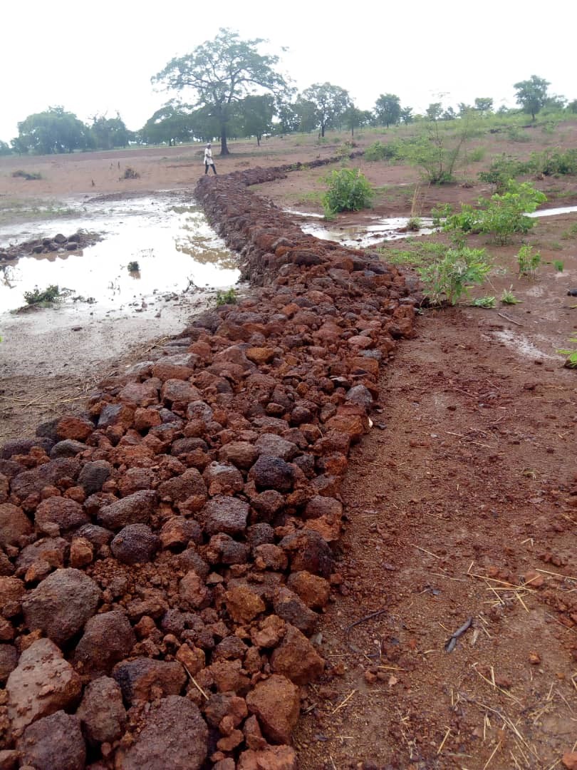
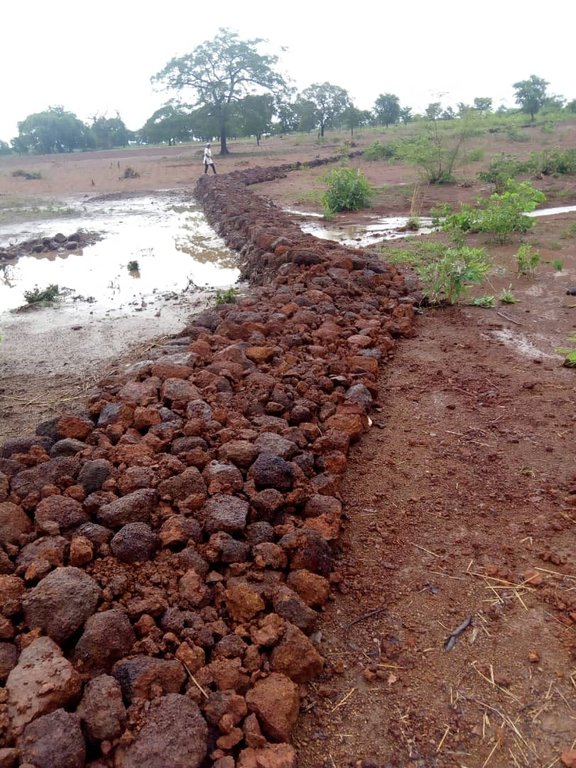
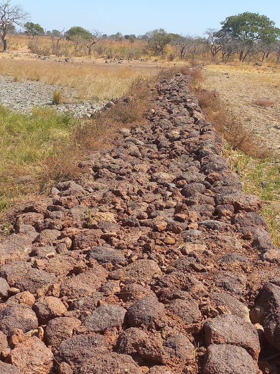
Gully treatment consists in lining the walls of a gully and creating a partial barrier within the gully using stone check dams and, if necessary, earth-filled bags.
2.2 Detailed description of the Technology
Description:
Gully erosion is the removal of soil along drainage lines by surface water runoff when stripped of protective vegetation. If stabilization measures are not implemented, gullies will persist in eroding deeper through regressive erosion or sidewall subsidence, eventually becoming very deep in fragile sedimentary soils. It is much easier and more economical to carry out repair work in the early stages of newly formed gullies. Large, uncontrolled gullies are difficult and costly to repair. Gully treatment is achieved through reducing runoff speed, thus preventing linear soil erosion and the loss of productive land.
Dry stone check dams are well suited to small gullies up to 2 m wide and 1 m deep, with a gentle to medium slope and a medium-soft to hard substrate, and are recommended for cultivated land, reforestation areas, rangelands, etc. But these structures are not suitable for larger gullies, with steep slopes and a very fragile substrate.
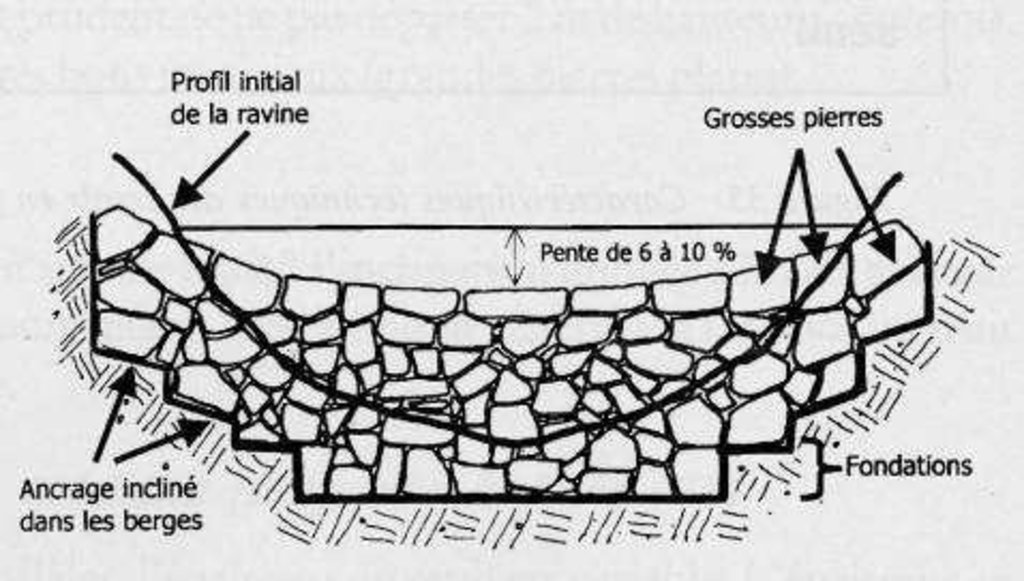
The height of each stone check dam depends on local conditions but should never exceed 1.50 m in height. The length depends on the gully's cross-section (width and shape). A check dam’s width should vary according to the volume of water passing through the gully. Wings of stone (higher than the centre point of the check dam) should be securely anchored into gully banks to enhance rigidity and stability and to prevent water flowing around the check dam and creating new gullies to either side.
The purpose of check dams is to slow down water velocity, dissipate its energy, prevent erosion, and induce sedimentation upstream. This process helps reduce the gully slope and facilitates re-vegetation. In the case of deep gullies with filled check dams upstream, another series of check dams can be built to create a stable parabolic section for water passage and re-vegetation with protective species.
This technology makes it possible to control gullying, encourage infiltration and conserve soil moisture, while contributing to groundwater recharge and land reclamation.
The main activities involved in gully treatment are as follows:
•Designing the structure;
•Marking contour lines perpendicular to the gully using a watertube level or an A-Frame;
•Determining the size of spillway (area of origin and estimated volume of runoff);
•Determining the height of the gully and the width of the section to be treated (equal to 2 or 3 times the height of the gully);
•Building the structures;
•Excavating the anchoring trench: dig down to a depth of 10 to 20 cm over the width of the section to be treated (the earth resulting from the excavation is deposited upstream);
•Building the check dam, starting with a layer of gravel, followed by large stones at the bottom, then progressively medium-sized stones and finally small rubble stones;
•Building wings at the sides of the check dams, following the contour line and using small stones and earth-filled sacks.
The inputs needed to implement this technology are soil, stones, gravel and rubble, as well as wheelbarrows, pickaxes, pegs, etc. Experienced manpower is required and access to a vehicle may be needed to transport the inputs.
The technology is suitable for all types of soil and landforms, easy to build and inexpensive, but only if stone is readily available. In addition, it has an immediate impact on the evolution of the gully, correcting the slope and helping reduce flow velocity, thereby controlling the gullying process. It promotes infiltration, conserves soil moisture, contributes to groundwater recharge and reclaims land (especially gully slopes for useful vegetation such as bamboo, vetiver or fodder grasses). It requires maintenance at the start of the rainy season and regular visits to check that it is working properly.
Farmers claim that this technology significantly increases their crop yields through water infiltration and groundwater recovery. However, they acknowledge the substantial financial and human resources required for gully treatment, emphasizing the need for support from development partners for its widespread adoption.
2.3 Photos of the Technology
2.5 Country/ region/ locations where the Technology has been applied and which are covered by this assessment
Country:
Burkina Faso
Region/ State/ Province:
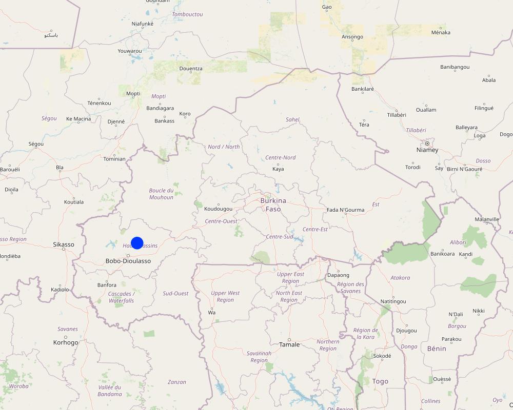
Hauts-Bassins, Houet Province
Further specification of location:
Tiarako (Commune of Satiri)
Specify the spread of the Technology:
- evenly spread over an area
If precise area is not known, indicate approximate area covered:
- 0.1-1 km2
Is/are the technology site(s) located in a permanently protected area?
No
Map
×2.6 Date of implementation
If precise year is not known, indicate approximate date:
- less than 10 years ago (recently)
2.7 Introduction of the Technology
Specify how the Technology was introduced:
- through projects/ external interventions
Comments (type of project, etc.):
Gully treatment is a technology promoted by ProSoil.
3. Classification of the SLM Technology
3.1 Main purpose(s) of the Technology
- reduce, prevent, restore land degradation
- preserve/ improve biodiversity
- reduce risk of disasters
- create beneficial economic impact
3.2 Current land use type(s) where the Technology is applied
Land use mixed within the same land unit:
Yes
Specify mixed land use (crops/ grazing/ trees):
- Agroforestry

Cropland
- Annual cropping
- Tree and shrub cropping
Annual cropping - Specify crops:
- cereals - maize
- cereals - sorghum
- fibre crops - cotton
Tree and shrub cropping - Specify crops:
- grapes
- karite (sheanut)
Number of growing seasons per year:
- 1
Is intercropping practiced?
No
Is crop rotation practiced?
Yes
If yes, specify:
Cotton, maize, and sorghum
3.3 Has land use changed due to the implementation of the Technology?
Has land use changed due to the implementation of the Technology?
- No (Continue with question 3.4)
3.4 Water supply
Water supply for the land on which the Technology is applied:
- rainfed
3.5 SLM group to which the Technology belongs
- cross-slope measure
3.6 SLM measures comprising the Technology

structural measures
- S2: Bunds, banks
- S6: Walls, barriers, palisades, fences
3.7 Main types of land degradation addressed by the Technology

soil erosion by water
- Wt: loss of topsoil/ surface erosion
- Wg: gully erosion/ gullying

soil erosion by wind
- Et: loss of topsoil
- Ed: deflation and deposition
- Eo: offsite degradation effects
3.8 Prevention, reduction, or restoration of land degradation
Specify the goal of the Technology with regard to land degradation:
- prevent land degradation
- reduce land degradation
4. Technical specifications, implementation activities, inputs, and costs
4.1 Technical drawing of the Technology
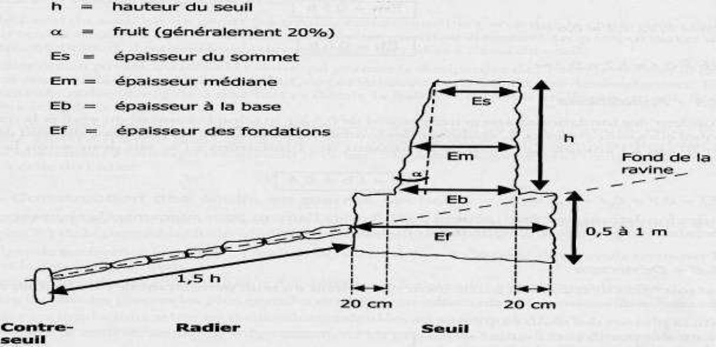
Technical specifications (related to technical drawing):
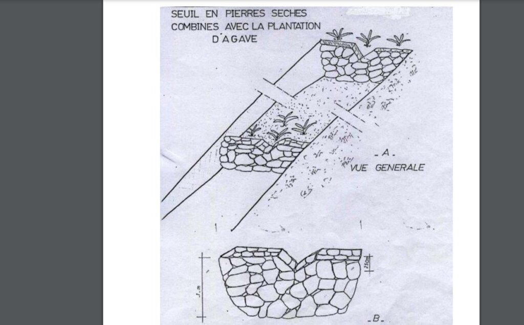
•The length and width of the ravine depend on the cross-section of the gully.
•Threshold height (Hs): 1.50 m maximum.
•Threshold thickness (Es): 1 m at the base.
•Length of the well-compacted stone block excavation mat downstream of the threshold (lt) between 1 and 1.50 m.
•Weir thickness (Ed): 1 m.
•Weir height (Hd): 0.50 m.
•Weir downstream slope (P): 20%.
The distance between weirs in the gully depends on the longitudinal slope of the gully and the height to be applied to the structure
Author:
ALI BLALI
Date:
2011
Technical specifications (related to technical drawing):
Longitudinal section of a dry stone threshold.
The stones must be carefully placed to guarantee stability of the structure.
Weirs can also be built with pegs and fascines (branches), gabions (wire cages filled with rubble) or cement, with the help of an expert in rural or civil engineering.
Author:
ALI BLALI
Date:
2011
4.2 General information regarding the calculation of inputs and costs
Specify how costs and inputs were calculated:
- per Technology unit
Specify unit:
Linear meter
If relevant, indicate exchange rate from USD to local currency (e.g. 1 USD = 79.9 Brazilian Real): 1 USD =:
613.5
Indicate average wage cost of hired labour per day:
CFA F 4333.67/linear meter
4.3 Establishment activities
| Activity | Timing (season) | |
|---|---|---|
| 1. | Establishment | Dry season |
| 2. | Determination of the right-of-way | Dry season |
| 3. | Excavation of the anchoring trench | Dry season |
| 4. | Installation of stone blocks | Dry season |
4.4 Costs and inputs needed for establishment
| Specify input | Unit | Quantity | Costs per Unit | Total costs per input | % of costs borne by land users | |
|---|---|---|---|---|---|---|
| Labour | Establishment | Linear meter | 1.0 | 166.67 | 166.67 | |
| Labour | Opening of trenches and construction | Linear meter | 1.0 | 4166.67 | 4166.67 | |
| Equipment | Small equipment costs | Linear meter | 1.0 | 833.33 | 833.33 | |
| Construction material | Purchase of stone blocks | Linear meter | 1.0 | 10000.0 | 10000.0 | |
| Other | Monitoring costs | Linear meter | 1.0 | 555.56 | 555.56 | |
| Other | Coordination costs | Linear meter | 1.0 | 277.78 | 277.78 | |
| Total costs for establishment of the Technology | 16000.01 | |||||
| Total costs for establishment of the Technology in USD | 26.08 | |||||
4.5 Maintenance/ recurrent activities
| Activity | Timing/ frequency | |
|---|---|---|
| 1. | Maintenance of the bund | Before the rainy season |
Comments:
To be durable, erosion control structures need maintenance. It is therefore necessary to raise awareness among the population about the need to plow parallel to contour lines, to isolate the structures by 0.5 m on either side, and to organize maintenance and repair work at the start of each campaign. This maintenance and repair work consists of replacing rubble that has been displaced by human or animal intervention.
4.6 Costs and inputs needed for maintenance/ recurrent activities (per year)
| Specify input | Unit | Quantity | Costs per Unit | Total costs per input | % of costs borne by land users | |
|---|---|---|---|---|---|---|
| Other | Gully maintenance and repair | Linear meter | 1.0 | 555.56 | 555.56 | 100.0 |
| Total costs for maintenance of the Technology | 555.56 | |||||
| Total costs for maintenance of the Technology in USD | 0.91 | |||||
Comments:
Technological maintenance involves replacing stones that have been displaced by human or animal intervention.
4.7 Most important factors affecting the costs
Describe the most determinate factors affecting the costs:
Proximity to stone blocks and availability of labor are the most important factors affecting costs.
5. Natural and human environment
5.1 Climate
Annual rainfall
- < 250 mm
- 251-500 mm
- 501-750 mm
- 751-1,000 mm
- 1,001-1,500 mm
- 1,501-2,000 mm
- 2,001-3,000 mm
- 3,001-4,000 mm
- > 4,000 mm
Specify average annual rainfall (if known), in mm:
900.00
Specifications/ comments on rainfall:
The Hauts-Bassins region, where the village of Tiarako (commune of Satiri) is located, experiences a tropical North-Sudanese and South-Sudanese climate. This climate is characterized by two (02) main seasons: a wet season lasting 06 to 07 months (May to October/November) and a dry season lasting 05 to 06 months (November/December to April). Annual rainfall is relatively abundant, ranging from 800 to 1200 mm.
Indicate the name of the reference meteorological station considered:
Satiri Rainfall Station
Agro-climatic zone
- sub-humid
Average temperatures vary between 24°c and 30°c, with a relatively small temperature range of 5°c.
5.2 Topography
Slopes on average:
- flat (0-2%)
- gentle (3-5%)
- moderate (6-10%)
- rolling (11-15%)
- hilly (16-30%)
- steep (31-60%)
- very steep (>60%)
Landforms:
- plateau/plains
- ridges
- mountain slopes
- hill slopes
- footslopes
- valley floors
Altitudinal zone:
- 0-100 m a.s.l.
- 101-500 m a.s.l.
- 501-1,000 m a.s.l.
- 1,001-1,500 m a.s.l.
- 1,501-2,000 m a.s.l.
- 2,001-2,500 m a.s.l.
- 2,501-3,000 m a.s.l.
- 3,001-4,000 m a.s.l.
- > 4,000 m a.s.l.
Indicate if the Technology is specifically applied in:
- convex situations
Comments and further specifications on topography:
The site under consideration is located at an altitude of 347 m.
5.3 Soils
Soil depth on average:
- very shallow (0-20 cm)
- shallow (21-50 cm)
- moderately deep (51-80 cm)
- deep (81-120 cm)
- very deep (> 120 cm)
Soil texture (topsoil):
- coarse/ light (sandy)
- fine/ heavy (clay)
Soil texture (> 20 cm below surface):
- coarse/ light (sandy)
- fine/ heavy (clay)
Topsoil organic matter:
- medium (1-3%)
If available, attach full soil description or specify the available information, e.g. soil type, soil PH/ acidity, Cation Exchange Capacity, nitrogen, salinity etc.
The predominant soils in the area are tropical ferruginous soils with minimal or no leaching, primarily characterized by deep hydromorphic (waterlogging) features. The sandy-clay composition of these soils makes them susceptible to water erosion.
5.4 Water availability and quality
Ground water table:
5-50 m
Availability of surface water:
medium
Water quality (untreated):
poor drinking water (treatment required)
Water quality refers to:
both ground and surface water
Is water salinity a problem?
No
Is flooding of the area occurring?
No
5.5 Biodiversity
Species diversity:
- medium
Habitat diversity:
- medium
5.6 Characteristics of land users applying the Technology
Sedentary or nomadic:
- Sedentary
Market orientation of production system:
- mixed (subsistence/ commercial)
Off-farm income:
- less than 10% of all income
Relative level of wealth:
- average
Individuals or groups:
- groups/ community
Level of mechanization:
- animal traction
Gender:
- men
Age of land users:
- middle-aged
5.7 Average area of land used by land users applying the Technology
- < 0.5 ha
- 0.5-1 ha
- 1-2 ha
- 2-5 ha
- 5-15 ha
- 15-50 ha
- 50-100 ha
- 100-500 ha
- 500-1,000 ha
- 1,000-10,000 ha
- > 10,000 ha
Is this considered small-, medium- or large-scale (referring to local context)?
- medium-scale
5.8 Land ownership, land use rights, and water use rights
Land ownership:
- individual, not titled
Land use rights:
- open access (unorganized)
Water use rights:
- open access (unorganized)
- communal (organized)
Are land use rights based on a traditional legal system?
Yes
Specify:
Due to the sacred nature of the land, custom dictates that its management must not be subject to speculation.
Comments:
According to information gathered from the literature and interviews, land in the village of Tiarako is most commonly accessed through inheritance and borrowing. Other access methods (lending, renting and buying) do not seem to be widespread or perceptible.
5.9 Access to services and infrastructure
health:
- poor
- moderate
- good
education:
- poor
- moderate
- good
technical assistance:
- poor
- moderate
- good
employment (e.g. off-farm):
- poor
- moderate
- good
markets:
- poor
- moderate
- good
energy:
- poor
- moderate
- good
roads and transport:
- poor
- moderate
- good
drinking water and sanitation:
- poor
- moderate
- good
financial services:
- poor
- moderate
- good
6. Impacts and concluding statements
6.1 On-site impacts the Technology has shown
Socio-economic impacts
Production
crop production
Quantity before SLM:
15 to 20 bags
Quantity after SLM:
50 to 60 bags
Comments/ specify:
Farmers report that prior to implementing gully treatment, they yielded 15 to 20 bags of maize per hectare. However, following the adoption of this technology, their production has increased to a range of 30 to 40 bags per hectare. This improvement is attributed to a three-year process involving the use of specific seeds, organic fertilizer, and adherence to technical production schedules.
crop quality
Income and costs
expenses on agricultural inputs
Comments/ specify:
Increased soil organic matter due to sediment deposition results in lower input costs (urea and NPK).
farm income
Socio-cultural impacts
food security/ self-sufficiency
recreational opportunities
SLM/ land degradation knowledge
Ecological impacts
Water cycle/ runoff
surface runoff
groundwater table/ aquifer
Soil
soil cover
soil loss
soil organic matter/ below ground C
Comments/ specify:
The technology helps dissipate water energy through improved infiltration and enhances sedimentation, thereby increasing soil organic matter for improved agricultural use.
Climate and disaster risk reduction
flood impacts
Specify assessment of on-site impacts (measurements):
The assessment revealed that the technology helps reduce water erosion, runoff, chemical and organic degradation, while mitigating the effects of drought. In view of all these advantages, it is necessary to continue promoting and popularizing this technology.
6.2 Off-site impacts the Technology has shown
water availability
downstream flooding
damage on neighbours' fields
damage on public/ private infrastructure
Specify assessment of off-site impacts (measurements):
The technology is implemented on a micro-catchment scale, yielding positive effects for producers situated both upstream and downstream within the micro-catchment. In this sense, its extension to other micro-catchments should be considered. The current documentation addresses the Tiarako micro-watershed in the Satiri commune, covering an area of 1,735 hectares.
6.3 Exposure and sensitivity of the Technology to gradual climate change and climate-related extremes/ disasters (as perceived by land users)
Gradual climate change
Gradual climate change
| Season | increase or decrease | How does the Technology cope with it? | |
|---|---|---|---|
| seasonal temperature | dry season | increase | not known |
6.4 Cost-benefit analysis
How do the benefits compare with the establishment costs (from land users’ perspective)?
Short-term returns:
slightly positive
Long-term returns:
positive
How do the benefits compare with the maintenance/ recurrent costs (from land users' perspective)?
Short-term returns:
very positive
Long-term returns:
very positive
6.5 Adoption of the Technology
- single cases/ experimental
Of all those who have adopted the Technology, how many did so spontaneously, i.e. without receiving any material incentives/ payments?
- 0-10%
Comments:
The challenges associated with efforts to place stones, coupled with the substantial manpower required for the implementation of this technology, make it difficult to adopt without the assistance of development partners.
6.6 Adaptation
Has the Technology been modified recently to adapt to changing conditions?
No
6.7 Strengths/ advantages/ opportunities of the Technology
| Strengths/ advantages/ opportunities in the land user’s view |
|---|
| The technology helps reduce water erosion and runoff. |
| The technology helps reduce chemical and organic soil degradation. |
| The technology mitigates the effects of drought. |
| Strengths/ advantages/ opportunities in the compiler’s or other key resource person’s view |
|---|
| Treating gullies helps reduce runoff and wind erosion. |
| The technology enhances the infiltration of water into the soil and upstream sedimentation of soil and other organic materials transported by water (such as straw, animal droppings, various organic residues, etc.). |
| The technology contributes to the recovery of degraded soils. |
6.8 Weaknesses/ disadvantages/ risks of the Technology and ways of overcoming them
| Weaknesses/ disadvantages/ risks in the land user’s view | How can they be overcome? |
|---|---|
| The difficulties involved in transporting the rubble are the main risk associated with implementing this technology. | Development projects and programs must continue supporting land users. |
| Weaknesses/ disadvantages/ risks in the compiler’s or other key resource person’s view | How can they be overcome? |
|---|---|
| Treating gullies requires considerable financial and human resources. | Considering that these technologies are applied on a micro-basin scale, it is crucial to persist in organizing and providing support to farmers. |
7. References and links
7.1 Methods/ sources of information
- field visits, field surveys
3
- interviews with land users
3
- interviews with SLM specialists/ experts
3
- compilation from reports and other existing documentation
7
When were the data compiled (in the field)?
01/17/2023
7.2 References to available publications
Title, author, year, ISBN:
Catalogue de fiches techniques des mesures d’amélioration de la fertilité des sols, Projet « Réhabilitation et protection des sols dégradés et renforcement des instances foncières locales dans les zones rurales du Burkina Faso » (ProSol), 2020/A catalog of data sheets on soil fertility improvement measures, under the project entitled "Rehabilitation and protection of degraded soils and strengthening of local land tenure bodies in the rural areas of Burkina Faso" (ProSol), 2020
Available from where? Costs?
Available at ProSol-Burkina Faso
Title, author, year, ISBN:
Catalogue des mesures CES/DRS promues par le ProSol, 2020/A catalog of WSC/SDR measures promoted by ProSol, 2020
Available from where? Costs?
Available at ProSol-Burkina Faso
Title, author, year, ISBN:
Diagnostic sur les sites d’extension de quatre (04) micros bassins versants au profit du ProSol, Projet « Réhabilitation et protection des sols dégradés et renforcement des instances foncières locales dans les zones rurales du Burkina Faso » (ProSol), 2020/A diagnostic assessment of the extension sites of four (04) micro-catchment areas for the ProSol project, "Rehabilitation and protection of degraded soils and strengthening of local land tenure bodies in the rural areas of Burkina Faso" (ProSol), 2020
Available from where? Costs?
Available at ProSol-Burkina Faso
Title, author, year, ISBN:
Étude sur l’analyse coûts-bénéfices et économiques des mesures CES/DRS promues par ProSol, Projet « Réhabilitation et protection des sols dégradés et renforcement des instances foncières locales dans les zones rurales du Burkina Faso » (ProSol), 2020/A study on the cost-benefit and economic analysis of the WSC/SDR measures promoted by ProSol, under the project entitled "Rehabilitation and protection of degraded soils and strengthening of local land tenure bodies in the rural areas of Burkina Faso" (ProSol), 2020
Available from where? Costs?
Available at ProSol-Burkina Faso
Title, author, year, ISBN:
Réalisation d’un diagnostic de l’état des ressources naturelles et de la gestion foncière dans les régions du Sud-Ouest et des Hauts-Bassins au Burkina Faso, Projet « Réhabilitation et protection des sols dégradés et renforcement des instances foncières locales dans les zones rurales du Burkina Faso » (ProSol), 2015/A diagnostic study of the state of natural resources and land tenure management in the South-West and Hauts-Bassins regions of Burkina Faso, under the project entitled "Rehabilitation and protection of degraded soils and strengthening of local land tenure bodies in the rural areas of Burkina Faso" (ProSol), 2015
Available from where? Costs?
Available at ProSol-Burkina Faso
Title, author, year, ISBN:
Guide de traitement des ravins à l’usage des acteurs communautaires dans la vallée de l’Agoundiss, Ali Blali, Expert Consultant en Aménagement des Bassins Versants et en Conservation des Sols, 2011/A guide to gully treatment for community stakeholders in the Agoundiss valley - Ali Blali, Expert Consultant in Watershed Management and Soil Conservation, 2011
Available from where? Costs?
Available on the Internet
Title, author, year, ISBN:
Gestion Durable des Terres (GDT) sensible genre, Projet « Réhabilitation et protection des sols dégradés et renforcement des instances foncières locales dans les zones rurales du Burkina Faso » (ProSol), 2021/Gender-sensitive Sustainable Land Management (SLM), under the project entitled "Rehabilitation and protection of degraded soils and strengthening of local land tenure bodies in the rural areas of Burkina Faso" (ProSol), 2021
Available from where? Costs?
Available at ProSol-Burkina Faso
7.3 Links to relevant online information
Title/ description:
Guide de traitement des ravins à l’usage des acteurs communautaires dans la vallée de l’Agoundiss, Ali Blali, Expert Consultant en Aménagement des Bassins Versants et en Conservation des Sols/A guide to gully treatment for com munity stakeholders in the Agoundiss valley - Ali Blali, Expert Consultant in Watershed Management and Soil Conservation
URL:
https://www.fellah-trade.com/ressources/pdf/projet-vallee-agoundis/guide-technique-traitement-des-ravins.pdf
Links and modules
Expand all Collapse allLinks
No links
Modules
No modules


