Ked Forest Park: : a Prototype for Community Indigenous Plant Management [Thailand]
- Creation:
- Update:
- Compiler: Areerat Wangkaew
- Editor: –
- Reviewers: William Critchley, Rima Mekdaschi Studer
technologies_7254 - Thailand
View sections
Expand all Collapse all1. General information
1.2 Contact details of resource persons and institutions involved in the assessment and documentation of the Technology
Key resource person(s)
co-compiler:
Yamclee Pramote
Land Development Department
Thailand
land user:
Trirat Prempree
-
Thailand
SLM specialist:
Jintaridth Bunjirtluk
Land Development Department
Thailand
Name of project which facilitated the documentation/ evaluation of the Technology (if relevant)
Decision Support for Mainstreaming and Scaling out Sustainable Land Management (GEF-FAO / DS-SLM)Name of the institution(s) which facilitated the documentation/ evaluation of the Technology (if relevant)
Land Development Department (Land Development Department) - Thailand1.3 Conditions regarding the use of data documented through WOCAT
The compiler and key resource person(s) accept the conditions regarding the use of data documented through WOCAT:
Yes
1.4 Declaration on sustainability of the described Technology
Is the Technology described here problematic with regard to land degradation, so that it cannot be declared a sustainable land management technology?
No
2. Description of the SLM Technology
2.1 Short description of the Technology
Definition of the Technology:
An urban community forestry park – the “Ked Forest Park” - has been established by a group of people who wanted to conserve and develop resources and the environment in Phra Pradaeng District. Planting and maintenance of indigenous, edible and medicinal plants are carried out.
2.2 Detailed description of the Technology
Description:
The story started with a small group of people in the area of Khung Bang Krachao. These people wanted to conserve the environment and develop resources in Phra Pradaeng District in Samut Prakan Province under an urban community forest park – the “Ked Forest Park”. It is state property land within the Metropolis. The community leader gathered people to conduct activities on the basis of natural resources and environment conservation. Many activities take place. For example, garden beds are cleaned and weeds removed. Planting and maintenance are conducted for indigenous edible and medicinal plants. This also includes collecting seeds of indigenous plants for propagation. Then, these seedlings are transferred to be planted in the forest park of urban communities.
The main purpose of this best practice is to conserve and propagate indigenous plant varieties, to have green areas available in the form of urban community forests for environmental restoration, to prevent and treat soil and water pollution and to make land use sustainable in a brackish water ecosystem. Products are cooked for tourists in the name of "indigenous vegetables, and local food". Apart from being responsible for taking care of conserving soil and water resources and increasing green areas, people in this community also transfer experiences and knowledge. Therefore, Ked Forest Park is considered to be a prototype of developing green-areas by communities. Currently, Suan Pa Ked (Ked Forest Park) is under the supervision of the Royal Initiative and Special Project Bureau, The Royal Forest Department in the form of a green area conservation network. This is promoting the public to participate in managing Khung Bang Krachao green areas in line with the concept of the Royal Initiatives of Her Royal Highness Princess Maha Chakri Sirindhorn. There is cooperation between government agencies, the private sector and educational institutes. The participation of communities is most important because ultimately, the trees which everyone plants, will benefit them.
This area has the capacity to absorb a huge amount of carbon dioxide as reported by the Royal Forest Department. Due to these exceptional ecological benefits, it was recognized as "The Best Urban Oasis of Asia" by the Time Asia magazine in 2006.
2.3 Photos of the Technology
Media Gallery
2.4 Videos of the Technology
Comments, short description:
KED FOREST PARK
Location:
Samut Prakan Province
Name of videographer:
Pramote Yamclee
2.5 Country/ region/ locations where the Technology has been applied and which are covered by this assessment
Country:
Thailand
Region/ State/ Province:
Samut Prakan Province
Further specification of location:
Suan Pa Ked Nom Klao, Moo 2, Soi Petch Hueng 16, Song Kanong sub-district (Soi Wat Pa Ked), Phra Pradaeng District
Specify the spread of the Technology:
- applied at specific points/ concentrated on a small area
Is/are the technology site(s) located in a permanently protected area?
Yes
If yes, specify:
natural resources and environment conservation area
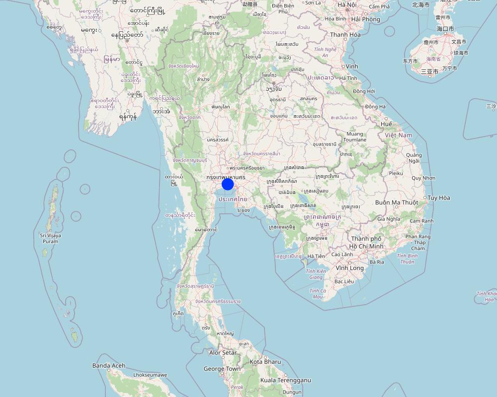
Map
×2.6 Date of implementation
Indicate year of implementation:
2007
If precise year is not known, indicate approximate date:
- 10-50 years ago
2.7 Introduction of the Technology
Specify how the Technology was introduced:
- through land users' innovation
- through projects/ external interventions
Comments (type of project, etc.):
The technology arises from land users’ innovation and is supported by external interventions and government agencies that acknowledge the value of technology to the community by providing resources, funding and supporting research and development.
3. Classification of the SLM Technology
3.1 Main purpose(s) of the Technology
- reduce, prevent, restore land degradation
- conserve ecosystem
- preserve/ improve biodiversity
- mitigate climate change and its impacts
- create beneficial social impact
3.2 Current land use type(s) where the Technology is applied
Land use mixed within the same land unit:
Yes
Specify mixed land use (crops/ grazing/ trees):
- Agroforestry

Forest/ woodlands
- Tree plantation, afforestation

Waterways, waterbodies, wetlands
- Swamps, wetlands
3.3 Has land use changed due to the implementation of the Technology?
Has land use changed due to the implementation of the Technology?
- No (Continue with question 3.4)
Forest/ woodlands
- (Semi-)natural forests/ woodlands
Waterways, waterbodies, wetlands
3.4 Water supply
Water supply for the land on which the Technology is applied:
- mixed rainfed-irrigated
3.5 SLM group to which the Technology belongs
- natural and semi-natural forest management
- agroforestry
3.6 SLM measures comprising the Technology

management measures
3.7 Main types of land degradation addressed by the Technology

soil erosion by water
- Wr: riverbank erosion

biological degradation
- Bq: quantity/ biomass decline
3.8 Prevention, reduction, or restoration of land degradation
Specify the goal of the Technology with regard to land degradation:
- restore/ rehabilitate severely degraded land
4. Technical specifications, implementation activities, inputs, and costs
4.1 Technical drawing of the Technology
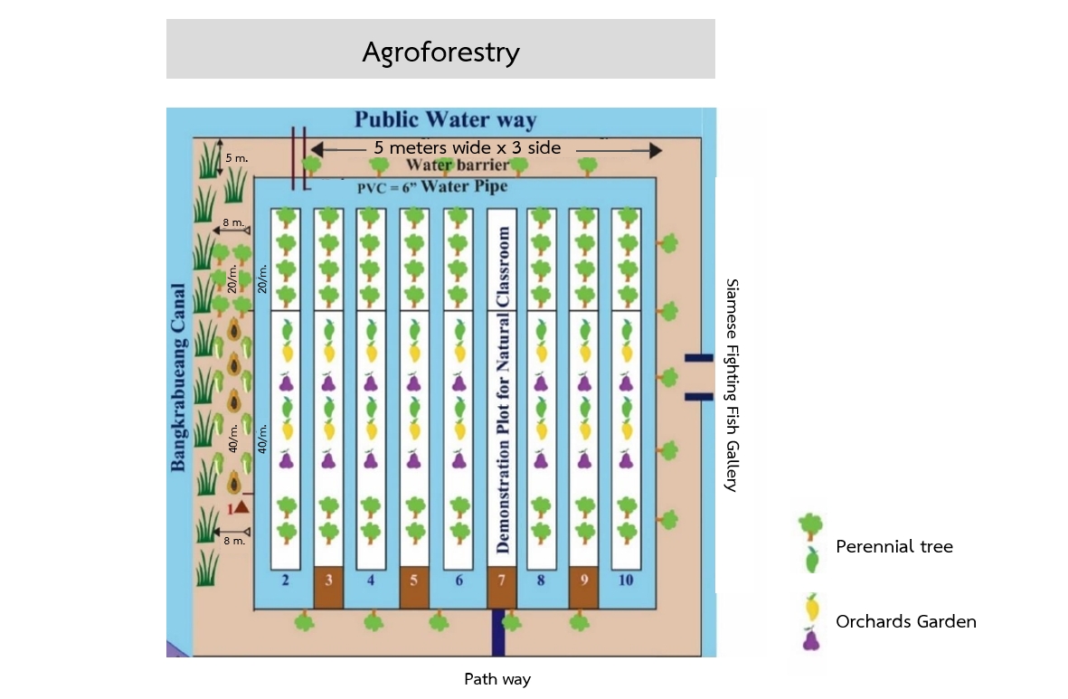
Technical specifications (related to technical drawing):
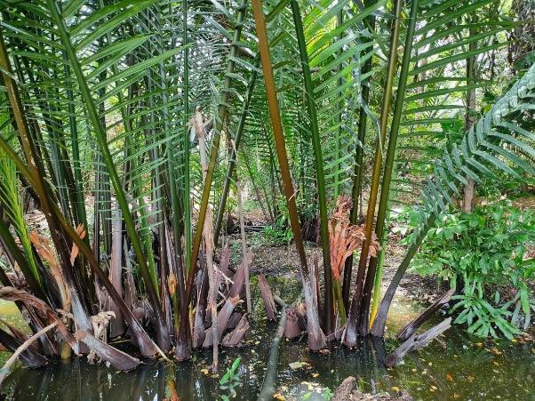
Tree planting in the brackish forest area is carried out in three levels:
Primary trees: These are native species in the area, primarily mangrove trees, which are highly tolerant to brackish and saline water conditions that persist for over six months of the year. Examples of planted species include Tin Pet Nam (Cerbera odollam Gaertn.) and Indian Tulip Tree (Thespesia populnea).
Secondary trees: These include edible trees, both fruit-bearing and leafy vegetables, which are resistant to brackish and saline conditions. Examples are Tamarind (Tamarindus indica) and Neem (Azadirachta indica).
Herbal plants: These are various herbs that grow well under the shade of larger trees. Examples include Betel Leaves (Piper sarmentosum), Nightshade (Solanum indicum) and Pandan Leaves (Pandanus amaryllifolius).
4.2 General information regarding the calculation of inputs and costs
Specify how costs and inputs were calculated:
- per Technology area
Indicate size and area unit:
2.56 ha
If using a local area unit, indicate conversion factor to one hectare (e.g. 1 ha = 2.47 acres): 1 ha =:
6.25 rai
Specify currency used for cost calculations:
- USD
Indicate average wage cost of hired labour per day:
8.82 USD
4.3 Establishment activities
| Activity | Timing (season) | |
|---|---|---|
| 1. | Main plants refer to local plants in the area, namely plants in mangrove forests which are tolerant to being brackish and salinity of natural water resources for more than 6 months per year. The plants grown are Cerbera odollam, Indian laurel, Bruguiera sexangul, Intsia bijuga, Thespesia populnea, cork tree and Copper pod. | |
| 2. | Secondary plants refer to edible plants for fruit trees and plants with edible leaves. These plants are tolerant to brackish conditions and salinity such as tamarind, neem, Cassod tree, Great morinda, Luna nut, Ardisia polycephala | |
| 3. | Medicinal plants thriving well under shade of big trees such as Piper Samentosum, Solanum incanum, Pandanus leaf, Cordyline fruticosa, Sea holly |
4.4 Costs and inputs needed for establishment
| Specify input | Unit | Quantity | Costs per Unit | Total costs per input | % of costs borne by land users | |
|---|---|---|---|---|---|---|
| Labour | Deepen the garden ditch in the area of 2.56 ha | Bed | 50.0 | 17.6 | 880.0 | 100.0 |
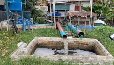
| Equipment | Water pump | Machine | 2.0 | 147.0 | 294.0 | 100.0 |
| Equipment | Compost | Tonne | 30.0 | 29.4 | 882.0 | 100.0 |
| Equipment | 15-15-15 chemical fertilizer | Sack | 20.0 | 29.4 | 588.0 | 100.0 |
| Equipment | Lime | Tonne | 10.0 | 88.2 | 882.0 | 100.0 |
| Equipment | 500 liter plastic bucked | BucKed | 5.0 | 58.8 | 294.0 | 100.0 |
| Equipment | Water salinity meter | Machine | 2.0 | 29.4 | 58.8 | 100.0 |
| Equipment | 8 inch PVC with the length of 3 meters | Piece | 3.0 | 29.4 | 88.2 | 100.0 |
| Plant material | Plant varieties including planting labor costs in the area of 2.56 ha | Tree | 10000.0 | 0.15 | 1500.0 | 100.0 |
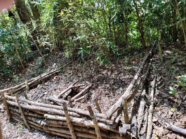
| Other | Materials used in building the nursery including labor costs | Square meters | 20.0 | 29.4 | 588.0 | 100.0 |
| Total costs for establishment of the Technology | 6055.0 | |||||
| Total costs for establishment of the Technology in USD | 6055.0 | |||||
Comments:
External organizations and government agencies contribute by offering essential financial and technical support to local communities.
4.5 Maintenance/ recurrent activities
| Activity | Timing/ frequency | |
|---|---|---|
| 1. | weed removal | |
| 2. | fertilizer application | |
| 3. | tillage | |
| 4. | planting for repairing and maintaining trees in the cultivation plot |
4.6 Costs and inputs needed for maintenance/ recurrent activities (per year)
| Specify input | Unit | Quantity | Costs per Unit | Total costs per input | % of costs borne by land users | |
|---|---|---|---|---|---|---|
| Labour | Management during planting and maintenance (1 year) | Force | 1.0 | 352.8 | 352.8 | 100.0 |
| Other | Electricity costs | USD | 12.0 | 14.7 | 176.4 | 100.0 |
| Total costs for maintenance of the Technology | 529.2 | |||||
| Total costs for maintenance of the Technology in USD | 529.2 | |||||
Comments:
External organizations and government agencies contribute by offering essential financial and technical support to local communities.
4.7 Most important factors affecting the costs
Describe the most determinate factors affecting the costs:
1. Labour cost
2. Agricultural materials costs
3. Construction materials costs
5. Natural and human environment
5.1 Climate
Annual rainfall
- < 250 mm
- 251-500 mm
- 501-750 mm
- 751-1,000 mm
- 1,001-1,500 mm
- 1,501-2,000 mm
- 2,001-3,000 mm
- 3,001-4,000 mm
- > 4,000 mm
Specify average annual rainfall (if known), in mm:
1545.00
Agro-climatic zone
- sub-humid
5.2 Topography
Slopes on average:
- flat (0-2%)
- gentle (3-5%)
- moderate (6-10%)
- rolling (11-15%)
- hilly (16-30%)
- steep (31-60%)
- very steep (>60%)
Landforms:
- plateau/plains
- ridges
- mountain slopes
- hill slopes
- footslopes
- valley floors
Altitudinal zone:
- 0-100 m a.s.l.
- 101-500 m a.s.l.
- 501-1,000 m a.s.l.
- 1,001-1,500 m a.s.l.
- 1,501-2,000 m a.s.l.
- 2,001-2,500 m a.s.l.
- 2,501-3,000 m a.s.l.
- 3,001-4,000 m a.s.l.
- > 4,000 m a.s.l.
Indicate if the Technology is specifically applied in:
- not relevant
5.3 Soils
Soil depth on average:
- very shallow (0-20 cm)
- shallow (21-50 cm)
- moderately deep (51-80 cm)
- deep (81-120 cm)
- very deep (> 120 cm)
Soil texture (topsoil):
- fine/ heavy (clay)
Soil texture (> 20 cm below surface):
- fine/ heavy (clay)
Topsoil organic matter:
- medium (1-3%)
If available, attach full soil description or specify the available information, e.g. soil type, soil PH/ acidity, Cation Exchange Capacity, nitrogen, salinity etc.
The soil is Samutprakarn soil series (Sm), soil series group 3. The parent material of soil is derived from marine sediments mixing with alluvial sediments. Soil reaction is moderately acidic to moderately alkaline (pH 6.6-8.0). The limitation factor of land-use is saline soil and be flooded by sea water.
5.4 Water availability and quality
Availability of surface water:
good
Water quality (untreated):
for agricultural use only (irrigation)
Water quality refers to:
surface water
Is water salinity a problem?
Yes
Specify:
land-use is flooded by sea water
Is flooding of the area occurring?
Yes
Regularity:
frequently
5.5 Biodiversity
Species diversity:
- high
Habitat diversity:
- high
Comments and further specifications on biodiversity:
The area features a unique geography and environment, located within a horseshoe-shaped bend of the Chao Phraya River, which forms a natural buffer between urban Bangkok and its surroundings. This distinctive setting fosters a diverse range of aquatic, riparian, and terrestrial ecosystems, supporting a rich array of plant and animal life. Additionally, the region encompasses various habitats, including mangroves and wetlands that serve as vital refuges for numerous bird species, fish, and amphibians. The forested areas, with their abundance of native tree species, provide essential shelter and food for many wildlife species.
5.6 Characteristics of land users applying the Technology
Sedentary or nomadic:
- Sedentary
Market orientation of production system:
- mixed (subsistence/ commercial)
Relative level of wealth:
- average
Individuals or groups:
- groups/ community
Level of mechanization:
- manual work
- mechanized/ motorized
Gender:
- men
Age of land users:
- middle-aged
- elderly
5.7 Average area of land used by land users applying the Technology
- < 0.5 ha
- 0.5-1 ha
- 1-2 ha
- 2-5 ha
- 5-15 ha
- 15-50 ha
- 50-100 ha
- 100-500 ha
- 500-1,000 ha
- 1,000-10,000 ha
- > 10,000 ha
Is this considered small-, medium- or large-scale (referring to local context)?
- medium-scale
5.8 Land ownership, land use rights, and water use rights
Land ownership:
- state
Land use rights:
- communal (organized)
Water use rights:
- open access (unorganized)
Are land use rights based on a traditional legal system?
Yes
5.9 Access to services and infrastructure
health:
- poor
- moderate
- good
education:
- poor
- moderate
- good
technical assistance:
- poor
- moderate
- good
employment (e.g. off-farm):
- poor
- moderate
- good
markets:
- poor
- moderate
- good
energy:
- poor
- moderate
- good
roads and transport:
- poor
- moderate
- good
drinking water and sanitation:
- poor
- moderate
- good
financial services:
- poor
- moderate
- good
6. Impacts and concluding statements
6.1 On-site impacts the Technology has shown
Ecological impacts
Biodiversity: vegetation, animals
plant diversity
Comments/ specify:
Planting trees in the ecosystem of brackish-water forests and aquatic animal culture have brought about a variety of plant varieties and animal species such as egret.
animal diversity
habitat diversity
6.2 Off-site impacts the Technology has shown
groundwater/ river pollution
Comments/ specify:
Plants can lower groundwater levels, reducing salinity and waste water problems.
6.3 Exposure and sensitivity of the Technology to gradual climate change and climate-related extremes/ disasters (as perceived by land users)
Gradual climate change
Gradual climate change
| Season | increase or decrease | How does the Technology cope with it? | |
|---|---|---|---|
| seasonal temperature | dry season | decrease | moderately |
6.4 Cost-benefit analysis
How do the benefits compare with the establishment costs (from land users’ perspective)?
Short-term returns:
slightly positive
Long-term returns:
positive
How do the benefits compare with the maintenance/ recurrent costs (from land users' perspective)?
Short-term returns:
neutral/ balanced
Long-term returns:
neutral/ balanced
6.5 Adoption of the Technology
- single cases/ experimental
6.6 Adaptation
Has the Technology been modified recently to adapt to changing conditions?
No
6.7 Strengths/ advantages/ opportunities of the Technology
| Strengths/ advantages/ opportunities in the land user’s view |
|---|
| This technology contributes to environmental preservation and mitigates the burden of annual land ownership taxes, thereby promoting sustainable land use. |
| Strengths/ advantages/ opportunities in the compiler’s or other key resource person’s view |
|---|
| The technology aids in preserving soil and water fertility, restoring the environment, and sustainably expanding forested areas within urban communities. |
| Incorporating native plants and maintaining natural habitats can enhance biodiversity. |
6.8 Weaknesses/ disadvantages/ risks of the Technology and ways of overcoming them
| Weaknesses/ disadvantages/ risks in the land user’s view | How can they be overcome? |
|---|---|
| The technology has a relatively low economic return. | Developing land use practices in agriculture, fisheries, livestock, and other sectors is crucial. |
| Weaknesses/ disadvantages/ risks in the compiler’s or other key resource person’s view | How can they be overcome? |
|---|---|
| The technology significantly impacts the environment, however, its importance is not fully recognized by the community. | It is essential to develop more diverse land use patterns in agriculture, environmental management, and the tourism industry to generate income and ensure sustainable land use. |
| Low adoption of people around the project plot. | Increase local engagement and interest by host workshops or information sessions to introduce the project, explain benefits, and address any concerns from locals. |
7. References and links
7.1 Methods/ sources of information
- field visits, field surveys
8
- interviews with land users
1
- interviews with SLM specialists/ experts
5
7.3 Links to relevant online information
Title/ description:
Sustainable soil management practices in Asia
URL:
https://e-library.ldd.go.th/library/Ebook/bib10906.pdf
Links and modules
Expand all Collapse allLinks
No links
Modules
No modules