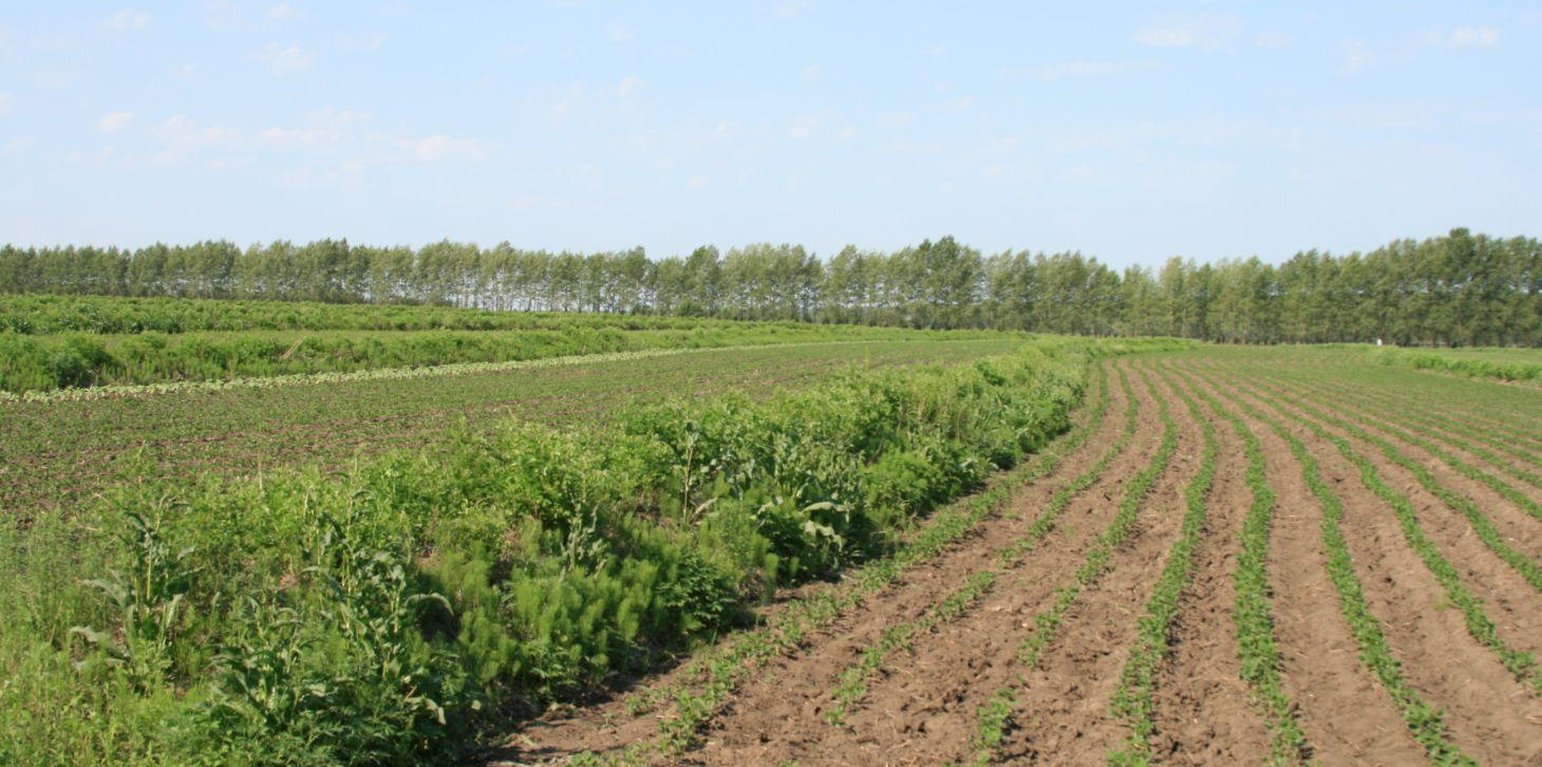
A three-year old, well established Shrubbery Buffer Strip With Bund(SBSWB) on a 5% slope (Meng Lingqin (Division of water and soil conservation, Songliao water resources commission, ministry of water reso))

Shrubbery buffer strip with bund (China)

Grass Buffer Strip

Descripción

Belts of shrub or grass, planted on the level bund which constructed along contour line in gentle slope farmland in the black soil region of Northeast China.

Shrubbery buffer strip with bund(SBSWB) is a traditional technology, it is introduced by the field staff about 60 years ago who worked in the farm in Heilongjiang province.This technology with low-cost, high effectives and easy to construct, which has been widely applied in all black soil region of Northeast China (Heilongjiang,Jilin,Liaoning,North of Inner Mongolia Autonomous Region).

Purpose of the Technology: The final purpose of these buffer strips is increasing crop production by decreasing soil loss. More specific objectives include: 1)protect the land from surface erosion by cutting slope length, increase infiltration and soil moisture; 2)to prevent soil loss of gentle slope farmland by allowing excess runoff to filter through but trapping sediment; 3) through the effect of tillage and water erosion between the strips, level bund lead to the formation of forward slope terraces over time, then developing into terrace final;4) creation of opportunities for additional income by harvesting fodder(grass) production and fruits(shrub).

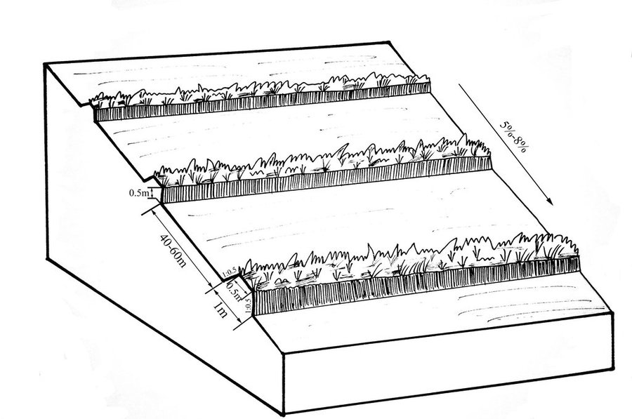
Establishment / maintenance activities and inputs: A construction is generally carried out in autumn of the year; plantation is made in spring of the next year. The construction in a man-machine integration mode is generally carried out step by step and from top to bottom along the contour line(s). The ladder-shaped cross section of a ridge is 0.3-0.5m in width (suitable width on the top), 0.5-0.6m in height, 1:1 or 1:0.5 in inner-side gradient and 1:0.5 in outer-side gradient.
In a construction, peel the surface soil with machine, with the peeling depth generally being 0.3m, which should be subject to soil layer depth; then haul the ridge construction plough (a kind of machine or device) with a tractor to build the ridges, consolidate the ridges through artificial slapping; Finally restore the surface soil to accomplish ridge construction. The tops of the constructed ridges should be maintained to be in a horizontal surface. The distance between two ridges in this region is generally stipulated to be 50 meters. The soil for ridge construction should be free from such sundries as gravels, tree roots and turfs.

Natural / human environment: Shrubbery buffer strip is found mainly in Northeast China, at altitudes between 700 and 1600 m. Climate there is cold in winters and cool in summers, with a monsoon moisture regime. In the area, the annual mean temperatures is from 2 to 8 °C, and the annual mean precipitation is from 500 to 1000 mm. Most of the farmland slopes are less than 7°but slope lengths mainly range from 200 to 1000m in this area.
Northeast China, the grain production base of China, or the bread basket of China, includes three provinces (Hei-long-jiang, Ji-lin, and Liao-ning) and the eastern part of the Inner Mongolian autonomous region. In 2009, 17.1% the China’s total grain production came from this region, which included 33.5%, 55.7% and 9.6% of corn, soybean, and rice, respectively. Approximately 118 million people live in this region. Grain produced per capita is over 1000 kg annually.

Lugar

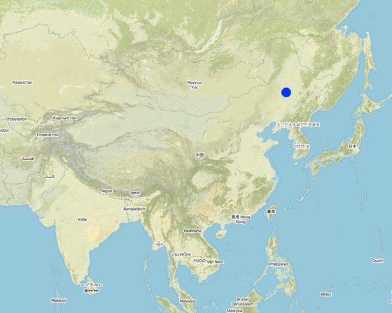
Lugar: Heilongjiang,Jilin,Liaoning,North of Inner Mongolia Autonomous Region, The black soil region of Northeast China, China

No. de sitios de Tecnología analizados:

Georreferencia de sitios seleccionados
  • 124.38667, 45.64222

Difusión de la Tecnología: distribuida parejamente sobre un área (approx. > 10,000 km2)

¿En un área de protección permanente?:

Fecha de la implementación: hace más de 50 años atrás (tradicional)

Tipo de introducción
Newly built Shrubbery Buffer Strip With Bund(SBSWB),the photo was taken in the first year (Meng Lingqin (Division of water and soil conservation, Songliao water resources commission, ministry of water reso))

Clasificación de la Tecnología

Propósito principal
  • mejorar la producción
  • reducir, prevenir, restaurar la degradación de la tierra
  • conservar el ecosistema
  • proteger una cuenca hidrográfica/ áreas corriente abajo – en combinación con otras Tecnologías
  • preservar/ mejorar biodiversidad
  • reducir el riesgo de desastres naturales
  • adaptarse al cambio climático/ extremos climáticos y sus impactos
  • mitigar cambio climático y sus impactos
  • crear impacto económico benéfico
  • crear impacto social benéfico
Uso de tierra

  • Tierras cultivadas
    • Cosecha anual: cereales - maíz, leguminosas y legumbres - soya, cultivos de raíces/ tubérculos - remolacha, rice
    Número de temporadas de cultivo por año: 1
Provisión de agua
  • de secano
  • mixta de secano – irrigada
  • totalmente irrigada

Propósito relacionado a la degradación de las tierras
  • prevenir la degradación de la tierra
  • reducir la degradación de la tierra
  • restaurar/ rehabilitar tierra severamente degradada
  • adaptarse a la degradación de la tierra
  • no aplica
La degradación considerada
  • erosión de suelos por agua - Wt: pérdida de capa arable/ erosión de la superficie , Wo: efectos de degradación fuera del sitio
  • erosión de suelos por viento - Et: pérdida de capa arable
Grupo MST
  • medida de pendiente transversal
Medidas MST
  • medidas vegetativas - V2: Pastos y plantas herbáceas perennes
  • medidas estructurales - S2: Taludes, bancos

Dibujo técnico

Especificaciones técnicas
The upper-base width, lower base width, height, slope ratio and spacing of a ridge are 0.5m, 1m, 0.5m, 1:0.5 and 40-60m respectively. A row spacing of the shrubs planted on the ridges should be 0.5m. Generally one row on each ridge is enough. About 80 shrubs are needed for every hectare; if herbaceous plants are planted, no special plantations are required.

Location: Chao Yang City. Liao Ning Province

Date: Nov 12,2012

Technical knowledge required for field staff / advisors: moderate (Field staff/agricultural advisor should have intermediate know-how level, because land user should be instructed by them)

Technical knowledge required for land users: low (The knowledge level of lander user is not required to be high, who just need(s) to follow the instructions from field staff/agricultural advisor)

Main technical functions: control of dispersed runoff: retain / trap, control of dispersed runoff: impede / retard, reduction of slope length, improvement of water quality, buffering / filtering water, sediment retention / trapping, sediment harvesting

Secondary technical functions: control of concentrated runoff: retain / trap, control of concentrated runoff: impede / retard, improvement of ground cover, improvement of topsoil structure (compaction), increase in organic matter, increase in nutrient availability (supply, recycling,…), increase of infiltration, increase / maintain water stored in soil, water harvesting / increase water supply, water spreading, increase of biomass (quantity), promotion of vegetation species and varieties (quality, eg palatable fodder), spatial arrangement and diversification of land use

Aligned: -contour
Vegetative material: F : fruit trees / shrubs
Number of plants per (ha): 200-600
Vertical interval between rows / strips / blocks (m): 5.644-8.466
Spacing between rows / strips / blocks (m): 40-60
Vertical interval within rows / strips / blocks (m): 0.5
Width within rows / strips / blocks (m): 0.5

Fruit trees / shrubs species: caragana, lespedeza, amorpha, daylily, Melilotus

Slope (which determines the spacing indicated above): 5-8%

Gradient along the rows / strips: 0%

Wall/ barrier
Vertical interval between structures (m): 2.09-5.55
Spacing between structures (m): 40-60
Height of bunds/banks/others (m): 0.3-0.5
Width of bunds/banks/others (m): 0.5-1
Length of bunds/banks/others (m): >100

Construction material (earth): The soil should be free from such sundries as gravels, tree roots and turfs.

Slope (which determines the spacing indicated above): 5-8%

Lateral gradient along the structure: 0%
Author: Zhao Mei, Beijing Normal University, Beijing, China

Establecimiento/ mantenimiento: actividades, insumos y costos

Cálculo de insumos y costos
  • Los costos se calculan:
  • Moneda usada para calcular costos: RMB
  • Tasa de cambio (a USD): 1 USD = 6.25 RMB
  • Costo promedio por día del sueldo de la mano de obra contratada: 9.25
Factores más determinantes que afectan los costos
The most determinate fators affecting the cost is labour
Actividades de establecimiento
  1. Plant shrubbery (Momento/ frequencia: autumn)
  2. Layout of contour and the line of SBSWB with the leveling (Momento/ frequencia: autumn)
  3. Build the ridge (Momento/ frequencia: autumn)
Insumos y costos para establecimiento
Especifique insumo Unidad Cantidad Costos por unidad (RMB) Costos totales por insumo (RMB) % de los costos cubiertos por los usuarios de las tierras
Mano de obra
Layout of contour Person/day 3,0 16,0 48,0
Build ridge Person/day 36,0 9,6 345,6
Equipo
Machine use hours/day 1,0 80,0 80,0
tools day 1,0 8,0 8,0
Material para plantas
Seedling Plant shrubbery ha 600,0 0,016 9,6
Costos totales para establecer la Tecnología 491.2
Costos totales para establecer la Tecnología en USD 78.59
Actividades de mantenimiento
  1. The farmers will actively protect the Bund in their land. Don't need money. (Momento/ frequencia: autumn)
  2. The farmers will actively protect the Bund in their land. Don't need money. (Momento/ frequencia: autumn)

Entorno natural

Promedio anual de lluvia
  • < 250 mm
  • 251-500 mm
  • 501-750 mm
  • 751-1,000 mm
  • 1,001-1,500 mm
  • 1,501-2,000 mm
  • 2,001-3,000 mm
  • 3,001-4,000 mm
  • > 4,000 mm
Zona agroclimática
  • húmeda
  • Sub-húmeda
  • semi-árida
  • árida
Especificaciones sobre el clima
Thermal climate class: temperate

Thermal climate class: boreal
Pendiente
  • plana (0-2 %)
  • ligera (3-5%)
  • moderada (6-10%)
  • ondulada (11-15%)
  • accidentada (16-30%)
  • empinada (31-60%)
  • muy empinada (>60%)
Formaciones telúricas
  • meseta/ planicies
  • cordilleras
  • laderas montañosas
  • laderas de cerro
  • pies de monte
  • fondo del valle
Altura
  • 0-100 m s.n.m.
  • 101-500 m s.n.m.
  • 501-1,000 m s.n.m
  • 1,001-1,500 m s.n.m
  • 1,501-2,000 m s.n.m
  • 2,001-2,500 m s.n.m
  • 2,501-3,000 m s.n.m
  • 3,001-4,000 m s.n.m
  • > 4,000 m s.n.m
La Tecnología se aplica en
  • situaciones convexas
  • situaciones cóncavas
  • no relevante
Profundidad promedio del suelo
  • muy superficial (0-20 cm)
  • superficial (21-50 cm)
  • moderadamente profunda (51-80 cm)
  • profunda (81-120 cm)
  • muy profunda (>120 cm)
Textura del suelo (capa arable)
  • áspera/ ligera (arenosa)
  • mediana (limosa)
  • fina/ pesada (arcilla)
Textura del suelo (> 20 cm debajo de la superficie)
  • áspera/ ligera (arenosa)
  • mediana (limosa)
  • fina/ pesada (arcilla)
Materia orgánica de capa arable
  • elevada (>3%)
  • media (1-3%)
  • baja (<1%)
Agua subterránea
  • en superficie
  • < 5 m
  • 5-50 m
  • > 50 m
Disponibilidad de aguas superficiales
  • excesiva
  • bueno
  • mediana
  • pobre/ ninguna
Calidad de agua (sin tratar)
  • agua potable de buena calidad
  • agua potable de mala calidad (requiere tratamiento)
  • solo para uso agrícola (irrigación)
  • inutilizable
La calidad de agua se refiere a:
¿La salinidad del agua es un problema?
  • No

Incidencia de inundaciones
  • No
Diversidad de especies
  • elevada
  • mediana
  • baja
Diversidad de hábitats
  • elevada
  • mediana
  • baja

Las características de los usuarios de la tierra que aplican la Tecnología

Orientación del mercado
  • subsistencia (autoprovisionamiento)
  • mixta (subsistencia/ comercial)
  • comercial/ mercado
Ingresos no agrarios
  • menos del 10% de todos los ingresos
  • 10-50% de todo el ingreso
  • > 50% de todo el ingreso
Nivel relativo de riqueza
  • muy pobre
  • pobre
  • promedio
  • rico
  • muy rico
Nivel de mecanización
  • trabajo manual
  • tracción animal
  • mecanizado/motorizado
Sedentario o nómada
  • Sedentario
  • Semi-nómada
  • Nómada
Individuos o grupos
  • individual/ doméstico
  • grupos/ comunal
  • cooperativa
  • empleado (compañía, gobierno)
Género
  • mujeres
  • hombres
Edad
  • niños
  • jóvenes
  • personas de mediana edad
  • ancianos
Área usada por hogar
  • < 0.5 ha
  • 0.5-1 ha
  • 1-2 ha
  • 2-5 ha
  • 5-15 ha
  • 15-50 ha
  • 50-100 ha
  • 100-500 ha
  • 500-1,000 ha
  • 1,000-10,000 ha
  • > 10,000 ha
Escala
  • pequeña escala
  • escala mediana
  • gran escala
Tenencia de tierra
  • estado
  • compañía
  • comunitaria/ aldea
  • grupal
  • individual, sin título
  • individual, con título
Derechos de uso de tierra
  • acceso abierto (no organizado)
  • comunitarios (organizado)
  • arrendamiento
  • individual
Derechos de uso de agua
  • acceso abierto (no organizado)
  • comunitarios (organizado)
  • arrendamiento
  • individual
Acceso a servicios e infraestructura
salud

pobre
x
bueno
educación

pobre
x
bueno
asistencia técnica

pobre
x
bueno
empleo (ej. fuera de la granja)

pobre
x
bueno
mercados

pobre
x
bueno
energía

pobre
x
bueno
caminos y transporte

pobre
x
bueno
agua potable y saneamiento

pobre
x
bueno
servicios financieros

pobre
x
bueno

Impacto

Impactos socioeconómicos
Producción de cultivo
disminuyó
x
incrementó

producción de forraje
disminuyó
x
incrementó

calidad de forraje
disminuyó
x
incrementó

producción animal
disminuyó
x
incrementó

producción de madera
disminuyó
x
incrementó

diversidad de producto
disminuyó
x
incrementó

área de producción (nuevas tierras bajo cultivo/ en uso)
disminuyó
x
incrementó

manejo de tierras
obstaculizado
x
simplificado

generación de energía (ej. hidro, bio)
disminuyó
x
incrementó

disponibilidad de agua potable
disminuyó
x
incrementó

disponibilidad de agua para ganado
disminuyó
x
incrementó

calidad de agua para ganado
disminuyó
x
incrementó

disponibilidad de agua para irrigar
disminuyó
x
incrementó

calidad de agua para irrigar
disminuyó
x
incrementó

demanda de agua para irrigar
incrementó
x
disminuyó

gastos en insumos agrícolas
incrementó
x
disminuyó

ingreso agrario
disminuyó
x
incrementó

diversidad de fuentes de ingreso
disminuyó
x
incrementó

disparidades económicas
incrementó
x
disminuyó

carga de trabajo
incrementó
x
disminuyó

Impactos socioculturales
oportunidades culturales (ej. espirituales, estéticas, otras)
disminuyó
x
mejoró

oportunidades recreativas
disminuyó
x
mejoró

instituciones comunitarias
se debilitaron
x
se fortalecieron

instituciones nacionales
se debilitaron
x
se fortalecieron

mitigación de conflicto
empeoró
x
mejoró

Livelihoods and human well-being
reduced
x
improved

Impactos ecológicos
cantidad de agua
disminuyó
x
incrementó

calidad de agua
disminuyó
x
incrementó

cosecha/recolección de agua (escurrimiento, rocío, nieve, etc.)
disminuyó
x
mejoró

escurrimiento superficial
incrementó
x
disminuyó

drenaje de agua en exceso
disminuyó
x
mejoró

nivel freático/ acuífero
disminuyó
x
recargó

evaporación
incrementó
x
disminuyó

humedad del suelo
disminuyó
x
incrementó

cubierta del suelo
disminuyó
x
mejoró

pérdida de suelo
incrementó
x
disminuyó

encostramiento/ sellado de suelo
incrementó
x
disminuyó

compactación de suelo
incrementó
x
disminuyó

ciclo/ recarga de nutrientes
disminuyó
x
incrementó

salinidad
incrementó
x
disminuyó

materia orgánica debajo del suelo C
disminuyó
x
incrementó

biomasa/ sobre suelo C
disminuyó
x
incrementó

diversidad vegetal
disminuyó
x
incrementó

diversidad animal
disminuyó
x
incrementó

especies benéficas (depredadores, gusanos de tierra, polinizadores)
disminuyó
x
incrementó

emisión de carbono y gases de invernadero
incrementó
x
disminuyó

velocidad de viento
incrementó
x
disminuyó

Impactos fuera del sitio
disponibilidad de agua (aguas subterráneas, manantiales)
disminuyó
x
incrementó

corriente confiable y estable fluye en estación seca (inc. caudales bajos)
disminuyó
x
incrementó

inundaciones río abajo (no deseadas)
incrementó
x
disminuyó

colmatación río abajo
incrementó
x
disminuyó

contaminación de aguas subterráneas/ de ríos
incrementó
x
disminuyó

capacidad de amortiguación/ filtrado (por suelo, vegetación, humedales)
disminuyó
x
mejoró

sedimentos transportados por el viento
incrementó
x
disminuyó

daño a campos de vecinos
incrementó
x
disminuyó

daños a infraestructura pública / privada
incrementó
x
disminuyó

Análisis costo-beneficio

Beneficios comparados con los costos de establecimiento
Ingresos a corto plazo:
muy negativo
x
muy positivo

Ingresos a largo plazo
muy negativo
x
muy positivo

Beneficios comparados con costos de mantenimiento
Ingresos a corto plazo:
muy negativo
x
muy positivo

Ingresos a largo plazo
muy negativo
x
muy positivo

Although Certain quantity of land will be occupied and grain output will be affected in SBSWS during the early period of a construction, in the long run, SBSWS can prevent the loss of the most fertile surface soil, in addition, with the ever increased quantity of the sediment intercepted by SBSWS and as the heights of the vegetational belts increase year by year, the slope croplands will become bench terraces, and the grain output will be increased.

Cambio climático

Cambio climático gradual
temperatura anual incrementó

nada bien
x
muy bien
Extremos (desastres) relacionados al clima
tormenta de lluvia local

nada bien
x
muy bien
tormenta de viento

nada bien
x
muy bien
sequía

nada bien
x
muy bien
inundación general (río)

nada bien
x
muy bien
Otras consecuencias relacionadas al clima
periodo reducido de crecimiento

nada bien
x
muy bien

Adopción y adaptación

Porcentaje de usuarios de la tierra que adoptaron la Tecnología
  • casos individuales / experimentales
  • 1-10%
  • 11-50%
  • > 50%
De todos quienes adoptaron la Tecnología, ¿cuántos lo hicieron sin recibir incentivos/ pagos materiales?
  • 0-10%
  • 11-50%
  • 51-90%
  • 91-100%
Número de hogares y/ o área cubierta
NA
¿La tecnología fue modificada recientemente para adaptarse a las condiciones cambiantes?
  • No
¿A qué condiciones cambiantes?
  • cambios climáticos / extremos
  • mercados cambiantes
  • disponibilidad de mano de obra (ej. debido a migración)

Conclusiones y lecciones aprendidas

Fortalezas: perspectiva del usuario de tierras
  • Convenient for construction

    How can they be sustained / enhanced? Popularization carried on
Fortalezas: punto de vista del compilador o de otra persona recurso clave
  • Gradual formation of the slope-type terraces, which can be developed into bench terraces many years later

    How can they be sustained / enhanced? Increase of ridge height year by year
  • Intercepting the sediments carried by runoffs, preventing water and soil loss of the arable lands on the gentle slopes

    How can they be sustained / enhanced? In combination with other water and soil conservation measures during operation, such as no-tillage and drainage ditches;
  • increase of infiltration

    How can they be sustained / enhanced? Chopping down branches at regular intervals to guarantee that the plants on the ridges will not enter into rivary with the crops over water and sunlight;
Debilidades/ desventajas/ riesgos: perspectiva del usuario de tierrascómo sobreponerse
  • The ridges occupy land and reduce arable area government support
Debilidades/ desventajas/ riesgos: punto de vista del compilador o de otra persona recurso clavecómo sobreponerse
  • Reduction of arable lands brings about low enthusiasm of the peasants Conflict between the arable lands and the immediate interests of the peasants. Popularization of water and soil preservation knowledge should be strangthened to make the presants realize that although the immediate interests will be hurt, the long-term interests will increase.

Referencias

Compilador
  • Mei Zhao
Editors
Revisado por
  • David Streiff
  • Alexandra Gavilano
Fecha de la implementación: 25 de abril de 2012
Últimas actualización: 14 de marzo de 2019
Personas de referencia
Descripción completa en la base de datos de WOCAT
Datos MST vinculados
La documentación fue facilitada por
Institución Proyecto
Referencias claves
  • Title:Techniques standard for comprehensive control of soil erosion in the black soil region Author:Shen bo; Meng lingqinYears:2009: internal materials
This work is licensed under Creative Commons Attribution-NonCommercial-ShareaAlike 4.0 International