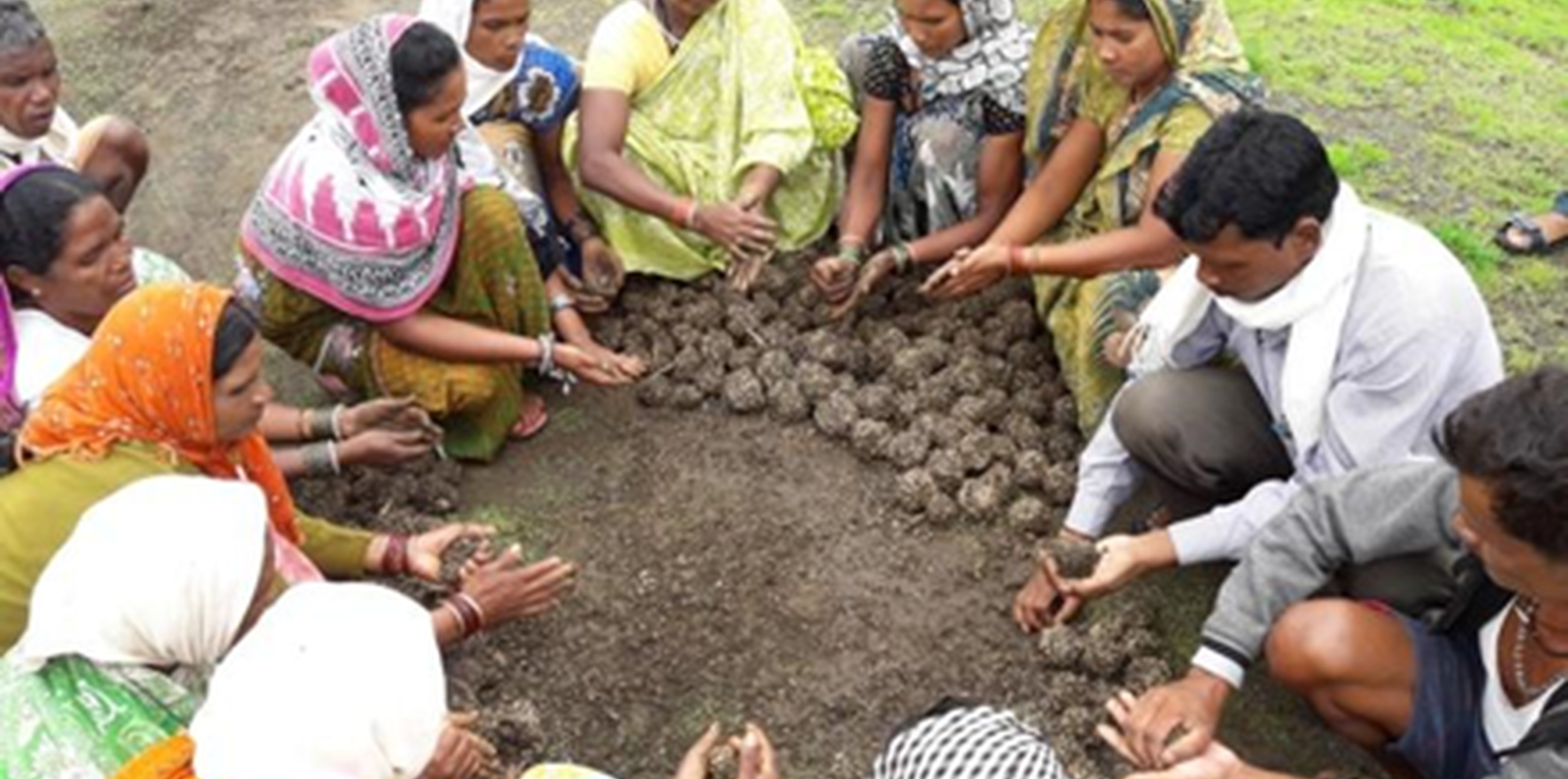
Women belonging to a village institution prepare indigenous grass seed balls (FES)

Community Based Soil Rehabilitation for Grassland on Common Lands after Eradication of the Invasive Lantana Camara (India)

Descripción

Community-based soil rehabilitation by eradicating the invasive plant Lantana Camara using the 'cut rootstock' method (refer to WOCAT technology 6660) is an effective, cost-efficient, and sustainable approach to restoring grasslands on common lands in the Mandla District of Madhya Pradesh. The three-tier institutional structure used in this eradication process involved the formation of informal women groups at the hamlet level (village organisational structure), the Village Environment Committee (VEC) at the village level, and an Executive Committee at the cluster level (higher organisational structure) so to ensure community involvement and ownership.

Community-based soil rehabilitation after the eradication of the invasive plant species, Lantana Camara, is an effective technique for restoring grasslands on common lands that had earlier been invaded by this species. The invasion of Lantana Camara can have significant negative impacts on the ecosystem, reducing the diversity of plant life and disrupting the local communities' use of common lands for grazing, for agriculture, and for collecting non-timber forest products.

To address these issues, a three-tier institutional structure is being used by the project-implementing organization Foundation for Ecological Security (FES). This structure includes the formation of informal women groups at the hamlet level, the Village Environment Committee (VEC) at the village level, and an executive committee at the cluster level. The VEC prepares proposals on common issues and plans with budgets that are presented to the executive committee, which is made up of a mix of individuals, with 50% of the seats reserved for women.

The first step in the process is for the village executive committee to take the Gram Sabha (Village Governing Body) into confidence and prepare bylaws for the restoration and conservation of the Lantana-eradicated site. These bylaws are regularly discussed in the village institution meeting to refresh the memory of the community and different stakeholders on how to properly conserve the site. Local resource persons facilitate the implementation of work.

One of the major works undertaken by these communities in the Mandla District is the soil rehabilitation from Lantana Camara for grassland restoration on common lands. The uprooting of Lantana is a tricky process, and improper methods can result in an even more forceful recurrence of the species. Therefore, the "cut rootstock" method is used, which involves cutting the root of the plant three inches below the ground and lifting the bush upside down to prevent it from gaining ground. This method is done between July and September before fruiting to avoid seed fall, which can cause recurrence for up to three years, also this is the time when the soil has enough moisture thus softness to uproot the Lantana plants.

The Cut Rootstock (CRS) method to control the spread of Lantana Camara is cost-effective and sustainable as it does not require the use of chemical herbicides or heavy machinery. In addition to using the CRS method, perching trees are located, and saplings are removed from under their canopies and along the nearby surface runoff zone. Regular monitoring and follow-up actions may be necessary to ensure the long-term success of this method in controlling the spread of Lantana Camara.

To prevent a recurrence, measures such as mopping for three years continuously, planting and seed sowing in areas where rootstocks seem to be less, and grass seed sowing are executed. The community institution ensures the collection of indigenous grass species, which are made into seed balls and sown before the advent of monsoon. These grass seeds germinate and grow in the rainy season, reducing the suitable environment for Lantana seed germination. Revegetation measures involve selecting and planting grazing hardy, fire hardy, and water hardy tree species such as bamboo, Khameer, Java Plum, Karanj (Pongame oil tree), Aonla, Harra, and other non-timber forest product-producing tree species. These plants are selected to create a three-tiered forest and sustainably provide food, fuel wood, and fodder. Once established, they do not allow Lantana to grow.

Biomass assessment is undertaken every year to assess the improvement in the status of the biomass in the plot, and the findings are shared with the community to motivate them to follow the rules and regulations formulated by the village institution. Cut and carry practices are allowed from the second year, but open grazing is prohibited, and Lantana eradication from nearby areas is required while cutting the grass. This helps to bring Lantana under control while sustainably utilizing the grass resources.

This initiative has ensured access to common lands for the local communities, access to fodder and green grass for livestock and the emergence of biodiversity in the area. This initiative is well recognised by Government institutions and policy makers.

Lugar

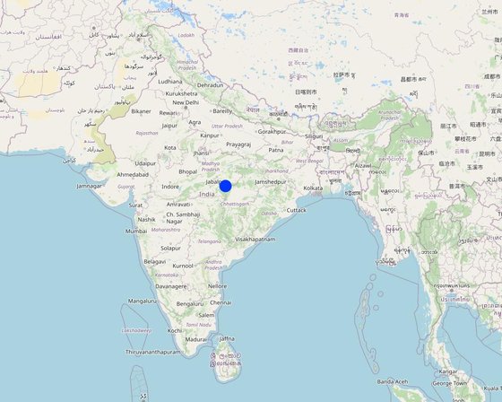
Lugar: Village: Changaniya, Block- Bichhiya, Mandla, Madhya Pradesh, India

No. de sitios de Tecnología analizados: 10-100 sitios

Georreferencia de sitios seleccionados
  • 80.71107, 22.45255

Difusión de la Tecnología: aplicada en puntos específicos/ concentrada en un área pequeña

¿En un área de protección permanente?: No

Fecha de la implementación: 2016

Tipo de introducción
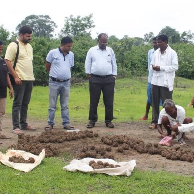
Preparation of seedballs of indigenous grassland seeds
Restored Grassland after eradication of Lantana Camara

Clasificación de la Tecnología

Propósito principal
  • mejorar la producción
  • reducir, prevenir, restaurar la degradación de la tierra
  • conservar el ecosistema
  • proteger una cuenca hidrográfica/ áreas corriente abajo – en combinación con otras Tecnologías
  • preservar/ mejorar biodiversidad
  • reducir el riesgo de desastres naturales
  • adaptarse al cambio climático/ extremos climáticos y sus impactos
  • mitigar cambio climático y sus impactos
  • crear impacto económico benéfico
  • crear impacto social benéfico
Uso de tierra
Mezcla de tipos de uso de tierras dentro de la misma unidad de tierras: Sí - Silvo-pastoralismo

  • Tierra de pastoreo
    • Pastoralismo trashumante
    • Cortar y llevar/ cero pastoreo
    • Pastoreo mejorado
    • Eradication of Lantana and restoring the grasslands
    Tipo de animal: búfalos, ganado - lechero, cabras
    ¿Se practica el manejo integrado de cultivos - ganado? No
    Productos y servicios: economic security, investment prestige
      EspeciesCount
      búfalosn.d.
      ganado - lecheron.d.
      cabrasn.d.
    • Bosques
      • Bosques/ zonas boscosas (semi) naturales. Manejo: Eliminación de madera muerta/ de poda, Uso de productos forestales no madereros
      Tree types (deciduo): n.d.
      Productos y servicios: Leña, Frutos y nueces, Pastoreo/ ramoneo, Conservación/ Protección de la naturaleza

    Provisión de agua
    • de secano
    • mixta de secano – irrigada
    • totalmente irrigada

    Propósito relacionado a la degradación de las tierras
    • prevenir la degradación de la tierra
    • reducir la degradación de la tierra
    • restaurar/ rehabilitar tierra severamente degradada
    • adaptarse a la degradación de la tierra
    • no aplica
    La degradación considerada
    • degradación biológica - Bc: reducción de la cobertura vegetal del suelo , Bq: reducción de la cantidad/ biomasa, Bf: efectos nocivos de los fuegos, Bs: reducción en la calidad y composición/ diversidad de las especies, Bl: pérdida de la vida del suelo
    Grupo MST
    • veda de zona (detener uso, apoyar la restauración)
    • pastoralismo y manejo de tierras de pastoreo
    • cobertura de suelo/ vegetal mejorada
    Medidas MST
    • medidas vegetativas - V4:reemplazo o eliminación de especies extrañas/ invasoras
    • medidas de manejo - M1: Cambio de tipo de uso de la tierra , M5: Control/ cambio de composición de las especies

    Dibujo técnico

    Especificaciones técnicas
    Drawing of this technology does not require as there no technical structure being build as part of the intervention. The images indicated a rehabilitated field after the eradication of Lantana.

    Establecimiento/ mantenimiento: actividades, insumos y costos

    Cálculo de insumos y costos
    • Los costos se calculan: por área de Tecnología (unidad de tamaño y área: 1; factor de conversión a una hectárea: 1 ha = ha)
    • Moneda usada para calcular costos: INR (2023 April)
    • Tasa de cambio (a USD): 1 USD = 82.12 INR (2023 April)
    • Costo promedio por día del sueldo de la mano de obra contratada: 204
    Factores más determinantes que afectan los costos
    The density of lantana in the field is categorized into 3: more than 1500 bushes are considered high density, and between 500-1500 are considered moderately dense, while less than 500 is known as lowly dense. Such categories have a decicive impact on the costs.
    Actividades de establecimiento
    1. Removal of lantana (Momento/ frequencia: September-October (After Monsoon))
    2. Preparation of seeds for sowing (Momento/ frequencia: Before the onset of Monsoon)
    3. Sowing of seeds (Momento/ frequencia: Just before the onset of monsoon or during the monsoon (June/July))
    Insumos y costos para establecimiento (per 1)
    Especifique insumo Unidad Cantidad Costos por unidad (INR (2023 April)) Costos totales por insumo (INR (2023 April)) % de los costos cubiertos por los usuarios de las tierras
    Mano de obra
    Removal of lantana ha 1,0 7229,0 7229,0 20,0
    Land preparation for plantation Person day 1,0 200,0 200,0 100,0
    Sowing of seeds Person days 2,0 200,0 400,0 100,0
    Equipo
    Land preparation for plantation ha 1,0 1000,0 1000,0 50,0
    Material para plantas
    Seeds or planting material Ha 1,0 1000,0 1000,0 50,0
    Cow dung and compost material Ha 1,0 2500,0 2500,0 100,0
    Costos totales para establecer la Tecnología 12'329.0
    Costos totales para establecer la Tecnología en USD 150.13
    Actividades de mantenimiento
    1. Regular monitoring of the plantation area (Momento/ frequencia: July to November)
    2. Application of compost (Momento/ frequencia: June-July)
    Insumos y costos de mantenimiento (per 1)
    Especifique insumo Unidad Cantidad Costos por unidad (INR (2023 April)) Costos totales por insumo (INR (2023 April)) % de los costos cubiertos por los usuarios de las tierras
    Mano de obra
    Monitoring of plantation area Person days 12,0 200,0 2400,0 100,0
    Material para plantas
    Application of compost Ha 1,0 2000,0 2000,0 100,0
    Indique los costos totales para mantenecer la Tecnología 4'400.0
    Costos totales para mantener la Tecnología en USD 53.58

    Entorno natural

    Promedio anual de lluvia
    • < 250 mm
    • 251-500 mm
    • 501-750 mm
    • 751-1,000 mm
    • 1,001-1,500 mm
    • 1,501-2,000 mm
    • 2,001-3,000 mm
    • 3,001-4,000 mm
    • > 4,000 mm
    Zona agroclimática
    • húmeda
    • Sub-húmeda
    • semi-árida
    • árida
    Especificaciones sobre el clima
    Promedio anual de lluvia en mm:1427.7
    Monsoon season is June-September which has the majority of the rainfall
    Nombre de la estación meteorológica: District at glance report of Ministry of Water Resources, Central Groundwater Board, North Central Region BHOPAL, 2013
    The National Bureau of Soil Survey & Land Use Planning (NBSS&LUP) developed twenty agroecological zones based on the growing period as an integrated criterion of adequate rainfall and soil groups. It delineated boundaries adjusted to District boundaries with a minimal number of regions. Mandla District of Madhya Pradesh lies in a hot subhumid ecoregion with red and black soil.

    Precepitation - 1000–1500mm; Potential Evapotranspiration -1300–1500 mm; Lenght of Growing Period-150–180days
    Pendiente
    • plana (0-2 %)
    • ligera (3-5%)
    • moderada (6-10%)
    • ondulada (11-15%)
    • accidentada (16-30%)
    • empinada (31-60%)
    • muy empinada (>60%)
    Formaciones telúricas
    • meseta/ planicies
    • cordilleras
    • laderas montañosas
    • laderas de cerro
    • pies de monte
    • fondo del valle
    Altura
    • 0-100 m s.n.m.
    • 101-500 m s.n.m.
    • 501-1,000 m s.n.m
    • 1,001-1,500 m s.n.m
    • 1,501-2,000 m s.n.m
    • 2,001-2,500 m s.n.m
    • 2,501-3,000 m s.n.m
    • 3,001-4,000 m s.n.m
    • > 4,000 m s.n.m
    La Tecnología se aplica en
    • situaciones convexas
    • situaciones cóncavas
    • no relevante
    Profundidad promedio del suelo
    • muy superficial (0-20 cm)
    • superficial (21-50 cm)
    • moderadamente profunda (51-80 cm)
    • profunda (81-120 cm)
    • muy profunda (>120 cm)
    Textura del suelo (capa arable)
    • áspera/ ligera (arenosa)
    • mediana (limosa)
    • fina/ pesada (arcilla)
    Textura del suelo (> 20 cm debajo de la superficie)
    • áspera/ ligera (arenosa)
    • mediana (limosa)
    • fina/ pesada (arcilla)
    Materia orgánica de capa arable
    • elevada (>3%)
    • media (1-3%)
    • baja (<1%)
    Agua subterránea
    • en superficie
    • < 5 m
    • 5-50 m
    • > 50 m
    Disponibilidad de aguas superficiales
    • excesiva
    • bueno
    • mediana
    • pobre/ ninguna
    Calidad de agua (sin tratar)
    • agua potable de buena calidad
    • agua potable de mala calidad (requiere tratamiento)
    • solo para uso agrícola (irrigación)
    • inutilizable
    La calidad de agua se refiere a: agua subterránea y superficial
    ¿La salinidad del agua es un problema?
    • No

    Incidencia de inundaciones
    • No
    Diversidad de especies
    • elevada
    • mediana
    • baja
    Diversidad de hábitats
    • elevada
    • mediana
    • baja

    Las características de los usuarios de la tierra que aplican la Tecnología

    Orientación del mercado
    • subsistencia (autoprovisionamiento)
    • mixta (subsistencia/ comercial)
    • comercial/ mercado
    Ingresos no agrarios
    • menos del 10% de todos los ingresos
    • 10-50% de todo el ingreso
    • > 50% de todo el ingreso
    Nivel relativo de riqueza
    • muy pobre
    • pobre
    • promedio
    • rico
    • muy rico
    Nivel de mecanización
    • trabajo manual
    • tracción animal
    • mecanizado/motorizado
    Sedentario o nómada
    • Sedentario
    • Semi-nómada
    • Nómada
    Individuos o grupos
    • individual/ doméstico
    • grupos/ comunal
    • cooperativa
    • empleado (compañía, gobierno)
    Género
    • mujeres
    • hombres
    Edad
    • niños
    • jóvenes
    • personas de mediana edad
    • ancianos
    Área usada por hogar
    • < 0.5 ha
    • 0.5-1 ha
    • 1-2 ha
    • 2-5 ha
    • 5-15 ha
    • 15-50 ha
    • 50-100 ha
    • 100-500 ha
    • 500-1,000 ha
    • 1,000-10,000 ha
    • > 10,000 ha
    Escala
    • pequeña escala
    • escala mediana
    • gran escala
    Tenencia de tierra
    • estado
    • compañía
    • comunitaria/ aldea
    • grupal
    • individual, sin título
    • individual, con título
    Derechos de uso de tierra
    • acceso abierto (no organizado)
    • comunitarios (organizado)
    • arrendamiento
    • individual
    Derechos de uso de agua
    • acceso abierto (no organizado)
    • comunitarios (organizado)
    • arrendamiento
    • individual
    Acceso a servicios e infraestructura
    salud

    pobre
    bueno
    educación

    pobre
    bueno
    asistencia técnica

    pobre
    bueno
    empleo (ej. fuera de la granja)

    pobre
    bueno
    mercados

    pobre
    bueno
    energía

    pobre
    bueno
    caminos y transporte

    pobre
    bueno
    agua potable y saneamiento

    pobre
    bueno
    servicios financieros

    pobre
    bueno
    Comentarios

    Parts of the District suffer from poor road and transportation network

    Impacto

    Impactos socioeconómicos
    producción de forraje
    disminuyó
    incrementó


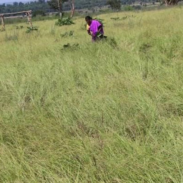
    From the second year onwards after the restoration of the grassland, the grass can be made available for cattle through a cut and feed method. This involves cutting the grass in a controlled manner and providing it to the cattle as feed. By using this method, the grass can be harvested at its optimum stage of growth, and the cattle can be provided with high-quality feed throughout the year. Additionally, this method allows for better utilization of the grass, minimizing any waste or overgrazing of the grassland.

    producción animal
    disminuyó
    incrementó


    Availability of fodder to villages from common lands

    manejo de tierras
    obstaculizado
    simplificado


    Lantana Camara is a problematic weed that has many disadvantages. It can reduce biodiversity, decrease soil fertility, and impede the growth of other plant species. Moreover, it can also be toxic to livestock and humans if ingested.

    The restoration of grasslands and the eradication of lantana can help in land management. By removing the weed, the growth of other plant species can be promoted, leading to increased biodiversity and improved soil fertility. The removal of lantana can also help to reduce the risk of wildfires, as it is known to be a highly flammable plant.

    Restoration of grassland and regulating the use of indigenous grasses as fodder for cattle
    None
    None


    The restoration of grassland and regulation of indigenous grasses for cattle fodder can benefit villagers both socially and economically. Socially, it promotes community involvement and ownership of the land, while promoting sustainable land use practices benefit the environment and community. Economically, the restoration provides a sustainable source of income through the sale of milk and meat products, and eco-tourism can help to boost the local economy.

    Impactos socioculturales
    Impactos ecológicos
    cubierta del suelo
    disminuyó
    mejoró


    Lantana is known to release allelopathic compounds into the soil, which can inhibit the growth of other plant species. By removing Lantana, the negative impact of these compounds on the soil are reduced, which can promote the growth of a wider range of plants.

    cubierta vegetal
    disminuyó
    incrementó


    Diversified vegetation cover supports land restoration

    diversidad vegetal
    disminuyó
    incrementó

    especies invasoras extrañas
    incrementó
    disminuyó

    diversidad animal
    disminuyó
    incrementó

    riesgo de incendio
    incrementó
    disminuyó


    Eradicating Lantana Camara reduces the risk of wildfires as it is highly flammable and provides a significant fuel source. Removing Lantana reduces the fuel source for fires, especially in areas prone to wildfires or near human settlements. Moreover, removing Lantana can promote the growth of more fire-resistant plant species, creating a more resilient ecosystem that can better withstand natural disasters.

    Impactos fuera del sitio
    daño a campos de vecinos
    incrementó
    disminuyó


    The spread of Lantana Camara seeds was reduced within neighboring fields

    Análisis costo-beneficio

    Beneficios comparados con los costos de establecimiento
    Ingresos a corto plazo:
    muy negativo
    muy positivo

    Ingresos a largo plazo
    muy negativo
    muy positivo

    Beneficios comparados con costos de mantenimiento
    Ingresos a corto plazo:
    muy negativo
    muy positivo

    Ingresos a largo plazo
    muy negativo
    muy positivo

    Overall, this is a very cost effective technology without having any negative impact on the human and the natural environment

    Cambio climático

    Extremos (desastres) relacionados al clima
    incendio forestal

    nada bien
    muy bien
    incendio

    nada bien
    muy bien

    Adopción y adaptación

    Porcentaje de usuarios de la tierra que adoptaron la Tecnología
    • casos individuales / experimentales
    • 1-10%
    • 11-50%
    • > 50%
    De todos quienes adoptaron la Tecnología, ¿cuántos lo hicieron sin recibir incentivos/ pagos materiales?
    • 0-10%
    • 11-50%
    • 51-90%
    • 91-100%
    Número de hogares y/ o área cubierta
    On more than 100 locations common land locations this work has been undertaken
    ¿La tecnología fue modificada recientemente para adaptarse a las condiciones cambiantes?
    • No
    ¿A qué condiciones cambiantes?
    • cambios climáticos / extremos
    • mercados cambiantes
    • disponibilidad de mano de obra (ej. debido a migración)

    Conclusiones y lecciones aprendidas

    Fortalezas: perspectiva del usuario de tierras
    • Eradication of Lantana Camara reduces its spread and provided access into the forest areas
    • The common lands are restored to grasslands
    • Fodder available for cattle
    Fortalezas: punto de vista del compilador o de otra persona recurso clave
    • Rehabilitation of the soil by eradication of Lantana Camara
    • Sustainable use of common resources for the purpose of biodiversity restoration
    • A participatory approach for resolving common issues
    Debilidades/ desventajas/ riesgos: perspectiva del usuario de tierrascómo sobreponerse
    • Continuous monitoring of the regrowth of Lantana Camara as the seeds stay dormant in the soil for many years Monitoring, and promoting growth with indigenous grasses, local trees, etc. so that the land is not kept fallow
    • Conflict among the members of community institutions for the management of the common property resources Handholding and training of community institutions
    Debilidades/ desventajas/ riesgos: punto de vista del compilador o de otra persona recurso clavecómo sobreponerse
    • Currently, the program funds the eradication of Lantana Camara undertaken by the local community Including the work under Mahatma Gandhi National Rural Employment Guarantee Act 2005 or MGNREGA
    • Mechanism to scale up the program participatory approach to manage common land resources Integrating it with other government schemes

    Referencias

    Compilador
    • Santosh Gupta
    Editors
    • Noel Templer
    • Stephanie Katsir
    • Kim Arora
    • Tabitha Nekesa
    • Ahmadou Gaye
    • Siagbé Golli
    Revisado por
    • Udo Höggel
    • Joana Eichenberger
    • Sally Bunning
    • Rima Mekdaschi Studer
    Fecha de la implementación: 15 de marzo de 2023
    Últimas actualización: 30 de mayo de 2024
    Personas de referencia
    Descripción completa en la base de datos de WOCAT
    Datos MST vinculados
    La documentación fue facilitada por
    Institución Proyecto
    Referencias claves
    • Ecological Restoration of Lantana-Invaded Landscapes in Corbett Tiger Reserve, India Suresh Babuy Amit Love and Cherukuri Raghavendra Babu: https://www.jstor.org/stable/43441335
    • Impacts of biochar application on upland agriculture: A review Kumuduni Niroshika Palansooriyaa,1, Yong Sik Oka,1, Yasser Mahmoud Awada, Sang Soo Leeb, Jwa-Kyung Sungc, Agamemnon Koutsospyrosd, Deok Hyun Moone,∗: https://pubmed.ncbi.nlm.nih.gov/30616189/
    Vínculos a la información relevante disponible en línea
    This work is licensed under Creative Commons Attribution-NonCommercial-ShareaAlike 4.0 International