Community Based Soil Rehabilitation for Grassland on Common Lands After Erdadication of the Invasive Lantana Camara [India]
- Creación:
- Actualización:
- Compilador: Santosh Gupta
- Editores: Noel Templer, Stephanie Katsir, Kim Arora, Tabitha Nekesa, Ahmadou Gaye, Siagbé Golli
- Revisores: Udo Höggel, Joana Eichenberger, Sally Bunning
technologies_6689 - India
- Resumen completo en PDF
- Resumen completo en PDF para imprimir
- Resumen completo en el navegador
- Resumen completo (sin formato)
- Community Based Soil Rehabilitation for Grassland on Common Lands After Erdadication of the Invasive Lantana Camara: 25 de junio de 2023 (inactive)
- Community Based Soil Rehabilitation for Grassland on Common Lands After Erdadication of the Invasive Lantana Camara: 14 de septiembre de 2023 (inactive)
- Community Based Soil Rehabilitation for Grassland on Common Lands After Erdadication of the Invasive Lantana Camara: 11 de abril de 2024 (public)
Visualizar secciones
Expandir todo Colapsar todos1. Información general
1.2 Detalles de contacto de las personas de referencia e instituciones involucradas en la evaluación y la documentación de la Tecnología
Nombre del proyecto que financió la documentación/ evaluación de la Tecnología (si fuera relevante)
Soil protection and rehabilitation for food security (ProSo(i)l)Nombre de la(s) institución(es) que facilitaron la documentación/ evaluación de la Tecnología (si fuera relevante)
Deutsche Gesellschaft für Internationale Zusammenarbeit - India (GIZ India) - IndiaNombre de la(s) institución(es) que facilitaron la documentación/ evaluación de la Tecnología (si fuera relevante)
CIAT International Center for Tropical Agriculture (CIAT International Center for Tropical Agriculture) - KeniaNombre de la(s) institución(es) que facilitaron la documentación/ evaluación de la Tecnología (si fuera relevante)
Ecociate Consultants (Ecociate Consultants) - India1.3 Condiciones referidas al uso de datos documentados mediante WOCAT
El compilador y la/s persona(s) de referencia claves aceptan las condiciones acerca del uso de los datos documentados mediante WOCAT:
Sí
1.4 Declaración de la sostenibilidad de la Tecnología descrita
¿La Tecnología aquí descrita resulta problemática en relación a la degradación de la tierra, de tal forma que no puede considerársela una tecnología sostenible para el manejo de la tierra?
No
Comentarios:
The technology described is aimed at restoring community land by controlling the spread of the invasive plant species known as Lantana Camara
2. Descripción de la Tecnología MST
2.1 Breve descripción de la Tecnología
Definición de la Tecnología:
Community-based soil rehabilitation by eradicating the invasive plant Lantana Camara using the 'cut rootstock' method (refer to WOCAT technology 6660) is an effective, cost-efficient, and sustainable approach to restoring grasslands on common lands in the Mandla District of Madhya Pradesh. The three-tier institutional structure used in this eradication process involved the formation of informal women groups at the hamlet level (village organisational structure), the Village Environment Committee (VEC) at the village level, and an Executive Committee at the cluster level (higher organisational structure) so to ensure community involvement and ownership.
2.2 Descripción detallada de la Tecnología
Descripción:
Community-based soil rehabilitation after the eradication of the invasive plant species, Lantana Camara, is an effective technique for restoring grasslands on common lands that had earlier been invaded by this species. The invasion of Lantana Camara can have significant negative impacts on the ecosystem, reducing the diversity of plant life and disrupting the local communities' use of common lands for grazing, for agriculture, and for collecting non-timber forest products.
To address these issues, a three-tier institutional structure is being used by the project-implementing organization Foundation for Ecological Security (FES). This structure includes the formation of informal women groups at the hamlet level, the Village Environment Committee (VEC) at the village level, and an executive committee at the cluster level. The VEC prepares proposals on common issues and plans with budgets that are presented to the executive committee, which is made up of a mix of individuals, with 50% of the seats reserved for women.
The first step in the process is for the village executive committee to take the Gram Sabha (Village Governing Body) into confidence and prepare bylaws for the restoration and conservation of the Lantana-eradicated site. These bylaws are regularly discussed in the village institution meeting to refresh the memory of the community and different stakeholders on how to properly conserve the site. Local resource persons facilitate the implementation of work.
One of the major works undertaken by these communities in the Mandla District is the soil rehabilitation from Lantana Camara for grassland restoration on common lands. The uprooting of Lantana is a tricky process, and improper methods can result in an even more forceful recurrence of the species. Therefore, the "cut rootstock" method is used, which involves cutting the root of the plant three inches below the ground and lifting the bush upside down to prevent it from gaining ground. This method is done between July and September before fruiting to avoid seed fall, which can cause recurrence for up to three years, also this is the time when the soil has enough moisture thus softness to uproot the Lantana plants.
The Cut Rootstock (CRS) method to control the spread of Lantana Camara is cost-effective and sustainable as it does not require the use of chemical herbicides or heavy machinery. In addition to using the CRS method, perching trees are located, and saplings are removed from under their canopies and along the nearby surface runoff zone. Regular monitoring and follow-up actions may be necessary to ensure the long-term success of this method in controlling the spread of Lantana Camara.
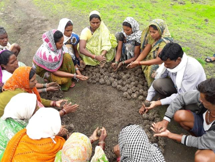
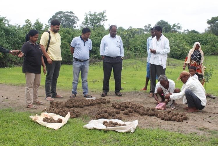
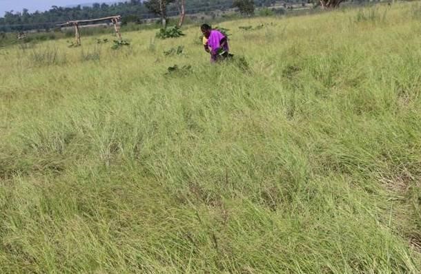
To prevent a recurrence, measures such as mopping for three years continuously, planting and seed sowing in areas where rootstocks seem to be less, and grass seed sowing are executed. The community institution ensures the collection of indigenous grass species, which are made into seed balls and sown before the advent of monsoon. These grass seeds germinate and grow in the rainy season, reducing the suitable environment for Lantana seed germination. Revegetation measures involve selecting and planting grazing hardy, fire hardy, and water hardy tree species such as bamboo, Khameer, Java Plum, Karanj (Pongame oil tree), Aonla, Harra, and other non-timber forest product-producing tree species. These plants are selected to create a three-tiered forest and sustainably provide food, fuel wood, and fodder. Once established, they do not allow Lantana to grow.
Biomass assessment is undertaken every year to assess the improvement in the status of the biomass in the plot, and the findings are shared with the community to motivate them to follow the rules and regulations formulated by the village institution. Cut and carry practices are allowed from the second year, but open grazing is prohibited, and Lantana eradication from nearby areas is required while cutting the grass. This helps to bring Lantana under control while sustainably utilizing the grass resources.
This initiative has ensured access to common lands for the local communities, access to fodder and green grass for livestock and the emergence of biodiversity in the area. This initiative is well recognised by Government institutions and policy makers.
2.3 Fotografías de la Tecnología
Galería de medios
2.5 País/ región/ lugares donde la Tecnología fue aplicada y que se hallan comprendidos por esta evaluación
País:
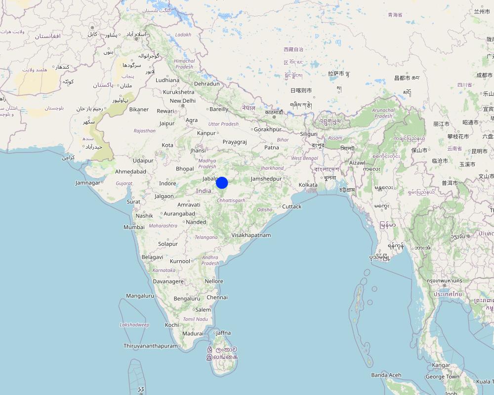
India
Región/ Estado/ Provincia:
Madhya Pradesh
Especifique más el lugar :
Village: Changaniya, Block- Bichhiya, Mandla
Especifique la difusión de la Tecnología:
- aplicada en puntos específicos/ concentrada en un área pequeña
¿El/los sitio(s) de la Tecnología se ubica(n) en un área de protección permanente?
No
Comentarios:
The technology is applied on common lands viz. common grazing land, forest, Gram Panchayat land
Map
×2.6 Fecha de la implementación
Indique año de implementación:
2016
2.7 Introducción de la Tecnología
Especifique cómo se introdujo la Tecnología:
- durante experimentos/ investigación
- mediante proyectos/ intervenciones externas
Comentarios (tipo de proyecto, etc.):
FES has done extensive research and studies to find out the appropriate technologies and approaches to remove the Lantana plants and rehabilitate the soil by restoring grasslands
3. Clasificación de la Tecnología MST
3.1 Propósito(s) principal(es) de la Tecnología MST
- mejorar la producción
- reducir, prevenir, restaurar la degradación del suelo
- conservar el ecosistema
- crear impacto económico benéfico
- crear impacto social benéfico
3.2 Tipo(s) actuales de uso de la tierra donde se aplica la Tecnología
Mezcla de tipos de uso de tierras dentro de la misma unidad de tierras: :
Sí
Especifique el uso combinado de tierras (cultivos/ pastoreo/ árboles):
- Silvo-pastoralismo

Tierra de pastoreo
Pastoreo extenso:
- Pastoralismo trashumante
Pastoreo intensivo/ producción de forraje:
- Cortar y llevar/ cero pastoreo
- Pastoreo mejorado
- Eradication of Lantana and restoring the grasslands
Tipo de animal:
- búfalos
- ganado - lechero
- cabras
¿Se practica el manejo integrado de cultivos - ganado?
No
Productos y servicios:
- economic security, investment prestige
Especies:
búfalos
Especies:
ganado - lechero
Especies:
cabras

Bosques
- Bosques/ zonas boscosas (semi) naturales
Bosques/ zonas boscosas (semi-) naturales: Especifique tipo de manejo:
- Eliminación de madera muerta/ de poda
- Uso de productos forestales no madereros
¿Los árboles especificados son deciduos o imperecederos?
- deciduo
Productos y servicios:
- Leña
- Frutos y nueces
- Pastoreo/ ramoneo
- Conservación/ Protección de la naturaleza
Comentarios:
The common land in villages which is generally not maintained, so allowing for the growth of invasive species, and unregulated open grazing is restored by the local community in a participatory manner for common benefits.
3.3 ¿Cambió el uso de tierras debido a la implementación de la Tecnología?
¿Cambió el uso de tierras debido a la implementación de la Tecnología?
- Sí (Por favor responda las preguntas de abajo referidas al uso de la tierra antes de implementar la Tecnología)
Mezcla de tipos de uso de tierras dentro de la misma unidad de tierras: :
Sí
Especifique el uso combinado de tierras (cultivos/ pastoreo/ árboles):
- Silvo-pastoralismo
Tierra de pastoreo
Pastoreo extenso:
- Pastoralismo trashumante
Pastoreo intensivo/ producción de forraje:
- Cortar y llevar/ cero pastoreo
- After restoration of common land, grasses are allowed to grow
¿Se practica el manejo integrado de cultivos - ganado?
No
Bosques
- Common village land and fringe areas of forests
- Indigenous grass restoration on common lands
¿Los árboles especificados son deciduos o imperecederos?
- deciduo
Productos y servicios:
- Leña
- Frutos y nueces
- Otros productos forestales
- Pastoreo/ ramoneo
- Conservación/ Protección de la naturaleza
Comentarios:
The common lands are restored to grasslands in a participatory manner
3.4 Provisión de agua
Provisión de agua para la tierra donde se aplica la Tecnología:
- de secano
Comentarios:
Mandla is a predominantly rainfed district of Madhya Pradesh, with agriculture being the mainstay of the local economy. The District receives an average annual rainfall of around 1280 mm, with the monsoon season being the primary source of precipitation.
3.5 Grupo MST al que pertenece la Tecnología
- veda de zona (detener uso, apoyar la restauración)
- pastoralismo y manejo de tierras de pastoreo
- cobertura de suelo/ vegetal mejorada
3.6 Medidas MST que componen la Tecnología

medidas vegetativas
- V4:reemplazo o eliminación de especies extrañas/ invasoras

medidas de manejo
- M1: Cambio de tipo de uso de la tierra
- M5: Control/ cambio de composición de las especies
Comentarios:
Invasive species are removed and the land and soil are rehabilitated by promoting the growth of indigenous grasses. During the first year, no grazing is allowed. In the second year of restoration only manual cutting/carry of grasses is permitted.
3.7 Principales tipos de degradación del suelo encarados con la Tecnología

degradación biológica
- Bc: reducción de la cobertura vegetal del suelo
- Bq: reducción de la cantidad/ biomasa
- Bf: efectos nocivos de los fuegos
- Bs: reducción en la calidad y composición/ diversidad de las especies
- Bl: pérdida de la vida del suelo
Comentarios:
Lantana has several disadvantages including being unpalatable, hindering the growth of other species, reducing the collection of NTFPs (non-timber forest products), and causing soil infertility and erosion. It also provides shelter to wild boar and tigers, leading to human and cattle conflict, and catching fire. Additionally, it has a hard seed cover and can remain dormant for up to 30 years, making eradication difficult.
3.8 Prevención, reducción o restauración de la degradación del suelo
Especifique la meta de la Tecnología con relación a la degradación de la tierra:
- reducir la degradación del suelo
- restaurar/ rehabilitar tierra severamente degradada
4. Especificaciones técnicas, actividades de implementación, insumos y costos
4.1 Dibujo técnico de la Tecnología

Especificaciones técnicas (relacionadas al dibujo técnico):
Drawing of this technology does not require as there no technical structure being build as part of the intervention. The images indicated a rehabilitated field after the eradication of Lantana.
4.2 Información general sobre el cálculo de insumos y costos
Especifique cómo se calcularon los costos e insumos:
- por área de Tecnología
Indique tamaño y unidad de área:
1
Si usa una unidad de área local, indique el factor de conversión a una hectárea (ej. 1 ha = 2.47 acres): 1 ha =:
ha
otra / moneda nacional (especifique):
INR (2023 April)
Si fuera relevante, indique la tasa de cambio de dólares americanos a la moneda local (ej. 1 U$ = 79.9 Reales Brasileros): 1 U$ =:
82,12
Indique el costo promedio del salario de trabajo contratado por día:
204
4.3 Actividades de establecimiento
| Actividad | Momento (estación) | |
|---|---|---|
| 1. | Removal of lantana | September-October (After Monsoon) |
| 2. | Preparation of seeds for sowing | Before the onset of Monsoon |
| 3. | Sowing of seeds | Just before the onset of monsoon or during the monsoon (June/July) |
Comentarios:
The cost for Lantana eradication is being shared between the community institution and project
4.4 Costos e insumos necesarios para el establecimiento
| Especifique insumo | Unidad | Cantidad | Costos por unidad | Costos totales por insumo | % de los costos cubiertos por los usuarios de las tierras | |
|---|---|---|---|---|---|---|
| Mano de obra | Removal of lantana | ha | 1,0 | 7229,0 | 7229,0 | 20,0 |
| Mano de obra | Land preparation for plantation | Person day | 1,0 | 200,0 | 200,0 | 100,0 |
| Mano de obra | Sowing of seeds | Person days | 2,0 | 200,0 | 400,0 | 100,0 |
| Equipo | Land preparation for plantation | ha | 1,0 | 1000,0 | 1000,0 | 50,0 |
| Material para plantas | Seeds or planting material | Ha | 1,0 | 1000,0 | 1000,0 | 50,0 |
| Material para plantas | Cow dung and compost material | Ha | 1,0 | 2500,0 | 2500,0 | 100,0 |
| Costos totales para establecer la Tecnología | 12329,0 | |||||
| Costos totales para establecer la Tecnología en USD | 150,13 | |||||
Si el usuario de la tierra no cubrió el 100% de los costos, indique quién financió el resto del costo:
The remaining cost is being covered by the project funds routed through community participation.
Comentarios:
The cost varies based on the density of lantana in the field. Depending on density, it varies from Rs 7729 per ha to Rs 2808 per ha. The work is done in a participatory manner by the local community. For the removal of the Lantana project funds routed, the plantation of indigenous grass seeds, curbing the regrowth of Lantana Camara, etc work is undertaken by the local community.
4.5 Actividades de establecimiento/ recurrentes
| Actividad | Momento/ frequencia | |
|---|---|---|
| 1. | Regular monitoring of the plantation area | July to November |
| 2. | Application of compost | June-July |
Comentarios:
Lantana Camara is a persistent weed, and even after complete eradication from common lands, its seeds can remain viable in the soil for a prolonged period. Therefore, it is essential to monitor the area regularly and prevent re-growth at the initial stage in the next few years.
Since the community works together on common lands in a participatory manner, there is very little maintenance cost involved in the process.
The density of lantana in the field can be categorized into three levels based on the number of bushes per area. A density of more than 1500 bushes per area is considered high density, while a density between 500-1500 is classified as moderately dense. A density of fewer than 500 bushes per area is known as low density.
4.6 Costos e insumos necesarios para actividades de mantenimiento/ recurrentes (por año)
| Especifique insumo | Unidad | Cantidad | Costos por unidad | Costos totales por insumo | % de los costos cubiertos por los usuarios de las tierras | |
|---|---|---|---|---|---|---|
| Mano de obra | Monitoring of plantation area | Person days | 12,0 | 200,0 | 2400,0 | 100,0 |
| Material para plantas | Application of compost | Ha | 1,0 | 2000,0 | 2000,0 | 100,0 |
| Indique los costos totales para mantenecer la Tecnología | 4400,0 | |||||
| Costos totales para mantener la Tecnología en USD | 53,58 | |||||
Si el usuario de la tierra no cubrió el 100% de los costos, indique quién financió el resto del costo:
The Project and other Government agencies support by providing the planting material
Comentarios:
This being a community-based approach a lot of activities are being done in a participatory way without the involvement of monetary transactions
4.7 Factores más determinantes que afectan los costos:
Describa los factores más determinantes que afectan los costos:
The density of lantana in the field is categorized into 3: more than 1500 bushes are considered high density, and between 500-1500 are considered moderately dense, while less than 500 is known as lowly dense. Such categories have a decicive impact on the costs.
5. Entorno natural y humano
5.1 Clima
Lluvia anual
- < 250 mm
- 251-500 mm
- 501-750 mm
- 751-1,000 mm
- 1,001-1,500 mm
- 1,501-2,000 mm
- 2,001-3,000 mm
- 3,001-4,000 mm
- > 4,000 mm
Especifique el promedio anual de lluvia (si lo conoce), en mm:
1427,70
Especificaciones/ comentarios sobre la cantidad de lluvia:
Monsoon season is June-September which has the majority of the rainfall
Indique el nombre de la estación metereológica de referencia considerada:
District at glance report of Ministry of Water Resources, Central Groundwater Board, North Central Region BHOPAL, 2013
Zona agroclimática
- Sub-húmeda
- semi-árida
The National Bureau of Soil Survey & Land Use Planning (NBSS&LUP) developed twenty agroecological zones based on the growing period as an integrated criterion of adequate rainfall and soil groups. It delineated boundaries adjusted to District boundaries with a minimal number of regions. Mandla District of Madhya Pradesh lies in a hot subhumid ecoregion with red and black soil.
Precepitation - 1000–1500mm; Potential Evapotranspiration -1300–1500 mm; Lenght of Growing Period-150–180days
5.2 Topografía
Pendientes en promedio:
- plana (0-2 %)
- ligera (3-5%)
- moderada (6-10%)
- ondulada (11-15%)
- accidentada (16-30%)
- empinada (31-60%)
- muy empinada (>60%)
Formaciones telúricas:
- meseta/ planicies
- cordilleras
- laderas montañosas
- laderas de cerro
- pies de monte
- fondo del valle
Zona altitudinal:
- 0-100 m s.n.m.
- 101-500 m s.n.m.
- 501-1,000 m s.n.m
- 1,001-1,500 m s.n.m
- 1,501-2,000 m s.n.m
- 2,001-2,500 m s.n.m
- 2,501-3,000 m s.n.m
- 3,001-4,000 m s.n.m
- > 4,000 m s.n.m
Indique si la Tecnología se aplica específicamente en:
- no relevante
Comentarios y especificaciones adicionales sobre topografía :
The project area is hilly and forested (Satpura Hill Range) and highly undulating with narrow strips of cultivated plains in the valley portion of the river. The plateau is in the northern part, formed by basalt and east-west trending hill in the southern region. The highest elevation is 934 m amsl in the northern part, and the lowest elevation is around 400 m amsl in the northwestern part of the area. Protected forest areas cover the majority of the site in the District as part of the Kanha National Park.
5.3 Suelos
Profundidad promedio del suelo:
- muy superficial (0-20 cm)
- superficial (21-50 cm)
- moderadamente profunda (51-80 cm)
- profunda (81-120 cm)
- muy profunda (>120 cm)
Textura del suelo (capa arable):
- áspera/ ligera (arenosa)
- mediana (limosa)
Textura del suelo (> 20 cm debajo de la superficie):
- mediana (limosa)
- fina/ pesada (arcilla)
Materia orgánica de capa arable:
- baja (<1%)
Si se halla disponible, adjunte una descripción completa de los suelos o especifique la información disponible, por ej., tipo de suelo, pH/ acidez de suelo, capacidad de intercambio catiónico, nitrógeno, salinidad, etc. :
Soil Testing Parameter status (Average) 2017-20 for the project areas is as follows. This data is based on the soil samples tested by the FES in its soil labs from the project villages.
Soil pH:- 5.906548628; EC (electrical conductivity):- 0.122993577; Soil Organic Carbon:- 0.83%; Nitrogen. :- 293.3696598; Phosphorus:- 25.77762582; Potassium (K):- 139.6696636; Sulphur (S):-18.93457993; Zinc (Zn):- 0.955246706; Boron (Bn):- 0.490850376
5.4 Disponibilidad y calidad de agua
Agua subterránea:
5-50 m
Disponibilidad de aguas superficiales:
mediana
Calidad de agua (sin tratar):
agua potable de mala calidad (requiere tratamiento)
La calidad de agua se refiere a:
agua subterránea y superficial
¿La salinidad del agua es un problema?
No
¿Se está llevando a cabo la inundación del área? :
No
Comentarios y especificaciones adicionales sobre calidad y cantidad de agua:
The groundwater status is within the safe limits as per the reports by the Government of Madhya Pradesh. People use water from rivers, streams, and traditional small wells for domestic purposes. In the absence of good vegetative cover, the rainwater washes off the fertile topsoil from the farmlands making the land barren and resulting in the siltation of ponds and other water bodies. Further, a heavy infestation of invasive species such as Lantana Camara compounds the degradation. The studied block Bichhiya is in a better position in terms of stage of groundwater development with 17%, while the average of the district is 7%. (stage of groundwater development refers to the % of groundwater being used for various purposes from the available groundwater in that area e.g. net annual groundwater availability in Bichhiya block is 9087 ham (hectare meters) while the existing annual ground water draft for all usage is 1523 ham, making it a 17% groundwater development stage)
Source: http://cgwb.gov.in/District_Profile/MP/Mandla.pdf
5.5 Biodiversidad
Diversidad de especies:
- elevada
Diversidad de hábitats:
- elevada
Comentarios y especificaciones adicionales sobre biodiversidad:
The area is surrounded by Kanha National Park and Phen Wildlife Sanctuary, with a good presence of forest area. World famous Kanha Tiger Reserve is situated in the Mandla District. Kanha is famous for Tiger and Barasingha. Kanha has numerous species of insects, butterflies, reptiles, fishes, and other lesser life forms. Important mammals, birds, reptiles, crustaceans, amphibians, insects, mollusks, and fishes are found in Kanha National Park. The faunal diversity of the district represents 32 wild animals, 63 birds, 4 fishes, and 9 reptile species, respectively. Regarding floral diversity, out of 1006 plant species available in the district, 162 are tree species, followed by 71 species of shrubs, 681 species of herbs, 51 species of climbers, 39 species of grasses, and 2 species of parasites. Mandla is richer in herbaceous species than other adjoining districts like Jabalpur and Seoni.
Source:- Documentation of Biodiversity Status in Mandla District of Madhya Pradesh.
https://mpsbb.mp.gov.in/completedProject/MB.pdf
5.6 Las características de los usuarios de la tierra que aplican la Tecnología
Sedentario o nómada:
- Sedentario
Orientación del mercado del sistema de producción:
- mixta (subsistencia/ comercial)
Ingresos no agrarios:
- > 50% de todo el ingreso
Nivel relativo de riqueza:
- pobre
- promedio
Individuos o grupos:
- individual/ doméstico
- grupos/ comunal
Nivel de mecanización:
- trabajo manual
- tracción animal
Género:
- mujeres
- hombres
Edad de los usuarios de la tierra:
- jóvenes
- personas de mediana edad
Indique otras características relevantes de los usuarios de las tierras:
The majority of the landusers belong to the tribal community, including some households from an ethnic community called Baiga.
https://en.wikipedia.org/wiki/Baiga_tribe
5.7 Área promedio de la tierra usada por usuarios de tierra que aplican la Tecnología
- < 0.5 ha
- 0.5-1 ha
- 1-2 ha
- 2-5 ha
- 5-15 ha
- 15-50 ha
- 50-100 ha
- 100-500 ha
- 500-1,000 ha
- 1,000-10,000 ha
- > 10,000 ha
¿Esto se considera de pequeña, mediana o gran escala (refiriéndose al contexto local)?
- pequeña escala
5.8 Tenencia de tierra, uso de tierra y derechos de uso de agua
Tenencia de tierra:
- comunitaria/ aldea
- individual, con título
Derechos de uso de tierra:
- individual
Derechos de uso de agua:
- comunitarios (organizado)
¿Los derechos del uso de la tierra se basan en un sistema legal tradicional?
Sí
Especifique:
The concerned authorities have issued landowners the land certificates.
Comentarios:
Communities have the legal rights for land ownership and other resources. The mentioned intervention is being undertaken on the commons, having legal rights of local self-governance institutions like Gram Panchayat or Joint Forest Management Committees.
5.9 Acceso a servicios e infraestructura
salud:
- pobre
- moderado
- bueno
educación:
- pobre
- moderado
- bueno
asistencia técnica:
- pobre
- moderado
- bueno
empleo (ej. fuera de la granja):
- pobre
- moderado
- bueno
mercados:
- pobre
- moderado
- bueno
energía:
- pobre
- moderado
- bueno
caminos y transporte:
- pobre
- moderado
- bueno
agua potable y saneamiento:
- pobre
- moderado
- bueno
servicios financieros:
- pobre
- moderado
- bueno
Comentarios:
Parts of the District suffer from poor road and transportation network
6. Impactos y comentarios para concluir
6.1 Impactos in situ demostrados por la Tecnología
Impactos socioeconómicos
Producción
producción de forraje
Comentarios/ especifique:
From the second year onwards after the restoration of the grassland, the grass can be made available for cattle through a cut and feed method. This involves cutting the grass in a controlled manner and providing it to the cattle as feed. By using this method, the grass can be harvested at its optimum stage of growth, and the cattle can be provided with high-quality feed throughout the year. Additionally, this method allows for better utilization of the grass, minimizing any waste or overgrazing of the grassland.
producción animal
Comentarios/ especifique:
Availability of fodder to villages from common lands
manejo de tierras
Comentarios/ especifique:
Lantana Camara is a problematic weed that has many disadvantages. It can reduce biodiversity, decrease soil fertility, and impede the growth of other plant species. Moreover, it can also be toxic to livestock and humans if ingested.
The restoration of grasslands and the eradication of lantana can help in land management. By removing the weed, the growth of other plant species can be promoted, leading to increased biodiversity and improved soil fertility. The removal of lantana can also help to reduce the risk of wildfires, as it is known to be a highly flammable plant.
Otros impactos socioeconómicos
Restoration of grassland and regulating the use of indigenous grasses as fodder for cattle
Comentarios/ especifique:
The restoration of grassland and regulation of indigenous grasses for cattle fodder can benefit villagers both socially and economically. Socially, it promotes community involvement and ownership of the land, while promoting sustainable land use practices benefit the environment and community. Economically, the restoration provides a sustainable source of income through the sale of milk and meat products, and eco-tourism can help to boost the local economy.
Impactos ecológicos
Suelo
cubierta del suelo
Comentarios/ especifique:
Lantana is known to release allelopathic compounds into the soil, which can inhibit the growth of other plant species. By removing Lantana, the negative impact of these compounds on the soil are reduced, which can promote the growth of a wider range of plants.
Biodiversidad: vegetación, animales
Cubierta vegetal
Comentarios/ especifique:
Diversified vegetation cover supports land restoration
diversidad vegetal
especies invasoras extrañas
diversidad animal
Reducción de riesgos de desastres y riesgos climáticos
riesgo de incendio
Comentarios/ especifique:
Eradicating Lantana Camara reduces the risk of wildfires as it is highly flammable and provides a significant fuel source. Removing Lantana reduces the fuel source for fires, especially in areas prone to wildfires or near human settlements. Moreover, removing Lantana can promote the growth of more fire-resistant plant species, creating a more resilient ecosystem that can better withstand natural disasters.
Especifique la evaluación de los impactos en el sitio (mediciones):
All of the impact areas indicated in the document are based on the discussions with community members, community institutions and project implementing teams. However, a detailed scientific assessment has not taken place so far.
6.2 Impactos fuera del sitio demostrados por la Tecnología
daño a campos de vecinos
Comentarios/ especifique:
The spread of Lantana Camara seeds was reduced within neighboring fields
6.3 Exposición y sensibilidad de la Tecnología al cambio climático gradual y a extremos relacionados al clima/ desastres (desde la percepción de los usuarios de tierras)
Extremos (desastres) relacionados al clima
Desastres climatológicos
| ¿Cómo es que la tecnología soporta esto? | |
|---|---|
| incendio forestal | muy bien |
| incendio | muy bien |
Comentarios:
All of the impact areas indicated in the document are based on the discussions with community members, community institutions and project implementing teams. However, a detailed scientific assessment has not taken place so far.
6.4 Análisis costo-beneficio
¿Cómo se comparan los beneficios con los costos de establecimiento (desde la perspectiva de los usuarios de tierra)?
Ingresos a corto plazo:
positivo
Ingresos a largo plazo:
muy positivo
¿Cómo se comparan los beneficios con los costos de mantenimiento/ recurrentes (desde la perspectiva de los usuarios de tierra)?
Ingresos a corto plazo:
muy positivo
Ingresos a largo plazo:
muy positivo
Comentarios:
Overall, this is a very cost effective technology without having any negative impact on the human and the natural environment
6.5 Adopción de la Tecnología
- 1-10%
Si tiene la información disponible, cuantifique (número de hogares y/o área cubierta):
On more than 100 locations common land locations this work has been undertaken
De todos quienes adoptaron la Tecnología, ¿cuántos lo hicieron espontáneamente, por ej. sin recibir nada de incentivos/ materiales:
- 0-10%
Comentarios:
This being a relatively new intervention, spontaneous adoption will take some time
6.6 Adaptación
¿La tecnología fue modificada recientemente para adaptarse a las condiciones cambiantes?
No
6.7 Fuerzas/ ventajas/ oportunidades de la Tecnología
| Fuerzas/ ventajas/ oportunidades desde la perspectiva del usuario de la tierra |
|---|
| Eradication of Lantana Camara reduces its spread and provided access into the forest areas |
| The common lands are restored to grasslands |
| Fodder available for cattle |
| Fuerzas/ ventajas/ oportunidades desde la perspectiva del compilador o de otra persona de referencia clave |
|---|
| Rehabilitation of the soil by eradication of Lantana Camara |
| Sustainable use of common resources for the purpose of biodiversity restoration |
| A participatory approach for resolving common issues |
6.8 Debilidades/ desventajas/ riesgos de la Tecnología y formas de sobreponerse a ellos
| Debilidades/ desventajas/ riesgos desde la perspectiva del usuario de la tierra | ¿Cómo sobreponerse a ellas? |
|---|---|
| Continuous monitoring of the regrowth of Lantana Camara as the seeds stay dormant in the soil for many years | Monitoring, and promoting growth with indigenous grasses, local trees, etc. so that the land is not kept fallow |
| Conflict among the members of community institutions for the management of the common property resources | Handholding and training of community institutions |
| Debilidades/ desventajas/ riesgos desde la perspectiva del compilador o de otra persona de referencia clave | ¿Cómo sobreponerse a ellas? |
|---|---|
| Currently, the program funds the eradication of Lantana Camara undertaken by the local community | Including the work under Mahatma Gandhi National Rural Employment Guarantee Act 2005 or MGNREGA |
| Mechanism to scale up the program participatory approach to manage common land resources | Integrating it with other government schemes |
7. Referencias y vínculos
7.1 Métodos/ fuentes de información
- visitas de campo, encuestas de campo
10
- entrevistas con usuarios de tierras
5
- compilación de informes y otra documentación existente
2
¿Cuándo se compilaron los datos (en el campo)?
22/02/2023
Comentarios:
During the field visit along with visiting the sites, discussions were held with community institutions, community members, the project implementing agency and other concerned stakeholders to understand the processes, impacts, challenges and future plans
7.2 Vínculos a las publicaciones disponibles
Título, autor, año, ISBN:
Ecological Restoration of Lantana-Invaded Landscapes in Corbett Tiger Reserve, India Suresh Babuy Amit Love and Cherukuri Raghavendra Babu
¿Dónde se halla disponible? ¿Costo?
https://www.jstor.org/stable/43441335
Título, autor, año, ISBN:
Impacts of biochar application on upland agriculture: A review Kumuduni Niroshika Palansooriyaa,1, Yong Sik Oka,1, Yasser Mahmoud Awada, Sang Soo Leeb, Jwa-Kyung Sungc, Agamemnon Koutsospyrosd, Deok Hyun Moone,∗
¿Dónde se halla disponible? ¿Costo?
https://pubmed.ncbi.nlm.nih.gov/30616189/
7.3 Vínculos a la información relevante disponible en línea
Título/ descripción:
Lantana Demo Video
URL:
https://www.youtube.com/watch?v=1d80KyKPkDo
Vínculos y módulos
Expandir todo Colapsar todosVínculos
No hay vínculos
Módulos
No se hallaron módulos