Seedbed preparation and spillways construction. Top Left: The construction of the stone dikes. Top Right: Soil leveling of the fields for improved water infiltration. Bottom Left: Local community workers inspecting the dike. Bottom Right: A well prepared seedbed after leveling. (Shukri Ismail)

Marab - Water Harvesting Based Floodplain Agriculture (Jordanie)

Marab in Arabic “المرب”

Description

The Marab is a local downstream water harvesting measure in an integrated watershed context, where up/midstream users and applied land management practices affect the Marab.
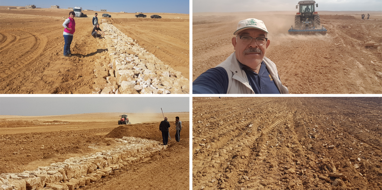
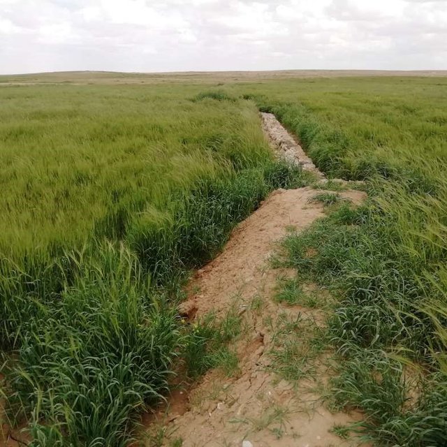
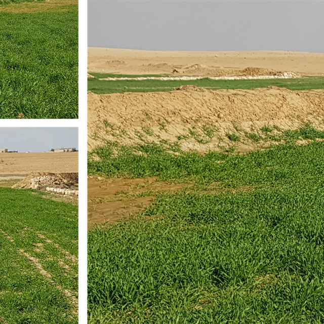
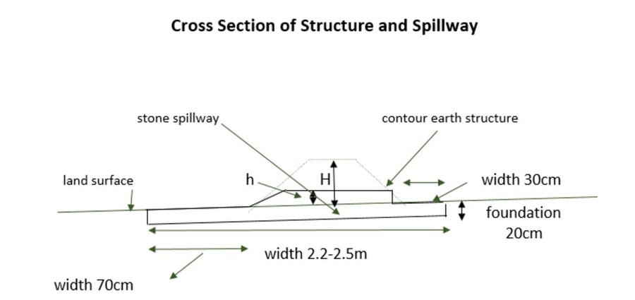
The technology diverts and spreads excess runoff over deep-soil flood plains. The technology comprises local gully-filling, grading/leveling of seed bed, and construction of a bund-and-spillway system creating several compartments for flood-irrigated agriculture.

Arid drylands of Jordan receive less than 200mm average annual rainfall. The specific site is located close by Al Majeddyeh village, around 30km south-east of Amman. The average annual rainfall at the site is around 130mm. The average temperature is above 18 degrees Celsius. The human environment is characterized by agro-pastoralists. These are farmers that live in permanent houses but transport their livestock to graze. As consequence of the natural environment and mis-management (e.g. overgrazing) desertification has been an increasingly problem, not only from an environmental perspective (e.g. carbon stocking; lack of water), but also from an socio-economic perspective, because desertification leads to reduced productive lands, consequently resulting in less income for the rural population.
Therefore, the aim of the technology is to achieve high-yield agriculture through flood/macro-catchment water harvesting in arid environments commonly unsuitable for field crop agriculture, creating beneficial impact for local land users. The high yield barley is fed to the livestock (goats and sheeps) of the local agro-pastoralists. Applied in an integrated watershed approach, it meets agricultural demands and motivates sustainable dryland ecosystem management in the uplands. The Marab-technology has a buffering effect on extreme runoff through water retention, for further use in downstream areas, including the trapping of relative fertile sediments from upstream. As the Marab increases yields, it also improves the livelihood of the local population.

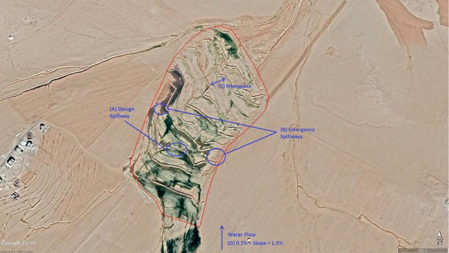
The Marab-technology is a macro-catchment water harvesting technology. The Marab is located in the natural depression of the watershed (10 square kilometres), therefore most of the water from the watershed is captured here, instead of being spilled away. Combining this natural depression with the construction of bunds and specific soil leveling, leads to decreased run-off, thus highly increased water infiltration and soil moisture. Thereby, the biomass-production increased as well.
The watershed is characterized by degraded lands upstream (720 ha), where low yield and subsidized barley cultivation is practiced, and by gullies. In a limited part (12 ha) of the upstream area, Vallerani micro-catchments are implemented as a pilot-plot. This might seem contradicting since upstream micro-catchment water harvesting decreases the water in the Marab downstream. However, the Vallerani micro-catchments also have beneficial impacts on the watershed and the Marab, such as flattening peak water flows, reducing erosion and providing fodder. The reduction in water run-off for the Marab as consequence of the Vallerani structures is not significant, due to the small size of the pilot area. But the relations between upstream and downstream should be taken into account.

Upstream watershed measures to buffer and/or avoid extreme runoff events (extreme downstream flooding) in the Marab such as micro-catchment water harvesting structures (Vallerani tractor plow system) and the out-planting of native shrub seedlings, as well as the stabilization of erosive gully systems through gully plugging and revegetation of side banks are advised to be taken before implementing the Marab technology downstream, as they safeguard and protect the Marab. But they are not further into account in this documentation.
Establishment of the downstream Marab system includes:
•Local filling of downstream gull(system) with deep soil
•Leveling/grading of flood plains
•Construction of earth bunds
•Construction of the spillways (stone made)
• Seedbed preparation for planting annual crop such as barley

Marab agricultural production is high and stable. It can reach around 5-6 t ha-1 of barley, compared with the low and strongly varying yields of around 0.05-0.30 t ha-1 in traditionally, without macro water harvesting, cultivated barley. Marab barley produces grains (for fodder and reseeding purposes) and requires local inputs, such as fertilizer. The Marab mitigates downstream flooding and loss of sediments from the watershed. Local farmers applying the Marab technology are very satisfied, because of the extremely increased yield as consequence of the technology. However, as water is captured in the watershed, tensions may arise between the downstream (Marab) users and the upstream users.

Lieu

Lieu: Al Majeddyeh Village, Al Jiza District, Jordanie

Nbr de sites de la Technologie analysés: site unique

Géo-référence des sites sélectionnés
  • 36.13303, 31.72667

Diffusion de la Technologie: appliquée en des points spécifiques ou concentrée sur une petite surface

Dans des zones protégées en permanence ?: Non

Date de mise en oeuvre: 2017

Type d'introduction
Late stage barley in the Marab. This picture shows well the extraordinary height of the barley, which indicates relative healthy barley. (Mira Haddad)
Barley yield in the Marab (Shukri Ismail)

Classification de la Technologie

Principal objectif
  • améliorer la production
  • réduire, prévenir, restaurer les terres dégradées
  • préserver l'écosystème
  • protéger un bassin versant/ des zones situées en aval - en combinaison avec d'autres technologies
  • conserver/ améliorer la biodiversité
  • réduire les risques de catastrophes
  • s'adapter au changement et aux extrêmes climatiques et à leurs impacts
  • atténuer le changement climatique et ses impacts
  • créer un impact économique positif
  • créer un impact social positif
L'utilisation des terres
Les divers types d'utilisation des terres au sein du même unité de terrain: Oui - Agropastoralisme (y compris les systèmes culture-élevage intégrés)

  • Terres cultivées
    • Cultures annuelles: céréales - orge
    Nombre de période de croissance par an: : 1
    Est-ce que les cultures intercalaires sont pratiquées? Non
    Est-ce que la rotation des cultures est appliquée? Non
  • Pâturages
    • Pastoralisme de type semi-nomade
    • Affouragement en vert/ zéro-pâturage
    Type d'animal: caprine, ovins
    Est-ce que la gestion intégrée cultures-élevage est pratiquée? Non

Approvisionnement en eau
  • pluvial
  • mixte: pluvial-irrigué
  • pleine irrigation

But relatif à la dégradation des terres
  • prévenir la dégradation des terres
  • réduire la dégradation des terres
  • restaurer/ réhabiliter des terres sévèrement dégradées
  • s'adapter à la dégradation des terres
  • non applicable
Dégradation des terres traité
  • érosion hydrique des sols - Wt: perte de la couche superficielle des sols (couche arable)/ érosion de surface, Wg: ravinement/ érosion en ravines, Wo: effets hors-site de la dégradation
  • dégradation physique des sols - Pk: scellage et encroûtement
  • dégradation biologique - Bc: réduction de la couverture végétale, Bq: baisse de la quantité/ biomasse
  • dégradation hydrique - Ha: aridification
Groupe de GDT
  • Amélioration de la couverture végétale/ du sol
  • récupération/ collecte de l'eau
  • dérivation et drainage de l'eau
Mesures de GDT
  • pratiques agronomiques - A3: Traitement de la couche superficielle du sol, A4: Traitement de la couche profonde du sol
  • structures physiques - S2: Diguettes, digues , S3: Fossés étagés, canaux, voies d'eau

Dessin technique

Spécifications techniques
The overall Marab (reshaped flood plain) area is 10 hectares. The natural flood plain was leveled up to the sides; the natural slope in flow direction ranges between 0.1 and 1.5% (D). The later stone bund construction (soil relocation) and siltation/erosion processes over time develop a slight step-terraced bund compartment system, with the single compartments having much smaller slope than the overall Marab. At the sides, the levelled area slightly increases towards the natural terrain (natural terrain at the sides is around 0.1 to 0.3m higher compared with the leveled Marab). This avoids side outflow of water during design storms (*). Bund structures, along the contour, are built with a loader up to around 0.7 to 1.0m height and around 2.0 – 3.0m bottom width. The bunds are built with compaction through the loader. Interspace between the bunds is between 10-50 meters (C), depending on the local slope in the flow direction, having around 0.1 to 0.3m soil surface elevation difference between the bunds. Stone made design-spillways (A) are being constructed around the middle of each bund, with certain position change between the bund in downstream direction. Thus, spillways do not perfectly align with respect to the bund, but create a meandering flow around the center. The stone-protected design-spillways are designed to safely route at least the expected 2-5 year return period flood event. The Marab plain is not perfectly even, especially at the sides, to avoid water flowing around the bunds during design storms. However, the Marab-technology is also designed to cope with more extreme events, a storm of 5-10 return period, without significant damages. Therefore, there are emergency-spillways (**) implemented at the sides of each bund (B). These emergency-spillways allow excess water to flow out sideways rather than flow over the bund which would damage the structures. Note:
Based on above considerations and calculations bund spillway lengths reach 50-60m in the specific watershed.

* A design storm is a rainfall event that results in a flood event as water accumulates throughout the watershed. The Marab is designed to harvest the water optimally by (design) spill ways that keep the water in the Marab. A design storm relates to a certain return period. In general a longer return period (i.e. less frequent) accounts for a more intense event hence a more severe flooding event.
** An emergency spill way is a structure that is designed to discharge excess water coming from storms more extreme than the design storm (i.e. with less frequent storms). In practice this means that the Marab is protected from excess water.
Author: Joren Verbist (Extracted from Google Earth Pro on Jan 7th 2019)
The cross-section shows the dimensions. Downstream of a bund the width is 70 centimeter. The foundation is 20 centimeter high. The upstream width is 30 centimeter. The total width of the bund varies between 2.2 meter and 2.5 meter.
Author: Stefan Strohmeier

Mise en œuvre et entretien : activités, intrants et coûts

Calcul des intrants et des coûts
  • Les coûts sont calculés : par superficie de la Technologie (taille et unité de surface : 10 ha)
  • Monnaie utilisée pour le calcul des coûts : dollars américains
  • Taux de change (en dollars américains - USD) : 1 USD = n.d.
  • Coût salarial moyen de la main-d'oeuvre par jour : 35
Facteurs les plus importants affectant les coûts
The special and heavy machinery affect the cost significantly, since these were not available in the area. The implementation of the technology is labour intensive, therefore labour costs are significant as well. However, these costs are initially, so these specific costs are almost zero after establishment. In addition, all the maintenance is payed for by the land users. So, only the establishment was payed for by external parties.
Activités de mise en place/ d'établissement
  1. Implement upstream watershed rehabilitation measure (e.g. Upstream Vallerani micro water harvesting) (Calendrier/ fréquence: Prior of Marab-Technology construction)
  2. Implement gully rehabilitation measure (e.g. Midstream gully rehabilitation) (Calendrier/ fréquence: Prior of Marab-Technology construction)
  3. Marab site selection (flood plain): topographic assessment (slope, soil depth, etc.) and consideration of watershed hydrology (e.g. for bund and spillway design) (Calendrier/ fréquence: Before the rainy season)
  4. Grading/levelling of natural flood plain incl. gully fill (with soil material) (Calendrier/ fréquence: season (Aug. – Nov.))
  5. Implement bund structures (based on step 4) (Calendrier/ fréquence: season (Aug. – Nov.))
  6. Construct stone made design and emergence spillways (based on step 5) (Calendrier/ fréquence: season (Aug. – Nov.))
  7. Preparation of compartmentalized agricultural fields (bund interspaces) for field crop agriculture (Calendrier/ fréquence: season (Aug. – Nov.))
Intrants et coûts de mise en place (per 10 ha)
Spécifiez les intrants Unité Quantité Coûts par unité (dollars américains) Coût total par intrant (dollars américains) % des coût supporté par les exploitants des terres
Main d'œuvre
Local Workers person-days 50,0 35,0 1750,0
Land Survey person-days 6,0 35,0 210,0
Engineer (+assistance) person-days 15,0 50,0 750,0
Drivers of heavy machinery person-days 12,0 35,0 420,0
Equipements
Grader machine-days 3,0 250,0 750,0
Loader machine-days 10,0 250,0 2500,0
Deep Plow machine-days 3,0 200,0 600,0
Tractor (to pull the shallow and deep plow) machine-days 5,0 200,0 1000,0
Shallow Plow machine-days 2,0 200,0 400,0
Water Tank Truck Tank 1,0 50,0 50,0
Small Equipment (Shovel, pickaxe, buckets) Equipment 1,0 200,0 200,0
Matériaux de construction
Stones Kubic Metre 200,0 10,0 2000,0
Autre
Transportation of heavy machinery 1,0 2000,0 2000,0
Security 1,0 300,0 300,0
Coût total de mise en place de la Technologie 12'930.0
Coût total de mise en place de la Technologie en dollars américains (USD) 12'930.0
Activités récurrentes d'entretien
  1. Maintaining the structures based on observations and possible damages after the rainy season, so no clear maintenance plans (Calendrier/ fréquence: Before the rainy season (Oct. – Nov.)/upon observation)
Intrants et coûts de l'entretien (per 10 ha)
Spécifiez les intrants Unité Quantité Coûts par unité (dollars américains) Coût total par intrant (dollars américains) % des coût supporté par les exploitants des terres
Main d'œuvre
Engineer person days per year 2,0 50,0 100,0 100,0
Worker person days per year 6,0 35,0 210,0 100,0
Equipements
Loader machine days per year 1,0 250,0 250,0 100,0
Matériaux de construction
Stones Kubic Metre 10,0 10,0 100,0 100,0
Coût total d'entretien de la Technologie 660.0
Coût total d'entretien de la Technologie en dollars américains (USD) 660.0

Environnement naturel

Précipitations annuelles
  • < 250 mm
  • 251-500 mm
  • 501-750 mm
  • 751-1000 mm
  • 1001-1500 mm
  • 1501-2000 mm
  • 2001-3000 mm
  • 3001-4000 mm
  • > 4000 mm
Zones agro-climatiques
  • humide
  • subhumide
  • semi-aride
  • aride
Spécifications sur le climat
Précipitations moyennes annuelles en mm : 130.0
In the specific site/dry areas of Jordan rainy season usually ranges from November until April
Queen Alia International Airport long-time avergae annual rainfall is around 150 mm (around 10km west of the site)
At the site a rainfall tipping bucket has been installed in 2016.
Nom de la station météorologique : Queen Alia International Airport
The maximum temperature usually occurres in August.
The average daily maximum temperature is 25.01 °C.
The average daily minimum temperature is 8.5 °C
Pentes moyennes
  • plat (0-2 %)
  • faible (3-5%)
  • modéré (6-10%)
  • onduleux (11-15%)
  • vallonné (16-30%)
  • raide (31-60%)
  • très raide (>60%)
Reliefs
  • plateaux/ plaines
  • crêtes
  • flancs/ pentes de montagne
  • flancs/ pentes de colline
  • piémonts/ glacis (bas de pente)
  • fonds de vallée/bas-fonds
Zones altitudinales
  • 0-100 m
  • 101-500 m
  • 501-1000 m
  • 1001-1500 m
  • 1501-2000 m
  • 2001-2500 m
  • 2501-3000 m
  • 3001-4000 m
  • > 4000 m
La Technologie est appliquée dans
  • situations convexes
  • situations concaves
  • non pertinent
Profondeurs moyennes du sol
  • très superficiel (0-20 cm)
  • superficiel (21-50 cm)
  • modérément profond (51-80 cm)
  • profond (81-120 cm)
  • très profond (>120 cm)
Textures du sol (de la couche arable)
  • grossier/ léger (sablonneux)
  • moyen (limoneux)
  • fin/ lourd (argile)
Textures du sol (> 20 cm sous la surface)
  • grossier/ léger (sablonneux)
  • moyen (limoneux)
  • fin/ lourd (argile)
Matière organique de la couche arable
  • abondant (>3%)
  • moyen (1-3%)
  • faible (<1%)
Profondeur estimée de l’eau dans le sol
  • en surface
  • < 5 m
  • 5-50 m
  • > 50 m
Disponibilité de l’eau de surface
  • excès
  • bonne
  • moyenne
  • faible/ absente
Qualité de l’eau (non traitée)
  • eau potable
  • faiblement potable (traitement nécessaire)
  • uniquement pour usage agricole (irrigation)
  • eau inutilisable
La qualité de l'eau fait référence à: eaux de surface
La salinité de l'eau est-elle un problème ?
  • Oui
  • Non

Présence d'inondations
  • Oui
  • Non
Diversité des espèces
  • élevé
  • moyenne
  • faible
Diversité des habitats
  • élevé
  • moyenne
  • faible

Caractéristiques des exploitants des terres appliquant la Technologie

Orientation du système de production
  • subsistance (auto-approvisionnement)
  • exploitation mixte (de subsistance/ commerciale)
  • commercial/ de marché
Revenus hors exploitation
  • moins de 10% de tous les revenus
  • 10-50% de tous les revenus
  • > 50% de tous les revenus
Niveau relatif de richesse
  • très pauvre
  • pauvre
  • moyen
  • riche
  • très riche
Niveau de mécanisation
  • travail manuel
  • traction animale
  • mécanisé/ motorisé
Sédentaire ou nomade
  • Sédentaire
  • Semi-nomade
  • Nomade
Individus ou groupes
  • individu/ ménage
  • groupe/ communauté
  • coopérative
  • employé (entreprise, gouvernement)
Genre
  • femmes
  • hommes
Âge
  • enfants
  • jeunes
  • personnes d'âge moyen
  • personnes âgées
Superficie utilisée par ménage
  • < 0,5 ha
  • 0,5-1 ha
  • 1-2 ha
  • 2-5 ha
  • 5-15 ha
  • 15-50 ha
  • 50-100 ha
  • 100-500 ha
  • 500-1 000 ha
  • 1 000-10 000 ha
  • > 10 000 ha
Échelle
  • petite dimension
  • moyenne dimension
  • grande dimension
Propriété foncière
  • état
  • entreprise
  • communauté/ village
  • groupe
  • individu, sans titre de propriété
  • individu, avec titre de propriété
Droits d’utilisation des terres
  • accès libre (non organisé)
  • communautaire (organisé)
  • loué
  • individuel
Droits d’utilisation de l’eau
  • accès libre (non organisé)
  • communautaire (organisé)
  • loué
  • individuel
  • NA
Accès aux services et aux infrastructures
santé

pauvre
bonne
éducation

pauvre
bonne
assistance technique

pauvre
bonne
emploi (par ex. hors exploitation)

pauvre
bonne
marchés

pauvre
bonne
énergie

pauvre
bonne
routes et transports

pauvre
bonne
eau potable et assainissement

pauvre
bonne
services financiers

pauvre
bonne

Impact

Impacts socio-économiques
Production agricole
en baisse
en augmentation


The crops produced are used as fodder

production fourragère
en baisse
en augmentation

Quantité avant la GDT: 0.05ton/ha
Quantité après la GDT: 5ton/ha
The production of the fodder is increased as the barley yield is mostly used to feed animals and also the stubble is grazed.

qualité des fourrages
en baisse
en augmentation


The barley is fed to the livestock

surface de production (nouvelles terres cultivées/ utilisées)
en baisse
en augmentation


Due to the bunds (but very limited and inevitable)

gestion des terres
entravé
simplifié

dépenses pour les intrants agricoles
en augmentation
en baisse


Expenses are slightly increased due to possible maintenance of the Marab. However, the increased yield justifies this.

revenus agricoles
en baisse
en augmentation

charge de travail
en augmentation
en baisse


Due to possible maintenance

Impacts socioculturels
sécurité alimentaire/ autosuffisance
réduit
amélioré

connaissances sur la GDT/ dégradation des terres
réduit
amélioré


During the construction, local community were hired as workers, this has significantly boosted their knowlegde about SLM.

Impacts écologiques
récolte/ collecte de l'eau (ruissellement, rosée, neige, etc.)
réduit
amélioré

ruissellement de surface
en augmentation
en baisse

drainage de l'excès d'eau
réduit
amélioré

nappes phréatiques/ aquifères
en baisse
rechargé

humidité du sol
en baisse
en augmentation

couverture du sol
réduit
amélioré

perte en sol
en augmentation
en baisse

accumulation de sol
en baisse
en augmentation

encroûtement/ battance du sol
en augmentation
réduit

matière organique du sol/ au dessous du sol C
en baisse
en augmentation

couverture végétale
en baisse
en augmentation

biomasse/ au dessus du sol C
en baisse
en augmentation

impacts des inondations
en augmentation
en baisse

impacts de la sécheresse
en augmentation
en baisse

Impacts hors site
inondations en aval (indésirables)
en augmentation
réduit


Reduced downstream flooding is desired

envasement en aval
en augmentation
en baisse


Reduced downstream siltation is desired

Analyse coûts-bénéfices

Bénéfices par rapport aux coûts de mise en place
Rentabilité à court terme
très négative
très positive

Rentabilité à long terme
très négative
très positive

Bénéfices par rapport aux coûts d'entretien
Rentabilité à court terme
très négative
très positive

Rentabilité à long terme
très négative
très positive

The initial investment is quite large. Therefore, the short term returns is classified as slightly negative. After some seasons with good (stable) crop yield the return of investment is positive. Long term benefits are classified positively.

Changement climatique

Changements climatiques progressifs
précipitations annuelles décroît

pas bien du tout
très bien
Extrêmes climatiques (catastrophes)
pluie torrentielle locale

pas bien du tout
très bien
crue éclair

pas bien du tout
très bien

Adoption et adaptation de la Technologie

Pourcentage d'exploitants des terres ayant adopté la Technologie dans la région
  • cas isolés/ expérimentaux
  • 1-10%
  • 11-50%
  • > 50%
Parmi tous ceux qui ont adopté la Technologie, combien d'entre eux l'ont fait spontanément, à savoir sans recevoir aucune incitation matérielle ou aucun paiement ?
  • 0-10%
  • 11-50%
  • 51-90%
  • 91-100%
Nombre de ménages et/ou superficie couverte
These are some farmers that live near the Marab. They try to copy the Marab in their fields.
La Technologie a-t-elle été récemment modifiée pour s'adapter à l'évolution des conditions ?
  • Oui
  • Non
A quel changement ?
  • changements/ extrêmes climatiques
  • évolution des marchés
  • la disponibilité de la main-d'œuvre (par ex., en raison de migrations)
The spillway design can be adapted to variable surface runoff occurrence (affected by climate change).

Conclusions et enseignements tirés

Points forts: point de vue de l'exploitant des terres
  • The farmers highly appreciate the improved economic situation as consequence of the increased yield.
  • A strength of the Marab technology is that water is harvested and minimally spilled away, preventing top-soil erosion and accumulating soil organic matter consequently preserving soil fertility.
  • The crop produces grains: can be (partially) used for re-seeding in the coming seasons; economic gain + increase resilience.
Points forts: point de vue du compilateur ou d'une autre personne-ressource clé
  • Economic improvement through targeted agricultural interventions in the most suitable location(s) of a watershed. This aims at decreasing the pressure on the fragile dry land ecosystem. The locally increased yield raises awareness on non-sufficient field crop agriculture in uplands (commonly achieved) and might increase the willingness for more nature-based sustainable land management measures in the less fertile and runoff generating (more vulnerable uplands) parts of the watershed. Therefore, the Marab technology could be a starting point for a watershed rehabilitation initiative.
  • The Marab technology creates an opportunity for multiple crop introduction (due to natural flood irrigation) – aside from barley monoculture (agro-diversity).
  • Increased water infiltration conserves water and might lead to deep percolation (groundwater recharge).
Faiblesses/ inconvénients/ risques: point de vue de l'exploitant des terrescomment surmonter
  • The Marab depends on upstream water users; can lead to increased tensions Agreement among the community - conducting contacts/contracts among upstream and downstream farmers. Joint watershed management and benefit share could be mediate these tension. And might even lead to watershed rehabilitation.
  • High initial investment and partially high maintenance costs (including machinery) Once the implementation is linked with larger environmental benefits – communities might receive funds from the government or international donors.
  • Loss of cultivation area where the bunds are placed Unavoidable. However, the gain of interspaces exceeds these losses several times.
Faiblesses/ inconvénients/ risques: point de vue du compilateur ou d'une autre personne-ressource clécomment surmonter
  • Tensions among multiple actors in the watershed (selection of Marab area) Develop institutions that could avoid these tensions by establishing agreements, contracts, rules, or regulations.
  • Heavy machinery in a vulnerable ecosystems – can induce other requests/use by locals (improper use) Targeted policies in place & enforcements
  • Increasing wealth inequality between farmers and/or communities. Creation of institutions, which assure fair distribution. This would benefit the whole watershed.

Références

Compilateur
  • Joren Verbist
Editors
  • Mira Haddad
  • Enrico Bonaiuti
Examinateur
  • Rima Mekdaschi Studer
Date de mise en oeuvre: 25 mai 2020
Dernière mise à jour: 21 décembre 2020
Personnes-ressources
Description complète dans la base de données WOCAT
Données de GDT correspondantes
La documentation a été facilitée par
Institution Projet
Références clés
  • Strohmeier, S. (2017). Dimensioning of Marab in Majidyya.:
  • Strohmeier, S. (2017). Watershed Restoration in Baia Areas of Jordan Technology Packages for Controlling and Monitoring Gully Erosion.: https://mel.cgiar.org/projects/jordan-watershed-restoration-project
  • Mira Haddad, Stefan Strohmeier. (12/12/2017). Treated upland areas map. Jordan: International Center for Agricultural Research in the Dry Areas (ICARDA).: https://hdl.handle.net/20.500.11766/9108
  • Stefan Strohmeier, Mira Haddad, Ismail Shukri. (8/11/2018). Marab - water harvesting based agriculture.: https://hdl.handle.net/20.500.11766/9069
  • Boubaker Dhehibi, Mira Haddad, Stefan Strohmeier, Masnat El-Hiary. (24/7/2020). Enhancing a Traditional Water Harvesting Technique in Jordan’s Agro-pastoral Farming System. Lebanon: International Center for Agricultural Research in the Dry Areas (ICARDA).: https://hdl.handle.net/20.500.11766/11506
Liens vers des informations pertinentes disponibles en ligne
This work is licensed under Creative Commons Attribution-NonCommercial-ShareaAlike 4.0 International