E-Prakriti - An Approach Towards GIS Based Planning For Natural Farming [Inde]
- Création :
- Mise à jour :
- Compilateur : Santosh Gupta
- Rédacteurs : Noel Templer, Stephanie Katsir
- Examinateurs : Rima Mekdaschi Studer, Udo Höggel
E-Prakriti
approaches_6726 - Inde
- Résumé complet en PDF
- Résumé complet en PDF pour impression
- Résumé complet dans le navigateur
- Résumé complet (non formaté)
- E-Prakriti - An Approach Towards GIS Based Planning For Natural Farming: 19 septembre 2023 (inactive)
- E-Prakriti - An Approach Towards GIS Based Planning For Natural Farming: 9 octobre 2023 (inactive)
- E-Prakriti - Une approche de planification basée sur le SIG appliquée à l'agriculture naturelle: 19 avril 2024 (public)
Voir les sections
Développer tout Réduire tout1. Informations générales
1.2 Coordonnées des personnes-ressources et des institutions impliquées dans l'évaluation et la documentation de l'Approche
Nom du ou des institutions qui ont facilité la documentation/ l'évaluation de l'Approche (si pertinent)
Deutsche Gesellschaft für Internationale Zusammenarbeit (GIZ)Nom du ou des institutions qui ont facilité la documentation/ l'évaluation de l'Approche (si pertinent)
Alliance Bioversity and International Center for Tropical Agriculture (Alliance Bioversity-CIAT) - KenyaNom du ou des institutions qui ont facilité la documentation/ l'évaluation de l'Approche (si pertinent)
Ecociate Consultants (Ecociate Consultants) - Inde1.3 Conditions relatives à l'utilisation par WOCAT des données documentées
Le compilateur et la(les) personne(s) ressource(s) acceptent les conditions relatives à l'utilisation par WOCAT des données documentées:
Oui
2. Description de l'Approche de GDT
2.1 Courte description de l'Approche
The e-Prakriti approach is a GIS-based planning approach that integrates natural farming interventions for effective management, monitoring, and conservation of natural resources at the landscape level. It can be applied for projects such as soil and water management, land reclamation, crop and seed systems design and agri-infrastructure mapping. To establish and maintain an e-Prakriti system, it is necessary to collect and manage data effectively, to build capacity among stakeholders, to have the appropriate technology infrastructure in place and to promote the engagement of local communities with conservation organizations.
2.2 Description détaillée de l'Approche
Description détaillée de l'Approche:
The e-Prakriti approach is a planning method that utilizes GIS tools to integrate ecosystem-based natural farming interventions into agricultural operations. It focuses on creating scientific and efficient planning techniques that consider the landscape as a unit, such as a Village, Block, District and watersheds or river basins. This approach uses open-source datasets, including spatial and non-spatial data, to develop a comprehensive activity plan for natural resource management at a landscape level and having natural farming approaches as its core.
To facilitate the planning process using the various open-source platforms, GIZ has developed a comprehensive guide cum training module under the Pro-Soil Project. This guide comprehensively captures the different open-source platforms and their application to the local context, so to plan and implement natural-farming based interventions. The guide can be used to build the capacity of local-community resource persons, members of local self-governance (Panchayati Raj) institutions and other projects working at the village or cluster level.
The primary purpose of e-Prakriti is to enable effective and efficient management, monitoring, and conservation of natural resources, including sustainable soil management, water management, degraded land reclamation, crop and seed system design, bio-resource and fodder assessment, agro-infrastructure mapping, and the planning of sustainable enterprises. This e-Prakriti approach is used to conduct inventory and management of natural resources, such as forests, wetlands, and wildlife habitats, by mapping the extent and distribution of these resources and tracking their use and status over time. The e-Prakriti approach monitors changes in natural resources, evaluates the effectiveness of conservation measures, and identifies areas that require further intervention. Additionally, e-Prakriti technology can support planning and decision-making related to natural resource management by identifying areas most suitable for conservation or development activities.
Establishing and maintaining an e-Prakriti approach requires data collection on natural resources, effective data management, building capacity among stakeholders, appropriate technology infrastructure and institutional support. The benefits and impacts of the e-Prakriti approach include promoting sustainable development, improving natural resource management, reducing disaster risks, increasing community participation, improving policy and decision-making and conserving biodiversity. Land users' perceptions and experiences of e-Prakriti may vary depending on factors such as socio-economic background, level of education, cultural values and their relationship with natural resources. It is important to consider these factors when designing and implementing e-Prakriti approaches to meet the needs and expectations of land users.
GIZ has collaborated with the State Rural Livelihood Mission of Madhya Pradesh (MP-SRLM) for the practical application of the e-Prakriti approach in the planning process by the local community resource persons. GIZ provides training and operational support to team members for the successful application of e-Prakriti approaches in day-to-day work.
2.3 Photos de l'approche
Galerie Médias


Remarques générales concernant les photos:
e-Prakriti proposes comprehensive planning by the adequate blending of technology with sustainability approaches, local wisdom, community participation, and departmental convergence.
2.5 Pays/ région/ lieux où l'Approche a été appliquée
Pays:
Inde
Région/ Etat/ Province:
Madhya Pradesh
Autres spécifications du lieu :
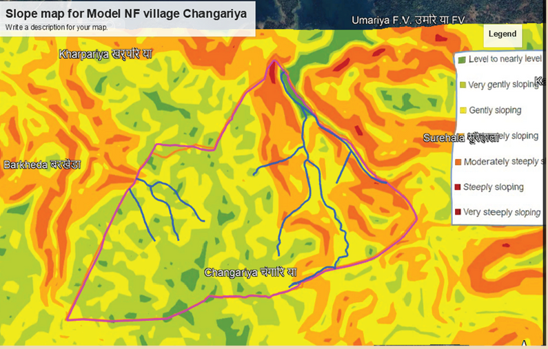
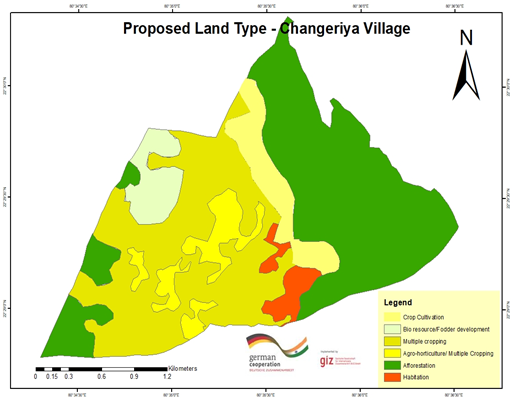
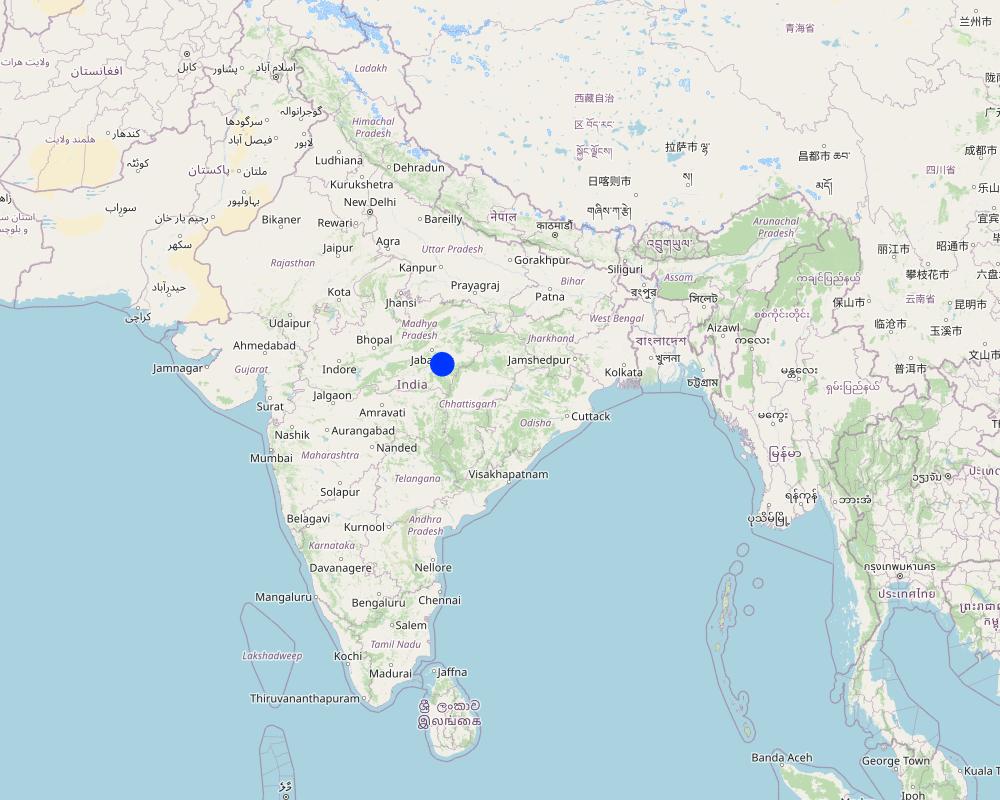
Changariya village, Bichiya block,
Commentaires:
The Changariya village is a sample site to understand the E-prakriti workbook approach
Map
×2.6 Dates de début et de fin de l'Approche
Si l'année précise est inconnue, indiquez approximativement quand l'Approche a démarré:
il y a moins de 10 ans (récemment)
Date (année) de fin de l'Approche (si l'Approche n'est plus appliquée):
2023
Commentaires:
This approach for landscape management considers the landscape as an administrative and natural unit and includes various levels such as Village, Block, District, and geo-hydrological landscapes. It provides a comprehensive activity plan for the management of natural resources, with a focus on natural farming as a core component. The approach is easy to understand and can be used for project implementation.
2.7 Type d'Approche
- fondé sur un projet/ programme
2.8 Principaux objectifs de l'Approche
The objective of this tool is to create a scientific and efficient approach for planning natural farming interventions through the use of GIS-based mapping
2.9 Conditions favorisant ou entravant la mise en œuvre de la(des) Technologie(s) appliquée(s) sous l'Approche
normes et valeurs sociales/ culturelles/ religieuses
- favorise
E-prakriti proposes comprehensive planning by the adequate blending of technology with sustainability approaches, local wisdom, community participation and departmental convergence
cadre institutionnel
- favorise
The effective cooperation of actors like communities, Government Departments and other institutions is enabled by natural-farming planning approaches using GIS Tools.
collaboration/ coordination des acteurs
- favorise
The validation of GIS data is done through on-ground validation and extensive interpretation from maps. Community consultations are crucial in the planning process and convergence planning with the concerned Government Departments is necessary for comprehensive planning. Technical training in basic GIS-based software handling is essential for departmental engineers and other technically competent functionaries.
connaissances sur la GDT, accès aux supports techniques
- favorise
charge de travail, disponibilité de la main-d'œuvre
- favorise
e-Prakriti can significantly reduce the workload of planners and implementers as it reduces the need for physical visits to each and every village to collect ground-level data. A lot of data with very high accuracy can be collected from the satellite-based imaging systems.
3. Participation et rôles des parties prenantes impliquées dans l'Approche
3.1 Parties prenantes impliquées dans l'Approche et rôles
- exploitants locaux des terres / communautés locales
Local community members, farmers
They have provided the data and information during the ground proofing exercises
- organisations communautaires
Local Community - Participation of local groups in implementing the program activities.
Community representatives from villages - support/drive the program's activities.
Community consultations are critical in promoting sustainable development interventions. It is vital to adequately prepare the community for the actions required, and community representatives must be involved at all planning levels, starting from the ground level. The principles of inclusivity and cooperation are crucial in building trust and promoting effective collaboration among community members.
The community's input is essential in creating a suitable action plan and developing maps at the beginning and end of the planning process through larger community consultations. By involving the community in this way, the intervention is more likely to be successful, sustainable and aligned with the community's needs and aspirations. This approach ensures that the community is adequately prepared to undertake the required actions and the intervention is more likely to have a positive impact on the community's well-being in the long run.
- Spécialistes de la GDT/ conseillers agricoles
1. Team from GIZ and consultants who developed the e-Prakriti module
2. Specialist from project implementing team
SLM specialists from GIZ, from the implementing agency, other consultants from the domain of GIS and satellite-based applications have developed the e-Prakriti module. They have looked into the specific requirements for planning the natural farming interventions and available open source platforms to meet that requirement. Once this is developed they also did some ground truthing exercises in the field to observe the accuracy of collected data along with application in the field.
- enseignants/ élèves/ étudiants
Local Community Representative (Community Resource Person)
The CRP is trained to use the E-Prakriti tools for planning natural farming practices. He/she engages with village groups and the program team for planning, implementation and execution. They are considered the most important stakeholders in the process as it is expected that CRPs will use this tool in the planning of their activities.
- ONG
Foundation for Ecological Security (FES) NGO
FES is involved in piloting the approach in villages, handholding for the implementation and monitoring the work. Scaling up plans with different agencies is undertaken once the piloting is successful and evidence is generated.
- gouvernement local
Gram Panchayat (village self governing body)
Liaison with different government departments concerned viz. Departments like Water
Resource, NREGS, Animal Husbandry, Agriculture, Horticulture, Panchayat etc.
Convergence planning is crucial for the successful implementation of natural farming as it extensively relies on the utilization of common natural resources. This can only be achieved through the integrated effort of various concerned Departments, such as Water Resources, NREGS, Animal Husbandry, Agriculture, Horticulture, Panchayat, etc.
Therefore, it is essential to hold joint consultations with these departments to ensure that everyone is on the same page and has a shared understanding of the objectives and strategies for natural farming. These consultations can help to identify the potential areas of collaboration and the specific roles and responsibilities of each department in the implementation of natural farming practices.
In addition to engaging with the relevant departments, it is equally important to involve the district administration in the planning process. The District Collector, CEO of Zila, and Block Panchayat can play a facilitative role in bringing together the various departments and stakeholders involved in natural farming, promoting collaboration and convergence among them.
Through effective convergence planning, it is possible to achieve better coordination and utilization of resources, resulting in improved outcomes for natural farming. This will also contribute to the sustainable development of rural communities and the conservation of natural resources in the long run.
- organisation internationale
Deutsche Gesellschaft für Internationale Zusammenarbeit (GIZ) GmbH
Collated the experiences and prepared the workbook that gives an
overview of planning for natural farming using open-source data
3.2 Participation des exploitants locaux des terres/ communautés locales aux différentes phases de l'Approche
| Participation des exploitants locaux des terres/ communautés locales | Spécifiez qui était impliqué et décrivez les activités | |
|---|---|---|
| initiation/ motivation | passive | They have been discussed to understand their specific needs, resources availability and applications for developing the basic understanding |
| planification | interactive | Local community institutions were involved in the process of planning to understand the local cost specifications, local cropping patterns and to collect and validate the data points |
| mise en œuvre | auto-mobilisation | Local community institutions did implement the interventions with technical guidance from the project implementing team |
| suivi/ évaluation | interactive | During the monitoring process images and data points collected from the satellites were physically validated from the community members. Also, discussions are held with communities to understand the social and economic impact of the project interventions. |
3.3 Diagramme/ organigramme (si disponible)

Description:
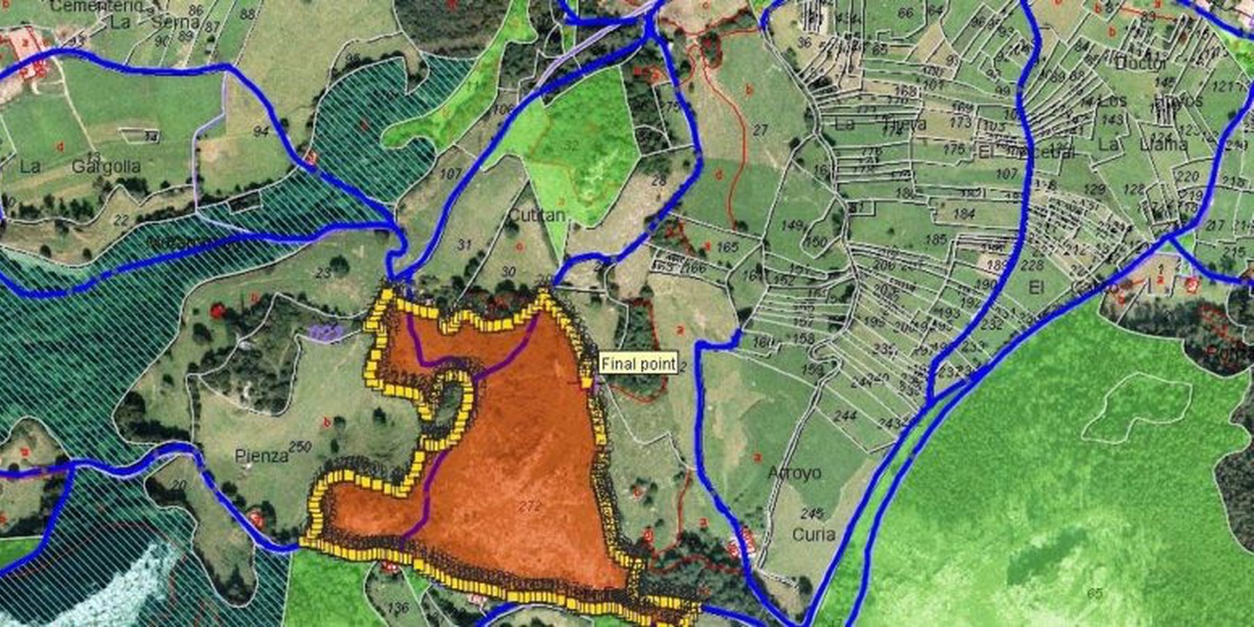
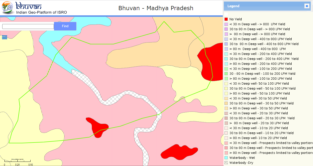
In order to effectively plan for natural farming using GIS tools, it is important to involve the larger systems around the community and the community itself. The first step is to identify and define a unit of intervention, such as a village. Open-source satellite data can then be used to understand and estimate various factors such as geomorphology and geohydrology. This data can be complemented with other available data from sources such as the Ground Water Board or the NREGS portal.
Using QGIS tool, the various data sets can be superimposed to find relationships between them. On-ground validation (truthing) of the GIS data is also necessary to ensure its accuracy. Once the data sets are gathered, an extensive interpretation from maps is undertaken, and the data is translated into easily understandable and implementable material for the community.
Community consultations are a critical part of the intervention, with community representatives being involved at all levels of planning. Inclusivity and cooperation are key principles in engaging the community and government departments and institutions for the judicious use of common resources. Larger community consultations are held at the beginning and end of the planning process to arrive at a suitable action plan using the prepared maps.
The planned actions and locations are plotted on maps on Google Earth, and convergence planning is necessary for the integrated efforts of several concerned departments. Joint consultations are held with these departments, and the district administration can play a facilitative role in bringing everyone on the same page. Lastly, it is important to train departmental engineers, Rozgar Sahayaks, and other technically competent functionaries in basic GIS-based software such as Bhuvan, QGIS, India-WRIS, and Bhuvan Panchayat to extract necessary data.
Auteur:
Deutsche Gesellschaft für Internationale Zusammenarbeit (GIZ) GmbH
3.4 Prises de décision pour la sélection de la Technologie/ des Technologies
Indiquez qui a décidé de la sélection de la Technologie/ des Technologies à mettre en œuvre:
- tous les acteurs concernés dans le cadre d'une approche participative
Spécifiez sur quelle base ont été prises les décisions:
- les résultats de recherches?
- expériences et opinions personnelles (non documentées)
4. Soutien technique, renforcement des capacités et gestion des connaissances
4.1 Renforcement des capacités/ formation
Une formation a-t-elle été dispensée aux exploitants des terres/ autres parties prenantes?
Oui
Spécifiez qui a été formé:
- personnels/ conseillers de terrain
Si pertinent, spécifiez le genre, l'âge, le statut, l'ethnie, etc.
The Community resource person is trained on different maps and related interpretations. The first level of planning is made using open GIS sources which are later validated by the CRP along with the community in the village. Once the plan is finalized in a participatory manner, the program is implemented and monitored using the GIS tool.
Formats de la formation:
- sur le tas
- zones de démonstration
- cours
Thèmes abordés:
1 Village boundaries
2 Village Assets and Infrastructure
3 Watershed / Sub-basin Map
4 Natural Drainage line
8 Availability of groundwater
5 Further resources on Water
5 Geomorphology
6 Slopes within the topography
7 Lineaments- cracks in the land for the generation of aquifiers
8 Soil Erosion
10 Soil kinds/data
11 Land usage pattern
12 Crop season land
13 Wastelands Map
Commentaires:
E-Prakriti is a training module which can be used by various stakeholders for the training and handholding of field team members.
4.2 Service de conseils
Les exploitants des terres ont-ils accès à un service de conseils?
Oui
Spécifiez si le service de conseils est fourni:
- dans les champs des exploitants?
4.3 Renforcement des institutions (développement organisationnel)
Des institutions ont elles été mises en place ou renforcées par le biais de l'Approche?
- non
4.4 Suivi et évaluation
Le suivi et l'évaluation font ils partie de l'Approche? :
Oui
Commentaires:
This tool can be used for monitoring the project interventions by having the pre- and post-project images from the satellite
Si oui, ce document est-il destiné à être utilisé pour le suivi et l'évaluation?
Non
4.5 Recherche
La recherche a-t-elle fait partie intégrante de l’Approche?
Non
5. Financement et soutien matériel externe
5.1 Budget annuel de la composante GDT de l'Approche
Si le budget annuel précis n'est pas connu, indiquez une fourchette:
- < 2 000
Commentez (par ex. principales sources de financement/ principaux bailleurs de fonds):
The major cost involved is in developing the e-Prakriti module, the cost of which was incurred by the GIZ.
Another important cost component is capacity building of the stakeholders.
5.2 Soutiens financiers/ matériels fournis aux exploitants des terres
Les exploitants des terres ont-ils reçu un soutien financier/ matériel pour la mise en œuvre de la Technologie/ des Technologies?
Non
5.3 Subventions pour des intrants spécifiques (incluant la main d'œuvre)
- aucun
5.4 Crédits
Des crédits ont-ils été alloués à travers l'Approche pour les activités de GDT?
Non
5.5 Autres incitations ou instruments
D'autres incitations ou instruments ont-ils été utilisés pour promouvoir la mise en œuvre des Technologies de GDT?
Oui
Si oui, spécifiez:
Training and handholding of stakeholders
6. Analyses d'impact et conclusions
6.1 Impacts de l'Approche
Est-ce que l'Approche a autonomisé les exploitants locaux des terres, amélioré la participation des parties prenantes?
- Non
- Oui, un peu
- Oui, modérément
- Oui, beaucoup
The targeted areas that specifically needed conservation work were focused on
Est-ce que l'Approche a permis la prise de décisions fondées sur des données probantes?
- Non
- Oui, un peu
- Oui, modérément
- Oui, beaucoup
This has been the most important purpose of this approach. The use of various spatial tools ensured evidence-based decision-making
Est-ce que l'Approche a aidé les exploitants des terres à mettre en œuvre et entretenir les Technologies de GDT?
- Non
- Oui, un peu
- Oui, modérément
- Oui, beaucoup
The approach may be a great tool for effective and efficient natural farming-based practices and other SLM technologies
Est-ce que l'Approche a amélioré la coordination et la mise en œuvre de la GDT selon un bon rapport coût-efficacité?
- Non
- Oui, un peu
- Oui, modérément
- Oui, beaucoup
Yes. It has been of great use
Est-ce que l'Approche a mobilisé/ amélioré l'accès aux ressources financières pour la mise en œuvre de la GDT?
- Non
- Oui, un peu
- Oui, modérément
- Oui, beaucoup
Developing projects using the technology has ensured effective financial planning for the planned interventions
Est-ce que l'Approche a amélioré les connaissances et les capacités des exploitants des terres pour mettre en œuvre la GDT?
- Non
- Oui, un peu
- Oui, modérément
- Oui, beaucoup
Land users and local community resource persons learned about the various tools and technologies available for scientific planning
Est-ce que l'Approche a amélioré les connaissances et les capacités des autres parties prenantes?
- Non
- Oui, un peu
- Oui, modérément
- Oui, beaucoup
Community resource persons
Est-ce que l'Approche a construit/ renforcé les institutions, la collaboration entre parties prenantes?
- Non
- Oui, un peu
- Oui, modérément
- Oui, beaucoup
Stakeholders like farmers, FPOs, local community resource persons, NGOs, Government institutions all are in a position to apply a coordinated approach by using this tool
Est-ce que l'Approche a atténué les conflits?
- Non
- Oui, un peu
- Oui, modérément
- Oui, beaucoup
Better mapping of resources could mitigate some conflicts among the community members
Est-ce que l'Approche a amélioré l'égalité entre hommes et femmes et autonomisé les femmes et les filles?
- Non
- Oui, un peu
- Oui, modérément
- Oui, beaucoup
The promotion of natural farming empowers women members as they are core to it. Families get an access to safe and healthy foods as well.
Est-ce que l'Approche a encouragé les jeunes/ la prochaine génération d'exploitants des terres à s'engager dans la GDT?
- Non
- Oui, un peu
- Oui, modérément
- Oui, beaucoup
Est-ce que l'Approche a conduit à l'utilisation/ sources d'énergie plus durables?
- Non
- Oui, un peu
- Oui, modérément
- Oui, beaucoup
Est-ce que l'Approche a amélioré la capacité des exploitants des terres à s'adapter aux changements/ extrêmes climatiques et a atténué les catastrophes liées au climat?
- Non
- Oui, un peu
- Oui, modérément
- Oui, beaucoup
6.2 Principale motivation des exploitants des terres pour mettre en œuvre la GDT
- réduire la charge de travail
The approach reduces the work load during the planning and monitoring stages
- conscience environnementale
Natural farming, watershed management, efficient use of the resources
- améliorer les connaissances et compétences en GDT
6.3 Durabilité des activités de l'Approche
Les exploitants des terres peuvent-ils poursuivre ce qui a été mis en œuvre par le biais de l'Approche (sans soutien extérieur)?
- oui
Si oui, décrivez de quelle manière:
The approach developed is a guidebook, which can be used by anyone using the available open-access platform which is free to use
6.4 Points forts/ avantages de l'Approche
| Points forts/ avantages/ possibilités du point de vue de l'exploitant des terres |
|---|
| Efficient mapping of the resources available to different stakeholders which sometimes community members may not be aware of |
| Convergence opportunities with different line departments once resources are mapped and activities are finalised |
| Reduced workload of the community members and their institutions as they need not be physically present every time |
| Points forts/ avantages/ possibilités du point de vue du compilateur ou d'une autre personne ressource clé |
|---|
| Scientific and evidence based method of planning with a lot of saving in time and resources with better accuracy. Sometimes connecting with communities as well as visiting field areas take a lot of time. |
| The approach can also be used for developing the financial outlays for the shortlisted interventions by getting the physical inputs, conducting the assessments through images and maps collected from open access platforms |
| The e-Prakriti approach can be very effective in the monitoring of the project interventions as satellite-based maps of pre- and post-interventions or geotagged images may provide scientific evidences |
6.5 Faiblesses/ inconvénients de l'Approche et moyens de les surmonter
| Faiblesses/ inconvénients/ risques du point de vue de l’exploitant des terres | Comment peuvent-ils être surmontés? |
|---|---|
| Not much exposed to this approach for planning | Handholding through demonstrations |
| Availability of computer devices to access the maps | Although computers are available at affordable prices in some cases, there may be financial support from the project or government agencies |
| Faiblesses/ inconvénients/ risques du point de vue du compilateur ou d'une autre personne ressource clé | Comment peuvent-ils être surmontés? |
|---|---|
| Technology keeps on updating thus the users need to update and upgrade themselves to ensure the usages at ground | Regular training and handholding of the users either physically or remotely |
| Availability of high speed internet for using the platforms; Currently most land users and CRPs do use internet using their mobile hotspots, access to wi-fi may may not be there | Identified planners or CRPs can be provided with internet devices or they can be linked with Wi-Fi available at different Government bodies |
7. Références et liens
7.1 Méthodes/ sources d'information
- interviews/ entretiens avec les spécialistes/ experts de GDT
2
- compilation à partir de rapports et d'autres documents existants
2
7.3 Liens vers les informations pertinentes disponibles en ligne
Titre/ description:
e-Prakriti for comprehensive planning of natural farming practices
URL:
Physical copy shared by GIZ
Liens et modules
Développer tout Réduire toutLiens
Aucun lien
Modules
Aucun module trouvé