Multi-specific plantation of semiarid woody species on slopes [Espagne]
- Création :
- Mise à jour :
- Compilateur : Susana Bautista
- Rédacteur : matteo jucker riva
- Examinateurs : Fabian Ottiger, Alexandra Gavilano
Plantación pluriespecífica de especies leñosas de ambiente semiárido en laderas
technologies_1618 - Espagne
Voir les sections
Développer tout Réduire tout1. Informations générales
1.2 Coordonnées des personnes-ressources et des institutions impliquées dans l'évaluation et la documentation de la Technologie
Spécialiste GDT:
Guixot Lorena
Universidad de Alicante
Espagne
Spécialiste GDT:
Urgeghe Anna Maria
Universidad de Alicante
Espagne
Governement official:
Bartual Miguel
Conselleria de infrastructuras, territorio y medioambiente
Espagne
Nom du projet qui a facilité la documentation/ l'évaluation de la Technologie (si pertinent)
Catastrophic shifts in drylands (EU-CASCADE)Nom du ou des institutions qui ont facilité la documentation/ l'évaluation de la Technologie (si pertinent)
Universidad de Alicante (Universidad de Alicante) - EspagneNom du ou des institutions qui ont facilité la documentation/ l'évaluation de la Technologie (si pertinent)
Conselleria de infrastructuras, territorio y medioambiente - Espagne1.3 Conditions relatives à l'utilisation par WOCAT des données documentées
Le compilateur et la(les) personne(s) ressource(s) acceptent les conditions relatives à l'utilisation par WOCAT des données documentées:
Oui
2. Description de la Technologie de GDT
2.1 Courte description de la Technologie
Définition de la Technologie:
Plantation of native woody species using planting holes on slopes
2.2 Description détaillée de la Technologie
Description:
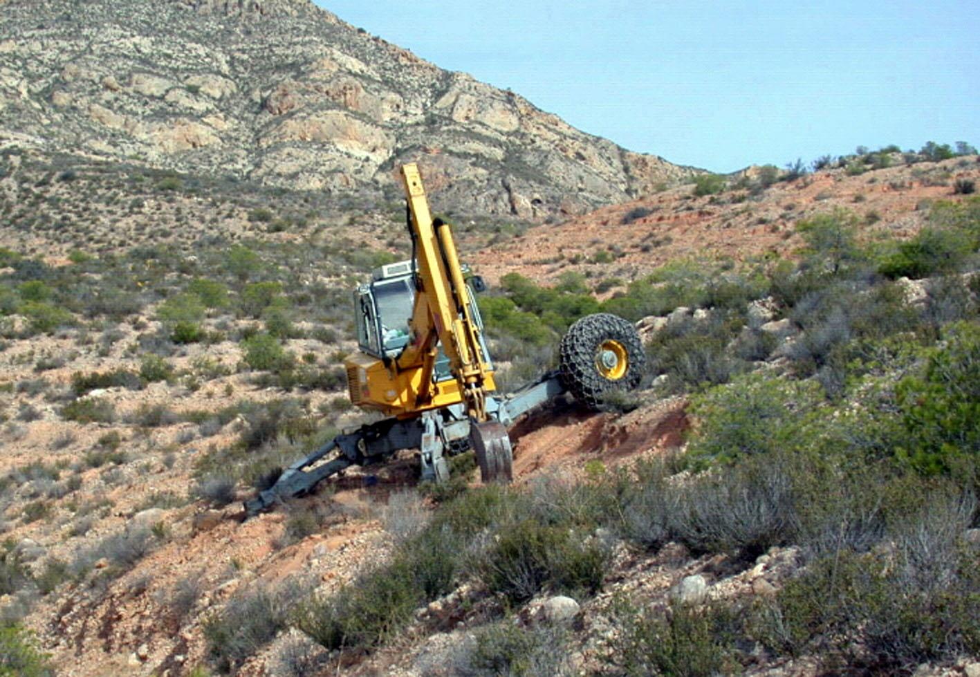
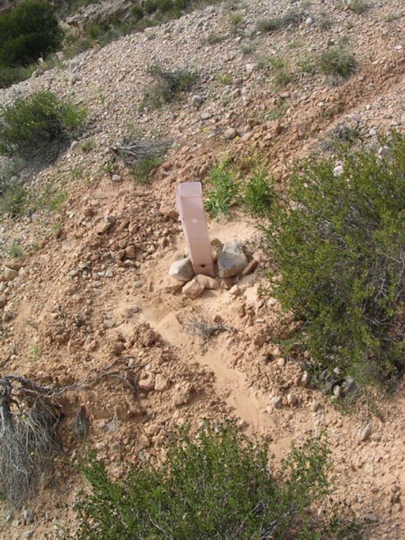
This technology is a restauration technology implemented on degraded south-facing slopes of a semiarid mountain range. The restoration technology consisted of a plantation of seedlings of a variety of native woody species, mostly shrubs, using deep (60cm depth) planting holes. Microcatchments were established upslope the planting hole in suitable areas. Seedlings were protected from extreme radiation and predation by biodegradable seedling shelters. The target area was highly degraded due to long-term overexploitation of resources under harsh environmental conditions. Failed previous reforestation actions on bench terraces led to further degradation in some areas. Degradation resulted in low plant cover, decreased plant biodiversity, lack of riparian vegetation on the ramblas (ravines with intermittent flow), soil erosion, development of gullies, and frequent floods. To address this problem, the Forest Administration implemented a restoration program on the south-facing slopes of the Albatera-Crevillente mountain range. The program was implemented in 2006-07.
Purpose of the Technology: The purpose of the plantation is the restoration of diversity and cover of vegetation on degraded south-facing slopes of a semiarid mountain range, erosion control, and flood prevention.
Natural / human environment: The target area is the south-facing side of a mountain range in a semiarid area of Southeast Spain. Exploitation of resources over centuries, mostly grazing and wood gathering, under harsh environmental conditions, led to very low plant cover, mostly consisting of dwarf shrubs sparsed in a matrix of bare soil, lack of riparian vegetation on the ramblas (ravines with intermittent flow), soil erosion, development of gullies, and frequent floods. The exploitation of the land was drastically reduced during the second half of the 20th century due to the general rural land abandonment trend that started in Spain around the 1950’s driven by critical socio-economic changes such as the use of fossil fuels and the sharp increase in activity in the tourism and services business sectors, mostly in the coast land. However, despite the reduction, or even complete abandonment, of rural activity on the mountain range area, there was no sign of spontaneous recovery from degradation. Soil erosion and floods were of major concern for the resource managers in the area (Public Forest Administration), and a number of reforestation and restoration programs have been implemented in the area, with varying degree of success. In more recent decades, new pressures appeared in the mountain area, such as agricultural expansion into the range area (1970s), mining activities (late 1990’s - early 2000’s), and urbanization (2000s). Rural tourism and recreation are new activities in the mountain range area. For the time being, the intensity of these activities is low to moderate. However there is already some evidence of incipient degradation associated to recreation, and some regulation is being demanded by environmental NGOs.
2.3 Photos de la Technologie
2.5 Pays/ région/ lieux où la Technologie a été appliquée et qui sont couverts par cette évaluation
Pays:
Espagne
Région/ Etat/ Province:
Spain/Alicante
Autres spécifications du lieu:
Albatera
Commentaires:
Comments:
Total area covered by the SLM Technology is 5.7 km2.
The MST was applied on the south-facing side of Albatera-Crevillente mountain range. The area consisted of a sequence of southeast and southwest-facing slopes with small ravines (barrrancos) in between. The MST was specifically applied to the slopes.
2.6 Date de mise en œuvre de la Technologie
Si l'année précise est inconnue, indiquez la date approximative: :
- il y a moins de 10 ans (récemment)
2.7 Introduction de la Technologie
Spécifiez comment la Technologie a été introduite: :
- par le biais de projets/ d'interventions extérieures
Commentaires (type de projet, etc.) :
The MST was designed by the Forest Administration in the framework of a restoration programme for degraded semiarid lands and incorporated recent scientific findings regarding the technology and species used.
3. Classification de la Technologie de GDT
3.1 Principal(aux) objectif(s) de la Technologie
- réduire, prévenir, restaurer les terres dégradées
- réduire les risques de catastrophes
3.2 Type(s) actuel(s) d'utilisation des terres, là où la Technologie est appliquée

Forêts/ bois
- Olea europaea var sylvestris, Ephedra fragilis, Pistacia lentiscus and Pinus halepensis
Produits et services:
- Loisirs/ tourisme
Commentaires:
Major land use problems (compiler’s opinion): Erosion, water scarcity, low productivity, loss of soil functions (water infiltration, nutrient cycling), low biodiversity, loss of landscape structure
Major land use problems (land users’ perception): Low productivity, aridity, erosion
Plantation forestry: Without exploitation
Forest products and services: nature conservation / protection, recreation / tourism
Future (final) land use (after implementation of SLM Technology): Forests / woodlands: Fp: Plantations, afforestations
Number of growing seasons per year:
1
Specify:
Longest growing period in days: 240Longest growing period from month to month: November-June
3.5 Groupe de GDT auquel appartient la Technologie
- Amélioration de la couverture végétale/ du sol
- mesures en travers de la pente
3.6 Mesures de GDT constituant la Technologie

pratiques végétales
- V1: Couverture d’arbres et d’arbustes

structures physiques
- S1: Terrasses
Commentaires:
Main measures: vegetative measures
3.7 Principaux types de dégradation des terres traités par la Technologie

érosion hydrique des sols
- Wt: perte de la couche superficielle des sols (couche arable)/ érosion de surface
- Wo: effets hors-site de la dégradation

dégradation biologique
- Bc: réduction de la couverture végétale
- Bq: baisse de la quantité/ biomasse
- Bs: baisse de la qualité et de la composition/ diversité des espèces

dégradation hydrique
- Ha: aridification
Commentaires:
Main type of degradation addressed: Wt: loss of topsoil / surface erosion, Wo: offsite degradation effects, Bc: reduction of vegetation cover, Bq: quantity / biomass decline, Bs: quality and species composition /diversity decline
Secondary types of degradation addressed: Ha: aridification
Main causes of degradation: deforestation / removal of natural vegetation (incl. forest fires) (Agricultural land expansion. Starting in 1965, peaking in late 1970’s), over-exploitation of vegetation for domestic use (Peaking during 1940’s), poverty / wealth (Poverty)
Secondary causes of degradation: overgrazing (Peaking during 1940’s), industrial activities and mining (Late 1990’s - early 2000’s), urbanisation and infrastructure development (Last 10 years), droughts, population pressure (Relative demographic pressure given the low productivity of the land), land tenure (Lack of proper land demarcation until late 1990’s - early 2000’s, leading to misuse and mismanagement of public land)
3.8 Prévention, réduction de la dégradation ou réhabilitation des terres dégradées
Commentaires:
Main goals: rehabilitation / reclamation of denuded land
Secondary goals: prevention of land degradation, mitigation / reduction of land degradation
4. Spécifications techniques, activités, intrants et coûts de mise en œuvre
4.1 Dessin technique de la Technologie
Spécifications techniques (associées au dessin technique):
Test
Location: Test. Test
Date: Test
Technical knowledge required for field staff / advisors: moderate (Needed for field implementation: soil preparation, planting techniques)
Technical knowledge required for land users: high (Forest Administration staff: High technical knowledge is required for the design of technology implementation)
Main technical functions: control of dispersed runoff: retain / trap, improvement of ground cover, increase in nutrient availability (supply, recycling,…)
Secondary technical functions: control of raindrop splash, control of dispersed runoff: impede / retard, control of concentrated runoff: retain / trap, increase of surface roughness, improvement of surface structure (crusting, sealing), improvement of topsoil structure (compaction), stabilisation of soil (eg by tree roots against land slides), increase in organic matter, increase of infiltration, increase / maintain water stored in soil, sediment retention / trapping, sediment harvesting, increase of biomass (quantity), promotion of vegetation species and varieties (quality, eg palatable fodder), spatial arrangement and diversification of land use
Vegetative measure: Staggered pattern
Vegetative material: T : trees / shrubs
Number of plants per (ha): 610
Spacing between rows / strips / blocks (m): 5
Vertical interval within rows / strips / blocks (m): 5
Vegetative measure: Vegetative material: T : trees / shrubs
Vegetative measure: Vegetative material: T : trees / shrubs
Vegetative measure: Vegetative material: T : trees / shrubs
Trees/ shrubs species: Olea europaea var sylvestris, Ephedra fragilis, Pistacia lentiscus and Pinus halepensis
Auteur:
Test, Test
4.2 Informations générales sur le calcul des intrants et des coûts
autre/ monnaie nationale (précisez):
Euro
Indiquez le taux de change des USD en devise locale, le cas échéant (p.ex. 1 USD = 79.9 réal brésilien): 1 USD = :
0,78
4.3 Activités de mise en place/ d'établissement
| Activité | Calendrier des activités (saisonnier) | |
|---|---|---|
| 1. | Soil preparation and planting holes | during winter |
| 2. | Soil and microcatchment preparation | during winter |
| 3. | Fertilization plantation (holes) | Winter |
| 4. | Fertilization microcatchment | Winter |
| 5. | Plantation | during winter |
| 6. | Plantation (microcatchments) | during winter |
| 7. | Tree shelter placement | late winter |
| 8. | tree shelter placement (Microcatchments) | late winter |
4.4 Coûts et intrants nécessaires à la mise en place
| Spécifiez les intrants | Unité | Quantité | Coûts par unité | Coût total par intrant | % des coût supporté par les exploitants des terres | |
|---|---|---|---|---|---|---|
| Main d'œuvre | Labour | ha | 1,0 | 1343,0 | 1343,0 | 100,0 |
| Equipements | Machine use | ha | 1,0 | 853,0 | 853,0 | 100,0 |
| Matériel végétal | Seedlings | ha | 1,0 | 252,0 | 252,0 | 100,0 |
| Engrais et biocides | Biocides | ha | 1,0 | 154,0 | 154,0 | 100,0 |
| Autre | Tree shelters | ha | 1,0 | 424,0 | 424,0 | 100,0 |
| Coût total de mise en place de la Technologie | 3026,0 | |||||
| Coût total de mise en place de la Technologie en dollars américains (USD) | 3879,49 | |||||
Commentaires:
Duration of establishment phase: 5 month(s)
4.6 Coûts et intrants nécessaires aux activités d'entretien/ récurrentes (par an)
Commentaires:
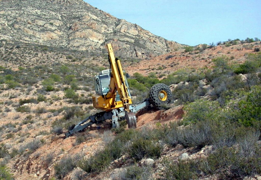
Machinery/ tools: Walking Excavator
5. Environnement naturel et humain
5.1 Climat
Précipitations annuelles
- < 250 mm
- 251-500 mm
- 501-750 mm
- 751-1000 mm
- 1001-1500 mm
- 1501-2000 mm
- 2001-3000 mm
- 3001-4000 mm
- > 4000 mm
Spécifications/ commentaires sur les précipitations:
280 mm (mean 1958 – 2007) Rainy seasons: spring and autumn
Zone agro-climatique
- semi-aride
Thermal climate class: subtropics
5.2 Topographie
Pentes moyennes:
- plat (0-2 %)
- faible (3-5%)
- modéré (6-10%)
- onduleux (11-15%)
- vallonné (16-30%)
- raide (31-60%)
- très raide (>60%)
Reliefs:
- plateaux/ plaines
- crêtes
- flancs/ pentes de montagne
- flancs/ pentes de colline
- piémonts/ glacis (bas de pente)
- fonds de vallée/bas-fonds
Zones altitudinales:
- 0-100 m
- 101-500 m
- 501-1000 m
- 1001-1500 m
- 1501-2000 m
- 2001-2500 m
- 2501-3000 m
- 3001-4000 m
- > 4000 m
Indiquez si la Technologie est spécifiquement appliquée dans des:
- non pertinent
5.3 Sols
Profondeur moyenne du sol:
- très superficiel (0-20 cm)
- superficiel (21-50 cm)
- modérément profond (51-80 cm)
- profond (81-120 cm)
- très profond (>120 cm)
Texture du sol (de la couche arable):
- grossier/ léger (sablonneux)
- moyen (limoneux)
Matière organique de la couche arable:
- moyen (1-3%)
Si disponible, joignez une description complète du sol ou précisez les informations disponibles, par ex., type de sol, pH/ acidité du sol, capacité d'échange cationique, azote, salinité, etc.
Soil texture is medium (Sandy- loam (dominant))
Soil fertility is low
Soil drainage/infiltration is good
Soil water storage capacity is medium
5.4 Disponibilité et qualité de l'eau
Profondeur estimée de l’eau dans le sol:
> 50 m
Disponibilité de l’eau de surface:
faible/ absente
Qualité de l’eau (non traitée):
uniquement pour usage agricole (irrigation)
Commentaires et précisions supplémentaires sur la qualité et la quantité d'eau:
Water quality (untreated): For agricultural use only (irrigation)(groundwater)
5.5 Biodiversité
Diversité des espèces:
- moyenne
5.6 Caractéristiques des exploitants des terres appliquant la Technologie
Revenus hors exploitation:
- > 50% de tous les revenus
Individus ou groupes:
- employé (entreprise, gouvernement)
Genre:
- femmes
- hommes
Indiquez toute autre caractéristique pertinente des exploitants des terres:
Land users applying the Technology are mainly Leaders / privileged
Population density: 100-200 persons/km2
Annual population growth: 2% - 3%
Market orientation of production system: No forestry production
5.7 Superficie moyenne des terres utilisées par les exploitants des terres appliquant la Technologie
- < 0,5 ha
- 0,5-1 ha
- 1-2 ha
- 2-5 ha
- 5-15 ha
- 15-50 ha
- 50-100 ha
- 100-500 ha
- 500-1 000 ha
- 1 000-10 000 ha
- > 10 000 ha
Cette superficie est-elle considérée comme de petite, moyenne ou grande dimension (en se référant au contexte local)?
- grande dimension
Commentaires:
Public land
5.8 Propriété foncière, droits d’utilisation des terres et de l'eau
Propriété foncière:
- état
Droits d’utilisation des terres:
- accès libre (non organisé)
5.9 Accès aux services et aux infrastructures
santé:
- pauvre
- modéré
- bonne
éducation:
- pauvre
- modéré
- bonne
assistance technique:
- pauvre
- modéré
- bonne
emploi (par ex. hors exploitation):
- pauvre
- modéré
- bonne
marchés:
- pauvre
- modéré
- bonne
énergie:
- pauvre
- modéré
- bonne
routes et transports:
- pauvre
- modéré
- bonne
eau potable et assainissement:
- pauvre
- modéré
- bonne
services financiers:
- pauvre
- modéré
- bonne
6. Impacts et conclusions
6.1 Impacts sur site que la Technologie a montrés
Impacts socioculturels
possibilités de loisirs
connaissances sur la GDT/ dégradation des terres
Improved livelihoods and human well-being
Commentaires/ spécifiez:
Recreational use
Impacts écologiques
Cycle de l'eau/ ruissellement
récolte/ collecte de l'eau
ruissellement de surface
évaporation
Sols
humidité du sol
couverture du sol
perte en sol
cycle/ recharge des éléments nutritifs
matière organique du sol/ au dessous du sol C
Biodiversité: végétale, animale
biomasse/ au dessus du sol C
diversité végétale
diversité animale
espèces bénéfiques
diversité des habitats
6.2 Impacts hors site que la Technologie a montrés
inondations en aval
6.3 Exposition et sensibilité de la Technologie aux changements progressifs et aux évènements extrêmes/catastrophes liés au climat (telles que perçues par les exploitants des terres)
Changements climatiques progressifs
Changements climatiques progressifs
| Saison | Augmentation ou diminution | Comment la Technologie fait-elle face à cela? | |
|---|---|---|---|
| températures annuelles | augmente | bien |
Extrêmes climatiques (catastrophes)
Catastrophes météorologiques
| Comment la Technologie fait-elle face à cela? | |
|---|---|
| pluie torrentielle locale | pas bien |
| tempête de vent locale | pas connu |
Catastrophes climatiques
| Comment la Technologie fait-elle face à cela? | |
|---|---|
| sécheresse | pas bien |
Catastrophes hydrologiques
| Comment la Technologie fait-elle face à cela? | |
|---|---|
| inondation générale (rivière) | pas connu |
Autres conséquences liées au climat
Autres conséquences liées au climat
| Comment la Technologie fait-elle face à cela? | |
|---|---|
| réduction de la période de croissance | bien |
6.4 Analyse coûts-bénéfices
Quels sont les bénéfices comparativement aux coûts de mise en place (du point de vue des exploitants des terres)?
Rentabilité à court terme:
légèrement négative
Rentabilité à long terme:
positive
7. Références et liens
7.1 Méthodes/ sources d'information
Liens et modules
Développer tout Réduire toutLiens
Aucun lien
Modules
Aucun module trouvé


