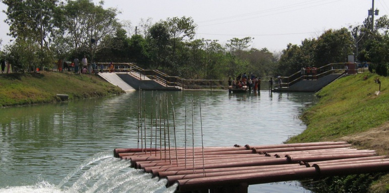
Water from the Padma river lifted to the Sharmangla canal for irrigation (Zillul Bari)

Mainstreaming river water to facilitate irrigation in Barind (ບັງລາເດດ)

Sharmongla Sech Prokolpo.

ຄຳອະທິບາຍ

The technology promotes the lifting of river water by pump sets and conveys the water through buried pipelines to a canal. The conserved canal water is used for irrigation delivered by low lift pumps (LLP). Because water is held in the canal it revitalises the ecosystem along its length. Furthermore, using river water for irrigation avoids dangers associated with groundwater depletion.

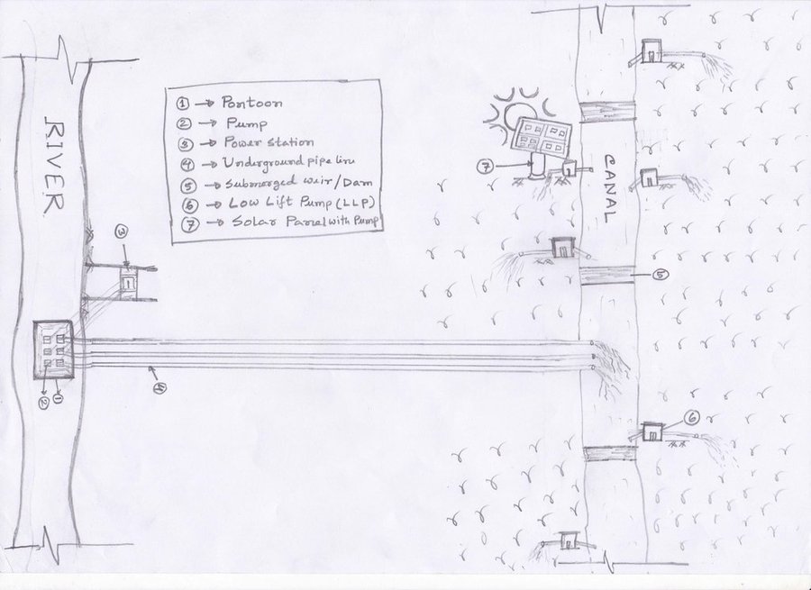
The project is sited at Sharmongla under Godagari Upazilla of Rajshahi district. The Sharmongla canal is located about 3.5 km away from the Padma river. Its total length is 29.0 km. Under this technology, water is lifted from the Padma river by pumps set on a pontoon. The lifted water is then discharged to a canal through underground pipelines. The water so discharged is lifted to the crop fields (delivery points) for irrigation. The elevation difference between the delivery points and the sourcing river is about 21 m. There are numbers of submerged weirs/dams constructed across the canal at different locations for conserving water: the water then helps regenerate the ecosystem along its banks and enriches the habitat.
Pontoon at a glance:
•Year of construction: 2004
•No. of centrifugal pumps at pontoon: 12
•Pump capacity: 50 m lifting height.
•Power of each pump: 60 HP
•Capacity of each pump: 2.5 cusec
•Total capacity of pump sets: 30 cusec
•Capacity of electric sub-station: 750 KW
•No. of discharge pipelines: 12

Sharmongla canal at a glance:
•Length of the canal: 29 km
•Average width of the canal: 15 m
•Average depth from ground level: 5 m
•No. of submerged weirs and dams within the canal: 14
•No. of LLP (low lift pump): 27 electrified and 6 solar pumps
•Total irrigated area: 1850 ha
•Benefiting farmers: 5330
•Harvest yield of rice per year: 20,500 metric tonnes (approx.)
•Afforestation on the canal bank: 65,500 trees

Purposes/objectives of the technology:
•The main purpose of the said technology is to provide water for irrigation. This prevents abstracting of groundwater, which has adverse effects on the environment: therefore this system is environment friendly.
• Enhancing groundwater recharge thereby supports ecosystem function.
•The storing of river water in irrigation canals supports the enrichment of the habitat.

Approach for implementing the technology:
There was no irrigation facility for crop production in this drought-prone area. Government officials came to the locality, discussed with the local community, elites, as well as the farmers. Finally, the local community was convinced about the technology. Then the irrigation system could be implemented in the area. On seeing the success of the technology, the same has been replicated on approx. 9400 ha. in Barind area, benefitting approx. 32,200 farmers.

Maintenance of the technology:
In case of problems, the respective mechanic of that area informs the Assistant Engineer through the Sub-Assistant Engineer. Thus the problem is solved by their own initiative. It is also monitored by the Executive Engineer of the respective District, and finally by the Executive Director from the headquarters if needed.

Crop cultivation:
Due to the application of the technology, previously fallow land has come under cultivation/irrigation facilities, mono-cropped land has been converted into multi-cropped land. Different crops, like rice, wheat, maize, mustard, pulses, potato, tomato, spices and other vegetables are cultivated.

Farmers’ acceptance:
The technology has been well accepted by the farmers, as uncultivated land has been brought under cultivation and different crops are now being cultivated year-round.
ສະຖານທີ່

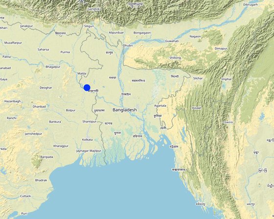
ສະຖານທີ່: ບັງລາເດດ

ຈໍານວນ ພື້ນທີ່ ທີ່ໃຊ້ ເຕັກໂນໂລຢີ ທີ່ໄດ້ວິເຄາະ: 2-10 ພຶ້ນທີ່

ການຄັດເລືອກພື້ນທີ່ ທີ່ອີງໃສ່ຂໍ້ມູນທາງພູມີສາດ
  • 88.34248, 24.48567

ການແຜ່ກະຈາຍຂອງເຕັກໂນໂລຢີ: ນໍາໃຊ້ໃນຈຸດສະເພາະ / ແນໃສ່ນໍາໃຊ້ໃນພື້ນທີ່ຂະໜາດນ້ອຍ

ຢູ່ໃນເຂດປ່າສະຫງວນທີ່ບໍ?: ບໍ່ແມ່ນ

ວັນທີຂອງການປະຕິບັດ: 10-50 ປີ ຜ່ານມາ

ປະເພດຂອງການນໍາສະເໜີ
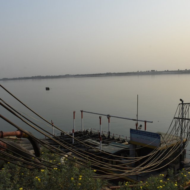
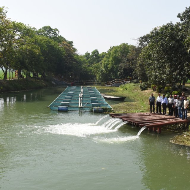
Pontoon with pumps at Padma river; there are 12 pumps operating (Zillul Bari)
Water in the Sharmangla river (Zillul Bari)

ການໄຈ້ແຍກເຕັກໂນໂລຢີ

ຈຸດປະສົງຕົ້ນຕໍ
  • ປັບປຸງ ການຜະລິດ
  • ຫຼຸດຜ່ອນ, ປ້ອງກັນ, ຟື້ນຟູ ການເຊື່ອມໂຊມຂອງດິນ
  • ການອະນຸລັກ ລະບົບນິເວດ
  • ປົກປັກຮັກສານໍ້າ / ນໍ້າພື້ນທີ່ - ປະສົມປະສານກັບ ເຕັກໂນໂລຢີອື່ນໆ
  • ປົກປັກຮັກສາ / ການປັບປຸງຊີວະນາໆພັນ
  • ຫຼຸດຜ່ອນຄວາມສ່ຽງ ທາງໄພພິບັດທໍາມະຊາດ
  • ປັບຕົວຕໍ່ກັບການປ່ຽນແປງດິນຟ້າອາກາດ / ທີ່ຮ້າຍແຮງ ແລະ ຜົນກະທົບ
  • ຫຼຸດຜ່ອນຜົນກະທົບ ຈາກການປ່ຽນແປງດິນຟ້າອາກາດ
  • ສ້າງຜົນກະທົບ ທາງເສດຖະກິດ ທີ່ເປັນປະໂຫຍດ
  • ສ້າງຜົນກະທົບ ທີ່ເປັນທາງບວກ ໃຫ້ແກ່ສັງຄົມ
ການນໍາໃຊ້ດິນ
ການນຳໃຊ້ທີ່ດິນ ປະສົມພາຍໃນພື້ນທີ່ດຽວກັນ: ແມ່ນ - ກະສິກໍາ-ປ່າໄມ້ ແບບປະສົມປະສານ

  • ດິນທີ່ປູກພືດ
    • ການປູກພືດປະຈໍາປີ
    • ເປັນໄມ້ຢືນຕົ້ນ ແລະ ໄມ້ພຸ່ມ ຈາກການປູກພືດ: ໝາກມ່ວງ, ໝາກມັງຄຸດ, ໝາກສີດາ
    ຈໍານວນ ລະດູການ ປູກໃນປີໜຶ່ງ: 3
    ມີການເຝືກປູກພືດແບບສັບຫວ່າງບໍ່? ແມ່ນ
    ມີການເຝືກປູກພືດແບບໝູນວຽນບໍ່? ແມ່ນ

ການສະໜອງນໍ້າ
  • ນໍ້າຝົນ
  • ປະສົມປະສານ ກັນລະຫວ່າງ ນໍ້າຝົນ ແລະ ນໍ້າຊົນລະປະທານ
  • ນໍາໃຊ້ ນໍ້າຊົນລະປະທານ ພຽງຢ່າງດຽວ

ຈຸດປະສົງທີ່ກ່ຽວຂ້ອງກັບການເຊື່ອມໂຊມຂອງດິນ
  • ປ້ອງກັນການເຊື່ອມໂຊມຂອງດິນ
  • ຫຼຸດຜ່ອນການເຊື່ອມໂຊມຂອງດິນ
  • ການຟື້ນຟູ / ຟື້ນຟູດິນທີ່ຊຸດໂຊມ
  • ປັບຕົວຕໍ່ການເຊື່ອມໂຊມຂອງດິນ
  • ບໍ່ສາມາດໃຊ້ໄດ້
ການເຊື່ອມໂຊມ ທີ່ຕ້ອງໄດ້ເອົາໃຈໃສ່
  • ການເຊື່ອມໂຊມ ຂອງນໍ້າ - Ha: ສະພາບແຫ້ງແລ້ງ, Hq: ຄຸນນະພາບ ຂອງນ້ຳໃຕ້ດິນຫຼຸດລົງ
ກຸ່ມການຄຸ້ມຄອງທີ່ດິນແບບຍືນຍົງ
  • ກະສິກໍາ-ປ່າໄມ້ ແບບປະສົມປະສານ
  • ການຄຸ້ມຄອງຊົນລະປະທານ (ການສະໜອງນໍ້າ, ລະບາຍ)
  • ການຄຸ້ມຄອງນໍ້າໜ້າດິນ (ນ້ຳຈາກພຸ, ແມ່ນໍ້າ, ທະເລສາບ, ທະເລ)
ມາດຕະການ ການຄຸ້ມຄອງທີ່ດິນແບບຍືນຍົງ
  • ມາດຕະການໂຄງສ້າງ - S3: ຮ່ອງ, ຄອງນໍ້າ, ທາງໄຫຼນໍ້າ, S5: ເຂື່ອນໄຟຟ້າ, ຝາຍເກັບນໍ້າ, ອ່າງ, ໜອງ , S7: ອຸປະກອນເກັບຮັກສາ, ສະໜອງນ້ຳ, ຊົນລະປະທານ, S10: ມາດຕະການ ປະຢັດພະລັງງານ
  • ມາດຕະການ ທາງດ້ານການຄຸ້ມຄອງ - M2: ການປ່ຽນແປງ ການຈັດການຄຸ້ມຄອງ / ລະດັບຄວາມໜາແໜ້ນ, M3: ອີງຕາມສະພາບແວດລ້ອມ ທາງທຳມະຊາດ ແລະ ມະນຸດ

​ເທັກ​ນິກ​ການ​ແຕ້ມ​ຮ​ູບ

​ຂໍ​ກຳ​ນົດ​ທາງ​ເທັກ​ນິກ
1. Pontoon: Length 55 ft, Width: 25 ft, Height: 4.50 ft
2. Centrifugal pump (12 nos)—each pump 60 HP,capacity-2.5 cusec, pump head: 50m
3. Electric power station capacity: 750 KW
4. Underground water distribution line (12 nos): Length of each line is 3.50 km
5. Length of water storage canal (Sharmangla canal): 29.0 km (average width 15.0 m and depth 5.0 m)
6. Nos of submerged weir/dam to reserve water in the canal: 14 nos
7. Nos of LLP (electrified) to lift water from the canal to crop field through buried pipeline : 27 nos
8. Nos of solar pump to lift water from the canal to crop field through buried pipeline: 06 nos
9. Nos of Prepaid meter for collecting irrigation charges (Revenue): 33 nos
10. Irrigated area: 1850 ha
11. Construction materials:
-Pontoon: A kind of platform that float on water made of Mild steel sheet, Stainless steel etc.
- Power station: Transformer, electric pole, wire etc.
- Distribution line: mild steel and PVC pipe
- Dam/Submerged weir: steel bar, cement, sand, brick, stone etc.
Author: Sayed Zillul Bari

ການຈັດຕັ້ງ ແລະ ບໍາລຸງຮັກສາ: ກິດຈະກໍາ, ວັດຖຸດິບ ແລະ ຄ່າໃຊ້ຈ່າຍ

ການ​ຄຳ​ນວນ​ ປັດ​ໃຈ​ການ​ຜະ​ລິດ ແລະ ຄ່າ​ໃຊ້​ຈ່າຍ
  • ຄິດໄລ່ຄ່າໃຊ້ຈ່າຍ: ຕໍ່ຫົວໜ່ວຍ ທີ່ໄດ້ຈັດຕັ້ງປະຕິບັດ ເຕັກໂນໂລຢີ (ຫົວໜ່ວຍ:1 Pontoon, Pumps, Pipes, weir construction etc volume, length: Pontoon (Length 55 ft, Width: 25 ft, Height: 4.50 ft) is a platform build on iron sheets, that can float on river, where pumps were set. The pipes for water delivery were of PVC. Water canal in this case compiler referred to canals of Barind which were ephemeral. Now water reserve for year round use.Piping system includes PVC pipe to convey water to the field, where a valve was set to control water disposal. There is a pipe of 12 inch dia to maintain water head through out the system.)
  • ສະກຸນເງິນທີ່ໃຊ້ສໍາລັບການຄິດໄລ່ຄ່າໃຊ້ຈ່າຍ: BDT
  • ອັດຕາແລກປ່ຽນ (ເປັນເງີນ ໂດລາ): 1 USD = 85.0 BDT
  • ຄ່າແຮງງານສະເລ່ຍ ຂອງການຈ້າງແຮງງານຕໍ່ມື້: 800 BDT
ປັດໄຈທີ່ສໍາຄັນສຸດທີ່​ສົ່ງຜົນກະທົບຕໍ່ຄ່າໃຊ້ຈ່າຍ
Pontoon construction, power supply and lining of the underground piping system.
ກິດຈະກໍາການສ້າງຕັ້ງ
  1. Pontoon construction and installation on the river (ໄລຍະເວລາ / ຄວາມຖີ່: 60 days)
  2. Pumps installation on the pontoon (ໄລຍະເວລາ / ຄວາມຖີ່: 30 days)
  3. Construction of underground water distribution line (ໄລຍະເວລາ / ຄວາມຖີ່: 70 days)
  4. Re-excavation of derelict canal (ໄລຍະເວລາ / ຄວາມຖີ່: 120 days)
  5. Construction of submerged weir / dam (ໄລຍະເວລາ / ຄວາມຖີ່: 180 days)
  6. LLP installation at the canal bank (27 nos) (ໄລຍະເວລາ / ຄວາມຖີ່: 150 days)
  7. Solar pump installation (06 nos) (ໄລຍະເວລາ / ຄວາມຖີ່: 45 days)
  8. Pre-paid meter installation at pump sites to collect irrigation charges (33 nos) (ໄລຍະເວລາ / ຄວາມຖີ່: 30 days)
  9. Buried pipe line construction for irrigation at crop land sites (ໄລຍະເວລາ / ຄວາມຖີ່: 120 days)
ປັດໄຈນໍາເຂົ້າໃນການຈັດຕັ້ງ ແລະ ຄ່າໃຊ້ຈ່າຍ (per 1 Pontoon, Pumps, Pipes, weir construction etc)
ລະບຸ ປັດໃຈ ນໍາເຂົ້າ ໃນການຜະລີດ ຫົວໜ່ວຍ ປະລິມານ ຕົ້ນທຶນ ຕໍ່ຫົວໜ່ວຍ (BDT) ຕົ້ນທຶນທັງໝົດ ຂອງປັດໃຈຂາເຂົ້າ ໃນການຜະລິດ (BDT) % ຂອງຕົ້ນທຶນທັງໝົດ ທີ່ຜູ້ນໍາໃຊ້ທີ່ດິນ ໃຊ້ຈ່າຍເອງ
ວັດສະດຸກໍ່ສ້າງ
Pontoon construction and installation on the river 1 1.0 5000000.0 5000000.0
Construction of underground water distribution line 1 1.0 27800000.0 27800000.0
Construction of submerged weir / dam 1 14.0 1600000.0 22400000.0
Re-excavation of derelict canal 1 1.0 29000000.0 29000000.0
ອື່ນໆ
Pre-paid meter installation at pump sites to collect irrigation charges 1 33.0 243000.0 8019000.0
Solar pump installation 1 6.0 2000000.0 12000000.0
LLP installation at the canal bank (27 nos) 1 8.0 2700000.0 21600000.0
Pumps installation on the pontoon 1 12.0 1833000.0 21996000.0
Buried pipe line construction for irrigation at crop land sites 1 1.0 23100000.0 23100000.0
ຕົ້ນທຶນທັງໝົດ ໃນການຈັດຕັ້ງປະຕິບັດ ເຕັກໂນໂລຢີ 170'915'000.0
ຄ່າໃຊ້ຈ່າຍທັງໝົດ ສຳລັບການສ້າງຕັ້ງເຕັກໂນໂລຢີ ເປັນສະກຸນເງີນໂດລາ 2'010'764.71
ກິດຈະກໍາບໍາລຸງຮັກສາ
  1. Pontoon repair and maintenance (ໄລຍະເວລາ / ຄວາມຖີ່: 1/5years)
  2. Pump repair and maintenance (ໄລຍະເວລາ / ຄວາມຖີ່: As per requirement, 1/yr)
  3. Distribution line maintenance (ໄລຍະເວລາ / ຄວາມຖີ່: As per requirement, 1/yr)
  4. Power station repair and maintenance (ໄລຍະເວລາ / ຄວາມຖີ່: As per requirement, 1/yr)
  5. Submerged weir / dam repair and maintenance (ໄລຍະເວລາ / ຄວາມຖີ່: 1/5yrs)
  6. LLP repair and maintenance (ໄລຍະເວລາ / ຄວາມຖີ່: 2/yr or as and when necessary)
  7. Buried pipe line repair and maintenance (ໄລຍະເວລາ / ຄວາມຖີ່: 1/6yrs, as and when necessary)
  8. Prepaid meter repair (ໄລຍະເວລາ / ຄວາມຖີ່: 2-3/yr)
ປັດໄຈນໍາເຂົ້າໃນການບໍາລຸງຮັກສາ ແລະ ຄ່າໃຊ້ຈ່າຍ (per 1 Pontoon, Pumps, Pipes, weir construction etc)
ລະບຸ ປັດໃຈ ນໍາເຂົ້າ ໃນການຜະລີດ ຫົວໜ່ວຍ ປະລິມານ ຕົ້ນທຶນ ຕໍ່ຫົວໜ່ວຍ (BDT) ຕົ້ນທຶນທັງໝົດ ຂອງປັດໃຈຂາເຂົ້າ ໃນການຜະລິດ (BDT) % ຂອງຕົ້ນທຶນທັງໝົດ ທີ່ຜູ້ນໍາໃຊ້ທີ່ດິນ ໃຊ້ຈ່າຍເອງ
ອຸປະກອນ
Prepaid meter repair 1 0.2 100000.0 20000.0
ວັດສະດຸກໍ່ສ້າງ
Buried pipe line repair and maintenance 1 1.0 0.05 0.05
ອື່ນໆ
Pontoon repair and maintenance 1 1.0 500000.0 500000.0
Pump repair and maintenance (each) 1 1.0 20000.0 20000.0
Distribution line maintenance 1 1.0 75000.0 75000.0
Power station repair and maintenance 1 1.0 50000.0 50000.0
Submerged weir / dam repair and maintenance (each) 1 1.0 200000.0 200000.0
LLP repair and maintenance (each) 1 1.0 50000.0 50000.0
ຕົ້ນທຶນທັງໝົດ ທີ່ໃຊ້ໃນການບໍາລຸງຮັກສາ ເຕັກໂນໂລຢີ 915'000.05
ຄ່າໃຊ້ຈ່າຍທັງໝົດ ສຳລັບການບົວລະບັດຮກສາເຕັກໂນໂລຢີ ເປັນສະກຸນເງີນໂດລາ 10'764.71

ສະພາບແວດລ້ອມທໍາມະຊາດ

ສະເລ່ຍປະລິມານນໍ້າຝົນປະຈໍາປີ
  • < 250 ມີລິແມັດ
  • 251-500 ມີລິແມັດ
  • 501-750 ມີລິແມັດ
  • 751-1,000 ມີລິແມັດ
  • 1,001-1,500 ມີລິແມັດ
  • 1,501-2,000 ມີລິແມັດ
  • 2,001-3,000 ມີລິແມັດ
  • 3,001-4,000 ມີລິແມັດ
  • > 4,000 ມີລິແມັດ
ເຂດກະສິກໍາ-ສະພາບອາກາດ
  • ຄວາມຊຸ່ມ
  • ເຄີ່ງຄວາມຊຸ່ມ
  • ເຄິ່ງແຫ້ງແລ້ງ
  • ແຫ້ງແລ້ງ
ຂໍ້ມູນຈໍາເພາະກ່ຽວກັບສະພາບອາກາດ
ປະລິມານນໍ້າຝົນສະເລ່ຍຕໍ່ປີເປັນມິລິແມັດ: 1600.0
Most of the rainfall events happen during May to October
ຊື່ຂອງສະຖານີອຸຕຸນິຍົມ: Agroecological region 26
​ຄວາມຄ້ອຍ​ຊັນ
  • ພື້ນທີ່ຮາບພຽງ (0-2%)
  • ອ່ອນ (3-5 %)
  • ປານກາງ (6-10 %)
  • ມ້ວນ (11-15 %)
  • ເນີນ(16-30%)
  • ໍຊັນ (31-60%)
  • ຊັນຫຼາຍ (>60%)
ຮູບແບບຂອງດິນ
  • ພູພຽງ / ທົ່ງພຽງ
  • ສັນພູ
  • ເປີ້ນພູ
  • ເນີນພູ
  • ຕີນພູ
  • ຮ່ອມພູ
ລະດັບຄວາມສູງ
  • 0-100 ແມັດ a.s.l.
  • 101-500 ແມັດ a.s.l.
  • 501-1,000 ແມັດ a.s.l.
  • 1,001-1,500 ແມັດ a.s.l.
  • 1,501-2,000 ແມັດ a.s.l.
  • 2,001-2,500 ແມັດ a.s.l.
  • 2,501-3,000 ແມັດ a.s.l.
  • 3,001-4,000 ແມັດ a.s.l.
  • > 4,000 ແມັດ a.s.l.
ເຕັກໂນໂລຢີໄດ້ຖືກນໍາໃຊ້ໃນ
  • ລັກສະນະສວດ
  • ລັກສະນະກີ່ວ
  • ບໍ່ກ່ຽວຂ້ອງ
ຄວາມເລິກຂອງດິນ
  • ຕື້ນຫຼາຍ (0-20 ຊັງຕີແມັດ)
  • ຕື້ນ (21-50 ຊຕມ)
  • ເລີກປານກາງ (51-80 ຊຕມ)
  • ເລິກ (81-120 ຊມ)
  • ເລິກຫຼາຍ (> 120 cm)
ໂຄງສ້າງຂອງດິນ (ເທີງໜ້າດິນ)
  • ຫຍາບ / ເບົາ (ດິນຊາຍ)
  • ປານກາງ (ດິນໜຽວ, ດິນໂຄນ)
  • ບາງລະອຽດ / ໜັກ (ໜຽວ)
ໂຄງສ້າງຂອງດິນ (ເລິກລົງ 20 ຊັງຕີແມັດ)
  • ຫຍາບ / ເບົາ (ດິນຊາຍ)
  • ປານກາງ (ດິນໜຽວ, ດິນໂຄນ)
  • ບາງລະອຽດ / ໜັກ (ໜຽວ)
ທາດອິນຊີຢູ່ເທິງໜ້າດິນ
  • ສູງ (> 3 %)
  • ປານກາງ (1-3 %)
  • ຕໍາ່ (<1 %)
​ນ້ຳ​ໃຕ້​ດິນ
  • ເທິງຊັ້ນໜ້າດິນ
  • < 5 ແມັດ
  • 5-50 ແມັດ
  • > 50 ແມັດ
ມີນໍ້າໜ້າດິນ
  • ເກີນ
  • ດີ
  • ປານກາງ
  • ທຸກຍາກ / ບໍ່ມີ
ຄຸນນະພາບນໍ້າ (ການຮັກສາ)
  • ມີນໍ້າດື່ມ
  • ບໍ່ມີນໍ້າດື່ມ (ຮຽກຮ້ອງໃຫ້ມີການບຳບັດນ້ຳ)
  • ນຳໃຊ້ເຂົ້າໃນການຜະລິດກະສິກໍາພຽງຢ່າງດຽງ (ຊົນລະປະທານ)
  • ຜິດປົກກະຕິ
ຄຸນນະພາບນ້ຳ ໝາຍເຖີງ: ທັງນ້ຳໃຕ້ດິນ ແລະ ນ້ຳໜ້າດິນ
ດິນ​ເຄັມ​ເປັນ​ບັນ​ຫາ​ບໍ່?
  • ແມ່ນ
  • ບໍ່ແມ່ນ

ການເກີດນໍ້າຖ້ວມ
  • ແມ່ນ
  • ບໍ່ແມ່ນ
ຄວາມຫຼາກຫຼາຍຂອງຊະນິດ
  • ສູງ
  • ປານກາງ
  • ຕໍ່າ
ຄວາມຫຼາກຫຼາຍຂອງສິ່ງທີ່ມີຊີວິດ
  • ສູງ
  • ປານກາງ
  • ຕໍ່າ

ຄຸນລັກສະນະຂອງຜູ້ນຳໃຊ້ທີ່ດິນການນໍາໃຊ້ເຕັກໂນໂລຢີ

ການວາງແນວທາງຕະຫຼາດ
  • ກຸ້ມຕົນເອງ (ພໍພຽງ)
  • ປະສົມປົນເປ( ກຸ້ມຕົນເອງ/ເປັນສິນຄ້າ)
  • ການຄ້າ / ຕະຫຼາດ
ລາຍຮັບທີ່ໄດ້ມາຈາກກິດຈະກໍາອື່ນໆ ທີ່ບໍ່ແມ່ນການຜະລິດກະສິກໍາ
  • ໜ້ອຍກ່ວາ 10 % ຂອງລາຍຮັບທັງໝົດ
  • 10-50 % ຂອງລາຍຮັບທັງໝົດ
  • > 50 % ຂອງລາຍຮັບທັງໝົດ
ລະດັບຄວາມຮັ່ງມີ
  • ທຸກ​ຍາກ​ຫຼາຍ
  • ທຸກຍາກ
  • ສະເລ່ຍ
  • ຮັ່ງມີ
  • ຮັ່ງມີຫຼາຍ
ລະດັບຂອງການຫັນເປັນກົນຈັກ
  • ການໃຊ້ແຮງງານຄົນ
  • ສັດລາກແກ່
  • ເຄື່ອງກົນຈັກ
ຢູ່​ປະ​ຈຳ ຫຼື ເລ​ລ້ອນ
  • ບໍ່ເຄື່ອນໄຫວ
  • ແບບເຄີ່ງຂັງ-ເຄີ່ງປ່ອຍ
  • ແບບປ່ອຍຕາມທຳມະຊາດ
ບຸກຄົນ ຫຼື ກຸ່ມ
  • ບຸກຄົນ / ຄົວເຮືອນ
  • ກຸ່ມ / ຊຸມຊົນ
  • ການຮ່ວມມື
  • ການຈ້າງງານ (ບໍລິສັດ, ອົງການ ລັດຖະບານ)
ເພດ
  • ຜູ້ຍິງ
  • ຜູ້ຊາຍ
ອາ​ຍຸ
  • ເດັກນ້ອຍ
  • ຊາວໜຸ່ມ
  • ໄວ​ກາງ​ຄົນ
  • ຜູ້ສູງອາຍຸ
ເຂດພື້ນທີ່ການນໍາໃຊ້ຕໍ່ຄົວເຮືອນ
  • <0.5 ເຮັກຕາ
  • 0.5-1 ເຮັກຕາ
  • 1-2 ເຮັກຕາ
  • 2-5 ເຮັກຕາ
  • 5-15 ເຮັກຕາ
  • 15-50 ເຮັກຕາ
  • 50-100 ເຮັກຕາ
  • 100-500 ເຮັກຕາ
  • 500-1,000 ເຮັກຕາ
  • 1,000-10,000 ເຮັກຕາ
  • > 10,000 ເຮັກຕາ
ຂະໜາດ
  • ຂະໜາດນ້ອຍ
  • ຂະໜາດກາງ
  • ຂະໜາດໃຫຍ່
ເຈົ້າຂອງທີ່ດິນ
  • ລັດ
  • ບໍລິສັດ
  • ຊຸມຊົນ / ບ້ານ
  • ກຸ່ມ
  • ບຸກຄົນ, ບໍ່ມີຕໍາແໜ່ງ
  • ບຸກຄົນ, ທີ່ມີຕໍາແໜ່ງ
ສິດທິການນໍາໃຊ້ທີ່ດິນ
  • ເປີດກວ້າງ (ບໍ່ມີການຈັດຕັ້ງ)
  • ຊຸມຊົນ (ທີ່ມີການຈັດຕັ້ງ)
  • ເຊົ່າ
  • ບຸກຄົນ
ສິດທິການນໍາໃຊ້ນໍ້າ
  • ເປີດກວ້າງ (ບໍ່ມີການຈັດຕັ້ງ)
  • ຊຸມຊົນ (ທີ່ມີການຈັດຕັ້ງ)
  • ເຊົ່າ
  • ບຸກຄົນ
ການເຂົ້າເຖິງການບໍລິການ ແລະ ພື້ນຖານໂຄງລ່າງ
ສຸຂະພາບ

ທຸກຍາກ
ດີ
ການສຶກສາ

ທຸກຍາກ
ດີ
ການຊ່ວຍເຫຼືອ ດ້ານວິຊາການ

ທຸກຍາກ
ດີ
ການຈ້າງງານ (ຕົວຢ່າງ, ການເຮັດກິດຈະກໍາອື່ນ ທີ່ບໍ່ແມ່ນ ການຜະລິດກະສິກໍາ)

ທຸກຍາກ
ດີ
ຕະຫຼາດ

ທຸກຍາກ
ດີ
ພະລັງງານ

ທຸກຍາກ
ດີ
ຖະໜົນຫົນທາງ ແລະ ການຂົນສົ່ງ

ທຸກຍາກ
ດີ
ການດື່ມນໍ້າ ແລະ ສຸຂາພິບານ

ທຸກຍາກ
ດີ
ການ​ບໍ​ລິ​ການ​ ທາງ​ດ້ານ​ການ​ເງິນ

ທຸກຍາກ
ດີ

ຜົນກະທົບ

ຜົນກະທົບທາງສັງຄົມ ແລະ ເສດຖະກິດ
ຜົນຜະລິດ
ຫຼຸດລົງ
ເພີ່ມຂຶ້ນ

ຄຸນນະພາບຂອງພືດ
ຫຼຸດລົງ
ເພີ່ມຂຶ້ນ

ການຜະລິດອາຫານສັດ
ຫຼຸດລົງ
ເພີ່ມຂຶ້ນ

ຄຸນນະພາບຂອງອາຫານສັດ
ຫຼຸດລົງ
ເພີ່ມຂຶ້ນ

ຜົນຜະລິດຂອງສັດ
ຫຼຸດລົງ
ເພີ່ມຂຶ້ນ

ຄວາມສ່ຽງ ຕໍ່ຜົນຜະລິດ
ເພີ່ມຂຶ້ນ
ຫຼຸດລົງ

ຄວາມໜາແໜ້ນ ຂອງຜົນຜະລິດ
ຫຼຸດລົງ
ເພີ່ມຂຶ້ນ

ເນື້ອທີ່ ການຜະລິດ (ທີ່ດິນໃໝ່ ທີ່ໄດ້ປູກພືດໃສ່ / ນໍາໃຊ້)
ຫຼຸດລົງ
ເພີ່ມຂຶ້ນ

ການຈັດການຄຸ້ມຄອງທີ່ດິນ
ອຸປະສັກ
ເຮັດໃຫ້ງ່າຍຂຶ້ນ

ມີນໍ້າດື່ມ
ຫຼຸດລົງ
ເພີ່ມຂຶ້ນ

ນໍ້າດື່ມ ມີຄຸນນະພາບ
ຫຼຸດລົງ
ເພີ່ມຂຶ້ນ

ມີນໍ້າ ໃຫ້ສັດລ້ຽງ
ຫຼຸດລົງ
ເພີ່ມຂຶ້ນ

ຄຸນນະພາບ ຂອງນໍ້າ ສໍາລັບລ້ຽງສັດ
ຫຼຸດລົງ
ເພີ່ມຂຶ້ນ

ມີນໍ້າຊົນລະປະທານ
ຫຼຸດລົງ
ເພີ່ມຂຶ້ນ

ຄຸນນະພາບ ຂອງນໍ້າຊົນລະປະທານ
ຫຼຸດລົງ
ເພີ່ມຂຶ້ນ

ຄວາມຕ້ອງການ ນໍ້າຊົນລະປະທານ
ເພີ່ມຂຶ້ນ
ຫຼຸດລົງ


At present land users are used to grow high water demanding crops. For example Boro paddy and potato both crops require large volume of water and the irrigated area slowly increasing, that situation demand of irrigation water increasing.

ຄ່າໃຊ້ຈ່າຍ ປັດໄຈນໍາເຂົ້າ ໃນການຜະລິດກະສິກໍາ
ເພີ່ມຂຶ້ນ
ຫຼຸດລົງ


The supply of agricultural inputs increased and channelized through deploying dealers etc. Hence expenses relatively decreased

ລາຍຮັບ ຈາກການຜະລີດ
ຫຼຸດລົງ
ເພີ່ມຂຶ້ນ

ຄວາມຫຼາກຫຼາຍ ຂອງແຫຼ່ງລາຍຮັບ
ຫຼຸດລົງ
ເພີ່ມຂຶ້ນ

ຄວາມແຕກຕ່າງ ທາງດ້ານເສດຖະກິດ
ເພີ່ມຂຶ້ນ
ຫຼຸດລົງ


Basically in this area could be grouped in to two. One group has almost no land and previously they have to migrate beyond barind area as labor and they were poor. At present they have job (agri-labor or otherwise) in their area and become more solvent then past 90's. On other hand the second group cultivate the land of their own or leased, which they could not in 90's. They also in handicap because of poor crop and no option to cultivate in two seasons. Hence apparently both groups as of their status are in well shape. The peoples those who have no land for cultivation now can engage them in many other entrepreneurship (e.g. farm product marketing, livestock/poultry raring, carpentering, grocery, etc etc) emerged.

ມີວຽກໜັກ
ເພີ່ມຂຶ້ນ
ຫຼຸດລົງ

ຜົນກະທົບທາງສັງຄົມ ວັດທະນະທໍາ
ການຄໍ້າປະກັນ ສະບຽງອາຫານ / ກຸ້ມຢູ່ກຸ້ມກິນ
ຫຼຸດຜ່ອນ
ປັບປຸງ

ສະພາບທາງດ້ານສຸຂະພາບ
ຮ້າຍແຮງຂຶ້ນ
ປັບປຸງ

ສິດທິ ໃນການນໍາໃຊ້ທີ່ດິນ ຫຼື ນໍ້າ
ຮ້າຍແຮງຂຶ້ນ
ປັບປຸງ

ໂອກາດ ທາງດ້ານວັດທະນະທໍາ (ຕົວຢ່າງ, ກ່ຽວກັບ ວິນຍານ, ສິລະປະ ແລະ ອື່ນໆ)
ຫຼຸດຜ່ອນ
ປັບປຸງ

ໂອກາດ ໃນການພັກຜ່ອນຢ່ອນໃຈ
ຫຼຸດຜ່ອນ
ປັບປຸງ

ສະຖາບັນ ການຈັດຕັ້ງຊຸມຊົນ
ຈຸດອ່ອນ
ຈຸດແຂງ

ສະຖາບັນແຫ່ງຊາດ
ຈຸດອ່ອນ
ຈຸດແຂງ


Along with the Barind Multipurpose Development Authority (BMDA) other national institutions like Department of Agricultural Extension, Livestock, Fisheries, Bangladesh Rural Development Board (BRDB), Financial institutions- Rajshahi Agricultural Development Bank and others (NGO) are operating more effectively in the Barind in multiple dimensions. In addition students from Rajshahi University also engaged in their research on various issues. BMDA also improving its capacity and skill to develop more effective approach for Barind area.

ຄວາມຮູ້ກ່ຽວກັບ ການຄຸ້ມຄອງ ທີ່ດິນແບບຍືນຍົງ / ການເຊື່ອມໂຊມຂອງດິນ
ຫຼຸດຜ່ອນ
ປັບປຸງ

ການຫຼຸດຜ່ອນ ຂໍ້ຂັດແຍ່ງ
ຮ້າຍແຮງຂຶ້ນ
ປັບປຸງ

ຜົນກະທົບຕໍ່ລະບົບນິເວດ
ປະລິມານນໍ້າ
ຫຼຸດລົງ
ເພີ່ມຂຶ້ນ

ຄຸນນະພາບນໍ້າ
ຫຼຸດລົງ
ເພີ່ມຂຶ້ນ

ການຂຸດຄົ້ນ / ເກັບກັກນໍ້າ (ການໄຫຼຂອງນໍ້າ, ນໍ້າຄ້າງ, ຫິມະ ແລະ ອື່ນໆ)
ຫຼຸດຜ່ອນ
ປັບປຸງ

ການໄຫຼ ຂອງນໍ້າໜ້າດິນ
ເພີ່ມຂຶ້ນ
ຫຼຸດລົງ


This comment was done comparing between conveying water by open drainage and through pipeline. Definitely there are almost no run-off from pipe line distribution. On the hand land users have to confirm their field bunds to protect run-off. Prepaid metering system also restricted land users not to allow excess water to over flow from their field. In-spite of that there may be small amount run-off, but the detachment of top soils is within tolerable limit and accumulate within field bunds.

ການລະບາຍນໍ້າ
ຫຼຸດຜ່ອນ
ປັບປຸງ

ຊັ້ນນໍ້າໄຕ້ດິນ / ນໍ້າ
ຕ່ໍາສຸດ
ບັນຈຸໃໝ່


It is reported that ground water slowly recharged, As a results shallow tube wells are also working , which were about to abandoned before.

ການລະເຫີຍອາຍ
ເພີ່ມຂຶ້ນ
ຫຼຸດລົງ


Vegetation coverage increased,

ການປົກຄຸມຂອງດິນ
ຫຼຸດຜ່ອນ
ປັບປຸງ


Increased land cover-Reduced drought

ການສູນເສຍດິນ
ເພີ່ມຂຶ້ນ
ຫຼຸດລົງ


In 90's the lands were bare and in monsoon after heavy downpour a large amount of water going to downstream as run-off with detached top soil. At present land is covered, field bunds are strengthen, restrict run-off as a result soil loss decreased.

ການທັບຖົມຂອງດິນ
ຫຼຸດລົງ
ເພີ່ມຂຶ້ນ


Field bunds enhance soil accumulation by limiting run-off water by field bunds/dykes.

ການອັດແໜ້ນຂອງດິນ
ເພີ່ມຂຶ້ນ
ຫຼຸດຜ່ອນ


Mechanized cultivation and usage of farm machinery however enhance soil compaction.

ຜົນກະທົບ ຂອງໄພແຫ້ງແລ້ງ
ເພີ່ມຂຶ້ນ
ຫຼຸດລົງ

ການລະເຫີຍອາຍກາກບອນ ແລະ ອາຍຜິດເຮືອນແກ້ວ
ເພີ່ມຂຶ້ນ
ຫຼຸດລົງ


Emission of carbon decreased as vegetation cover round the year increased.

ການປ່ຽນແປງ ອາກາດ ໃນວົງແຄບ
ຮ້າຍແຮງຂຶ້ນ
ປັບປຸງ


Reduced dusty wind, temperature cooler then before.

The Barind was almost desert like before 90's. Its natural vegetation were almost extinct. Biodiversity both Species and habitat were low. At present it is improving spectacularly.
None
None

ຜົນກະທົບນອກ​ສະ​ຖານ​ທີ່
ມີນໍ້າ (ນໍ້າໄຕ້ດິນ, ນໍ້າພຸ)
ຫຼຸດລົງ
ເພີ່ມຂຶ້ນ


Usage of surface water reduces groundwater abstraction and improves groundwater (GW) recharge

ມົນລະພິດ ທາງນໍ້າ / ນໍ້າໄຕ້ດິນ
ເພີ່ມຂຶ້ນ
ຫຼຸດຜ່ອນ


As the land cover has increased, that has a substantial impact on limiting polluted surface water to flow up to river.

ການວິເຄາະຕົ້ນທຶນ ແລະ ຜົນປະໂຫຍດ

ຜົນປະໂຫຍດເມື່ອທຽບກັບຄ່າໃຊ້ຈ່າຍໃນການສ້າງຕັ້ງ
ຜົນຕອບແທນ ໃນໄລຍະສັ້ນ
ຜົນກະທົບທາງລົບຫຼາຍ
ຜົນກະທົບທາງບວກຫຼາຍ

ຜົນຕອບແທນ ໃນໄລຍະຍາວ
ຜົນກະທົບທາງລົບຫຼາຍ
ຜົນກະທົບທາງບວກຫຼາຍ

ຜົນປະໂຫຍດເມື່ອທຽບກັບຄ່າໃຊ້ຈ່າຍບໍາລຸງຮັກສາ
ຜົນຕອບແທນ ໃນໄລຍະສັ້ນ
ຜົນກະທົບທາງລົບຫຼາຍ
ຜົນກະທົບທາງບວກຫຼາຍ

ຜົນຕອບແທນ ໃນໄລຍະຍາວ
ຜົນກະທົບທາງລົບຫຼາຍ
ຜົນກະທົບທາງບວກຫຼາຍ

ການປ່ຽນແປງສະພາບດິນຟ້າອາກາດ

ການປ່ຽນແປງດິນຟ້າອາກາດ ເທື່ອລະກ້າວ
ອຸນຫະພູມປະຈໍາປີ ຫຼຸດລົງ

ບໍ່ດີຈັກຢ່າງ
ດີຫຼາຍ
ອຸນຫະພູມລະດູການ ຫຼຸດລົງ

ບໍ່ດີຈັກຢ່າງ
ດີຫຼາຍ
ລະດູການ: ລະ​ດູ​ຮ້ອນ
ປະລິມານນໍ້າຝົນປະຈໍາປີ ເພີ່ມຂື້ນ

ບໍ່ດີຈັກຢ່າງ
ດີຫຼາຍ
ປະລິມານນໍ້າຝົນຕາມລະດູການ ເພີ່ມຂື້ນ

ບໍ່ດີຈັກຢ່າງ
ດີຫຼາຍ
ລະດູການ: ລະ​ດູ​ຮ້ອນ ຄໍາຕອບ ບໍ່ຮູ້

ການຍອມຮັບ ແລະ ການປັບຕົວ

ອັດຕາສ່ວນຂອງຜູ້ຊົມໃຊ້ທີ່ດິນໃນເຂດພື້ນທີ່ທີ່ໄດ້ຮັບຮອງເອົາເຕັກໂນໂລຢີ
  • ກໍລະນີດຽວ / ການທົດລອງ
  • 1-10%
  • 11-50%
  • > 50%
ທັງໝົດນັ້ນ ມີໃຜແດ່ທີ່ສາມາດປັບຕົວຕໍ່ເຕັກໂນໂລຢີ,​ ມີຈັກຄົນທີ່ໄດ້ຮັບການກະຕຸກຊຸກຍູ້ ແລະ ອຸປະກອນ?
  • 0-10%
  • 11-50%
  • 51-90%
  • 91-100%
ຈໍານວນຄົວເຮືອນ ແລະ / ຫຼືບໍລິເວນກວມເອົາ
It could rather to explain as the beneficiaries of the technology. Truly a single land user or a group of land user will not able to install this type of system for multiple reasons. There are two components of this technology, one is the government institution who provided the scope of using surface water for irrigation and the second one are the land user who use the scope or facilities of irrigation system Here about 1800 farmers are involved to use surface water as their irrigation source.
ໄດ້ມີການດັດແປງເຕັກໂນໂລຢີ ເພື່ອປັບໃຫ້ເຂົ້າກັບເງື່ອນໄຂການປ່ຽນແປງບໍ່?
  • ແມ່ນ
  • ບໍ່ແມ່ນ
ໄດ້ປ່ຽນແປງເງື່ອນໄຂຫຍັງແດ່?
  • ການປ່ຽນແປງດິນຟ້າອາກາດ / ຮ້າຍແຮງ
  • ຕະຫຼາດມີການປ່ຽນແປງ
  • ມີແຮງງານ (ຕົວຢ່າງ, ເນື່ອງຈາກການເຄື່ອນຍ້າຍແຮງງານ)
where there are no canal for water storage , local ponds are used to reserve the surface water to irrigate land surrounding the pods and obviously where river water could not be reached.

ບົດສະຫຼຸບ ແລະ ບົດຮຽນທີ່ໄດ້ຮັບ

ຄວາມເຂັ້ມແຂງ: ທັດສະນະມູມມອງ ຂອງຜູ້ນໍາໃຊ້ທີ່ດິນ
  • Ensured crop production through irrigation
  • Reduced ground water irrigation and decrease ground water depletion.
  • Increased work facility at project area
ຄວາມເຂັ້ມແຂງ: ທັດສະນະມຸມມອງ ຂອງຜູ້ປ້ອນຂໍ້ມູນເອງ
  • Improved socio-economic condition of beneficiaries
  • Increased ground water recharge
  • Increased fish cultivation and duck farming at the canal
ຈຸດອ່ອນ / ຂໍ້ເສຍ / ຄວາມສ່ຽງ: ທັດສະນະມູມມອງ ຂອງຜູ້ນໍາໃຊ້ທີ່ດິນວິທີການແກ້ໄຂແນວໃດ
  • Scope of individual level implementation is very limited Community approach will facilitate the SLM implementation etc.
  • Maintenance, distribution and regulation of water etc have no control of the beneficiaries Capacity of the beneficiaries to be developed
ຈຸດອ່ອນ / ຂໍ້ເສຍ / ຄວາມສ່ຽງ: ທັດສະນະມຸມມອງ ຂອງຜູ້ປ້ອນຂໍ້ມູນເອງວິທີການແກ້ໄຂແນວໃດ
  • Source of lifting water points may be shifted in the long run Efficiencies of irrigation water supply need more attention with demand and supply.
  • Weak linkage with beneficiaries Integrated approach needed to include community and implementing agencies.
  • Crops with high water demand may not sustain in the long run Appropriate crop and cropping patterns are to be adopted with crop zoning
  • Increasing cropping intensity leads to deficiency of soil nutrients Monitoring of soil health essential for this region.

ເອກກະສານອ້າງອີງ

ການລວບລວມ
  • Jalal Uddin Md. Shoaib
Editors
ການທົບທວນຄືນ
  • Udo Höggel
  • William Critchley
  • Rima Mekdaschi Studer
ວັນທີຂອງການປະຕິບັດ: June 27, 2019
ປັບປຸງລ່າສຸດ: Dec. 19, 2022
ບຸກຄົນທີ່ສໍາຄັນ
ການບັນຍາຍລາຍລະອຽດ ໃນຖານຂໍ້ມູນ ຂອງ WOCAT
ຂໍ້ມູນການເຊື່ອມໂຍງຂໍ້ມູນການຄຸ້ມຄອງການນໍາໃຊ້ດິນແບບຍືນຍົງ
ເອກກະສານ ແມ່ນໄດ້ອໍານວຍຄວາມສະດວກໂດຍ
ສະຖາບັນ ​ໂຄງ​ການ
ການອ້າງອີງທີ່ສໍາຄັນ
  • Project documents: Available in BMDA
ເຊື່ອມໂຍງກັບ ຂໍ້ມູນຕ່າງໆ ທີ່ກ່ຽວຂ້ອງທີ່ມີ
This work is licensed under Creative Commons Attribution-NonCommercial-ShareaAlike 4.0 International