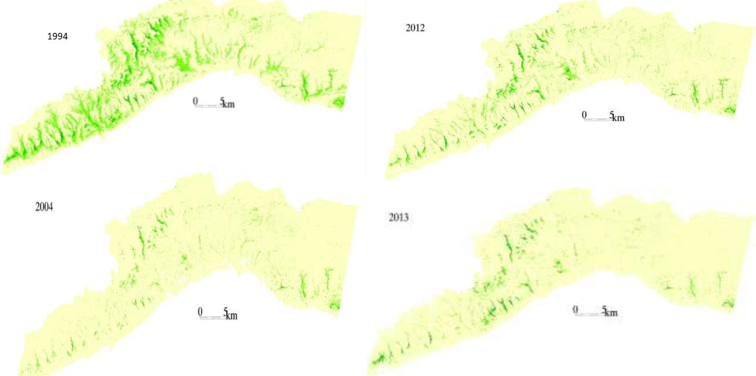
NDVI change in the Dhofar Mountains from 1994-2013

MAPPING, MONITORING, AND MITIGATION OF LAND DEGRADATION IN THE SULTANATE OF OMAN (Оман)

MAPPING, MONITORING, AND MITIGATION OF LAND DEGRADATION IN THE SULTANATE OF OMAN

Тодорхойлолт

Mapping of land degradation in the Sultanate of Oman to identify areas with various degrees of degradation, and factors and processes causing degradation.

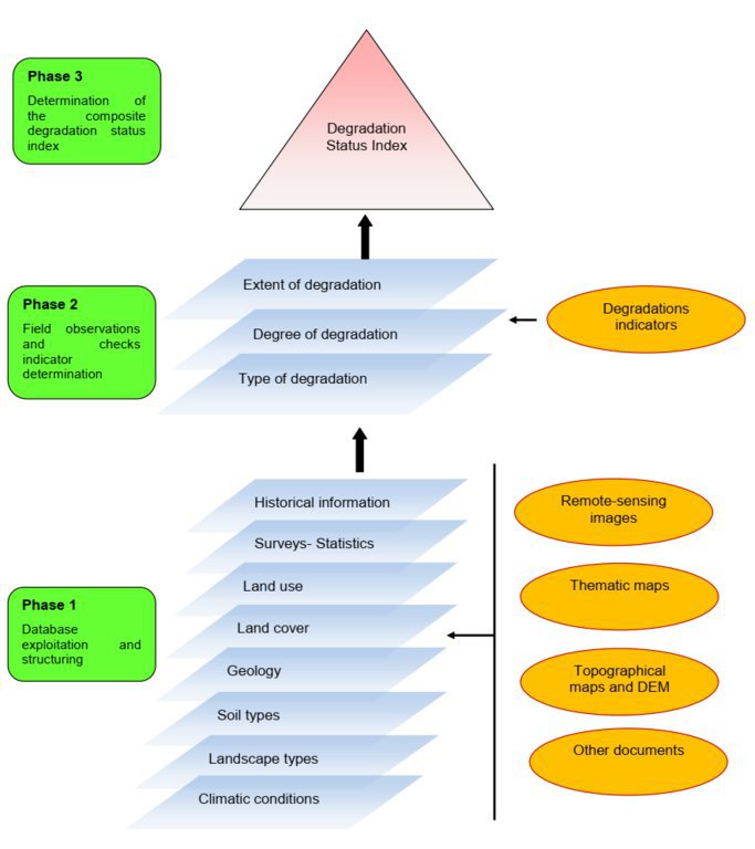
The Environment Authority has implemented land degradation mapping in the Sultanate of Oman in the Governorate of Dhofar, South and North Al Sharqiyah Governorates, and the Governorate of Al Dakhiliyah, in cooperation with Sultan Qaboos University, with the aim of identifying areas with various degrees of degradation and identifying the factors and processes causing degradation.
This investigation was based on high-resolution satellite imagery using NDVI as an Index of land degradation in the Dhofar Mountains and the invasion of mesquite (Prosopis juliflora.) in the plain of Salalah, as well as very high resolution aerial and satellite images of Jebal Al-Akhder derived from National Survey Authority. Precipitation data from two WMO stations were also utilized to test the link between precipitation and vegetation health. Vegetation was mapped to monitor changes and its health over time. In addition, a socio-economic survey in the Governorate of Dhofar was conducted, based on random sampling. The survey covered 6 different locations (Taqa, Taaqa farm, Zaik, Qiroon, Marbath, Al-Haqq and Taitam). The preliminary results clearly show that the study area has witnessed significant land use change between 1985 and 2013, marked by the emerging of a significant built-up area and water conservation infrastructure.
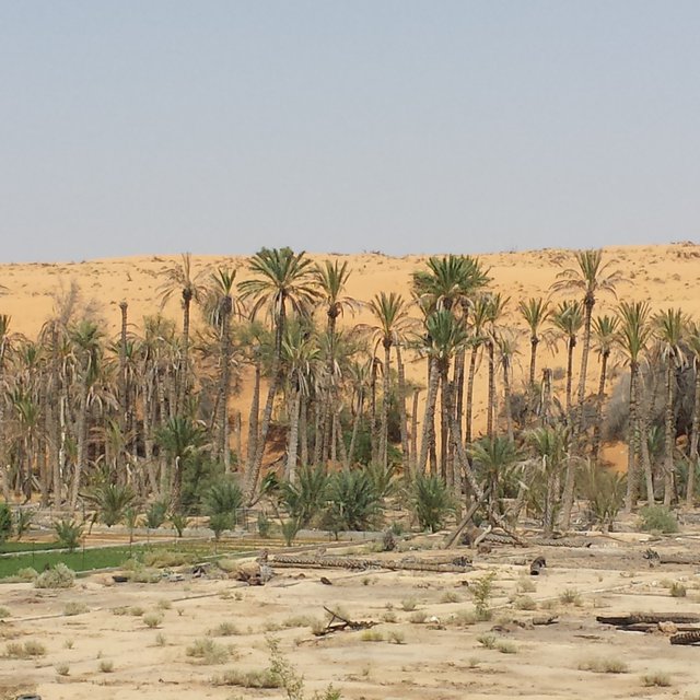
Spot images clearly show sharp changes in vegetation health through the years from 1994 to 2013. Vegetative vigour is lower in all years compared to 1994. Besides, the investigation shows a statistical relationship between rainfall and the status of the health of vegetation. Monsoon rainfall has an impact on the growth of vegetation. Around 2002-2003, the region suffered a major drought. Between 2012 and 2013, vegetative activity shows a decreasing trend. The analysis identified an area affected by the worst degree of land degradation. This area is situated in the southeastern of the Dhofar Mountains. In this area the process of land degradation is very active, with significant decrease in vegetation in 2013 compared to 2004. The mequite invasion in the Salalah Plain contributed to the degradation of natural vegetative cover in Dhofar Governorate. In nearly 30 years, the infested area almost quadrupled, indicating an average rate of expansion of 122,555m2 per year. The mesquite stands seem to have survived through the drought of 2002-2003.
The preliminary results of the survey clearly show that the mountains of Dhofar are under heavy anthropic pressure. The number of livestock is increasing and the native plant species are in great demand for cooking and heating.
Fortunately, the analysis identifies two areas, situated in the south-west of the study area, where vegetation has increased in vigor and density. The areas preserved from this process are usually inaccessible and far from human activities.
Vegetation cover change in Al-Jabal Al-Akhdar from 1985 to 2014 was analysed using very high resolution aerial and satellite images. Vegetation cover is also studied near settlements, dams, in wadis, and in agricultural areas. The change in total vegetation cover in the study area of Al-Jabal Al-Akhdar from 1985 to 2014 is very evident from the analysis of the data and maps produced.
Vegetation cover increased from 7.38 km2 during 1985 to 13.65 km2 in 2014. This change of vegetation cover was most noticeable in wadis and gullies where vegetation increased from 4.56 km2 during to 9.38 km2. One main factor that might be contributing to this increase of vegetation in wadis is the increase in the number of dams for storing surface water, as the number of dams increased from 7 in 1985 in the study area to 27 in 2014. Vegetation within and around 1 km of settlements in the study area increased from 2.09 km2 during 1985 to 5.45 km2 in 2014. In all other areas, that are distant from human activities, there is a considerable change in green vegetation cover between 1985 and 2014 where vegetation cover increased from 2.49 km2 in 1985 to 3.91 km2 in 2014. It is important to note here that vegetation cover density has a strong correlation with the amount of rainfall in Al-Jabal Al-Akhdar and there was a large difference in the annual rainfall between the two years, i.e. 1985 and 2014. The annual rainfall in 1985 was about 150mm for that particular year. The year 1984 was not much better where annual rainfall was lower than 200mm according to available records. The annual rainfall in 2013, the year preceding date of image in 2014, was 466mm, which is three times higher that that of 1985. Given the results of this study, there is a clear indication that the amount of rainfall plays a major role in defining the density of vegetation cover even if land degradation is taking place in very localized areas where there is pressure from grazing, urbanization, and tourism.

Байршил

Байршил: Governorate of Dhofar: Taqa, Taaqa farm, Zaik, Qiroon, Marbath, Al-Haqq and Taitam Governorate of Al Dakhiliyah: Al-Jabal Al-Akhdar, Governorate of Dhofar, North and South Al Sharqiyah Governorates and Governorate of Al Dakhiliyah, Оман

Сонгосон байршлуудын газарзүйн холболт
  • тодорхойгүй

Эхлэх огноо: 2013

Төгсөх жил: тодорхойгүй

Арга барилын төрөл
Hawiya Stakeholders (Malik Al-Wardy)
Degraded Hawiya Oasis: Diminishing water table levels have caused the main falaj (water canal) to dry out resulting in vegetation loss, sand dunes taking over, and land degradation (malik Al-Wardy)

Арга барилын зорилго ба эерэг нөлөө

Арга барилын үндсэн зорилго, зорилт
1.Monitoring and survey of land degradation and areas vulnerable to degradation
2.Enhancing human abilities in land degradation issues
3.Identifying various degrees of degraded areas, and factors and processes causing degradation
4.Regular monitoring of degraded areas
Тухайн Арга барилын хүрээнд нэвтрүүлсэн Технологийг хэрэгжүүлэхэд дэмжлэг болох нөхцлүүд
  • Нийгэм / соёл / шашны хэм хэмжээ, үнэт зүйлс: Cultural and religious values encourage the protection of land and planting of trees
  • Талуудыг хамтын ажиллагаа/зохицуулалт: There is always a good collaboration between the government and academic/research institutions to determine the right approaches and technologies for better management practices
Тухайн Арга барилын хүрээнд нэвтрүүлсэн Технологийг хэрэгжүүлэхэд хүндрэл учруулах нөхцлүүд
  • Хууль, эрхзүйн хүрээ (газар эзэмшил, газар, ус ашиглах эрх): In some regions land tenure is not defined which affects grazing activities in these regions making it difficult to implement any replanting or reforestation projects

Талуудын оролцоо ба үүрэг

Арга барилд оролцогч талууд болон тэдгээрийн үүрэг
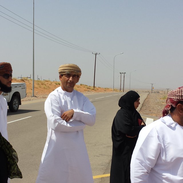
Ямар оролцогч талууд / хэрэгжүүлэгч байгууллагууд арга барилд оролцож байсан бэ? Оролцогч талуудыг тодорхойлно уу Оролцогч талуудын үүргийг тайлбарлана уу
Судлаачид Researchers from Sultan Qaboos University Approach development, analysis, and survey
Орон нутгийн захиргаа Municipalities, Authority departments, and Governor's offices Field visits and survey, meeting community
Засгийн газар (шийдвэр гаргагч, төлөвлөгч) Environment Authority Funding, planning approach
Арга барилын янз бүрийн үе шатанд орон нутгийн газар ашиглагчид / бүлгүүдийг татан оролцуулах
үгүй
идэвхигүй
Гадаад дэмжлэг
интерактив
өөрийн хүчийг нэгтгэсэн
санаачлага/идэвхжүүлэлт
x
Governor's offices in respective regions played a major role in motivating community leaders to participate in the project
Хэрэгжилт
x
Regional directorates and Governor offices helped in organizing meetings with local communities to collect information about land use activities, including farming and grazing, in their respective villages
Арга барил хэрэгжүүлэх бүдүүвч

ГТМ-ийн технологи сонгох шийдвэр гаргах явц

Шийдвэр гаргасан этгээд

  • Газар ашиглагч дангаараа (өөрийн санаачлага)
  • ГТМ-ийн мэргэжилтнүүдийн дэмжлэгтэйгээр, голчлон газар ашиглагчид
  • оролцооны зарчмын хэсэг болох бүх холбогдох талууд
  • голдуу ГТМ-ийн мэргэжилтнүүд, газар ашиглагчидтай зөвлөлдсөний үндсэн дээр
  • ГТМ-ийн мэргэжилтэн дангаараа
  • улс төрчид / удирдагчид

Шийдвэр гаргах үндэслэл нь

  • ГТМ-ийн мэдлэгийг баримтжуулалтын үнэлгээ (нотолгоонд суурилсан шийдвэр гаргах)
  • Судалгааны үр дүн, ололтууд
  • Хувь хүний туршлага ба санал бодол (баримтжуулаагүй)

Техникийн туслалцаа, чадавхи бий болгох болон мэдлэгийн менежмент

Дараах үйл ажиллагаа эсвэл үйлчилгээ нь арга барилын нэг хэсэг болсон
Чадавхи бэхжүүлэх / сургалт
Дараах сонирхогч талуудад сургалт хийсэн
  • Газар ашиглагчид
  • хээрийн ажилтан / зөвлөх
Сургалтын хэлбэр
  • Ажил дээр
  • фермерээс -фермер
  • үзүүлэнгийн талбай
  • Олон нийтийн уулзалт
  • курс дамжаа
Хамарсан сэдэв

1.Understanding GIS and geographical approach to land degradation
2. Use of remote sensing techniques for data collection
3. Land degradation assessment in drylands

Институцийг бэхжүүлэх
Институци бэхжисэн / бий болсон
  • Үгүй
  • Тийм, бага
  • Тийм, дунд зэрэг
  • Тийм, маш их
дараах түвшинд
  • Орон нутгийн
  • Бүс нутгийн
  • Үндэсний
Байгууллага, үүрэг, хариуцлага, гишүүд зэргийг тодорхойлно уу.
Дэмжлэгийн төрөл
  • Санхүүгийн
  • чадавхи бэхжүүлэх / сургалт
  • Тоног төхөөрөмж
Дэлгэрэнгүй мэдээлэл
Мониторинг ба үнэлгээ
Судалгаа
Судалгаа нь дараах сэдвийг хамарсан
  • Социологи
  • Эдийн засаг/ зах зээл
  • Экологи
  • Технологи

Санхүүжилт болон хөндлөнгийн материаллаг дэмжлэг

ГТМ-ийн бүрэлдэхүүн хэсгийн жилийн төсөв ам.доллараар
  • < 2,000
  • 2,000-10,000
  • 10,000-100,000
  • 100,000-1,000,000
  • > 1,000,000
Precise annual budget: тодорхойгүй
Газар ашиглагч нарт дараах урамшуулал, үйлчилгээг үзүүлсэн
  • Газар ашиглагчдад санхүүгийн / материаллаг дэмжлэг үзүүлсэн
  • Тодорхой хөрөнгө оруулалтанд нөхөн олговор олгох
  • Кредит
  • Бусад урамшуулал, хэрэгсэл

Нөлөөллийн дүн шинжилгээ ба дүгнэлт

Арга барилын үр нөлөө
Үгүй
Тийм, бага зэрэг
Тийм, зарим
Тийм, их
Арга барил нь орон нутгийн газар ашиглагчдыг чадваржуулах, оролцогч талуудын оролцоог сайжруулсан уу?

Stakeholders participated in collecting social data by visiting different towns and sitting with the community to explain the approach, define the problems, and evaluate solutions

x
Арга барил нь нотолгоонд суурилсан шийдвэр гаргах боломж олгосон уу?

Solutions and practices suggested resulted from extensive field work and image analysis

x
Арга барил нь ГТМ-ийн хэрэгжилтийн санхүүгийн эх үүсвэрийн хүртээмжийг сайжруулах / эргэлтэнд оруулахад чиглэсэн үү?

Financial resources were mobilized and directed towards plantation of trees in degraded lands

x
Энэ арга барил бусад сонирхогч талуудын мэдлэг, чадавхийг сайжруулсан уу?

Training courses were developed for government staff to collect field and social data

x
Арга барил нь оролцогч талуудын хооронд институци, хамтын ажиллагааг бий болгож, бэхжүүлсэн үү?

x
Газар ашиглагчид ГТМ хэрэгжүүлэх болсон үндсэн шалтгаан
Арга барилын хүрээнд хэрэгжүүлсэн үйл ажиллагааны тогтвортой байдал
Газар ашиглагчид арга барилаар дамжуулан хэрэгжүүлсэн арга хэмжээг тогтвортой үргэлжлүүлж чадах уу (гадны дэмжлэггүйгээр)?

Дүгнэлт, сургамж

Давуу тал: газар ашиглагчийн бодлоор
Давуу тал: эмхэтгэгч эсвэл бусад мэдээлэл өгсөн хүмүүсийн бодлоор
  • 1-As the results show that the amount of rainfall plays a major role in defining the density of vegetation, water catchment techniques can be deployed during rainfall periods – especially during Dhofar monsoon characterized with white fog and light rains- such as fog harvesting, increasing recharge dams, using new irrigation techniques from dams for affected areas
  • 2-By mapping land degradation in the Sultanate, areas that need protective strategies and policies can be defined, to avoid the degradation of areas of similar features through the coordination with respective sectors including urban planning, tourism, and agriculture.
  • 3- As the analysis identifies areas where vegetation has increased in vigor and density, factors leading to that may be explored and studied in order to apply same factors in similar environments.
Сул тал/ дутагдал / эрсдэл: газар ашиглагчийн бодлоордаван туулах боломжууд
Сул тал/ дутагдал / эрсдэл: эмхэтгэгч эсвэл бусад мэдээлэл өгсөн хүмүүсийн бодлоордаван туулах боломжууд
  • 1-As the spread and type of vegetation and climatic conditions differs greatly from area to area in the Sultanate of Oman, different procedures and techniques need to be employed. studying the general conditions and features of each area and applying different procedures and techniques based on specific characteristics.
  • 2-Analysis of vegetation change using satellite images in terrain characterized by deep slopes and deep valleys in some areas in the Sultanate is very difficult. using very high resolution remotely sensed images
  • 3-High resolution remotely sensed images are sometimes unavailable for past periods, which hinder studying vegetation change in this region where using satellite is difficult as well.

Суурь мэдээлэлүүд

Эмхэтгэгч
  • Laila AlShmali
Хянан тохиолдуулагчид
Хянагч
  • William Critchley
  • Rima Mekdaschi Studer
Баримтжуулсан огноо: 01 8-р сар 2021
Сүүлийн шинэчлэл: 09 9-р сар 2021
Мэдээлэл өгсөн хүн
WOCAT мэдээллийн сан дахь бүрэн тодорхойлолт
Холбогдох ГТМ мэдээлэл
Баримтжуулалтыг зохион байгуулсан
Байгууллага Төсөл
This work is licensed under Creative Commons Attribution-NonCommercial-ShareaAlike 4.0 International